Event Summary:
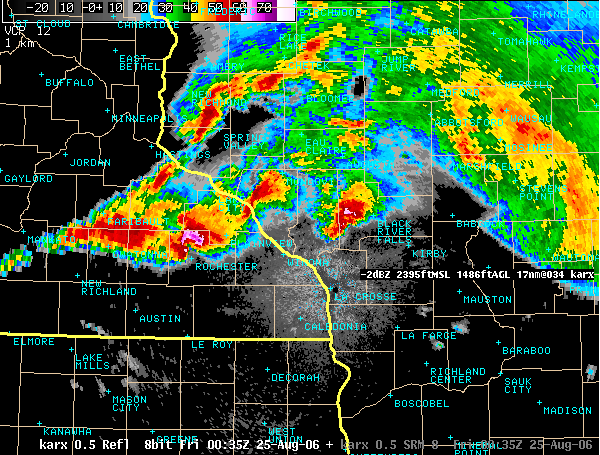
A stationary front extended across southern Minnesota, into western Wisconsin, and finally into southeastern Wisconsin for much of the week. This front divided very warm and unstable air over Iowa and cooler air to the north of the front. Strong south winds were in place moving the warm, unstable air over Iowa northward up and over the colder air initiating thunderstorms. Winds above the surface were unusually strong, creating the most organized and most dangerous of all thunderstorms: the supercell. Supercells can spawn violent, killer tornadoes. Fortunately, these supercells formed on the cooler side and away from the stationary frontal boundary - prompting high winds, large hail, and very heavy rain - but not tornadoes.
Supercells tracked across mainly central Wisconsin on the afternoon and evening of Wednesday August 23rd. This prompted over 25 warnings (from the National Weather Service in La Crosse Wisconsin) beginning at 3 pm and mainly for Clark, Jackson, Monroe, and Juneau counties. The atmosphere remained fairly stagnant in its features for storm development, so many thunderstorms initiated and tracked over the same areas. The most significant damage occurred over Monroe county near Tomah where damage from 65-75 mph winds and golf ball-sized hail was widespread. Storms finally weakened below severe limits after 2 a.m.
The frontal boundary became active again on the morning of Thursday August 24th. Fourteen (14) Severe Thunderstorm warnings were issued for southeastern Minnesota into southwestern Wisconsin between 10 am and 1 pm. The storms mainly affected areas along a line from south of Minneapolis, to Rochester Minnesota, to La Crosse, to Viroqua Wisconsin.
Finally, an area of low pressure developed over the Dakotas and shifted east later on Thursday, increasing the already favorable wind fields across southern Minnesota and western Wisconsin. More supercells developed and tracked west to east, just north of the Interstate 90 corridor in the late afternoon across Buffalo, Trempealeau, and Jackson Counties in western Wisconsin. This line of supercells slowly shifted south through the evening and affected the Interstate 90 corridor itself from Austin to Rochester to Winona Minnesota with high winds and hail. The Rochester Airport had a measured wind gust of 74 mph at 8:29 p.m. Conditions were favorable further west toward I-35 in south-central Minnesota for supercell spawned tornadoes and some of these did occur. The storms slowly decreased in intensity after 10 p.m. but continued to produce heavy rainfall with flash flooding over southern Minnesota. Twenty six (26) severe weather warnings were issued between 5 p.m. and Midnight.
Storms again increased in intensity early Friday morning over southwestern Wisconsin and another 5 Severe Thunderstorm warnings were issued, mainly for large hail.
Information on the different aspects of the severe weather outbreak are below.
| Wednesday 7am - Thursday 7am (Aug 23-24): | Radar Estimated |
| Thursday 7am - Friday 7am (Aug 24-25): | Radar Estimated |
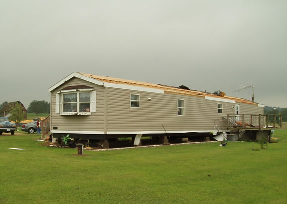
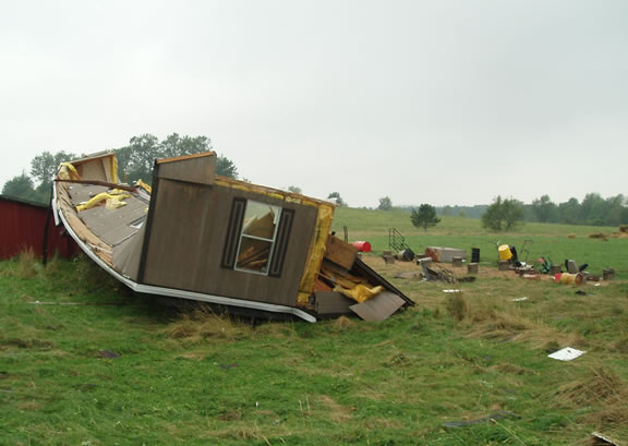
Severe thunderstorms during the afternoon and evening of August 23, 2006 produced straight line winds in excess of 55 mph as well as golf ball to tennis ball (1.75 to 2.25 inch diameter) hail over portions of eastern Monroe County in West Central Wisconsin. Minor to moderate structural damage as well as extensive crop damage occurred over an area of approximately 125 square miles extending from the community of Tomah, WI, north to Warrens, WI.
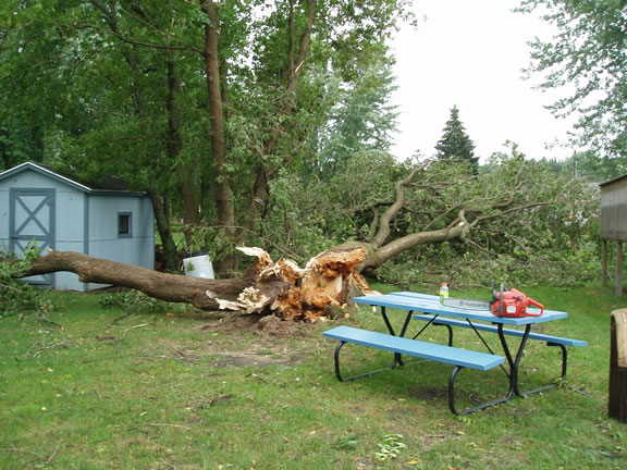
Wind damage was mainly in the form of downed trees and branches, but there was also some structural damage caused by the wind and by the wind indirectly from the falling trees and branches. The greatest wind damage occurred over a small area approximately midway between Tomah and Warrens where one mobile home was significantly damaged and another was overturned and effectively demolished.
Golf ball to tennis ball (1.75 to 2.25 inch) sized hail caused major crop damage over mainly the northern two-thirds of the affected area. Foliage was almost completely stripped from much of the corn and soybean crop. The cranberry crop was also hit hard with some growers estimating 70% loss.
 |
 |
|
| Mobile home damage north of Tomah, WI | ||
 |
 |
|
| Tree damage in the community of LaGrange | ||
 |
 |
|
| Hail damage to crops Tomah to Warrens, WI | ||
 |
 |
|
| Hail near Warrens, WI | ||
 |
||
| Large hail gathered by Nick Long in Tunnel City (west of Tomah) | ||
 Supercell moving toward Tomah around 7 pm Wednesday night (August 23 2006) |
 Large hail near Neillsville, WI. Observed Wednesday evening, Aug.23rd. |
 Line of supercell storms around 730 pm Thursday |
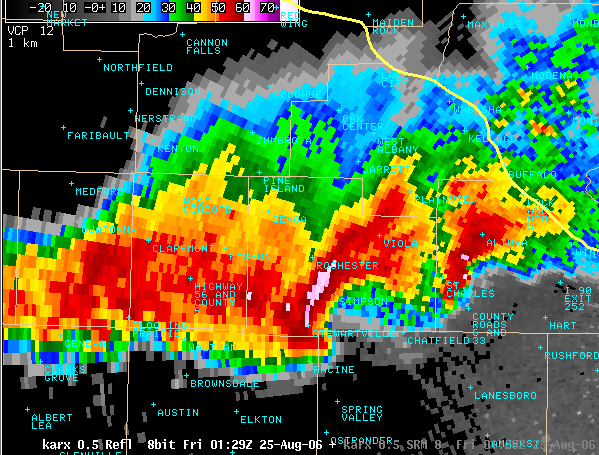 Storm moving through Rochester when 74 mph wind was measured around 830 pm Thursday |


 Weather Story
 Weather Map
 Local Radar