Overview
|
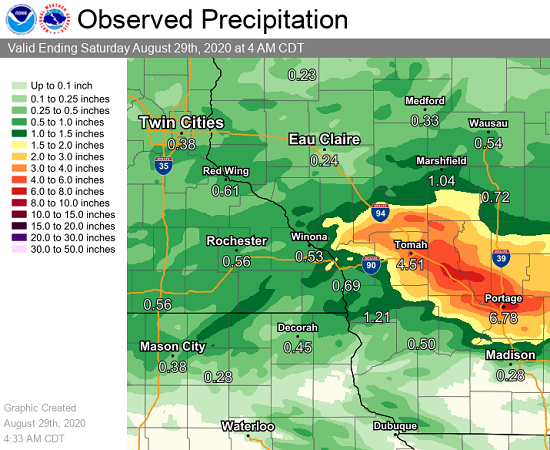
Storms that repeated over parts of west-central Wisconsin from the late evening hours of August 27 into the early morning hours of August 28 resulted in an area of very heavy rainfall and flash flooding. Roughly 4 to 8" fell between La Crosse, WI and Portage, WI. High water over roadways, washed out culverts, and a mudslide were reported by local officials. A thunderstorm complex that moved through later in the morning of August 28 then added an additional 0.5 to 1" to this same area, resulting in some places receiving upwards of 9" of rain. |
|
Photos & Video:
Header
 |
 |
 |
 |
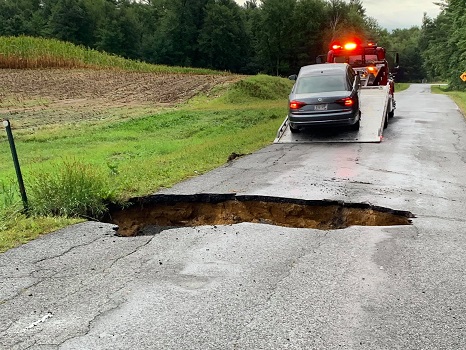
| Washed out culvert in rural Monroe County (Courtesy of Monroe County Sheriff Dept.) |
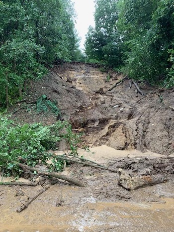
Mudslide near Oakdale, WI (Courtesy of Monroe County EM) |
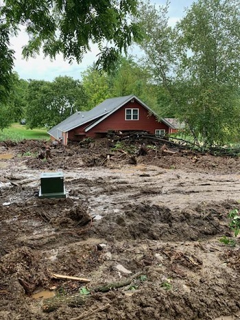
Mudslide near Oakdale, WI (Courtesy of Monroe County EM) |
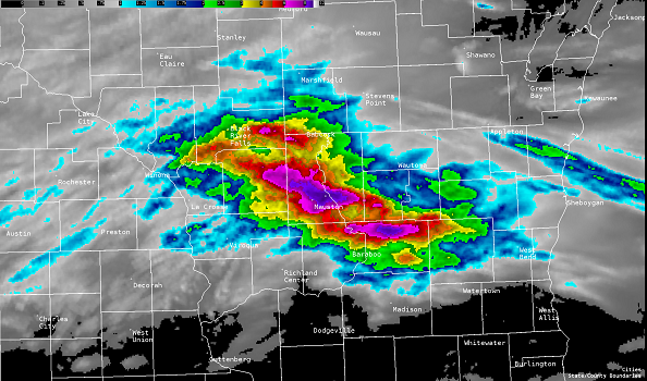
Radar Estimated Precipitation (NWS La Crosse) |
Storm Reports
PRELIMINARY LOCAL STORM REPORT...SUMMARY
NATIONAL WEATHER SERVICE LA CROSSE WI
426 AM CDT SAT AUG 29 2020

..TIME...   ...EVENT...      ...CITY LOCATION...     ...LAT.LON...
..DATE...   ....MAG....      ..COUNTY LOCATION..ST.. ...SOURCE....
            ..REMARKS..

0444 PM     FLASH FLOOD      4 WSW WHITE CREEK       43.80N 89.93W
08/28/2020                   JUNEAU             WI   EMERGENCY MNGR

            WATER STILL SURROUNDING HOMES AND ROAD
            CLOSURES.

0444 PM     FLASH FLOOD      3 SSE WHITE CREEK       43.79N 89.83W
08/28/2020                   ADAMS              WI   EMERGENCY MNGR

            FLOODING NOTED AT FERN AND 15TH.

0700 AM     FLASH FLOOD      2 WNW TUNNEL CITY       44.02N 90.61W
08/28/2020                   MONROE             WI   EMERGENCY MNGR

            CULVERT WASHED OUT IN TOWN OF GREENFIELD LED
            TO ACCIDENTS AND FLIPPED OVER MILK TRUCK.

0650 AM     FLASH FLOOD      3 WNW TUNNEL CITY       44.02N 90.61W
08/28/2020                   MONROE             WI   LAW ENFORCEMENT

            DELAYED REPORT. ROAD WASHED OUT.

0440 AM     FLASH FLOOD      TOMAH                   43.99N 90.50W
08/28/2020                   MONROE             WI   LAW ENFORCEMENT

            REPORTS OF FLOODED ROADS IN THE TOMAH AREA.

1000 AM     FLASH FLOOD      3 N PLAINVILLE          43.76N 89.82W
08/28/2020                   ADAMS              WI   LAW ENFORCEMENT

            WATER OVER PARTS OF FREEDOM COURT AND 13TH
            COURT IN SOUTHWEST PART OF COUNTY.

0200 AM     FLASH FLOOD      3 N PLAINVILLE          43.76N 89.82W
08/28/2020                   ADAMS              WI   LAW ENFORCEMENT

            ROAD WASHED OUT.

0700 AM     FLASH FLOOD      3 SSE OAKDALE           43.93N 90.36W
08/28/2020                   MONROE             WI   EMERGENCY MNGR

            MUDSLIDE TOOK HOUSE OFF FOUNDATION ALONG
            HOPE ROAD BETWEEN CLIFTON AND OAKDALE.

0159 PM     FLASH FLOOD      3 NW NEW LISBON         43.91N 90.20W
08/28/2020                   JUNEAU             WI   LAW ENFORCEMENT

            STILL REPORTING WATER OVER RURAL ROADS AND A
            FEW COUNTY ROADS.

0859 AM     FLASH FLOOD      4 N MAUSTON             43.85N 90.07W
08/28/2020                   JUNEAU             WI   LAW ENFORCEMENT

            MANY BACK ROADS WITH WATER OVER THEM. WORST
            IMPACT IS NEAR INTERSTATE 90/94 AREAS.

0600 AM     FLASH FLOOD      MAUSTON                 43.80N 90.08W
08/28/2020                   JUNEAU             WI   LAW ENFORCEMENT

            MULTIPLE ROADS AND HIGHWAYS ACROSS SOUTHERN
            JUNEAU COUNTY WITH WATER OVER THEM. CULVERTS
            ALSO REPORTS AS BEING WASHED OUT.

0443 AM     FLASH FLOOD      1 SE MAUSTON            43.79N 90.06W
08/28/2020                   JUNEAU             WI   LAW ENFORCEMENT

            WATER OVER ROADWAYS.

0442 AM     FLASH FLOOD      MAUSTON                 43.80N 90.08W
08/28/2020                   JUNEAU             WI   LAW ENFORCEMENT

            WATER COMING UP UNDER TO DOOR AT THE
            SHERIFFS OFFICE.

0645 AM     FLASH FLOOD      4 N CAMP DOUGLAS        43.97N 90.27W
08/28/2020                   JUNEAU             WI   PUBLIC

            DELAYED REPORT. ROAD CLOSED DUE TO HIGH
            WATER.


&&

$$
Rain Reports
Public Information Statement
National Weather Service La Crosse WI
117 PM CDT Fri Aug 28 2020

...24 HOUR RAINFALL REPORTS...

Location                     Amount    Time/Date       Lat/Lon

...Iowa...

...Allamakee County...
3 S Dorchester               0.31 in   1015 AM 08/28   43.42N/91.51W

...Chickasaw County...
5 NE New Hampton             0.24 in   1245 PM 08/28   43.13N/92.26W
Ionia 2W                     0.12 in   1230 PM 08/28   43.03N/92.50W
New Hampton                  0.09 in   0100 PM 08/28   43.06N/92.32W

...Fayette County...
Eldorado 1E - Turkey River   0.24 in   1245 PM 08/28   43.05N/91.81W

...Floyd County...
Charles City                 0.05 in   1215 PM 08/28   43.06N/92.67W
2 NE Dougherty               0.02 in   1255 PM 08/28   42.95N/93.01W

...Howard County...
Elma                         0.78 in   0700 AM 08/28   43.24N/92.44W
Riceville                    0.74 in   1230 PM 08/28   43.36N/92.48W
3 E Elma                     0.68 in   1255 PM 08/28   43.25N/92.38W
Saratoga                     0.50 in   1231 PM 08/28   43.35N/92.42W

...Mitchell County...
St.Ansgar                    0.08 in   1230 PM 08/28   43.38N/92.92W

...Winneshiek County...
1 ENE Bluffton               0.20 in   1230 PM 08/28   43.41N/91.90W
Spillville                   0.20 in   1000 AM 08/28   43.21N/91.95W
Decorah                      0.17 in   0100 PM 08/28   43.30N/91.79W
1 ENE Jackson Junction       0.16 in   1045 AM 08/28   43.11N/92.04W

...Minnesota...

...Dodge County...
Mantorville                  0.70 in   1052 AM 08/28   44.07N/92.76W
2 WNW Byron                  0.61 in   1255 PM 08/28   44.05N/92.69W
Mantorville 1.9 ESE          0.53 in   0830 AM 08/28   44.05N/92.72W
Hayfield 0.3 SSE             0.53 in   0800 AM 08/28   43.89N/92.85W
Hayfield                     0.50 in   1257 PM 08/28   43.89N/92.85W
Claremont 2.5 ESE            0.40 in   0800 AM 08/28   44.04N/92.95W

...Fillmore County...
2 S Pilot Mound              1.01 in   1015 AM 08/28   43.78N/92.03W
Lanesboro                    0.95 in   1145 AM 08/28   43.72N/91.98W
2 S Pilot Mound              0.80 in   0830 AM 08/28   43.78N/92.03W
Preston 3.2 NNE              0.79 in   1000 AM 08/28   43.71N/92.05W
Preston Airport              0.64 in   1255 PM 08/28   43.68N/92.17W
1 NNW Fillmore               0.58 in   1015 AM 08/28   43.76N/92.27W

...Houston County...
Mound Prairie                1.97 in   0900 AM 08/28   43.78N/91.45W
Houston                      1.68 in   1255 PM 08/28   43.77N/91.58W
1 NNE Houston                1.24 in   1145 AM 08/28   43.77N/91.57W
3 SSW Freeburg               0.80 in   0716 AM 08/28   43.57N/91.39W
1 SSE Brownsville            0.42 in   1130 AM 08/28   43.69N/91.27W

...Mower County...
Austin 1.9 ENE               1.17 in   0800 AM 08/28   43.68N/92.94W
Austin 2.4 W                 1.10 in   0700 AM 08/28   43.67N/93.02W
Austin 1.5 WSW               1.09 in   0700 AM 08/28   43.67N/93.00W
Austin 3 NW - Turtle Creek   1.08 in   0700 AM 08/28   43.65N/92.98W
Austin Waste Water Treatment 0.97 in   0700 AM 08/28   43.65N/92.97W
Austin 3S - Cedar River      0.32 in   1145 AM 08/28   43.64N/92.97W

...Olmsted County...
Rochester International Airp 1.44 in   0954 AM 08/28   43.90N/92.50W
Rochester 2.0 N              1.00 in   1036 AM 08/28   44.05N/92.48W
Rochester 0.8 WNW            0.92 in   0947 AM 08/28   44.02N/92.49W
Elgin 2SSW                   0.91 in   0700 AM 08/28   44.10N/92.27W
Rochester 2.0 NNE            0.90 in   0700 AM 08/28   44.04N/92.47W
Rochester                    0.89 in   1230 PM 08/28   44.05N/92.45W
6 NNW Genoa                  0.85 in   1115 AM 08/28   44.19N/92.65W
Byron                        0.74 in   1231 PM 08/28   44.04N/92.64W

...Wabasha County...
1 N Kellogg                  1.03 in   1100 AM 08/28   44.32N/92.00W
Theilman 1 SSW               0.87 in   0730 AM 08/28   44.28N/92.19W
3 ESE Mazeppa                0.84 in   1015 AM 08/28   44.26N/92.49W
Plainview                    0.76 in   1254 PM 08/28   44.17N/92.17W
Zumbro Falls 3.5 SSW         0.75 in   0700 AM 08/28   44.24N/92.46W
Plainview                    0.73 in   0824 AM 08/28   44.17N/92.17W
Wabasha                      0.70 in   1258 PM 08/28   44.30N/92.00W
Mazeppa 5.4 SSE              0.54 in   0800 AM 08/28   44.20N/92.50W
Lake City 0.1 E              0.29 in   0940 AM 08/28   44.44N/92.28W
Lake City                    0.28 in   1230 PM 08/28   44.44N/92.28W

...Winona County...
Beaver                       0.73 in   1100 AM 08/28   44.15N/92.00W
3 SW Elba                    0.48 in   1045 AM 08/28   44.06N/92.05W
1 ESE Winona                 0.46 in   1255 PM 08/28   44.04N/91.63W
1 WSW Elba                   0.41 in   1130 AM 08/28   44.09N/92.03W
Winona Municipal Airport     0.39 in   1255 PM 08/28   44.07N/91.70W
Dakota                       0.36 in   1215 PM 08/28   43.91N/91.36W
Saint Charles                0.34 in   0100 PM 08/28   43.97N/92.06W

...Wisconsin...

...Adams County...
Oxford 4.3 W                 4.88 in   0800 AM 08/28   43.79N/89.65W
Oxford 4.0 W                 4.03 in   0700 AM 08/28   43.79N/89.64W
4 ENE Plainville             3.50 in   1255 PM 08/28   43.74N/89.72W
Nekoosa 8.0 SSE              2.63 in   0900 AM 08/28   44.21N/89.85W
Grand Marsh 1.0 W            2.48 in   0700 AM 08/28   43.89N/89.73W
2.0 NW Strongs Prairie       2.10 in   0715 AM 08/28   44.08N/90.00W
0.6 W Friendship             2.02 in   0700 AM 08/28   43.98N/89.83W
Friendship 6.4 NNE           0.76 in   0700 AM 08/28   44.06N/89.79W
Nekoosa 6.6 SSE              0.69 in   0700 AM 08/28   44.22N/89.88W

...Buffalo County...
Mondovi 12.1 SSE             0.06 in   0700 AM 08/28   44.40N/91.60W
Dodge                        0.04 in   1245 PM 08/28   44.13N/91.55W
Alma Dam 4                   0.04 in   0800 AM 08/28   44.33N/91.92W

...Crawford County...
De Soto                      0.58 in   1251 PM 08/28   43.42N/91.19W
Steuben                      0.23 in   1100 AM 08/28   43.18N/90.86W
2.8 E Harpers Ferry          0.16 in   1100 AM 08/28   43.21N/91.10W

...Grant County...
Boscobel Airport             0.35 in   1253 PM 08/28   43.15N/90.68W
Boscobel                     0.31 in   1103 AM 08/28   43.15N/90.68W
Muscoda                      0.23 in   1255 PM 08/28   43.19N/90.46W

...Jackson County...
Black River Falls            3.25 in   0830 AM 08/28   44.29N/90.85W
1 E Black River Falls        3.15 in   1015 AM 08/28   44.30N/90.73W
North Bend                   2.82 in   1255 PM 08/28   44.10N/91.11W
Black River Falls 1.7 NNE    0.87 in   0700 AM 08/28   44.32N/90.83W
Black River Falls Area Airpo 0.62 in   0515 AM 08/28   44.25N/90.85W

...Juneau County...
New Lisbon                   9.54 in   1231 PM 08/28   43.87N/90.17W
Volk Field                   7.74 in   1256 PM 08/28   43.92N/90.27W
Mauston                      7.55 in   1257 PM 08/28   43.80N/90.07W
Necedah                      5.89 in   1248 PM 08/28   44.03N/90.08W
1 W Lyndon Station           5.22 in   1255 PM 08/28   43.71N/89.93W
2 N Cloverdale               4.99 in   1200 PM 08/28   44.06N/90.17W
Mauston Airport              4.29 in   1255 PM 08/28   43.83N/90.13W
Necedah 5.0 ESE              3.80 in   0700 AM 08/28   43.99N/89.99W
0.6 W Necedah                1.86 in   0848 AM 08/28   44.02N/90.08W

...La Crosse County...
1 NNW Onalaska               1.10 in   1053 AM 08/28   43.90N/91.23W
La Crosse                    1.02 in   1245 PM 08/28   43.77N/91.22W
West Salem                   1.02 in   0700 AM 08/28   43.90N/91.09W
La Crosse Regional Airport   0.84 in   1253 PM 08/28   43.88N/91.25W
Holmen 2S                    0.83 in   0700 AM 08/28
NWS La Crosse                0.68 in   1100 AM 08/28
Onalaska 2N                  0.53 in   0700 AM 08/28   43.91N/91.23W

...Monroe County...
4 NE Cataract                7.30 in   0931 AM 08/28   44.12N/90.77W
1 NNW Tomah                  5.60 in   0932 AM 08/28   44.00N/90.51W
3 NNE Tunnel City            5.00 in   1131 AM 08/28   44.04N/90.55W
Tomah                        5.00 in   0540 AM 08/28   43.99N/90.50W
Wilton                       4.00 in   0540 AM 08/28   43.81N/90.53W
2 E Cataract                 3.79 in   1258 PM 08/28   44.09N/90.79W
Cataract                     3.35 in   0614 AM 08/28   44.09N/90.84W
Warrens 4.7 WSW              2.68 in   0700 AM 08/28   44.10N/90.59W
Wilton 4.2 E                 2.05 in   0700 AM 08/28   43.81N/90.44W
Sparta 3.8 S                 1.70 in   0630 AM 08/28   43.89N/90.80W
Sparta/Fort McCoy Airport    1.61 in   1255 PM 08/28   43.97N/90.73W
3 SSW Sparta                 1.55 in   0515 AM 08/28   43.90N/90.83W
0.5 SW Sparta                1.42 in   0800 AM 08/28   43.94N/90.82W
Cashton 3 NNW                0.97 in   0742 AM 08/28   43.79N/90.80W

...Richland County...
1 SSE Richland Center        0.34 in   1259 PM 08/28   43.32N/90.38W

...Taylor County...
Gilman 8.2 NNW               0.64 in   0800 AM 08/28   45.28N/90.86W
Medford Airport              0.55 in   1255 PM 08/28   45.10N/90.30W
Medford                      0.45 in   0100 PM 08/28   45.30N/90.30W
3 NE Lublin                  0.37 in   1214 PM 08/28   45.11N/90.69W

...Trempealeau County...
Ettrick 3.2 NE               0.75 in   0650 AM 08/28   44.20N/91.23W
Galesville 4.7 E             0.64 in   0705 AM 08/28   44.08N/91.26W
Trempealeau Dam 6            0.63 in   0800 AM 08/28   44.00N/91.44W
Ettrick 4.0 WNW              0.61 in   0716 AM 08/28   44.19N/91.34W
Galesville 2WSW              0.61 in   0700 AM 08/28   44.07N/91.39W
Trempealeau                  0.50 in   1257 PM 08/28   44.07N/91.51W
Galesville 1.0 NE            0.26 in   0600 AM 08/28   44.10N/91.34W

...Vernon County...
Westby                       1.75 in   1111 AM 08/28   43.66N/90.86W
La Farge                     1.61 in   1216 PM 08/28   43.60N/90.63W
Hillsboro 0.5 WSW            1.56 in   0700 AM 08/28   43.65N/90.35W
Genoa Dam 8                  1.39 in   1000 AM 08/28   43.57N/91.23W
Hillsboro 2 SW               0.97 in   0700 AM 08/28   43.63N/90.38W
Viroqua Municipal Airport    0.67 in   1255 PM 08/28   43.58N/90.90W

Observations are collected from a variety of sources with varying
equipment and exposures. We thank all volunteer weather observers
for their dedication. Not all data listed are considered official.

$$
 |
Media use of NWS Web News Stories is encouraged! Please acknowledge the NWS as the source of any news information accessed from this site. |
|


 Weather Story
 Weather Map
 Local Radar