Overview
|
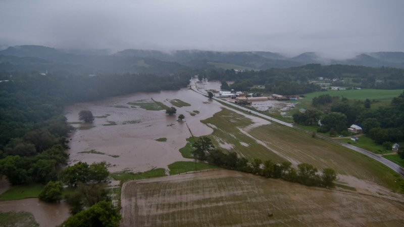
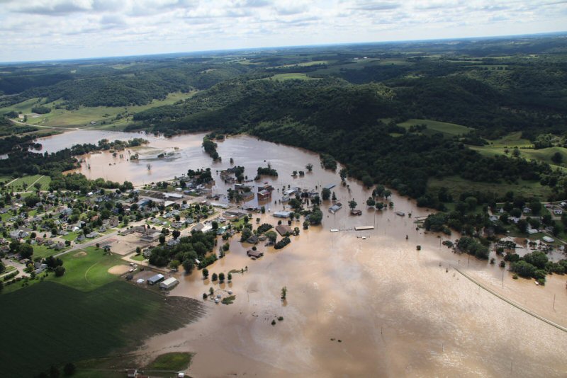
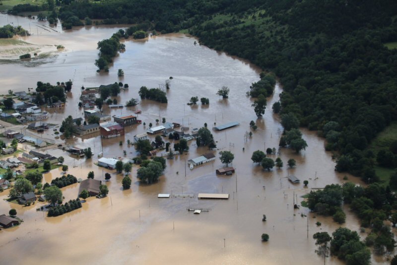
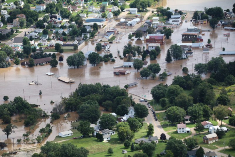
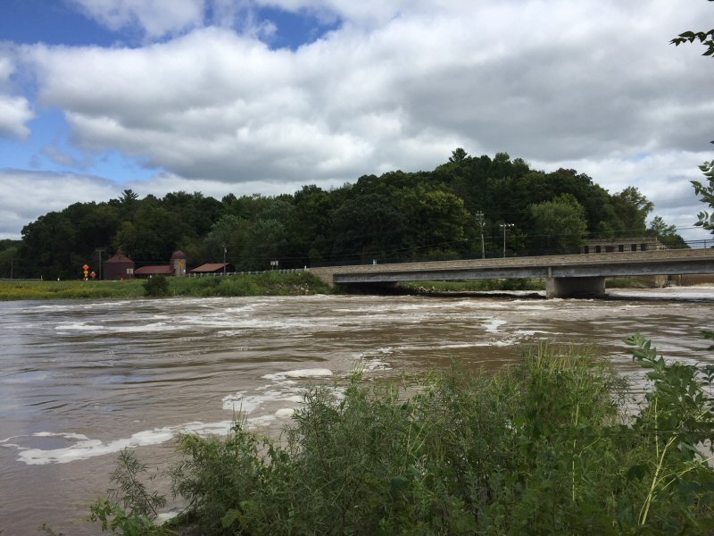
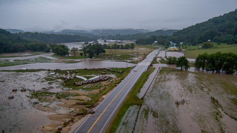
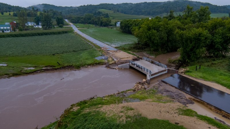
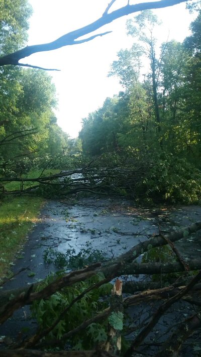
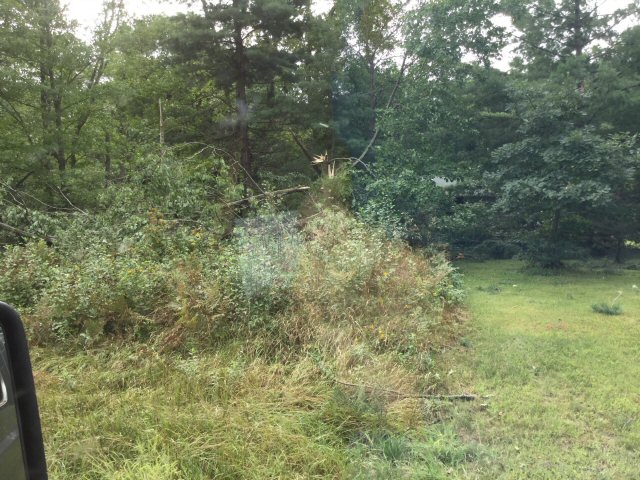
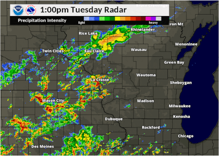
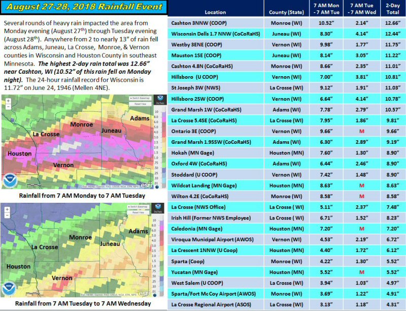
Several rounds of severe weather impacted the area from Monday August 27th through Tuesday August 28th. Major flash flooding occurred Monday night into Tuesday morning and additional flash flooding occurred Tuesday afternoon and evening. Record flooding occurred along portions of the Kickapoo River. A line of thunderstorms produced wind damage and an isolated tornado Monday afternoon and evening, with the severe threat quickly transitioning over to flash flooding Monday night into Tuesday morning. A storm produced large hail over portions of northeast Iowa Tuesday morning, then more severe thunderstorms developed Tuesday afternoon producing wind damage and additional flooding. Numerous communities in southwest Wisconsin experienced record flooding. This included evacuations and rescues during the peak of the flooding. |
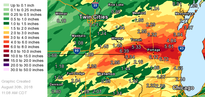
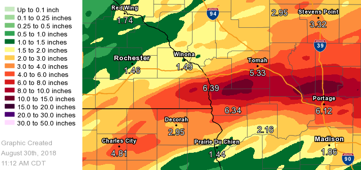
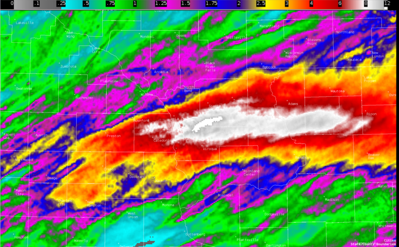 2-Day Radar Rainfall Estimates (Monday & Tuesday) |
Tornado:
|
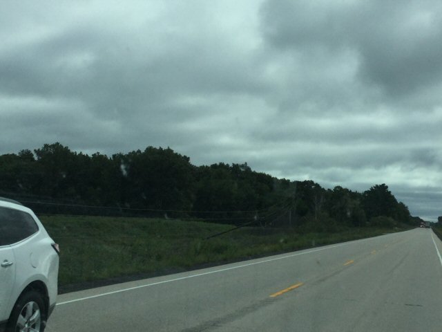
Tornado - Wyeville, WI
Track Map 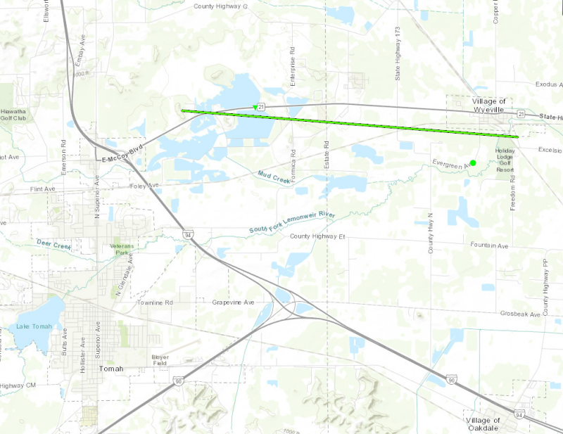 
|
||||||||||||||||
The Enhanced Fujita (EF) Scale classifies tornadoes into the following categories:
| EF0 Weak 65-85 mph |
EF1 Moderate 86-110 mph |
EF2 Significant 111-135 mph |
EF3 Severe 136-165 mph |
EF4 Extreme 166-200 mph |
EF5 Catastrophic 200+ mph |
 |
|||||
Flooding
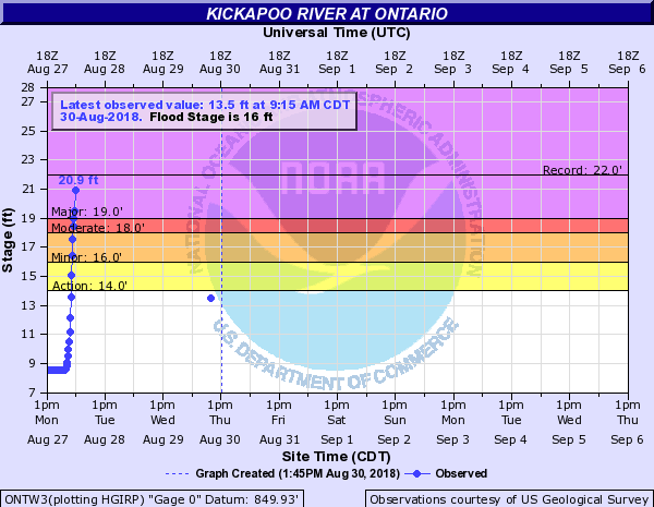
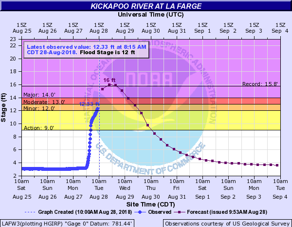
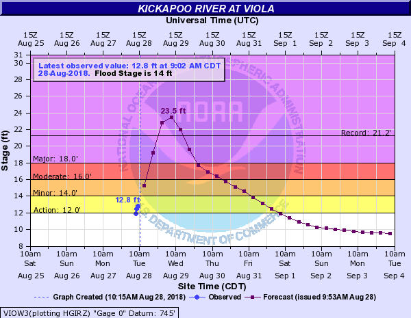
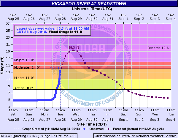
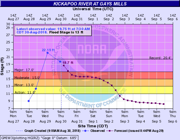
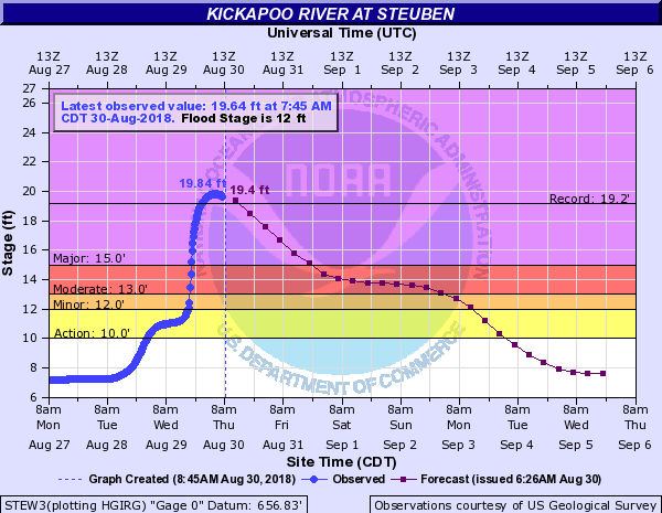
Hardest hit river basin was the Kickapoo and La Crosse Rivers in western and southwest Wisconsin. Many locations set record crest levels which may not be displayed on the hydrographs. Crest information will be added as it becomes official.
Kickapoo Hydrographs
 |
 |
 |
 |
| Kickapoo River at Ontario (2018 Record Crest: 28.50') |
Kickapoo River at La Farge (2018 Record Crest: 19.42') |
Kickapoo River at Viola (2018 Record Crest: 23.72') |
Kickapoo River at Readstown (2018 Record Crest: 23.17') |
.png) |
 |
 |
|
| Kickapoo River at Soldiers Grove (2018 Crest: 21.06') |
Kickapoo River at Gays Mills (2018 Record Crest: 22.31') |
Kickapoo River at Steuben (2018 Record Crest: 19.84') |
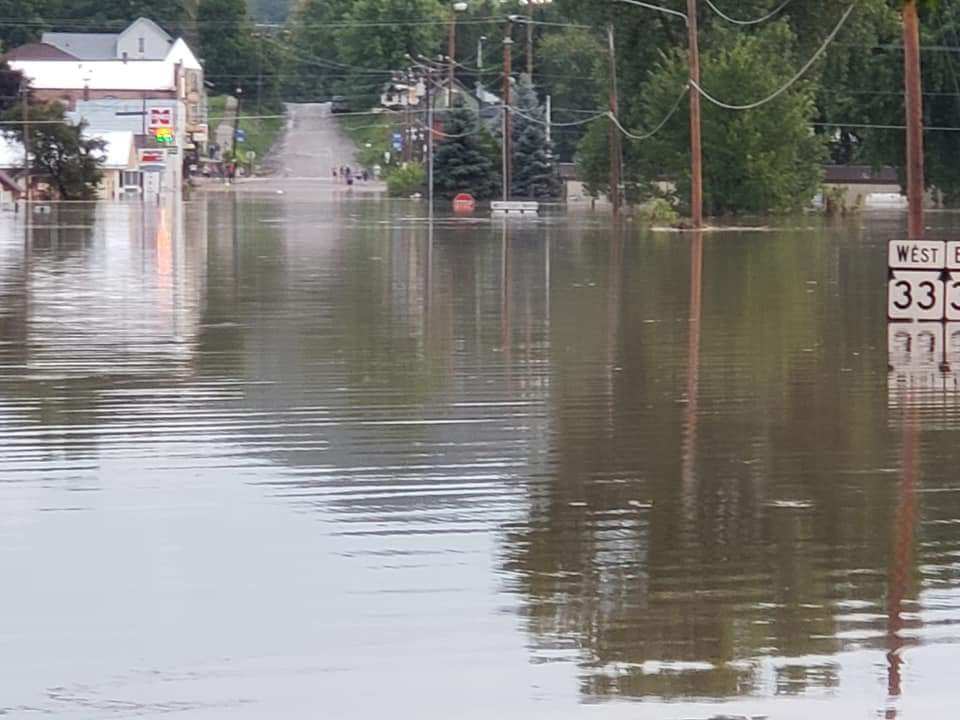
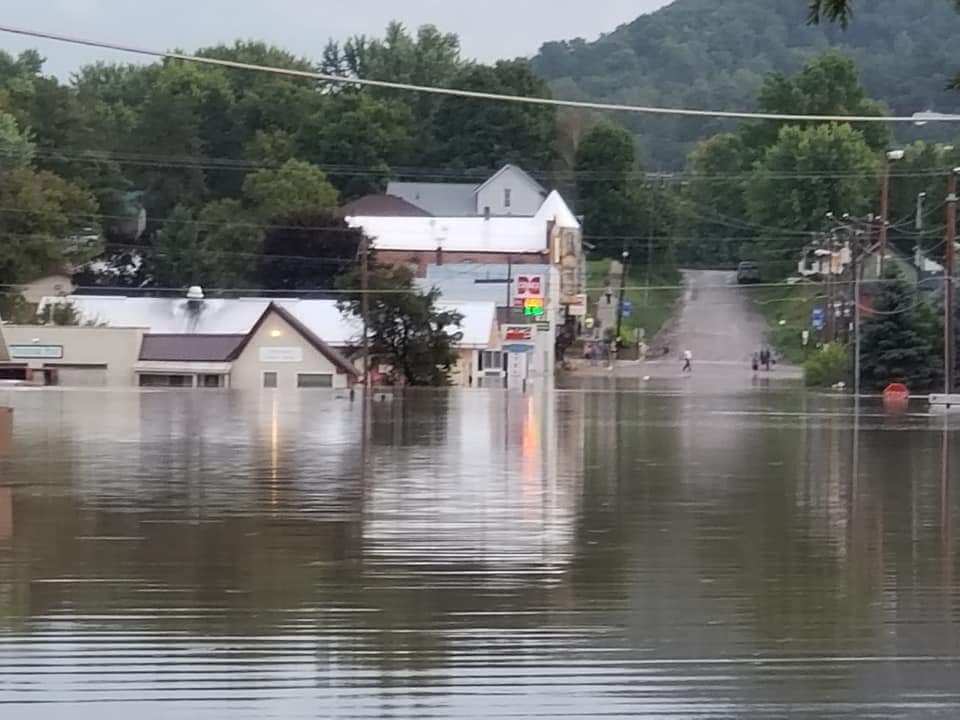
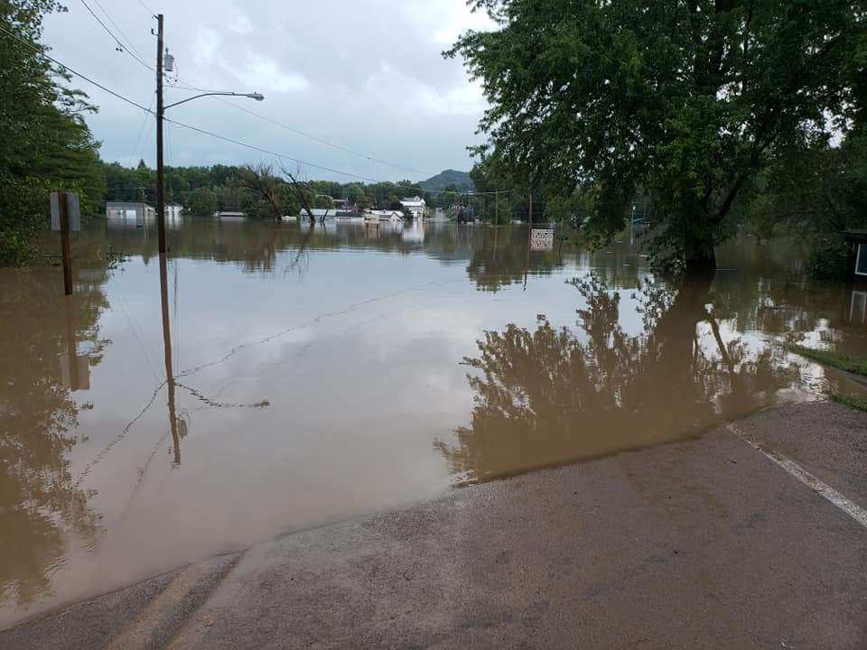
Photos
 |
 |
 |
 |
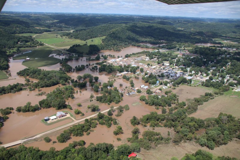
| Flooding in Ontario, WI (Photo by Fred Hill) |
Flooding in Ontario, WI (Photo by Fred Hill) |
Flooding in Ontario, WI (Photo by Fred Hill) |
Flooding in Ontario, WI (Courtesy WI Air Coordination Group) |
 |
 |
 |
 |
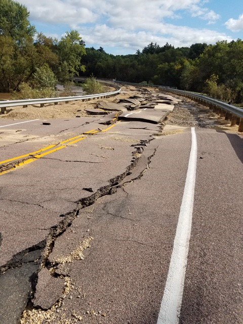
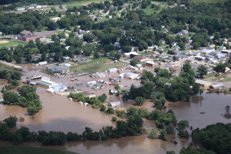
| Highway 131 between Ontario and Rockton, WI | Flooding in La Farge, WI (Courtesy WI Air Coordination Group) |
Flooding in La Farge, WI (Courtesy WI Air Coordination Group) |
Flooding in La Farge, WI (Courtesy WI Air Coordination Group) |
 |
 |
 |
 |
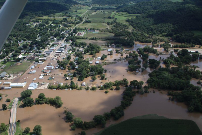
| Flooding in Viola, WI (Courtesy WI Air Coordination Group) |
Flooding in Viola, WI (Courtesy WI Air Coordination Group) |
Flooding in Viola, WI (Courtesy WI Air Coordination Group) |
Flooding along the La Crosse River, near the Neshonoc Dam (Photo by Dave Schmidt) |
 |
 |
||
| Flooding near the Monroe-Vernon county line (Courtesy WI Air Coordination Group) |
Flooding near the Monroe-Vernon county line (Courtesy WI Air Coordination Group) |
Photos:
 |
 |
 |
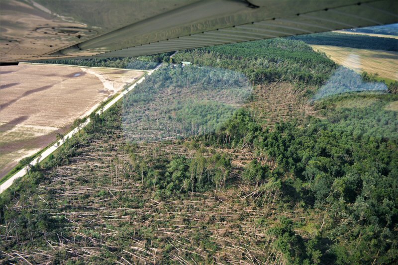
| Tornado damage near Wyeville, WI (Photo via Twitter @Wort_Wort_Wort) |
Tornado damage near Wyeville, WI (Photo via NWS Damage survey) |
Tornado damage near Wyeville, WI (Photo via NWS Damage survey) |
 |
||
| Wind damage in rural Adams County, WI (Photo by Adams Co. Emerg.Mgmt) |
Radar Images:
 |
 |
 |
|
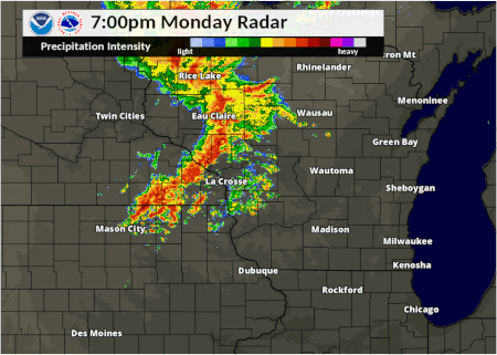
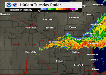
| Radar loop from Monday evening | Radar loop from Tuesday morning | Radar loop from Tuesday afternoon |
Storm Reports
Summary of Storm Reports from Monday August 27th through early morning Wednesday August 29th.
PRELIMINARY LOCAL STORM REPORT...SUMMARY
NATIONAL WEATHER SERVICE LA CROSSE WI
445 AM CDT WED AUG 29 2018

..TIME...   ...EVENT...      ...CITY LOCATION...     ...LAT.LON...
..DATE...   ....MAG....      ..COUNTY LOCATION..ST.. ...SOURCE....
            ..REMARKS..

0804 PM     TSTM WND GST     3 SW SPENCER            44.71N 90.34W
08/27/2018  E50 MPH          CLARK              WI   TRAINED SPOTTER

            TRAINED SPOTTER ESTIMATED WIND GUST OF 48 TO
            50 MILES PER HOUR 3 MILES SOUTHWEST OF
            SPENCER.

0556 PM     TSTM WND GST     3 WNW ROCHESTER         44.03N 92.52W
08/27/2018  M47 MPH          OLMSTED            MN   TRAINED SPOTTER

            TRAINED SPOTTER REPORTED A MEASURED WIND
            GUST OF 47 MILES PER HOUR.

0950 AM     HAIL             SAINT LUCAS             43.07N 91.93W
08/28/2018  E2.00 INCH       FAYETTE            IA   PUBLIC

            DELAYED REPORT VIA SOCIAL MEDIA. TIME
            ESTIMATED BY RADAR.

0300 PM     HAIL             4 SSW BROOKS            43.77N 89.69W
08/28/2018  E1.00 INCH       ADAMS              WI   TRAINED SPOTTER

            NICKEL TO QUARTER SIZE HAIL AND STRONG
            WINDS.

1034 AM     HAIL             3 W LUANA               43.06N 91.51W
08/28/2018  M0.88 INCH       CLAYTON            IA   EMERGENCY MNGR


0330 AM     FLASH FLOOD      HOKAH                   43.77N 91.34W
08/28/2018                   HOUSTON            MN   LAW ENFORCEMENT

            ROOT RIVER IS FLOWING OVER HIGHWAY 16.

0517 AM     FLASH FLOOD      4 S MAUSTON             43.74N 90.08W
08/28/2018                   JUNEAU             WI   DEPT OF HIGHWAYS

            WATER OVER PARTS OF WISCONSIN HIGHWAY 58
            SOUTH OF MAUSTON.

0134 PM     TSTM WND DMG     VIROQUA                 43.56N 90.89W
08/28/2018                   VERNON             WI   PUBLIC

            A COUPLE OF TREES BLOWN DOWN.

0230 AM     FLASH FLOOD      COON VALLEY             43.70N 91.01W
08/28/2018                   VERNON             WI   EMERGENCY MNGR

            SEVERE FLOODING OCCURRING IN COON VALLEY
            WITH EVACUATIONS IN PROGRESS. NUMEROUS ROADS
            ARE IMPASSABLE.

0830 PM     TSTM WND DMG     2 N TOMAH               44.02N 90.50W
08/27/2018                   MONROE             WI   LAW ENFORCEMENT

            REPORT OF A 24-FT CAMPER ROLLED INTO A
            TRANSFORMER. TIME ESTIMATED FROM RADAR.

0515 PM     FLOOD            2 N ROCKBRIDGE          43.48N 90.36W
08/28/2018                   RICHLAND           WI   LAW ENFORCEMENT

            REPORTS OF FLOODING ALONG THE PINE RIVER
            FROM YUBA DOWNSTREAM TO ROCKBRIDGE.

1200 AM     FLOOD            VIOLA                   43.51N 90.67W
08/29/2018                   RICHLAND           WI   EMERGENCY MNGR

            MAJOR FLOODING IN VILLAGE OF VIOLA. 12 TO 18
            INCHES OF WATER REPORTED IN FIRE STATION.
            WATER FLOWING OVER UPPER RAIL OF BRIDGE ON
            HIGHWAY 131. WATER RESCUES MADE EARLIER
            TONIGHT.

1020 PM     FLASH FLOOD      CALEDONIA               43.63N 91.49W
08/27/2018                   HOUSTON            MN   EMERGENCY MNGR

            EMERGENCY MANAGER REPORTS STREET FLOODING IN
            THE CITY OF CALEDONIA.

0236 PM     TSTM WND DMG     PLAINVILLE              43.72N 89.82W
08/28/2018                   ADAMS              WI   PUBLIC

            A COUPLE OF TREES BLOWN DOWN IN AND EAST OF
            PLAINVILLE.

0715 PM     TSTM WND DMG     2 NW HIXTON             44.40N 91.04W
08/27/2018                   JACKSON            WI   TRAINED SPOTTER

            DELAYED REPORT. MANY TREES DOWN, SOME
            SNAPPED. DAMAGE TO CORRAL FENCE. WIND DAMAGE
            IS WIDESPREAD AND INCLUDES THE TOWN OF
            HIXTON.

0354 PM     TSTM WND DMG     5 S BROOKS              43.76N 89.66W
08/28/2018                   ADAMS              WI   PUBLIC

            DELAYED REPORT. MANY LARGE TREES DOWN NEAR
            JORDAN LAKE. REPORT VIA SOCIAL MEDIA. TIME
            ESTIMATED FROM RADAR.

0118 AM     FLASH FLOOD      1 WSW MELVINA           43.80N 90.80W
08/28/2018                   MONROE             WI   EMERGENCY MNGR

            RESIDENT HAD TO BE RESCUED FROM HOME.

0230 PM     TSTM WND DMG     LYNDON STATION          43.71N 89.92W
08/28/2018                   JUNEAU             WI   NWS EMPLOYEE

            TREES DOWN AND POWER OUT IN LYNDON STATION
            AREA.

1015 PM     FLASH FLOOD      1 SSW LA CROSSE         43.81N 91.25W
08/27/2018                   LA CROSSE          WI   NWS EMPLOYEE

            NWS EMPLOYEE REPORTS STREET FLOODING IN THE
            CITY OF LA CROSSE.

0824 PM     TSTM WND DMG     1 SW TOMAH              43.97N 90.51W
08/27/2018                   MONROE             WI   PUBLIC

            A COUPLE OF RURAL POWER LINES DOWN, APPROX 2
            MI E OF TOMAH HWY 21. POLES ARE JUST LAID
            DOWN TO 20-DEGREES FROM HORIZONTAL. ALSO
            NOTED ISOLATED 8 LARGE MATURE CONIFERS LAID
            DOWN AMIDST A GROVE OTHERWISE UNTOUCHED.
            BEATEN DOWN AREA IMMEDIATELY SURROUNDING
            THEM LOOKS PRETTY MUCH LIKE A MICRO-BURST.

0909 AM     TSTM WND DMG     CHARLES CITY            43.07N 92.67W
08/28/2018                   FLOYD              IA   TRAINED SPOTTER

            REPORT OF TREES DOWN. TIME ESTIMATED FROM
            RADAR.

1249 AM     FLASH FLOOD      6 SSE LA CROSSE         43.75N 91.20W
08/28/2018                   LA CROSSE          WI   LAW ENFORCEMENT

            EVACUATING HOMES ALONG HIGHWAY 35, OLD
            HIGHWAY 35, AND COUNTY K NEAR GOOSE ISLAND.

0136 AM     FLOOD            READSTOWN               43.44N 90.76W
08/29/2018                   VERNON             WI   LAW ENFORCEMENT

            WATER OVER HIGHWAY 14. ROAD IS SHUT DOWN.

0740 PM     TSTM WND DMG     4 SW CHRISTIE           44.61N 90.65W
08/27/2018                   CLARK              WI   PUBLIC

            SEVERAL MEDIUM SIZE TREES BLOWN OVER. 8-10
            INCH DIAMETER BRANCH SPLIT ON SEPARATE TREE.

0718 PM     TSTM WND DMG     ALMA CENTER             44.44N 90.91W
08/27/2018                   JACKSON            WI   TRAINED SPOTTER

            DELAYED REPORT. TREES DOWN. TIME ESTIMATED
            FROM RADAR.

1110 PM     FLASH FLOOD      COON VALLEY             43.70N 91.00W
08/27/2018                   VERNON             WI   LAW ENFORCEMENT

            LAW ENFORCEMENT REPORTS WATER OVER NUMEROUS
            ROADS AND MUD SLIDES OVER THE NORTHERN
            PORTIONS OF VERNON COUNTY.

0230 AM     FLASH FLOOD      ONTARIO                 43.73N 90.59W
08/28/2018                   VERNON             WI   EMERGENCY MNGR

            ONTARIO IS UNDER WATER WITH A WORKING
            STRUCTURE FIRE AT THIS TIME. NUMEROUS ROADS
            ARE IMPASSABLE.

0245 PM     TSTM WND DMG     4 N PLAINVILLE          43.77N 89.82W
08/28/2018                   ADAMS              WI   LAW ENFORCEMENT

            NUMEROUS REPORTS OF TREES DOWN ACROSS
            SOUTHERN HALF OF ADAMS COUNTY. A FEW TREES
            ON HOUSES AS WELL. OCCURRENCE TIME IS AN
            AVERAGE, BUT DAMAGE OCCURRED BETWEEN 235 PM
            AND 300 PM BASED ON RADAR.
Rain Reports
PUBLIC INFORMATION STATEMENT
NATIONAL WEATHER SERVICE LA CROSSE WI
1120 AM CDT TUE AUG 28 2018

...RAINFALL REPORTS FROM MONDAY NIGHT AUGUST 27-28...

LOCATION                     AMOUNT    TIME/DATE       LAT/LON

...IOWA...

...ALLAMAKEE COUNTY...
3 S DORCHESTER               1.25 IN   0500 AM 08/28   43.42N/91.51W
4 WNW LANSING                1.22 IN   0700 AM 08/28   43.40N/91.29W
WAUKON                       0.25 IN   0800 AM 08/28   43.27N/91.47W

...CHICKASAW COUNTY...
NEW HAMPTON                  1.68 IN   0520 AM 08/28   43.06N/92.32W
2 N IONIA                    0.78 IN   0240 AM 08/28   43.07N/92.46W
IONIA 2W                     0.13 IN   0445 AM 08/28   43.03N/92.50W

...CLAYTON COUNTY...
MARQUETTE-BLOODY RUN CREEK   0.06 IN   0500 AM 08/28   43.04N/91.21W
GARBER                       0.05 IN   0215 AM 08/28   42.74N/91.26W
ELKADER 5NW                  0.02 IN   0500 AM 08/28   42.91N/91.47W
MONONA WWTP                  0.01 IN   0700 AM 08/28   43.04N/91.40W
LITTLEPORT                   0.01 IN   0445 AM 08/28   42.75N/91.37W

...FAYETTE COUNTY...
ELDORADO                     0.04 IN   0445 AM 08/28   43.05N/91.81W
OELWEIN MUNICIPAL AIRPORT    0.01 IN   0655 AM 08/28   42.68N/91.97W

...FLOYD COUNTY...
CHARLES CITY AIRPORT         1.20 IN   0655 PM 08/27   43.07N/92.61W
NASHUA 2SW                   0.16 IN   0400 AM 08/28   42.93N/92.56W
CHARLES CITY                 0.13 IN   0700 AM 08/28   43.06N/92.67W
NORA SPRINGS 2.4 SSE         0.03 IN   0700 AM 08/28   43.11N/92.99W

...HOWARD COUNTY...
CRESCO 1NE                   3.32 IN   0745 AM 08/28   43.39N/92.09W
ELMA                         1.42 IN   0700 AM 08/28   43.24N/92.44W
3 NE RICEVILLE               0.35 IN   0515 AM 08/28   43.40N/92.50W

...MITCHELL COUNTY...
ST ANSGAR                    0.86 IN   0630 AM 08/28   43.38N/92.92W
3 W NEW HAVEN                0.38 IN   0700 AM 08/28   43.28N/92.72W
OSAGE                        0.15 IN   0700 AM 08/28   43.28N/92.81W

...WINNESHIEK COUNTY...
BLUFFTON                     2.29 IN   0445 AM 08/28   43.41N/91.90W
DECORAH                      1.96 IN   0519 AM 08/28   43.30N/91.79W
5 NW FRANKVILLE              1.78 IN   0240 AM 08/28   43.25N/91.70W
7 ENE DECORAH                0.99 IN   0700 AM 08/28   43.34N/91.64W
1 ENE JACKSON JUNCTION       0.76 IN   0303 AM 08/28   43.11N/92.04W
SPILLVILLE                   0.65 IN   0430 AM 08/28   43.21N/91.95W
DECORAH MUNICIPAL AIRPORT    0.36 IN   0655 AM 08/28   43.28N/91.74W
CALMAR NE                    0.16 IN   0700 AM 08/28   43.19N/91.86W

...MINNESOTA...

...DODGE COUNTY...
2 E CLAREMONT                0.78 IN   0800 AM 08/28   44.04N/92.95W
1 WNW MANTORVILLE            0.77 IN   0736 AM 08/28   44.07N/92.78W
2 NE KASSON                  0.77 IN   0700 AM 08/28   44.05N/92.72W
HAYFIELD                     0.72 IN   0307 AM 08/28   43.89N/92.85W
WASIOJA ALERT GAGE           0.63 IN   0136 AM 08/28   44.07N/92.82W

...FILLMORE COUNTY...
CANTON                       5.80 IN   0726 AM 08/28   43.53N/91.93W
MABEL                        5.53 IN   0525 AM 08/28   43.52N/91.76W
LANESBORO                    4.72 IN   0322 AM 08/28   43.72N/91.97W
HARMONY                      3.86 IN   0730 AM 08/28   43.55N/92.01W
LANESBORO 2NE                1.78 IN   0715 AM 08/28   43.73N/91.94W
PRESTON                      1.78 IN   0719 AM 08/28   43.67N/92.07W
3 NE PRESTON                 1.23 IN   0700 AM 08/28   43.71N/92.05W
CHATFIELD                    1.12 IN   1000 AM 08/28   43.84N/92.20W
1 W FILLMORE                 1.04 IN   0700 AM 08/28   43.74N/92.31W
FILLMORE                     0.99 IN   0430 AM 08/28   43.76N/92.27W
SPRING VALLEY                0.87 IN   0700 AM 08/28   43.69N/92.39W
PILOT MOUND-ROOT RIVER       0.35 IN   0300 AM 08/28   43.78N/92.03W

...HOUSTON COUNTY...
1 SE MOUND PRAIRIE           6.92 IN   0845 AM 08/28   43.76N/91.43W
SPRING GROVE                 6.50 IN   1235 AM 08/28   43.56N/91.64W
4 NW EITZEN                  5.66 IN   0800 AM 08/28   43.56N/91.51W
2 NE MOUND PRAIRIE           4.95 IN   0803 AM 08/28   43.80N/91.43W
CALEDONIA                    4.80 IN   1115 PM 08/27   43.63N/91.50W
LA CRESCENT                  4.50 IN   0821 AM 08/28   43.83N/91.31W
HOUSTON                      3.89 IN   1145 PM 08/27   43.77N/91.57W
MOUND PRAIRIE                3.84 IN   1145 PM 08/27   43.78N/91.45W
3 N MOUND PRAIRIE            1.31 IN   0823 PM 08/27   43.83N/91.45W

...MOWER COUNTY...
GRAND MEADOW                 1.62 IN   0515 AM 08/28   43.71N/92.56W
AUSTIN 2NE-DOBBINS CREEK     0.86 IN   0430 AM 08/28   43.67N/92.95W
2 WSW MAPLEVIEW              0.80 IN   0600 AM 08/28   43.68N/93.03W
LANSING-CEDAR RIVER          0.70 IN   0430 AM 08/28   43.75N/92.95W
AUSTIN 3S                    0.52 IN   0500 AM 08/28   43.64N/92.97W

...OLMSTED COUNTY...
2 NE ROCHESTER               3.60 IN   0310 AM 08/28   44.04N/92.44W
3 WNW ROCHESTER              1.12 IN   0700 AM 08/28   44.04N/92.53W
2 NNW ROCHESTER              1.04 IN   0700 AM 08/28   44.05N/92.49W
4 ESE DOUGLAS                1.04 IN   0700 AM 08/28   44.08N/92.48W
5 E DOUGLAS                  1.04 IN   1000 AM 08/28   44.10N/92.47W
2 N ROCK DELL                1.03 IN   0815 AM 08/28   43.96N/92.63W
ELGIN 2SSW                   0.96 IN   0700 AM 08/28   44.10N/92.27W
ROCHESTER-CASCADE CREEK      0.96 IN   0230 AM 08/28   44.03N/92.47W
ELGIN 5SE                    0.96 IN   0430 AM 08/28   44.01N/92.11W
3 SE DOUGLAS                 0.95 IN   0629 AM 08/28   44.08N/92.53W
BYRON                        0.94 IN   0300 AM 08/28   44.04N/92.64W
1 W CHESTER                  0.93 IN   0634 AM 08/28   44.00N/92.38W
2 NNE ROCHESTER              0.90 IN   0315 AM 08/28   44.05N/92.45W
ROCHESTER AP 2NE             0.90 IN   0700 AM 08/28   43.93N/92.48W
ROCHESTER INTERNATIONAL AIRP 0.87 IN   0654 AM 08/28   43.91N/92.50W
2 ENE ROCHESTER              0.86 IN   0230 AM 08/28   44.03N/92.43W
3 ESE DOUGLAS                0.83 IN   0520 AM 08/28   44.09N/92.51W
ROCHESTER                    0.82 IN   0313 AM 08/28   44.01N/92.49W
EYOTA 2NE                    0.81 IN   0430 AM 08/28   44.01N/92.20W
ROCHESTER-BELTLINE           0.80 IN   0230 AM 08/28   44.01N/92.47W
2 NNW CHESTER                0.79 IN   1000 AM 08/28   44.05N/92.37W
4 WSW ROCHESTER              0.74 IN   0300 AM 08/28   43.98N/92.56W
2 SE DOUGLAS                 0.72 IN   0303 AM 08/28   44.08N/92.55W
4 ESE DOUGLAS                0.70 IN   0516 AM 08/28   44.09N/92.49W
3 SW HAMMOND                 0.62 IN   0301 AM 08/28   44.18N/92.41W
ORONOCO                      0.52 IN   0230 AM 08/28   44.16N/92.54W
ORONOCO 1W                   0.48 IN   0230 AM 08/28   44.17N/92.55W
ROCHESTER-BELTLINE BEAR CREE 0.34 IN   0230 AM 08/28   44.01N/92.45W
PINE ISLAND 1S               0.30 IN   0300 AM 08/28   44.19N/92.65W

...WABASHA COUNTY...
PLAINVIEW                    1.11 IN   0523 AM 08/28   44.17N/92.17W
KELLOGG-ZUMBRO RIVER         0.49 IN   0500 AM 08/28   44.32N/92.00W
3 SW ZUMBRO FALLS            0.47 IN   0700 AM 08/28   44.24N/92.46W
MAZEPPA 3ESE                 0.46 IN   0430 AM 08/28   44.26N/92.49W
LAKE CITY                    0.33 IN   0515 AM 08/28   44.45N/92.27W
2 NNW ZUMBRO FALLS           0.23 IN   0524 AM 08/28   44.32N/92.44W

...WINONA COUNTY...
LA CRESCENT DAM 7            3.19 IN   0600 AM 08/28   43.87N/91.31W
DAKOTA                       1.26 IN   0515 AM 08/28   43.91N/91.36W
BEAVER-WHITE WATER RIVER     0.97 IN   0445 AM 08/28   44.15N/92.00W
WINONA MUNICIPAL AIRPORT     0.96 IN   0656 AM 08/28   44.08N/91.71W
WINONA DAM 5A                0.89 IN   0600 AM 08/28   44.09N/91.67W
LEWISTON                     0.89 IN   0700 AM 08/28   43.99N/91.87W
1 WSW WINONA                 0.88 IN   0710 AM 08/28   44.03N/91.68W
STOCKTON                     0.87 IN   0645 AM 08/28   44.03N/91.77W
1 ESE MINNESOTA CITY         0.79 IN   0700 AM 08/28   44.08N/91.73W
WINONA 4SW                   0.78 IN   0624 AM 08/28   43.98N/91.71W
MINNESOTA CITY DAM 5         0.77 IN   0600 AM 08/28   44.16N/91.81W
ELBA                         0.73 IN   0445 AM 08/28   44.09N/92.03W
GREAT RIVER BLUFFS S.P.      0.71 IN   0430 AM 08/28   43.94N/91.41W
WHITEWATER STATE PARK GROUP  0.71 IN   0430 AM 08/28   44.06N/92.05W
2 NNW PICKWICK               0.50 IN   0700 AM 08/28   44.02N/91.61W

...WISCONSIN...

...ADAMS COUNTY...
GRAND MARSH                  7.78 IN   0700 AM 08/28   43.89N/89.73W
2 S BROOKS                   6.44 IN   0625 AM 08/28   43.79N/89.64W
1 SSW GRAND MARSH            6.30 IN   0700 AM 08/28   43.86N/89.72W
SPRINGVILLE                  5.09 IN   1046 AM 08/28
FRIENDSHIP                   4.10 IN   0700 AM 08/28   43.98N/89.83W
2 SE NEW ROME                1.62 IN   0800 AM 08/28   44.21N/89.85W

...BUFFALO COUNTY...
COCHRANE                     2.44 IN   0519 AM 08/28   44.22N/91.83W
5 NE MONTANA                 1.10 IN   0700 AM 08/28   44.40N/91.60W
BUFFALO                      0.94 IN   0700 PM 08/27   44.23N/91.86W
ALMA DAM 4                   0.53 IN   0600 AM 08/28   44.33N/91.92W
MONDOVI                      0.31 IN   0700 PM 08/27   44.56N/91.67W

...CLARK COUNTY...
COLBY 6SW                    2.40 IN   0916 PM 08/27   44.87N/90.42W
OWEN 6SSE                    0.90 IN   0700 AM 08/28   44.87N/90.51W
NEILLSVILLE 3ESE             0.83 IN   0700 AM 08/28   44.54N/90.53W
NEILLSVILLE 1W               0.07 IN   0415 AM 08/28   44.56N/90.61W

...CRAWFORD COUNTY...
1 S DE SOTO                  1.75 IN   0416 AM 08/28   43.42N/91.19W
STEUBEN 4SE                  0.22 IN   0718 AM 08/28   43.13N/90.84W
PRAIRIE DU CHIEN  AIRPORT    0.13 IN   0655 PM 08/27   43.02N/91.12W
STEUBEN                      0.11 IN   0445 AM 08/28   43.18N/90.86W

...GRANT COUNTY...
FENNIMORE                    0.20 IN   0520 AM 08/28   42.98N/90.66W
1 ENE BOSCOBEL               0.12 IN   0503 AM 08/28   43.15N/90.68W
CUBA CITY                    0.05 IN   0800 AM 08/28   42.60N/90.43W
PLATTEVILLE MUNICIPAL AIRPOR 0.02 IN   0655 AM 08/28   42.69N/90.44W

...JACKSON COUNTY...
BLACK RIVER FALLS AREA AIRPO 1.12 IN   0655 AM 08/28   44.25N/90.86W
1 E BLACK RIVER FALLS        0.83 IN   0515 AM 08/28   44.30N/90.83W
HATFIELD DAM                 0.60 IN   0820 AM 08/28   44.41N/90.73W

...JUNEAU COUNTY...
UNION CENTER                 9.14 IN   0700 AM 08/28   43.68N/90.26W
1 NW WISCONSIN DELLS         8.30 IN   0700 AM 08/28   43.65N/89.80W
NEW LISBON 4ENE              5.94 IN   0700 AM 08/28   43.91N/90.07W
NECEDAH 3SE                  4.80 IN   1130 AM 08/28
2 W DELLWOOD                 4.20 IN   0700 AM 08/28   43.99N/89.99W
NECEDAH                      3.44 IN   0448 AM 08/28   44.03N/90.08W
2 N CLOVERDALE               3.15 IN   0410 AM 08/28   44.06N/90.17W
VOLK FIELD                   3.12 IN   0656 AM 08/28   43.94N/90.25W
MAUSTON                      2.99 IN   1212 AM 08/28   43.80N/90.07W
2 WNW WISCONSIN DELLS        2.31 IN   0523 AM 08/28   43.65N/89.82W

...LA CROSSE COUNTY...
1 SW BARRE MILLS             5.88 IN   0700 AM 08/28   43.82N/91.13W
3 W SAINT JOSEPH             5.84 IN   1210 AM 08/28   43.78N/91.10W
NWS LA CROSSE                5.80 IN   0357 AM 08/28   43.82N/91.19W
1 SE LA CROSSE               5.60 IN   0904 AM 08/28   43.81N/91.22W
5 SSE LA CROSSE              5.50 IN   0334 AM 08/28   43.75N/91.19W
4 S LA CROSSE                5.15 IN   1250 AM 08/28   43.78N/91.22W
2 E LA CROSSE                4.97 IN   0110 AM 08/28   43.82N/91.19W
4 SSE LA CROSSE              4.25 IN   1200 AM 08/28   43.77N/91.22W
BANGOR                       4.00 IN   1000 PM 08/27   43.89N/90.99W
WEST SALEM                   3.94 IN   0120 AM 08/28   43.90N/91.08W
FRENCH ISLAND                3.32 IN   0700 AM 08/28
ONALASKA                     3.20 IN   0700 AM 08/28   43.88N/91.23W
LA CROSSE REGIONAL AIRPORT   3.13 IN   0653 AM 08/28   43.88N/91.26W
ONALASKA 2N                  1.76 IN   0700 AM 08/28   43.91N/91.23W
MELROSE 8.2 SSW              1.03 IN   0800 AM 08/28   44.02N/91.06W
HOLMEN 2S                    0.97 IN   0700 AM 08/28   43.93N/91.25W

...MONROE COUNTY...
MELVINA                      8.66 IN   0700 AM 08/28   43.81N/90.76W
3 WNW KENDALL                8.58 IN   0700 AM 08/28   43.81N/90.44W
CASHTON                      7.25 IN   1119 PM 08/27   43.74N/90.78W
TOMAH RANGER STATION 2       5.06 IN   0800 AM 08/28   43.97N/90.47W
SPARTA                       4.22 IN   0800 AM 08/28   43.94N/90.82W
WARRENS 4WSW                 3.02 IN   0700 AM 08/28   44.10N/90.59W
4 ENE SPARTA                 2.24 IN   1234 AM 08/28   43.96N/90.74W
2 E CATARACT                 0.92 IN   0708 AM 08/28   44.09N/90.79W
CATARACT                     0.75 IN   1204 AM 08/28   44.09N/90.84W

...RICHLAND COUNTY...
RICHLAND CENTER 4N           1.71 IN   0700 AM 08/28   43.40N/90.39W
1 SSE RICHLAND CENTER        0.28 IN   0502 AM 08/28   43.32N/90.38W

...TAYLOR COUNTY...
JUMP RIVER 1 NW              0.49 IN   0700 AM 08/28   45.36N/90.80W
GAD                          0.48 IN   0700 AM 08/28   45.14N/90.20W
MEDFORD AIRPORT              0.47 IN   0655 PM 08/27   45.10N/90.30W
3 NE LUBLIN                  0.29 IN   0514 AM 08/28   45.11N/90.69W
MEDFORD AIRPORT              0.25 IN   0655 AM 08/28   45.10N/90.30W
CHELSEA                      0.22 IN   0515 AM 08/28   45.30N/90.30W
RIB LAKE                     0.20 IN   0700 AM 08/28   45.32N/90.21W
MEDFORD                      0.14 IN   0800 AM 08/28   45.13N/90.34W

...TREMPEALEAU COUNTY...
1 NE GALESVILLE              1.21 IN   0600 AM 08/28   44.10N/91.34W
1 NW TREMPEALEAU             0.99 IN   0630 AM 08/28   44.03N/91.46W
ETTRICK 4WNW                 0.96 IN   0703 AM 08/28   44.19N/91.34W
TREMPEALEAU DAM 6            0.95 IN   0600 AM 08/28   44.00N/91.44W

...VERNON COUNTY...
WESTBY 3ENE                  9.98 IN   0700 AM 08/28   43.67N/90.81W
2 NE GENOA                   7.75 IN   0729 AM 08/28   43.59N/91.21W
STODDARD                     7.42 IN   0700 AM 08/28   43.66N/91.22W
HILLSBORO WSW                7.00 IN   0700 AM 08/28   43.65N/90.35W
HILLSBORO 2SW                6.64 IN   0700 AM 08/28   43.63N/90.38W
LA FARGE                     4.70 IN   0834 AM 08/28   43.58N/90.64W
5 E VIROQUA                  4.53 IN   1137 PM 08/27   43.58N/90.77W
1 NW VALLEY                  4.50 IN   0834 AM 08/28   43.65N/90.56W
VIROQUA 0.8 ESE              4.29 IN   0700 AM 08/28   43.55N/90.87W
GENOA DAM 8                  4.09 IN   0600 AM 08/28   43.57N/91.23W
2 NNW VIROQUA                3.55 IN   1225 AM 08/28   43.58N/90.90W
3 WNW VIOLA                  2.45 IN   0730 AM 08/28   43.53N/90.74W
READSTOWN                    2.27 IN   0500 AM 08/28   43.45N/90.76W
ONTARIO                      1.22 IN   0200 AM 08/28   43.72N/90.59W

OBSERVATIONS ARE COLLECTED FROM A VARIETY OF SOURCES WITH VARYING
EQUIPMENT AND EXPOSURES. WE THANK ALL VOLUNTEER WEATHER OBSERVERS
FOR THEIR DEDICATION. NOT ALL DATA LISTED ARE CONSIDERED OFFICIAL.
Rainfall Reports from Tuesday Morning-Wednesday Morning
...RAINFALL REPORTS FROM TUESDAY AFTERNOON/NIGHT AUGUST 28 2018...

LOCATION                     AMOUNT    TIME/DATE       LAT/LON

...IOWA...

...ALLAMAKEE COUNTY...
WAUKON 4SW                   2.77 IN   0624 AM 08/29   43.24N/91.55W
4 WNW LANSING                2.22 IN   0700 AM 08/29   43.40N/91.29W
3 SE WATERVILLE              1.77 IN   0907 PM 08/28   43.17N/91.24W

...CLAYTON COUNTY...
MCGREGOR                     1.84 IN   0919 PM 08/28   43.02N/91.19W
MONONA WWTP                  0.91 IN   0700 AM 08/29   43.04N/91.40W
ELKADER 6SSW                 0.66 IN   0700 AM 08/29   42.78N/91.45W
EDGEWOOD                     0.60 IN   0600 AM 08/29   42.65N/91.40W
GUTTENBERG DAM 10            0.51 IN   0600 AM 08/29   42.78N/91.10W
VOLGA 1NE                    0.42 IN   0618 AM 08/29   42.81N/91.52W
STRAWBERRY POINT             0.31 IN   0700 AM 08/29   42.69N/91.53W


...FAYETTE COUNTY...
OELWEIN MUNICIPAL AIRPORT    0.28 IN   0655 AM 08/29   42.68N/91.97W

...FLOYD COUNTY...
CHARLES CITY                 3.19 IN   0700 AM 08/29   43.06N/92.67W
CHARLES CITY AIRPORT         1.65 IN   0655 AM 08/29   43.07N/92.61W

...HOWARD COUNTY...
ELMA                         2.05 IN   0700 AM 08/29   43.24N/92.44W
CRESCO 1NE                   1.23 IN   0730 AM 08/29   43.39N/92.09W
3 NE RICEVILLE               0.72 IN   0915 PM 08/28   43.40N/92.50W

...MITCHELL COUNTY...
SAINT ANSGAR                 1.54 IN   0913 PM 08/28   43.38N/92.92W
OSAGE                        0.82 IN   0700 AM 08/29   43.28N/92.81W
3 W NEW HAVEN                0.69 IN   0700 AM 08/29   43.28N/92.72W

...WINNESHIEK COUNTY...
SPILLVILLE                   1.90 IN   0930 PM 08/28   43.21N/91.95W
7 ENE DECORAH                1.56 IN   0800 AM 08/29   43.34N/91.64W
DECORAH MUNICIPAL AIRPORT    1.18 IN   0655 AM 08/29   43.28N/91.74W

...MINNESOTA...

...DODGE COUNTY...
HAYFIELD                     0.26 IN   0927 PM 08/28   43.89N/92.85W
2 NE KASSON                  0.24 IN   0700 AM 08/29   44.05N/92.72W
DODGE CENTER AIRPORT         0.04 IN   0655 AM 08/29   44.02N/92.83W

...FILLMORE COUNTY...
PRESTON                      1.60 IN   0724 AM 08/29   43.67N/92.07W
LANESBORO 2NE                1.39 IN   0700 AM 08/29   43.73N/91.94W
3 NE PRESTON                 1.05 IN   0630 AM 08/29   43.71N/92.05W
SPRING VALLEY 3E             0.74 IN   0700 AM 08/29   43.68N/92.33W
MABEL                        0.73 IN   0630 AM 08/29   43.52N/91.76W
SPRING VALLEY                0.73 IN   0700 AM 08/29   43.69N/92.39W
FILLMORE                     0.58 IN   0930 PM 08/28   43.76N/92.27W

...HOUSTON COUNTY...
1 NNW LA CRESCENT            1.72 IN   0700 AM 08/29   43.83N/91.31W
CALEDONIA                    1.16 IN   0700 AM 08/29   43.63N/91.50W

...MOWER COUNTY...
OSTRANDER 5.1 WNW            0.83 IN   0700 AM 08/29   43.65N/92.52W
GRAND MEADOW                 0.50 IN   0510 AM 08/29   43.71N/92.56W
2 WSW MAPLEVIEW              0.38 IN   0530 AM 08/29   43.68N/93.03W

...OLMSTED COUNTY...
ROCHESTER INTERNATIONAL AIRP 0.36 IN   0654 AM 08/29   43.91N/92.50W
1 W CHESTER                  0.34 IN   0617 AM 08/29   44.00N/92.38W
2 N ROCK DELL                0.30 IN   0740 AM 08/29   43.96N/92.63W
ROCHESTER                    0.27 IN   0923 PM 08/28   44.01N/92.49W
ELGIN 2SSW                   0.27 IN   0700 AM 08/29   44.10N/92.27W
2 NNE ROCHESTER              0.25 IN   0925 PM 08/28   44.05N/92.45W
3 WNW ROCHESTER              0.25 IN   0700 AM 08/29   44.04N/92.53W
1 NNE ROCHESTER              0.25 IN   0800 AM 08/29   44.04N/92.47W
BYRON                        0.23 IN   0917 PM 08/28   44.04N/92.64W
4 ESE DOUGLAS                0.19 IN   0918 PM 08/28   44.09N/92.49W
ORONOCO                      0.17 IN   0930 PM 08/28   44.16N/92.54W
ORONOCO 1W                   0.17 IN   0930 PM 08/28   44.17N/92.55W
3 ESE DOUGLAS                0.15 IN   0930 PM 08/28   44.09N/92.51W
2 SE DOUGLAS                 0.15 IN   0920 PM 08/28   44.08N/92.55W
3 SW HAMMOND                 0.10 IN   0918 PM 08/28   44.18N/92.41W

...WABASHA COUNTY...
PLAINVIEW                    0.42 IN   0934 PM 08/28   44.17N/92.17W
3 SW ZUMBRO FALLS            0.16 IN   0730 AM 08/29   44.24N/92.46W
THEILMAN 1SSW                0.13 IN   0730 AM 08/29   44.28N/92.19W
MAZEPPA 3ESE                 0.09 IN   0930 PM 08/28   44.26N/92.49W
LAKE CITY                    0.07 IN   0930 PM 08/28   44.45N/92.27W
2 NNW ZUMBRO FALLS           0.06 IN   0924 PM 08/28   44.32N/92.44W

...WINONA COUNTY...
LA CRESCENT DAM 7            1.22 IN   0600 AM 08/29   43.87N/91.31W
GREAT RIVER BLUFFS S.P.      0.99 IN   0930 PM 08/28   43.94N/91.41W
DAKOTA                       0.97 IN   0915 PM 08/28   43.91N/91.36W
LEWISTON                     0.46 IN   0700 AM 08/29   43.99N/91.87W
WINONA 4SW                   0.44 IN   0632 AM 08/29   43.98N/91.71W
2 NNW PICKWICK               0.43 IN   0700 AM 08/29   44.02N/91.61W
1 WSW WINONA                 0.40 IN   0715 AM 08/29   44.03N/91.68W
STOCKTON                     0.39 IN   0701 AM 08/29   44.03N/91.77W
WINONA DAM 5A                0.34 IN   0600 AM 08/29   44.09N/91.67W
1 ESE MINNESOTA CITY         0.34 IN   0700 AM 08/29   44.08N/91.73W
WINONA MUNICIPAL AIRPORT     0.32 IN   0656 AM 08/29   44.08N/91.71W
MINNESOTA CITY DAM 5         0.24 IN   0700 AM 08/29   44.16N/91.81W

...WISCONSIN...

...ADAMS COUNTY...
PETENWELL LAKE               3.10 IN   0800 AM 08/29   44.08N/90.00W
1 SSW GRAND MARSH            2.89 IN   0700 AM 08/29   43.86N/89.72W
2 S BROOKS                   2.46 IN   0651 AM 08/29   43.79N/89.64W

...BUFFALO COUNTY...
COCHRANE                     0.68 IN   0919 PM 08/28   44.22N/91.83W
ALMA DAM 4                   0.16 IN   0600 AM 08/29   44.33N/91.92W

...CLARK COUNTY...
NEILLSVILLE 3ESE             0.29 IN   0600 AM 08/29   44.54N/90.53W
COLBY 6SW                    0.25 IN   0910 PM 08/28   44.87N/90.42W

...CRAWFORD COUNTY...
DE SOTO                      3.17 IN   0921 PM 08/28   43.42N/91.19W
LYNXVILLE DAM 9              1.38 IN   0600 AM 08/29   43.21N/91.10W
PRAIRIE DU CHIEN             0.92 IN   0700 AM 08/29   43.05N/91.13W
PRAIRIE DU CHIEN  AIRPORT    0.84 IN   0655 AM 08/29   43.02N/91.12W

...GRANT COUNTY...
FENNIMORE                    2.16 IN   0919 PM 08/28   42.98N/90.66W
LANCASTER                    1.02 IN   0650 AM 08/29   42.85N/90.71W
PLATTEVILLE                  0.96 IN   0700 AM 08/29   42.74N/90.47W
LANCASTER 4WSW               0.88 IN   0800 AM 08/29   42.83N/90.79W
PLATTEVILLE MUNICIPAL AIRPOR 0.78 IN   0655 AM 08/29   42.69N/90.44W
CUBA CITY                    0.69 IN   0800 AM 08/29   42.60N/90.43W

...JACKSON COUNTY...
1 E BLACK RIVER FALLS        0.48 IN   0915 PM 08/28   44.30N/90.83W
HATFIELD DAM                 0.38 IN   0800 AM 08/29   44.41N/90.73W
BLACK RIVER FALLS AREA AIRPO 0.34 IN   0655 AM 08/29   44.25N/90.86W

...JUNEAU COUNTY...
1 NW WISCONSIN DELLS         4.14 IN   0700 AM 08/29   43.65N/89.80W
MAUSTON AIRPORT              2.17 IN   0655 AM 08/29   43.84N/90.14W
VOLK FIELD                   0.24 IN   0656 AM 08/29   43.94N/90.25W

...LA CROSSE COUNTY...
NWS LA CROSSE                1.55 IN   0700 AM 08/29
1 SW BARRE MILLS             1.41 IN   0700 AM 08/29   43.82N/91.13W
LA CROSSE 4NNW               1.26 IN   0730 AM 08/29   43.87N/91.27W
LA CROSSE REGIONAL AIRPORT   1.18 IN   0653 AM 08/29   43.88N/91.26W
WEST SALEM                   1.03 IN   0700 AM 08/29   43.90N/91.09W
HOLMEN 2S                    0.97 IN   0700 AM 08/29   43.93N/91.25W
ONALASKA 2N                  0.89 IN   0700 AM 08/29   43.91N/91.23W
WEST SALEM 2W                0.86 IN   0700 AM 08/29   43.90N/91.12W

...MONROE COUNTY...
CASHTON 3NNW                 2.14 IN   0733 AM 08/29   43.79N/90.80W
SPARTA                       1.30 IN   0800 AM 08/29   43.94N/90.82W
SPARTA/FORT MCCOY AIRPORT    1.23 IN   0655 AM 08/29   43.96N/90.74W

...RICHLAND COUNTY...
1 SSE RICHLAND CENTER        1.64 IN   0919 PM 08/28   43.32N/90.38W
RICHLAND CENTER 4N           1.43 IN   0700 AM 08/29   43.40N/90.39W

...TAYLOR COUNTY...
3 NE LUBLIN                  0.08 IN   0914 PM 08/28   45.11N/90.69W
CHELSEA                      0.07 IN   0915 PM 08/28   45.30N/90.30W
MEDFORD AIRPORT              0.07 IN   0655 AM 08/29   45.10N/90.30W
MEDFORD                      0.07 IN   0800 AM 08/29   45.13N/90.34W

...TREMPEALEAU COUNTY...
1 NE GALESVILLE              1.01 IN   0600 AM 08/29   44.10N/91.34W
1 NW TREMPEALEAU             0.56 IN   0600 AM 08/29   44.03N/91.46W
TREMPEALEAU DAM 6            0.53 IN   0600 AM 08/29   44.00N/91.44W
ETTRICK 4WNW                 0.33 IN   0725 AM 08/29   44.19N/91.34W

...VERNON COUNTY...
HILLSBORO 2SW                4.14 IN   0700 AM 08/29   43.63N/90.38W
3 WNW VIOLA                  4.12 IN   0728 AM 08/29   43.53N/90.74W
3 WNW LA FARGE               4.10 IN   1159 PM 08/28   43.59N/90.69W
HILLSBORO WSW                3.81 IN   0700 AM 08/29   43.65N/90.35W
VIROQUA 0.8 ESE              3.10 IN   0700 AM 08/29   43.55N/90.87W
VIROQUA MUNICIPAL AIRPORT    2.19 IN   0655 AM 08/29   43.58N/90.90W
2 NE GENOA                   1.80 IN   0836 AM 08/29   43.59N/91.21W
WESTBY 3ENE                  1.77 IN   0700 AM 08/29   43.67N/90.81W
STODDARD                     1.48 IN   0700 AM 08/29   43.66N/91.22W
GENOA DAM 8                  1.40 IN   0600 AM 08/29   43.57N/91.23W

OBSERVATIONS ARE COLLECTED FROM A VARIETY OF SOURCES WITH VARYING
EQUIPMENT AND EXPOSURES. WE THANK ALL VOLUNTEER WEATHER OBSERVERS
FOR THEIR DEDICATION. NOT ALL DATA LISTED ARE CONSIDERED OFFICIAL.
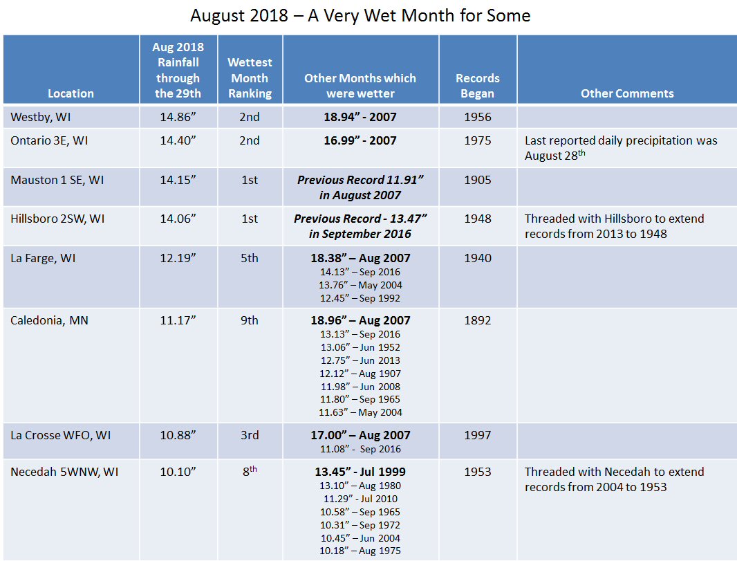
Total Rainfall August 26-29, 2018
 |
 |
|
| Regional Rainfall Totals | Local Rainfall Totals |
LOCATION                     AMOUNT

...IOWA...

...ALLAMAKEE COUNTY...
WAUKON 4SW                   3.30 IN
3 S DORCHESTER               2.75 IN
4 WNW LANSING                2.22 IN
3 SE WATERVILLE              1.82 IN

...CHICKASAW COUNTY...
NEW HAMPTON                  4.44 IN
IONIA 2W                     3.52 IN
NEW HAMPTON                  3.19 IN

...CLAYTON COUNTY...
MCGREGOR                     1.88 IN
ELKADER 6 SSW                1.00 IN
MONONA WWTP                  0.91 IN
ELKADER 6SSW                 0.66 IN
EDGEWOOD                     0.60 IN
GUTTENBERG DAM 10            0.51 IN
MARQUETTE-BLOODY RUN CREEK   0.49 IN
LITTLEPORT                   0.47 IN
VOLGA 1NE                    0.42 IN
STRAWBERRY POINT             0.35 IN
GARBER                       0.13 IN

...FAYETTE COUNTY...
ELDORADO                     2.11 IN
OELWEIN MUNICIPAL AIRPORT    0.41 IN

...FLOYD COUNTY...
CHARLES CITY                 4.42 IN
NASHUA 2SW                   2.07 IN
CHARLES CITY AIRPORT         1.65 IN

...HOWARD COUNTY...
ELMA                         3.99 IN
CRESCO 1NE                   4.74 IN
3 NE RICEVILLE               1.22 IN

...MITCHELL COUNTY...
SAINT ANSGAR                 1.48 IN
OSAGE                        0.82 IN
3 W NEW HAVEN                0.69 IN

...WINNESHIEK COUNTY...
DECORAH                      3.13 IN
BLUFFTON                     3.02 IN
5 ESE DECORAH                2.76 IN
SPILLVILLE                   2.52 IN
DECORAH MUNICIPAL AIRPORT    1.61 IN
7 ENE DECORAH                1.56 IN
CALMAR                       0.92 IN

...MINNESOTA...

...DODGE COUNTY...
HAYFIELD                     0.98 IN
2 NE KASSON                  0.24 IN

...FILLMORE COUNTY...
MABEL                        6.45 IN
HARMONY                      3.86 IN
PRESTON                      3.49 IN
LANESBORO 2NE                3.26 IN
LANESBORO-ROOT RIVER         2.66 IN
SPRING VALLEY                1.69 IN
FILLMORE                     1.57 IN

...HOUSTON COUNTY...
CALEDONIA                    9.44 IN
HOKAH                        7.60 IN
1 NNW LA CRESCENT            6.12 IN
MOUND PRAIRIE                6.10 IN
HOUSTON                      5.62 IN
YUCATAN                      5.52 IN
HOKAH 4NW                    4.95 IN
PINE CREEK                   4.10 IN

...MOWER COUNTY...
GRAND MEADOW                 2.22 IN
AUSTIN WWTP                  1.50 IN
AUSTIN 2NE-DOBBINS CREEK     1.34 IN
AUSTIN 3 NW - TURTLE CREEK   1.10 IN
LANSING-CEDAR RIVER          1.05 IN
OSTRANDER 5.1 WNW            0.83 IN
AUSTIN 3S                    0.53 IN
2 WSW MAPLEVIEW              0.38 IN

...OLMSTED COUNTY...
ROCHESTER INTERNATIONAL AIRP 1.40 IN
ROCHESTER-CASCADE CREEK      1.24 IN
5 E DOUGLAS                  1.21 IN
ELGIN 5SE                    1.21 IN
BYRON                        1.17 IN
2 NNE ROCHESTER              1.15 IN
2 ENE ROCHESTER              1.13 IN
ELGIN 2SSW                   1.10 IN
EYOTA 2NE                    1.09 IN
ROCHESTER                    1.09 IN
ROCHESTER-BELTLINE           1.06 IN
3 ESE DOUGLAS                0.99 IN
4 WSW ROCHESTER              0.99 IN
4 ESE DOUGLAS                0.90 IN
2 SE DOUGLAS                 0.87 IN
BYRON                        0.73 IN
3 SW HAMMOND                 0.73 IN
ORONOCO                      0.70 IN
ORONOCO 1W                   0.65 IN
PINE ISLAND 1S               0.44 IN

...WABASHA COUNTY...
PLAINVIEW                    1.36 IN
KELLOGG-ZUMBRO RIVER         0.65 IN
MAZEPPA 3ESE                 0.55 IN
LAKE CITY                    0.51 IN
2 NNW ZUMBRO FALLS           0.29 IN
THEILMAN 1SSW                0.25 IN

...WINONA COUNTY...
LA CRESCENT DAM 7            4.66 IN
DAKOTA                       1.99 IN
GREAT RIVER BLUFFS S.P.      1.51 IN
WINONA DAM 5A                1.43 IN
WINONA MUNICIPAL AIRPORT     1.28 IN
WINONA 4SW                   1.22 IN
BEAVER-WHITE WATER RIVER     1.21 IN
MINNESOTA CITY DAM 5         1.21 IN
WHITEWATER STATE PARK GROUP  0.97 IN
ELBA                         0.96 IN
ALTURA 5W                    0.80 IN
LEWISTON                     0.46 IN
2 NNW PICKWICK               0.43 IN
1 WSW WINONA                 0.40 IN
STOCKTON                     0.39 IN
1 ESE MINNESOTA CITY         0.34 IN

...WISCONSIN...

...ADAMS COUNTY...
1 SSW GRAND MARSH           10.57 IN
GRAND MARSH 1.9SSW           9.19 IN
OXFORD 4W                    8.90 IN
FRIENDSHIP                   4.59 IN
2 SE NEW ROME                3.18 IN
PETENWELL LAKE               3.10 IN

...BUFFALO COUNTY...
COCHRANE                     2.44 IN
ALMA DAM 4                   0.80 IN
MONDOVI                      0.31 IN

...CLARK COUNTY...
OWEN 6SSE                    2.27 IN
NEILLSVILLE 3ESE             0.83 IN

...CRAWFORD COUNTY...
LYNXVILLE DAM 9              2.17 IN
STEUBEN                      1.13 IN
PRAIRIE DU CHIEN             1.05 IN
GAYS MILLS                   0.99 IN
PRAIRIE DU CHIEN  AIRPORT    0.91 IN

...GRANT COUNTY...
FENNIMORE                    2.36 IN
1 ENE BOSCOBEL               1.63 IN
BOSCOBEL                     1.39 IN
LANCASTER                    1.02 IN
PLATTEVILLE                  0.96 IN
LANCASTER 4WSW               0.88 IN
PLATTEVILLE MUNICIPAL AIRPOR 0.78 IN
CUBA CITY                    0.69 IN

...JACKSON COUNTY...
1 E BLACK RIVER FALLS        1.27 IN
BLACK RIVER FALLS SEWAGE     1.09 IN
HATFIELD DAM                 0.38 IN
BLACK RIVER FALLS AREA AIRPO 0.34 IN

...JUNEAU COUNTY...
1 NW WISCONSIN DELLS        12.44 IN
MAUSTON 1SE                 11.40 IN
MAUSTON                      8.38 IN
NECEDAH                      5.80 IN
2 N CLOVERDALE               5.71 IN
NECEDAH 5WNW                 3.40 IN
MATHER 1SE                   2.03 IN

...LA CROSSE COUNTY...
3 W SAINT JOSEPH            11.03 IN
LA CROSSE 5.4SE              9.81 IN
LA CROSSE WEATHER OFFICE     7.48 IN
WEST SALEM                   4.97 IN
LA CROSSE 4NNW               4.83 IN
LA CROSSE REGIONAL AIRPORT   4.63 IN
MELROSE 8.2 SSW              1.84 IN
HOLMEN 2S                    1.94 IN

...MONROE COUNTY...
CASHTON 3NNW                12.86 IN
CASHTON 4.8N                11.01 IN
WILTON 4.2E                  8.58 IN
SPARTA                       5.52 IN
TOMAH RANGER STATION         5.06 IN
SPARTA/FORT MCCOY AIRPORT    4.92 IN
2 E CATARACT                 1.44 IN

...RICHLAND COUNTY...
1 SSE RICHLAND CENTER        1.96 IN
RICHLAND CENTER 4N           1.43 IN

...TAYLOR COUNTY...
MEDFORD                      1.02 IN
MEDFORD AIRPORT              0.71 IN
3 NE LUBLIN                  0.49 IN
CHELSEA                      0.34 IN

...TREMPEALEAU COUNTY...
TREMPEALEAU DAM 6            1.94 IN
1 NE GALESVILLE              1.01 IN
1 NW TREMPEALEAU             0.56 IN
ETTRICK 4WNW                 0.33 IN

...VERNON COUNTY...
WESTBY 3ENE                 12.03 IN
HILLSBORO 2SW               11.16 IN
HILLSBORO WSW               10.81 IN
ONTARIO 3E                   9.99 IN
LA FARGE                     9.75 IN
STODDARD 5NNE                9.72 IN
STODDARD                     8.90 IN
GENOA DAM 8                  5.72 IN
3 WNW VIOLA                  4.12 IN
3 WNW LA FARGE               4.10 IN
READSTOWN                    3.32 IN

OBSERVATIONS ARE COLLECTED FROM A VARIETY OF SOURCES WITH VARYING
EQUIPMENT AND EXPOSURES. WE THANK ALL VOLUNTEER WEATHER OBSERVERS
FOR THEIR DEDICATION. NOT ALL DATA LISTED ARE CONSIDERED OFFICIAL.
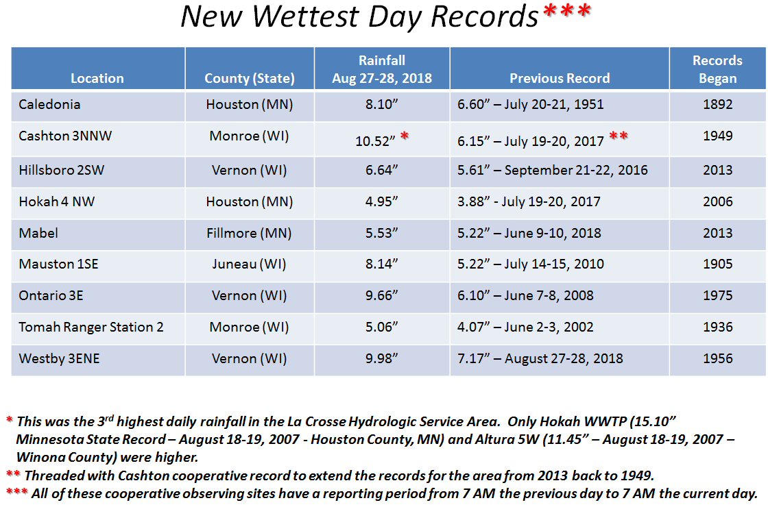
Climate Records:
 |
 |
 |
|
| Wettest Day Records | Wettest 2-Day Records | Wettest Month Records |
 |
Media use of NWS Web News Stories is encouraged! Please acknowledge the NWS as the source of any news information accessed from this site. |
|


 Weather Story
 Weather Map
 Local Radar