Temperatures:
|
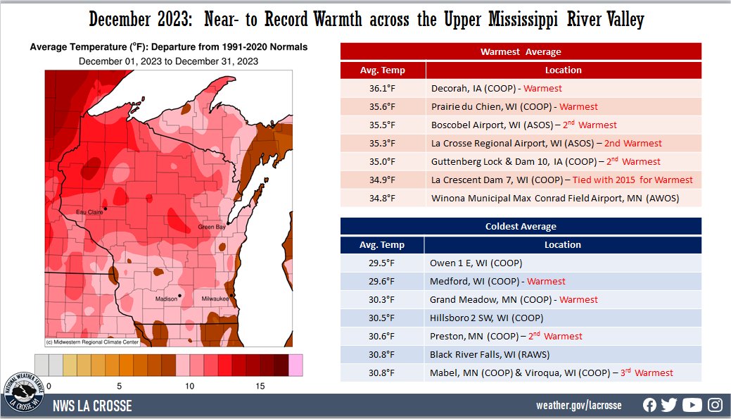
During December 2023, there was near to record warmth across the Upper Mississippi River Valley. Average temperatures ranged from 29.5°F near Owen, WI (COOP) to 36.1°F at Decorah, IA (COOP). Temperature anomalies ranged from 8°F to 13°F warmer than normal. The warmest temperature was 57°F at Boscobel Airport, WI (ASOS) on December 8. Meanwhile, the coldest temperature was 2°F at Sparta, WI on December 19.
The following locations had their warmest December…
- Decorah, IA 36.1°F - Previous record 33.8°F in 2015 - Records began in 1893
- Grand Meadow, MN 30.3°F - Previous record was 30°F in 1913 and 1923 - Records began in 1893
- La Crescent Dam, WI 34.9°F - Tied with 2015 for Warmest - Records began in 1939
- Medford, WI 29.6°F - Previous record was 29.0°F in 1923 - Records began in 1893
- Prairie du Chien, WI 35.6°F - Previous record 35.2°F in 2015 - Records began in 1893
|
 |
Precipitation:
|
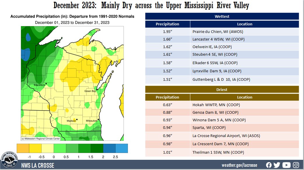
It was mainly dry across the Upper Mississippi River Valley. Precipitation varied from 0.63" at Hokah, MN (COOP) to 1.95" at Prairie du Chien, WI. Precipitation anomalies ranged from 1" drier than normal to 0.5" wetter than normal. The highest one-day precipitation was 1" at Trempealeau Dam 6, WI (COOP) from December 25 to December 26.
Abnormally dry (D0) to moderate (D1) drought continues north of Interstate 90, and abnormally dry (D0) to extreme (D3) drought lingers elsewhere.
|
 |
Snowfall:
|
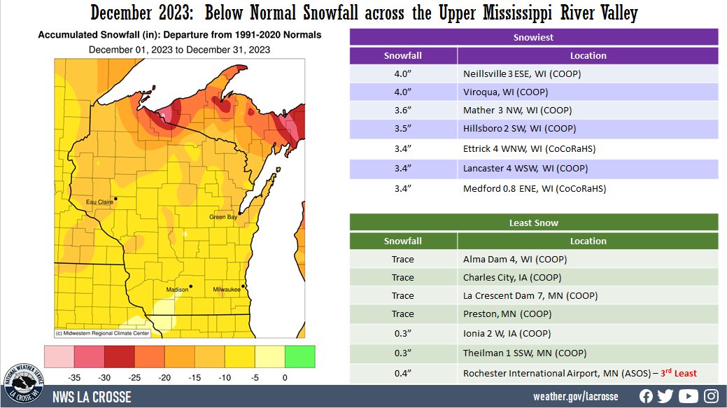
Snowfall was below normal across the Upper Mississippi River Valley. Snowfall varied from a trace of snow at Alma Dam 4, WI (COOP), Charles City, IA (COOP), La Crescent Dam 7, WI (COOP), and Preston, MN (COOP) to 4" near Neillsville, WI (COOP). Snowfall anomalies range from 5 to 15" below normal. The highest one-day snowfall was 2.8" at Viroqua, WI (COOP) from December 2 to December 3.
|
 |
The information below details December 2023 temperatures, precipitation, and snowfall for La Crosse WI, and Rochester MN.
La Crosse, WI
December 2023: Drier with Near Record Warmth in La Crosse WI
...December 2023 Highlights...
Temperatures - 2nd Warmest
- During December 2023, La Crosse Regional Airport had an average temperature of 35.3°F. This was 10.2°F warmer than the 1991-2020 normal of 25.1°F. This was the 2nd warmest. Only 1877 was warmer with an average temperature of 38.9°F.
|
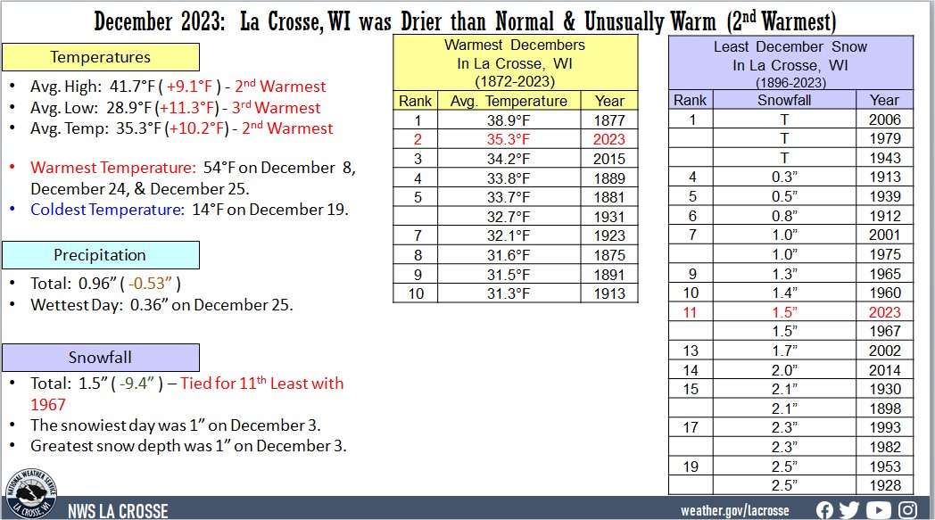 |
- Below are the ten warmest Decembers in La Crosse, WI
Warmest Decembers
in La Crosse WI
1872-2023
Average
Rank Temperature Year
---- ----------- ----
1 38.9°F 1877
2 35.3°F 2023
3 34.2°F 2015
4 33.8°F 1889
5 33.7°F 1881
6 32.7°F 1931
7 32.1°F 1923
8 31.6°F 1875
9 31.5°F 1891
10 31.3°F 1913
- The average high temperature was 41.7°F. This was 9.1°F warmer than the 1991-2020 normal of 32.6°F. This was the 2nd warmest. Only 1877 was warmer with an average temperature of 44°F.
- The average low temperature was 28.9°F. This was 11.3°F warmer than the 1991-2020 normal of 17.6°F. This was the 3rd warmest. Only 1877 (33.9°F) and 2015 (29.1°F) were warmer.
- The warmest high temperature was 54°F on the 8th, 24th, and 25th. There were 6 days in which the high temperature was 50°F or higher. This was tied with 1875 and 1941 for the 4th most in December. The most was 8 days in 1877, 1939, and 1998.
- The coldest high temperature was 32°F on the 10th. This is the only December in which every day had a high temperature of 32°F or greater.
- The warmest low temperature was 50°F on the 25th. This was tied for the 2nd warmest December low temperature with December 22, 1877, and December 4, 2000. Only December 2, 1982, was warmer at 51°F.
- The coldest low temperature was 14°F on the 19th. Only 1 December (19°F in 1877) had its coldest low temperature warmer than this.
Precipitation - Drier than Normal
- A total of 0.96 inches of precipitation fell. This was 0.53" drier than the 1991-2020 normal of 1.49".
- The wettest December day was 0.36" on December 25. This was the 6th wettest Christmas.
- Precipitation fell on 16 days (51.6%).
- Measurable precipitation fell on 7 days (22.6%) and a trace of precipitation fell on another 9 days (29%).
Snowfall - Tied for 11th Least
- A total of 1.5" of snow fell. This was 9.4" below the 1991-2020 normal of 10.9 inches. This was tied with 1967 for the 11th least and the least since 2006 (tied with 1943 and 1979 for the least December snowfall). Below is the 20 least December snowfall.
Snowless Decembers
in La Crosse WI
1896-2023
Rank Snowfall Year
---- -------- ----
1 Trace 2006
Trace 1979
Trace 1943
4 0.3 inches 1913
5 0.5 inches 1939
6 0.8 inches 1912
7 1.0 inch 2001
1.0 inch 1975
9 1.3 inches 1965
10 1.4 inches 1960
11 1.5 inches 2023
1.5 inches 1967
13 1.7 inches 2002
14 2.0 inches 2014
15 2.1 inches 1930
2.1 inches 1898
17 2.3 inches 1993
2.3 inches 1982
19 2.5 inches 1953
2.5 inches 1928
- The snowiest day was 1" on December 3.
- Snow fell on 8 days (25.8%). Measurable snow fell on 2 days (6.5%) and a trace of snow fell on another 6 days (19.4%).
Snow Depth - Tied for the Least
- The average December snow depth was 0". This was 2.9 inches below the 1892-2023 average of 2.9 inches. This was tied with 1912, 1913, 1939, 1943, 1979, 1982, and 2006 for least.
- Snow was on the ground for 4 days (12.9%). There was measurable snow on 1 day (long-term average in 18 days) and a trace amount on another 3 days (long-term average in 4 days).
- The greatest snow depth was 1" on December 3.
...Records...
- Daily
- December 24 - Warm Low of 41°F - Tied with 1893 and 1936
- December 24 - Highest Dew Point of 52°F - Previous record was 42°F in 2021
- December 25 - Warm Low of 50°F - Previous Record 46°F in 1936
- December 25 - Highest Dew Point of 52°F - Previous record was 42°F in 1982
...Looking ahead to January...
- The normal high temperatures in La Crosse range from 27 to 28°F. The coldest normal high temperatures occur from January 8 through January 27. The normal low temperatures range from 10 to 13°F. The coldest low temperatures occur from January 13 through the end of the month. The warmest January temperature on record is 57°F on January 3, 1874, January 1, 1897, and January 25, 1981, and the coldest temperature is -43°F on January 18, 1873.
- The normal mean temperature for January is 18.9°F. La Crosse’s warmest January occurred in 1880 with an average temperature of 32°F, and their coldest January occurred in 1912 with an average temperature of -1.1°F (coldest month ever recorded).
- The normal January precipitation is 1.25". The wettest January occurred in 1886 with 3.44" of precipitation and the driest January occurred in 1948 and 1981 with just 0.14". The wettest January day occurred on January 5, 1946, when 1.67" of precipitation fell.
- The normal January snowfall is 11.8" (snowiest month). The snowiest January occurred in 1929 with 39.6" of snow (snowiest month ever recorded) and the least snow was 1.6" in 1903 and 2006. The snowiest January day occurred on January 26, 1996, when 12" of snow fell.
Rochester
December 2023: Slightly Drier with Record Warmth in Rochester MN
...December 2023 Highlights...
Temperatures - Warmest
- During December 2023, Rochester International Airport had an average temperature of 31.8°F. This was 11°F warmer than the 1991-2020 normal of 20.8°F. This was the warmest December. The previous record was 30.7°F in 1931.
|
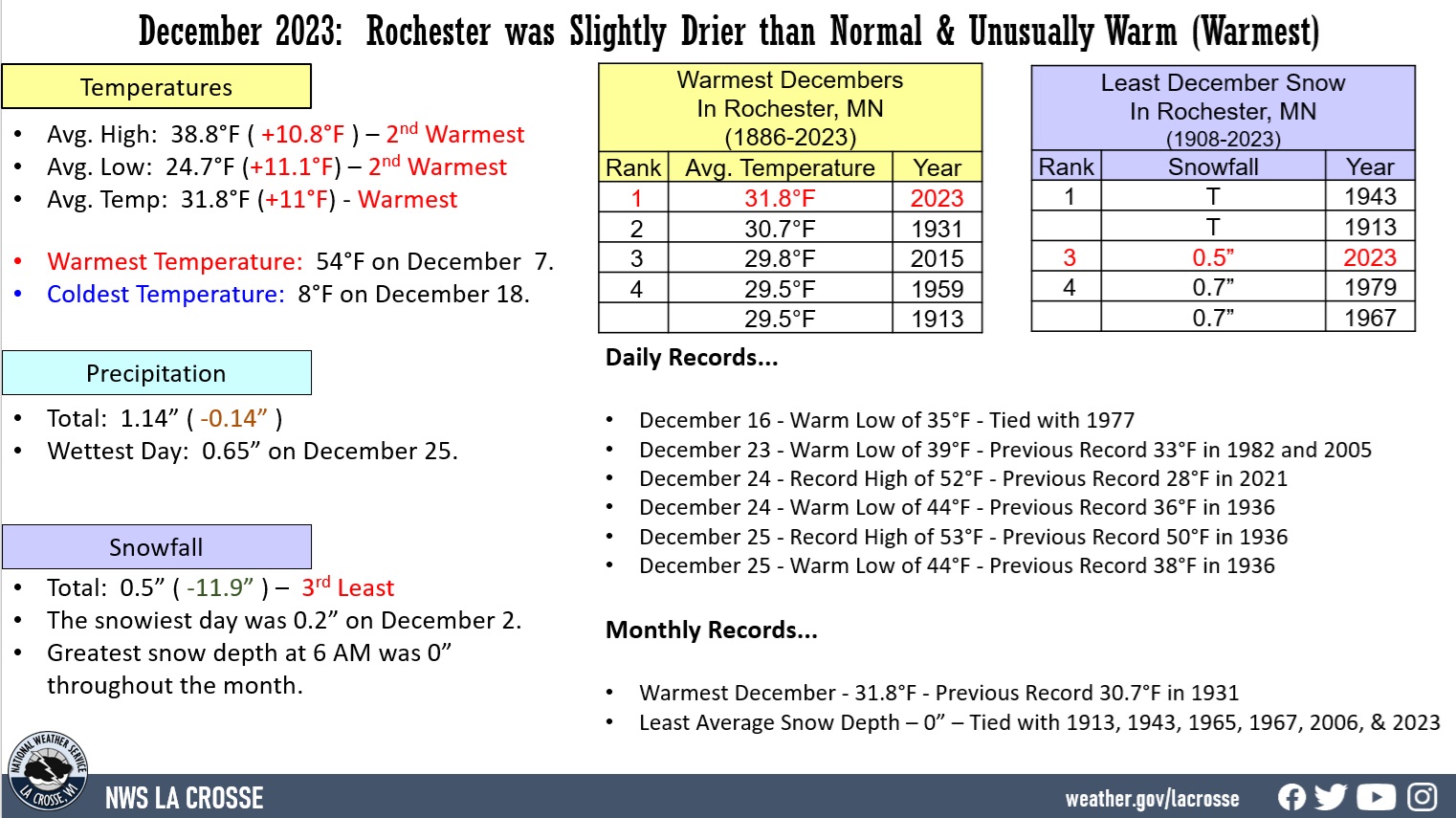 |
- Below are the ten warmest Decembers in Rochester, MN.
Warmest Decembers
in Rochester MN
1886-2023
Average
Rank Temperature Year
---- ----------- ----
1 31.8°F 2023
2 30.7°F 1931
3 29.8°F 2015
4 29.5°F 1959
29.5°F 1913
6 29.0°F 2006
7 28.5°F 1965
8 26.6°F 1941
9 26.4°F 2001
10 26.1°F 2011
26.1°F 1982
- The average high temperature was 38.8°F. This was 10.8°F warmer than the 1991-2020 normal of 28°F. The only 1913 was warmer with an average of 38.9°F.
- The average low temperature was 24.7°F. This was 11.1°F warmer than the 1991-2020 normal of 13.6°F. This was the 2nd warmest. Only 2015 was warmer with an average of 24.8°F.
- The warmest high temperature was 54°F on December 7. The high temperature was 50°F or warmer on 5 days. Only 3 Decembers had more. They were 1998 and 1939 with 7 days and 1913 with 6 days.
- The coldest high temperature was 24°F on December 10. The high temperature was 32°F or warmer on 25 of the 31 days. This was tied with 2006 for the 2nd most. The only December with more was 1931 with 28 days.
- The warmest low temperature was 44°F on December 24 and December 25. Both of these set record-warm lows for their respective dates.
- The coldest low temperature was 8°F on December 18. There were only 2 days in which the low temperature fell below 10°F. This was tied with 1931 and 1965 for the 3rd least. Only 1908 and 1959 had less (1 day).
Precipitation - Slightly Drier than Normal
- A total of 1.14" of precipitation fell. This was 0.14" drier than the 1991-2020 normal of 1.28".
- The wettest December day was 0.65" on December 25. This was tied with 1945 for the 2nd wettest Christmas. Only 1893 was wetter with 0.75".
- Precipitation fell on 15 days (48.4%). Measurable precipitation fell on 8 days (25.8%) and a trace of precipitation fell on another 7 days (22.6%).
Snowfall - 3rd Least
- A total of 0.5" of snow fell. This was 11.9" below the 1991-2020 normal of 12.4". This was the 3rd least and the least since 1943 (a trace of snow - tied with 1913 for the least December snowfall).
- Below is the 10 least December snowfall.
Snowless Decembers
in Rochester MN
1908-2023
Rank Snowfall Year
---- -------- ----
1 Trace 1943
Trace 1913
3 0.5 inches 2023
4 0.7 inches 1979
0.7 inches 1967
6 0.8 inches 2006
7 0.9 inches 1965
8 1.6 inches 2002
9 1.9 inches 1975
10 2.0 inches 1960
2.0 inches 1928
- The snowiest day was 0.2" on December 2.
- Snow fell on 10 days (32.3%). Measurable snow fell on 3 days (9.7%) and a trace of snow fell on another 7 days (22.6%).
Snow Depth - Below Normal
- The average December snow depth was 0". This was 3.5 inches below the 1913-2023 average of 3.5". This was tied with 1913, 1943, 1965, 1967, and 2006 for least average snow depth.
- The greatest snow depth was 0" throughout the month.
...Records...
- Daily
- December 16 - Warm Low of 35°F - Tied with 1977
- December 23 - Warm Low of 39°F - Previous Record 33°F in 1982 and 2005
- December 24 - Record High of 52°F - Previous Record 28°F in 2021
- December 24 - Warm Low of 44°F - Previous Record 36°F in 1936
- December 24 - Highest Dew Point of 52°F - Previous record was 41°F in 2021
- December 25 - Record High of 53°F - Previous Record 50°F in 1936
- December 25 - Warm Low of 44°F - Previous Record 38°F in 1936
- December 25 - Highest Dew Point of 52°F - Previous record was 37°F in 2016
- Monthly
- Warmest December - 31.8°F - Previous Record 30.7°F in 1931
- Least Average Snow Depth – 0” – Tied with 1913, 1943, 1965, 1967, and 2006
...Looking ahead to January...
- The normal high temperatures in Rochester range from 22 to 24°F. The coldest normal high temperatures occur from January 10 through January 26. The normal low temperatures range from 6 to 9°F. The coldest low temperatures occur from January 18 through January 30. The warmest January temperature on record was 58°F on January 25, 1944, and the coldest temperature was -42°F on January 7, 1887.
- The normal mean temperature for January is 14.7°F (coldest month). Rochester’s warmest January occurred in 2006 with an average temperature of 28.1°F, and their coldest January occurred in 1912 with an average temperature of -3.8°F (coldest month ever recorded).
- The normal January precipitation is 0.99" (driest month on average). The wettest January occurred in 1888 with 2.92" of precipitation and the driest January occurred in 1961 with just 0.07". The wettest January day occurred on January 6, 1888, when 1.50" of precipitation fell.
- The normal January snowfall is 12.2" (2nd snowiest month on average). The snowiest January occurred in 1996 with 30.2" of snow and the least snow was 0.8" in 2006. The snowiest January day occurred on January 22, 1982, when 15.4" of snow fell.


 Weather Story
 Weather Map
 Local Radar