Overview
|
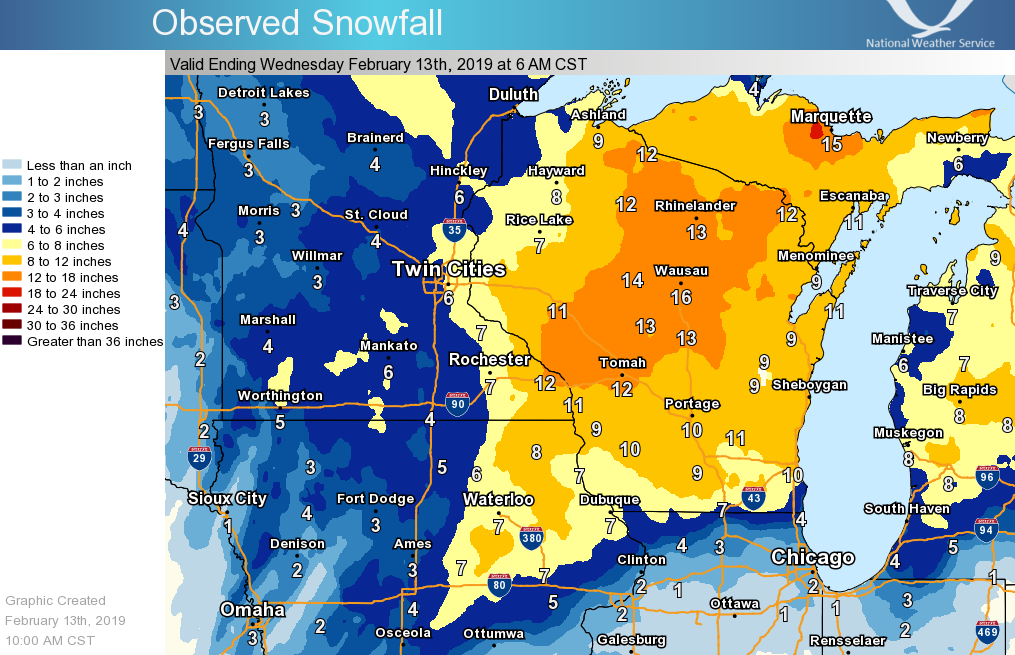
A storm system brought snow into the area from Monday evening, February 11th, and continued through late Tuesday evening, February 12th, with remnant light snow that fell through the early morning hours of Wednesday, February 13. Snow became heavy in northeast Iowa first and then spread northward overnight into Tuesday morning. As the storm pivoted over the area, it produced bands of heavier snow from northeast Iowa and southeast Minnesota into western Wisconsin. Totals ranged from 8-15", especially from near Winona, MN to Black River Falls, WI. Behind the snow, northwest winds increased and caused blowing and drifting in open farm land by Tuesday evening. This ended up causing more slick roads and hazardous travel - even some highways were closed in southern Minnesota and northern Iowa. |
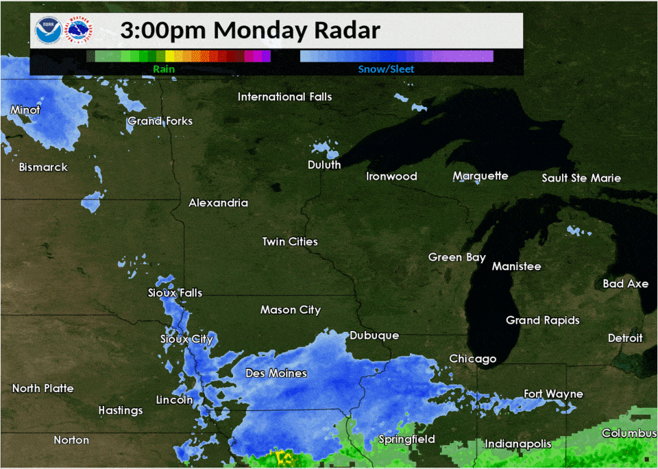 Radar loop showing the snow moving in and pivoting over the area on February 11th and 12th. |
Wind Reports:
... 24 HOUR PEAK WIND REPORTS...

Location                     Speed     Time/Date       Lat/Lon
Charles City Airport         46 MPH    0335 PM 02/12   43.07N/92.61W
Rochester International Airp 44 MPH    0445 PM 02/12   43.91N/92.50W
Byron                        40 MPH    0400 PM 02/12   44.04N/92.64W
2 W Oelwein                  40 MPH    0655 PM 02/12   42.68N/91.97W
Oelwein Municipal Airport    40 MPH    0655 PM 02/12   42.68N/91.97W
2 N Ionia                    40 MPH    0820 PM 02/12   43.07N/92.46W
La Crosse Regional Airport   39 MPH    0712 PM 02/12   43.88N/91.26W
1 ENE Dexter                 39 MPH    0805 PM 02/12   43.73N/92.68W
3 N Stewartville             39 MPH    0405 PM 02/12   43.90N/92.48W
Austin Municipal Airport     38 MPH    0436 PM 02/12   43.66N/92.93W
Platteville Municipal Airpor 38 MPH    1015 PM 02/12   42.69N/90.44W
Mayo Helipad                 37 MPH    0656 PM 02/12   44.02N/92.48W
3 NE Riceville               37 MPH    0530 PM 02/12   43.40N/92.50W
Preston Airport              37 MPH    0455 PM 02/12   43.68N/92.18W
2 SE Eyota                   37 MPH    0545 PM 02/12   43.96N/92.21W
Boscobel Airport             37 MPH    0423 PM 02/12   43.16N/90.67W
Prairie Du Chien  Airport    37 MPH    0815 PM 02/12   43.02N/91.12W
5 NW Frankville              37 MPH    0751 PM 02/12   43.25N/91.70W
2 E Kasson                   36 MPH    0645 PM 02/12   44.02N/92.71W
1 SSE Kellogg                35 MPH    0645 PM 02/12   44.28N/91.99W
Volk Field                   35 MPH    1058 PM 02/12   43.94N/90.25W
1 E Ridgeway                 34 MPH    0820 PM 02/12   43.91N/91.54W
2 NNW Zumbro Falls           33 MPH    0913 PM 02/12   44.32N/92.44W
2 SE Douglas                 33 MPH    0331 PM 02/12   44.08N/92.55W
Decorah Municipal Airport    33 MPH    0815 PM 02/12   43.28N/91.74W
2 ESE Canton                 33 MPH    0245 PM 02/12   43.51N/91.88W
Dodge Center Airport         33 MPH    0556 PM 02/12   44.02N/92.83W
3 W Saint Joseph             32 MPH    0809 PM 02/12   43.78N/91.10W
Viroqua Municipal Airport    31 MPH    0915 PM 02/12   43.58N/90.90W
Mauston Airport              30 MPH    1155 PM 02/12   43.84N/90.14W
Sparta/Fort McCoy Airport    28 MPH    0935 PM 02/12   43.96N/90.74W
Necedah                      28 MPH    1048 PM 02/12   44.03N/90.08W
1 ENE Boscobel               27 MPH    1203 AM 02/13   43.15N/90.68W
2 NNE Rochester              27 MPH    0645 PM 02/12   44.05N/92.45W
Lake City                    26 MPH    0617 PM 02/12   44.45N/92.27W
3 NE Lublin                  25 MPH    0814 PM 02/12   45.11N/90.69W
Medford Airport              25 MPH    0935 PM 02/12   45.10N/90.30W
1 WSW Onalaska               24 MPH    0750 PM 02/12   43.88N/91.23W
Black River Falls Area Airpo 23 MPH    0955 PM 02/12   44.25N/90.86W
1 E Black River Falls        23 MPH    0915 PM 02/12   44.30N/90.83W
Monona                       22 MPH    0709 PM 02/12   43.04N/91.39W
2 E Cataract                 21 MPH    0853 PM 02/12   44.09N/90.79W
De Soto                      21 MPH    0741 PM 02/12   43.42N/91.19W
Hayfield                     21 MPH    0717 PM 02/12   43.89N/92.85W
Decorah                      20 MPH    0910 PM 02/12   43.30N/91.79W

Observations are collected from a variety of sources with varying
equipment and exposures. We thank all volunteer weather observers
for their dedication. Not all data listed are considered official.
Snow Reports
 |
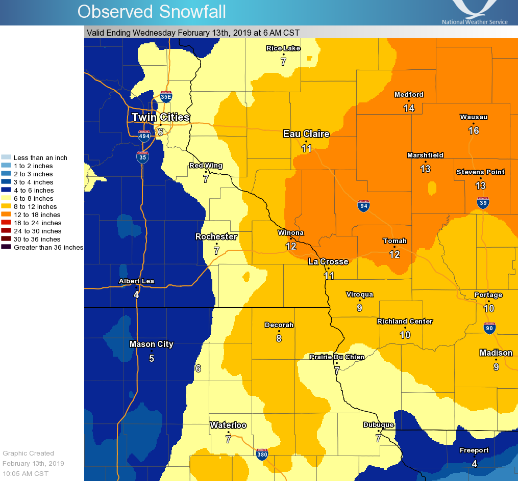 |
| Regional Snowfall Totals Feb.11-13 (Click to enlarge) |
Snowfall Totals Feb.11-13 (Click to enlarge) |
Record daily snowfall amounts were set for some locations over the area for February 12th,
including at Rochester, MN (5.7") and at La Crosse (9.0")


LOCATION                     AMOUNT    TIME/DATE       LAT/LON

...IOWA...

...ALLAMAKEE COUNTY...
2 N DORCHESTER               11.5 IN   0300 PM 02/12
LANSING                      10.0 IN   0408 PM 02/12
5 NE POSTVILLE               7.3 IN    0700 AM 02/13   43.14N/91.49W

...CHICKASAW COUNTY...
NEW HAMPTON                  8.0 IN    0800 AM 02/13   43.06N/92.31W
2 W IONIA                    7.0 IN    0700 AM 02/13

...CLAYTON COUNTY...
STRAWBERRY POINT             9.6 IN    0700 AM 02/13
VOLGA 1NE                    8.7 IN    0619 AM 02/13   42.81N/91.52W
ELKADER                      8.0 IN    0700 AM 02/13
ELKADER 6SSW                 7.6 IN    0700 AM 02/13   42.78N/91.45W
GUTTENBERG DAM 10            7.1 IN    0800 AM 02/13   42.78N/91.10W

...FAYETTE COUNTY...
FAYETTE                      8.5 IN    0645 AM 02/13   42.85N/91.82W
WADENA                       8.0 IN    0700 AM 02/13
1 SSW WEST UNION             8.0 IN    0700 AM 02/13

...FLOYD COUNTY...
CHARLES CITY                 6.0 IN    0700 AM 02/13   43.06N/92.67W
MARBLE ROCK                  5.0 IN    0743 PM 02/12

...HOWARD COUNTY...
CRESCO 1NE                   8.8 IN    0725 AM 02/13   43.39N/92.09W

...MITCHELL COUNTY...
RICEVILLE                    5.0 IN    1042 AM 02/12
ST ANSGAR                    4.2 IN    0630 AM 02/13
OSAGE                        4.0 IN    0700 AM 02/13   43.28N/92.81W

...WINNESHIEK COUNTY...
7 ENE DECORAH                9.5 IN    0730 AM 02/13   43.34N/91.64W
SPILLVILLE                   9.0 IN    0200 PM 02/12
6 E BLUFFTON                 7.5 IN    0844 AM 02/12

...MINNESOTA...

...DODGE COUNTY...
2 NE KASSON                  5.8 IN    0700 AM 02/13   44.05N/92.72W
MANTORVILLE                  5.0 IN    0856 PM 02/12   44.07N/92.76W
1 SE MANTORVILLE             5.0 IN    1109 AM 02/12

...FILLMORE COUNTY...
CHATFIELD                    9.0 IN    0152 PM 02/12
RUSHFORD                     9.0 IN    0832 AM 02/12
1 S PETERSON                 8.9 IN    0800 AM 02/13   43.77N/91.83W
MABEL                        7.5 IN    0645 AM 02/13   43.52N/91.76W
PRESTON                      7.3 IN    0819 AM 02/13   43.67N/92.07W
1 SSE PILOT MOUND            6.8 IN    0700 AM 02/13   43.79N/92.03W

...HOUSTON COUNTY...
CALEDONIA                    14.5 IN   0708 PM 02/12   43.63N/91.50W
SPRING GROVE                 13.8 IN   0420 PM 02/12   43.56N/91.64W
3 W STODDARD WI              10.8 IN   0800 AM 02/12
1 S HOUSTON                  10.0 IN   0903 AM 02/12
1 W BROWNSVILLE              10.0 IN   0801 AM 02/12
4 NW EITZEN                  9.5 IN    0800 AM 02/13   43.56N/91.51W
2 NE MOUND PRAIRIE           9.1 IN    1030 AM 02/12
1 W LA CRESCENT              9.0 IN    1025 AM 02/12

...MOWER COUNTY...
2 NE LANSING                 4.5 IN    1019 AM 02/12
4 WSW AUSTIN                 4.5 IN    0946 AM 02/12
1 ENE AUSTIN                 4.0 IN    0800 AM 02/12
AUSTIN                       3.5 IN    0501 AM 02/12

...OLMSTED COUNTY...
2 S PREDMORE                 7.8 IN    0330 PM 02/12   43.91N/92.34W
4 ESE DOUGLAS                7.8 IN    0130 PM 02/12
1 SSW ROCHESTER              7.5 IN    1207 PM 02/12
ELGIN 2SSW                   7.5 IN    0700 AM 02/13   44.10N/92.27W
ROCHESTER INTL AIRPORT       7.1 IN    0600 AM 02/13   43.91N/92.50W
1 SE ROCHESTER               7.0 IN    0750 AM 02/12
2 NE ROCHESTER               6.8 IN    0600 AM 02/13   44.04N/92.44W
BYRON                        6.5 IN    0203 PM 02/12
DOVER                        6.5 IN    1011 AM 02/12

...WABASHA COUNTY...
1 N WABASHA                  10.5 IN   0907 PM 02/12   44.38N/92.04W
2 WSW KELLOGG                10.0 IN   0645 PM 02/12   44.30N/92.05W
THEILMAN 1SSW                8.5 IN    0730 AM 02/13   44.28N/92.19W

...WINONA COUNTY...
1 ESE GOODVIEW               14.5 IN   0600 PM 02/12   44.06N/91.69W
LEWISTON                     12.0 IN   0312 PM 02/12
LA CRESCENT DAM 7            12.0 IN   0800 AM 02/13   43.87N/91.31W
MINNESOTA CITY DAM 5         12.0 IN   0800 AM 02/13   44.16N/91.81W
WINONA                       11.8 IN   0432 PM 02/12   44.05N/91.66W
1 N PICKWICK                 11.5 IN   0153 PM 02/12
WINONA 4SW                   11.0 IN   0758 PM 02/12   43.98N/91.71W
2 SE WINONA                  11.0 IN   0525 PM 02/12   44.03N/91.63W
ALTURA 5W                    7.5 IN    0700 AM 02/13   44.06N/92.04W

...WISCONSIN...

...ADAMS COUNTY...
FRIENDSHIP                   11.9 IN   0700 AM 02/13   43.98N/89.83W
3 ESE WHITE CREEK            10.5 IN   0952 AM 02/12
6 ESE NEW ROME               7.8 IN    0924 AM 02/12

...BUFFALO COUNTY...
ALMA DAM 4                   16.0 IN   0800 AM 02/13   44.33N/91.92W
7 NW URNE                    8.0 IN    1226 PM 02/12
NELSON                       6.0 IN    1224 PM 02/12

...CLARK COUNTY...
LOYAL                        17.4 IN   0105 AM 02/13   44.73N/90.49W
3 SW SPENCER                 13.5 IN   0927 AM 02/13   44.71N/90.34W
WITHEE                       13.5 IN   0438 PM 02/12   44.95N/90.60W
NEILLSVILLE                  10.5 IN   1045 AM 02/12

...CRAWFORD COUNTY...
DE SOTO 1SE                  12.5 IN   0600 AM 02/13   43.42N/91.19W
2 N PRAIRIE DU CHIEN         8.7 IN    0744 PM 02/12   43.07N/91.14W
1 NNW PRAIRIE DU CHIEN       8.0 IN    0903 AM 02/12
1 SE DESOTO                  8.0 IN    0700 AM 02/12
LYNXVILLE DAM 9              8.0 IN    0800 AM 02/13   43.21N/91.10W
PRAIRIE DU CHIEN             7.0 IN    0700 AM 02/13   43.05N/91.13W
STEUBEN 4SE                  6.8 IN    0700 AM 02/13   43.13N/90.84W

...GRANT COUNTY...
WOODMAN                      7.2 IN    0410 PM 02/12   43.09N/90.80W
1 W PLATTEVILLE              7.0 IN    0744 AM 02/12
CUBA CITY                    6.5 IN    0800 AM 02/13   42.60N/90.43W
4 WSW LANCASTER              6.4 IN    0800 AM 02/13

...JACKSON COUNTY...
HATFIELD                     14.8 IN   0903 PM 02/12   44.41N/90.73W
MILLSTON                     13.5 IN   0137 PM 02/12
5 E IRVING                   11.0 IN   0611 PM 02/12   44.19N/90.80W
BLACK RIVER FALLS            10.5 IN   0925 AM 02/12

...JUNEAU COUNTY...
2 WSW BUCKHORN STATE PARK    13.0 IN   0830 AM 02/12
MAUSTON 1SE                  12.0 IN   0800 AM 02/13   43.79N/90.06W
1 WNW CAMP DOUGLAS           11.5 IN   0102 PM 02/12
3 SSE NECEDAH                9.5 IN    1258 PM 02/12

...LA CROSSE COUNTY...
MINDORO                      14.0 IN   0526 PM 02/12   44.02N/91.10W
1 WSW WEST SALEM             13.9 IN   0700 AM 02/13   43.90N/91.10W
ONALASKA                     13.0 IN   0557 PM 02/12   43.89N/91.22W
1 SW BARRE MILLS             12.5 IN   0700 AM 02/13   43.82N/91.13W
3 W SAINT JOSEPH             12.5 IN   0700 AM 02/13   43.78N/91.10W
2 SSE HOLMEN                 12.3 IN   0700 AM 02/13
4 SSE LA CROSSE              12.2 IN   1000 PM 02/12   43.77N/91.22W
HOLMEN                       12.0 IN   0230 PM 02/12
LA CROSSE 4NNW               11.1 IN   0730 AM 02/13   43.87N/91.27W
LA CROSSE REGIONAL AIRPORT   11.0 IN   0600 AM 02/12   43.88N/91.26W
LA CROSSE WEATHER OFFICE     10.2 IN   0600 AM 02/13   43.82N/91.19W
5 SSE LA CROSSE              9.2 IN    0730 PM 02/12   43.75N/91.19W

...MONROE COUNTY...
2 SE TUNNEL CITY             18.5 IN   0732 PM 02/12   43.99N/90.54W
TOMAH                        17.6 IN   0500 PM 02/12   43.99N/90.50W
WARRENS 4WSW                 17.5 IN   0700 AM 02/13   44.10N/90.59W
1 S SPARTA                   14.5 IN   0553 PM 02/12   43.93N/90.81W
KENDALL                      14.0 IN   0430 PM 02/12   43.79N/90.37W
1 NNE TOMAH                  14.0 IN   1143 AM 02/12
4 S SPARTA                   13.0 IN   0700 AM 02/13
OAKDALE                      13.0 IN   0152 PM 02/12
1 SSW TOMAH                  12.5 IN   0438 PM 02/12   43.97N/90.51W
SPARTA                       12.0 IN   0255 PM 02/12
1 SSW TOMAH                  11.8 IN   0437 PM 02/12
CASHTON 3NNW                 11.5 IN   0725 AM 02/13   43.79N/90.80W
3 S SPARTA                   11.0 IN   0505 PM 02/12

...RICHLAND COUNTY...
RICHLAND CENTER 4N           9.0 IN    0700 AM 02/13   43.40N/90.39W
RICHLAND CENTER              9.0 IN    0910 AM 02/12
GILLINGHAM                   8.0 IN    0200 PM 02/12

...TAYLOR COUNTY...
MEDFORD                      12.0 IN   0800 AM 02/13   45.13N/90.34W
2 N DORCHESTER               11.7 IN   0357 PM 02/12   45.04N/90.34W

...TREMPEALEAU COUNTY...
INDEPENDENCE                 20.0 IN   1000 PM 02/12   44.36N/91.42W
BLAIR                        18.8 IN   0659 PM 02/12   44.30N/91.23W
ARCADIA                      18.0 IN   0630 PM 02/12   44.25N/91.49W
3 NNW FRENCHVILLE            15.5 IN   0441 PM 02/12   44.19N/91.34W
WHITEHALL                    15.0 IN   0312 PM 02/12
3 SSE ELK CREEK              13.0 IN   0215 PM 02/12
2 WSW GALESVILLE             12.2 IN   0239 PM 02/12
OSSEO                        12.0 IN   0700 AM 02/13   44.58N/91.22W
TREMPEALEAU                  11.5 IN   0925 AM 02/12
TREMPEALEAU DAM 6            11.0 IN   0700 AM 02/12

...VERNON COUNTY...
VIROQUA 0.8 ESE              12.4 IN   0700 AM 02/13   43.55N/90.87W
VIROQUA                      9.9 IN    0700 AM 02/13   43.56N/90.88W
STODDARD 5NNE                9.1 IN    0700 AM 02/13   43.72N/91.17W
3 NE STODDARD                9.0 IN    0530 PM 02/12
HILLSBORO 2SW                9.0 IN    0700 AM 02/13   43.63N/90.38W
STODDARD                     8.8 IN    0700 AM 02/13   43.66N/91.22W
LA FARGE                     8.5 IN    0700 AM 02/12
GENOA DAM 8                  8.0 IN    0800 AM 02/13   43.57N/91.23W
WESTBY 3ENE                  6.5 IN    0700 AM 02/13   43.67N/90.81W

OBSERVATIONS ARE COLLECTED FROM A VARIETY OF SOURCES WITH VARYING
EQUIPMENT AND EXPOSURES. WE THANK ALL VOLUNTEER WEATHER OBSERVERS
FOR THEIR DEDICATION. NOT ALL DATA LISTED ARE CONSIDERED OFFICIAL.
Services:
 |
 |
||
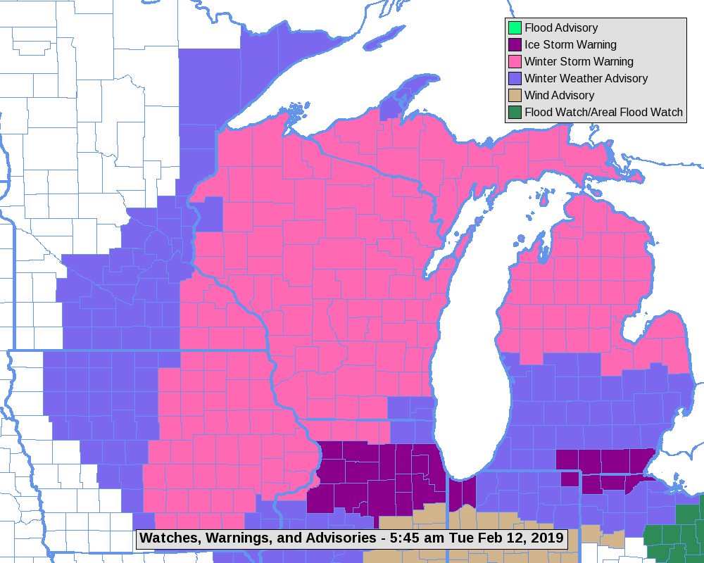
| Warnings and Advisories that were in effect for the storm |
Graphicast issued February 12th |
Photos:
 |
 |
 |
 |
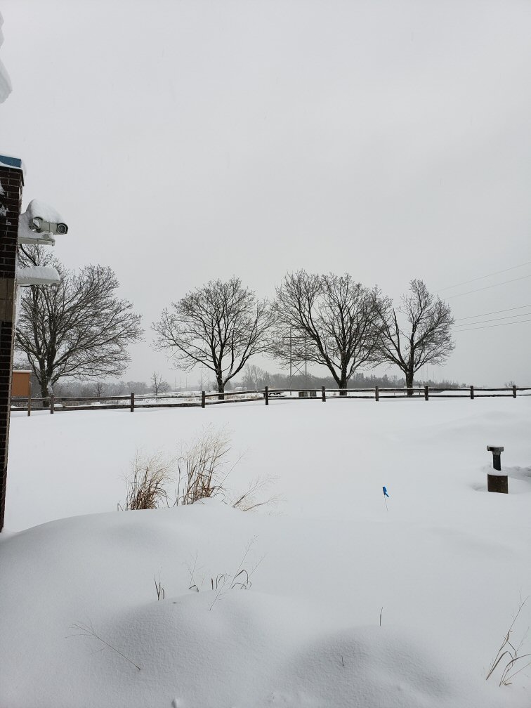
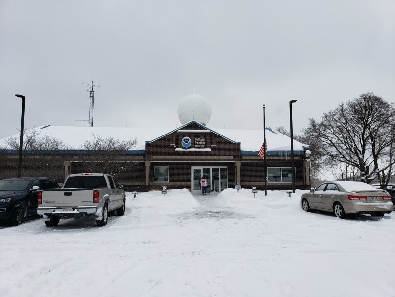
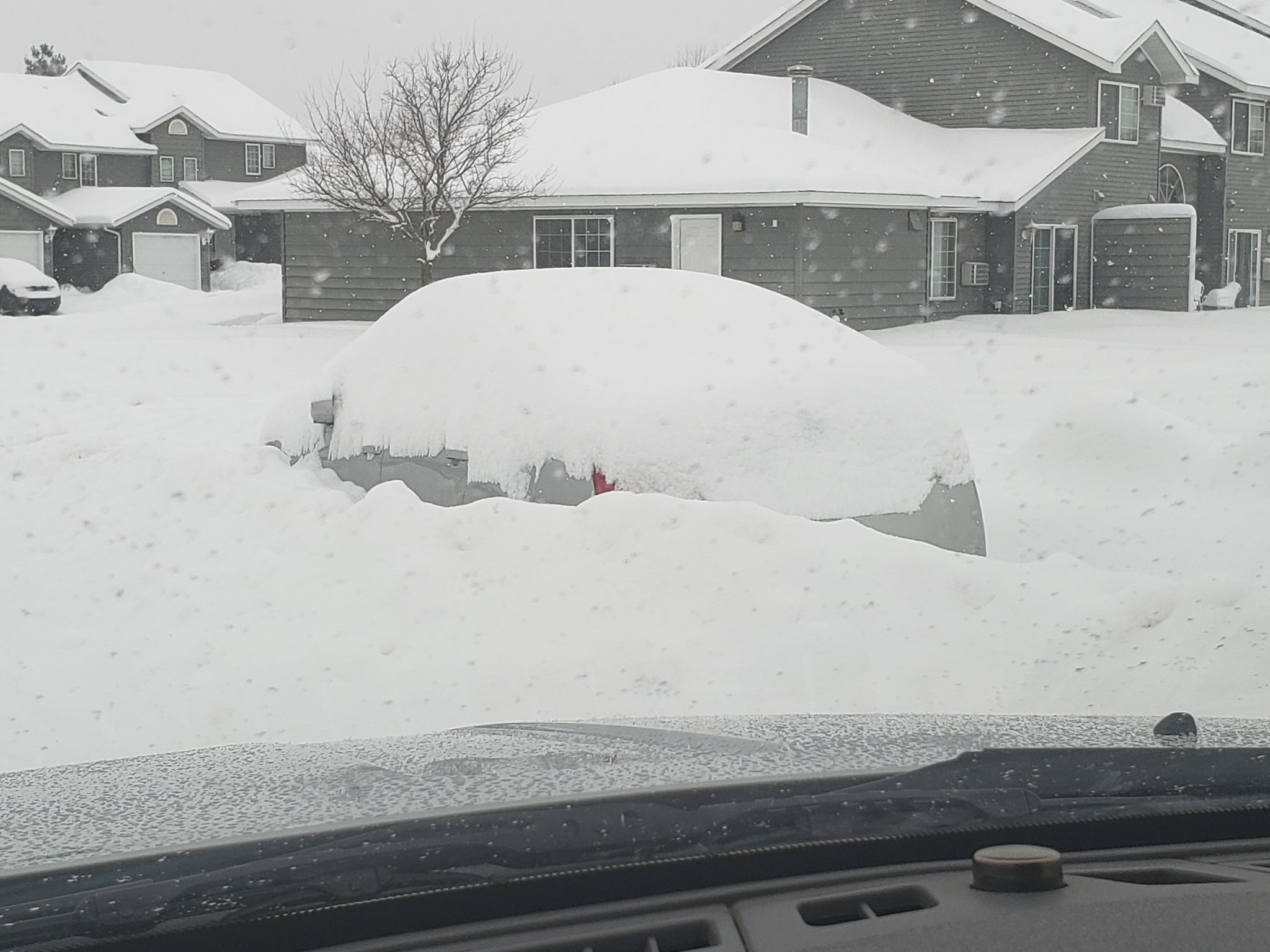
| Snow at NWS La Crosse | Snow at NWS La Crosse | Rochester, MN (Photo by David Springer Jr.) |
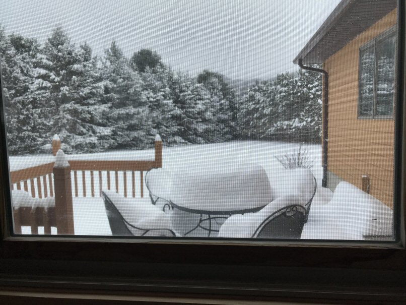
Near Winona, MN (Photo by Dan Goltz) |
 |
Media use of NWS Web News Stories is encouraged! Please acknowledge the NWS as the source of any news information accessed from this site. |
|


 Weather Story
 Weather Map
 Local Radar