|
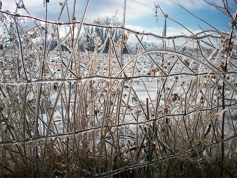
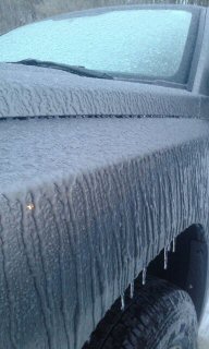
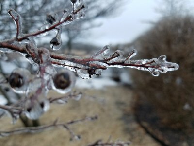
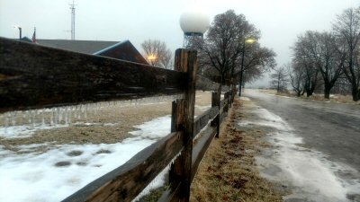
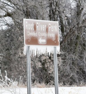
Overview A prolonged period of freezing drizzle and/or freezing rain produced icing in most areas on February 19th and 20th. Conditions were worst in southeast Minnesota where some areas received 1/4 to 1/2 inch of ice, sleet, and even some snow. Main roads were just wet but less traveled roads, parking lots, and sidewalks were covered in a layer of ice. The ice led to numerous accidents and difficult travel. Most area schools were closed on Tuesday, February 20th. The National Weather Service had a long period of Winter Weather Advisories in effect. In addition, rainfall of 0.50 to 1.00" led to ponding of water and even some river flooding, especially in southwest Wisconsin, where the Grant and Platte Rivers rose above flood stage for a time. |
 |
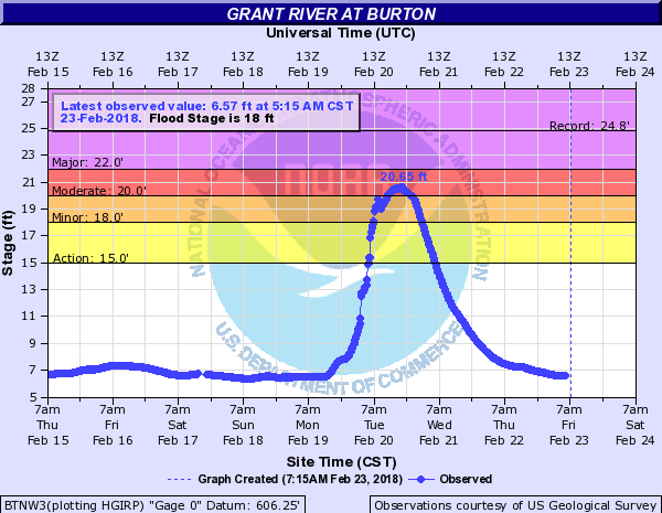
Flooding
Rainfall of 0.50" to 1.00" on top of frozen ground led to rises on several rivers and creeks in eastern Iowa and southern Wisconsin.
Hydrographs
 |
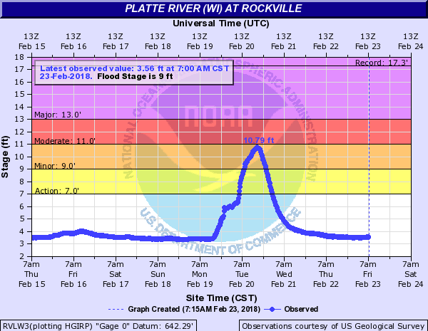 |
| Grant River at Burton, WI | Platte River at Rockville, WI |
Service
YouTube briefing videos:
Photos
 |
 |
 |
 |
| Ice accumulation in Arcadia, WI (Photo by Lynda Reyes) |
Ice at NWS La Crosse (Photo by NWS La Crosse) |
Ice at NWS La Crosse (Photo by NWS La Crosse) |
Near Root River County Park - Olmsted Co., MN (Photo by Matt Benz/KTTC) |
| Monday Radar Loop | |||
| Monday Night-Tuesday Radar Loop | |||
Ice & Glaze Reports
LOCAL STORM REPORT...SUMMARY
NATIONAL WEATHER SERVICE LA CROSSE WI
1014 PM CST MON FEB 19 2018

..TIME...   ...EVENT...      ...CITY LOCATION...     ...LAT.LON...
..DATE...   ....MAG....      ..COUNTY LOCATION..ST.. ...SOURCE....
            ..REMARKS..

0754 PM     FREEZING RAIN    ROCHESTER AIRPORT       43.90N 92.49W
02/19/2018  M0.43 INCH       OLMSTED            MN   ASOS

            MEASURED BY KRST ICE ACCUMULATION SENSOR.

0520 PM     FREEZING RAIN    OSSEO                   44.58N 91.22W
02/19/2018  M0.25 INCH       TREMPEALEAU        WI   CO-OP OBSERVER

            UP TO 1/4" INCH OF ACCUMULATION.

0545 PM     FREEZING RAIN    AUSTIN                  43.67N 92.97W
02/19/2018  E0.25 INCH       MOWER              MN   LAW ENFORCEMENT

            ESTIMATED 1/4" OF ICE ACCUMULATION ON COUNTY
            ROADS THROUGHOUT MUCH OF THE COUNTY.

0558 PM     FREEZING RAIN    5 NE MONTANA            44.40N 91.60W
02/19/2018  E0.20 INCH       BUFFALO            WI   TRAINED SPOTTER

0815 AM     FREEZING RAIN    AUSTIN
02/20/2018  M0.20 INCH       MOWER              WI   BROADCAST MEDIA

0500 PM     FREEZING RAIN    MANTORVILLE             44.07N 92.75W
02/19/2018  E0.20 INCH       DODGE              MN   LAW ENFORCEMENT

0812 AM     FREEZING RAIN    RIPLINGER 7SSE
02/20/2018  E0.20 INCH       CLARK              WI   TRAINED SPOTTER

0505 PM     FREEZING RAIN    1 SW LAKE CITY          44.44N 92.28W
02/19/2018  E0.20 INCH       WABASHA            MN   CO-OP OBSERVER

0930 AM     FREEZING RAIN    5 ENE STODDARD
02/20/2018  M0.15 INCH       VERNON             WI   NWS EMPLOYEE

0227 PM     FREEZING RAIN    3 ESE DOUGLAS           44.09N 92.51W
02/19/2018  M0.13 INCH       OLMSTED            MN   BROADCAST MEDIA

            1/8 INCH OF ICE ACCUMULATION.

0600 PM     FREEZING RAIN    4 WSW AUSTIN            43.64N 93.05W
02/19/2018  M0.13 INCH       MOWER              MN   PUBLIC

            1/8 INCH OF ICE ACCUMULATION ON TWIGS.

0420 PM     FREEZING RAIN    3 SE EYOTA              43.96N 92.19W
02/19/2018  U0.13 INCH       OLMSTED            MN   DEPT OF HIGHWAYS

            MULTIPLE SPIN-OFFS AND JACKKNIFED SEMIS
            ALONG I-90 IN EASTERN OLMSTED COUNTY. 1/10
            TO 1/8 OF AN INCH OF ICING REPORTED IN
            ROCHESTER AROUND THIS TIME.

0635 PM     FREEZING RAIN    1 SSW ROCHESTER         44.00N 92.48W
02/19/2018  M0.13 INCH       OLMSTED            MN   BROADCAST MEDIA

            1/8 OF AN INCH OF ICE ACCUMULATION.

0505 PM     FREEZING RAIN    MONDOVI                 44.56N 91.67W
02/19/2018  M0.10 INCH       BUFFALO            WI   CO-OP OBSERVER

0930 AM     FREEZING RAIN    3.1 NW WYKOFF
02/20/2018  M0.10 INCH       FILLMORE           MN   TRAINED SPOTTER

0800 AM     FREEZING RAIN    ROCHESTER 1SW
02/20/2018  M0.10 INCH       OLMSTED            MN   TRAINED SPOTTER

0522 PM     FREEZING RAIN    1 NNW ROCHESTER         44.02N 92.48W
02/19/2018  E0.10 INCH       OLMSTED            MN   PUBLIC

            REPORT VIA SOCIAL MEDIA.

0141 PM     FREEZING RAIN    ROCHESTER               44.01N 92.48W
02/19/2018  M0.10 INCH       OLMSTED            MN   BROADCAST MEDIA

            1/10 TO 1/8 INCH ICE ACCUMULATION AT THE ABC
            TV STATION IN ROCHESTER.

0700 AM     FREEZING RAIN    2 NW FAYETTE
02/20/2018  M0.10 INCH       FAYETTE            IA   AMATEUR RADIO

0700 AM     FREEZING RAIN    10 NW OELWEIN
02/20/2018  M0.10 INCH       FAYETTE            IA   BROADCAST MEDIA

0700 AM     FREEZING RAIN    NEW HAMPTON
02/20/2018  M0.10 INCH       CHICKASAW          IA   COOP OBSERVER

0836 PM     FREEZING RAIN    BLACK RIVER FALLS       44.29N 90.85W
02/19/2018  E0.10 INCH       JACKSON            WI   LAW ENFORCEMENT

            GLAZING OF ICE OBSERVED ON TREES AND ROADS.
            A FEW SLIDE-INS REPORTED.

0454 PM     FREEZING RAIN    7 SSE RIPLINGER         44.74N 90.32W
02/19/2018  M0.06 INCH       CLARK              WI   PUBLIC

            1/16 OF AN INCH OF ICE ACCUMULATION.
Rain / Freezing Rain Reports
Public Information Statement
National Weather Service La Crosse WI
902 AM CST Tue Feb 20 2018

...24 Hour Rainfall Reports...

Location                     Amount    Time/Date       Lat/Lon

IOWA LOCATIONS

...Allamakee County...
3 S Dorchester               0.34 in   0800 AM 02/20   43.42N/91.51W
Waukon 4SW                   0.33 in   0650 AM 02/20   43.24N/91.55W

...Chickasaw County...
New Hampton                  0.65 in   0700 AM 02/20   43.06N/92.31W

...Clayton County...
McGregor                     0.56 in   0729 AM 02/20   43.02N/91.19W
Edgewood                     0.54 in   0600 AM 02/20   42.65N/91.40W
Monona WWTP                  0.54 in   0700 AM 02/20   43.04N/91.40W
Volga 1NE                    0.50 in   0600 AM 02/20   42.81N/91.52W
Elkader 5NW                  0.50 in   0700 AM 02/20   42.91N/91.47W
Monona                       0.48 in   0729 AM 02/20   43.04N/91.39W
Elkader 6SSW                 0.46 in   0700 AM 02/20   42.78N/91.45W
Guttenberg Dam 10            0.44 in   0600 AM 02/20   42.78N/91.10W
Garber                       0.42 in   0715 AM 02/20   42.74N/91.26W
Littleport                   0.40 in   0645 AM 02/20   42.75N/91.37W
Marquette-Bloody Run Creek   0.27 in   0700 AM 02/20   43.04N/91.21W

...Fayette County...
1 ENE Alpha                  0.52 in   0700 AM 02/20   43.01N/92.03W
Fayette                      0.48 in   0700 AM 02/20   42.85N/91.82W
4 SSE Arlington              0.48 in   0729 AM 02/20   42.69N/91.65W
Fayette-CWOP                 0.45 in   0730 AM 02/20   42.84N/91.80W
Eldorado                     0.36 in   0645 AM 02/20   43.05N/91.81W
Oelwein Municipal Airport    0.26 in   0555 AM 02/20   42.68N/91.97W

...Floyd County...
Nashua 2SW                   0.41 in   0700 AM 02/20   42.94N/92.57W
Nora Springs 2.4 SSE         0.31 in   0700 AM 02/20   43.11N/92.99W
Charles City                 0.28 in   0700 AM 02/20   43.06N/92.67W
Charles City Airport         0.24 in   0555 AM 02/20   43.07N/92.61W
Charles City-Cedar River     0.15 in   0730 AM 02/20   43.06N/92.67W

...Howard County...
Cresco 1NE                   0.22 in   0750 AM 02/20   43.39N/92.09W

...Mitchell County...
St Ansgar                    0.30 in   0630 AM 02/20   43.38N/92.92W
Osage                        0.27 in   0700 AM 02/20   43.28N/92.81W

...Winneshiek County...
5 ESE Decorah                0.55 in   0700 AM 02/20   43.26N/91.70W
Decorah                      0.52 in   0730 AM 02/20   43.30N/91.79W
Ossian                       0.48 in   0729 AM 02/20   43.14N/91.76W
1 ENE Jackson Junction       0.44 in   0730 AM 02/20   43.11N/92.04W
Decorah Municipal Airport    0.39 in   0555 AM 02/20   43.28N/91.74W
Bluffton                     0.22 in   0645 AM 02/20   43.41N/91.90W

MINNESOTA LOCATIONS

...Dodge County...
2 NE Kasson                  0.22 in   0700 AM 02/20   44.05N/92.72W

...Fillmore County...
Mabel                        0.22 in   0720 AM 02/20   43.52N/91.76W

...Houston County...
Caledonia                    0.30 in   0700 AM 02/20   43.63N/91.50W

...Olmsted County...
2 NE Rochester               0.29 in   0600 AM 02/20   44.04N/92.44W
Byron 4N                     0.23 in   0700 AM 02/20   44.09N/92.64W
Elgin 2SSW                   0.21 in   0700 AM 02/20   44.10N/92.27W
Rochester International Airp 0.21 in   0554 AM 02/20   43.91N/92.50W
Rochester Ap 2ne             0.16 in   0700 AM 02/20   43.93N/92.48W
2 NE Rochester               0.10 in   0838 AM 02/20   44.04N/92.44W
2 NE Rochester               0.10 in   0724 AM 02/20   44.04N/92.44W

...Winona County...
La Crescent Dam 7            0.26 in   0600 AM 02/20   43.87N/91.31W
Minnesota City Dam 5         0.20 in   0700 AM 02/20   44.16N/91.81W
Winona Dam 5A                0.16 in   0600 AM 02/20   44.09N/91.67W

WISCONSIN LOCATIONS

...Adams County...
Castle Rock                  0.38 in   0700 AM 02/20   43.87N/89.95W
Friendship                   0.31 in   0700 AM 02/20   43.98N/89.83W
1 SSW Grand Marsh            0.27 in   0700 AM 02/20   43.86N/89.72W
Friendship                   0.16 in   0719 AM 02/20   43.97N/89.82W

...Clark County...
Owen 6SSE                    0.20 in   0700 AM 02/20   44.87N/90.51W

...Crawford County...
Steuben                      0.52 in   0645 AM 02/20   43.18N/90.86W
Prairie Du Chien  Airport    0.50 in   0555 AM 02/20   43.02N/91.12W
Prairie Du Chien             0.48 in   0700 AM 02/20   43.05N/91.13W
De Soto 1SE                  0.40 in   0600 AM 02/20   43.42N/91.19W
Steuben 4SE                  0.38 in   0700 AM 02/20   43.13N/90.84W
De Soto                      0.32 in   0736 AM 02/20   43.42N/91.19W
1 SW Mount Sterling          0.27 in   0706 AM 02/20   43.31N/90.94W

...Grant County...
Sinsinawa                    1.20 in   1100 AM 02/20
Cuba City                    0.98 in   0800 AM 02/20   42.60N/90.43W
Fennimore                    0.60 in   0830 AM 02/20   42.98N/90.66W
Platteville Municipal Airpor 0.48 in   0555 AM 02/20   42.69N/90.44W
Lancaster 4wsw               0.39 in   0800 AM 02/20   42.83N/90.79W
1 ENE Boscobel               0.39 in   0803 AM 02/20   43.15N/90.68W
Boscobel Airport             0.38 in   0553 AM 02/20   43.16N/90.67W

...Jackson County...
1 E Black River Falls        0.10 in   0715 AM 02/20   44.30N/90.83W
Black River Falls Area Airpo 0.06 in   0555 AM 02/20   44.25N/90.86W
Hatfield Dam                 0.05 in   0800 AM 02/20   44.41N/90.73W

...Juneau County...
Union Center                 0.41 in   0700 AM 02/20   43.68N/90.26W
Mauston                      0.36 in   0737 AM 02/20   43.80N/90.07W
2 N Cloverdale               0.23 in   0810 AM 02/20   44.06N/90.17W
Volk Field                   0.22 in   0556 AM 02/20   43.94N/90.25W
Necedah                      0.22 in   0648 AM 02/20   44.03N/90.08W
Mauston Airport              0.20 in   0555 AM 02/20   43.84N/90.14W

...La Crosse County...
La Crosse Weather Office     0.27 in   0600 AM 02/20   43.82N/91.19W
West Salem                   0.27 in   0700 AM 02/20   43.90N/91.09W
La Crosse 4NNW               0.23 in   0730 AM 02/20   43.87N/91.27W
La Crosse Regional Airport   0.19 in   0553 AM 02/20   43.88N/91.26W
Holmen 2S                    0.18 in   0630 AM 02/20

...Monroe County...
Four Corners                 0.31 in   0700 AM 02/20   44.09N/90.91W
Cashton 3NNW                 0.26 in   0730 AM 02/20   43.79N/90.80W
Sparta/Fort McCoy Airport    0.13 in   0555 AM 02/20   43.96N/90.74W
2 E Cataract                 0.02 in   0738 AM 02/20   44.09N/90.79W

...Richland County...
1 SSE Richland Center        0.52 in   0729 AM 02/20   43.32N/90.38W
Richland Center 4N           0.31 in   0700 AM 02/20   43.40N/90.39W

...Taylor County...
Medford                      0.20 in   0800 AM 02/20   45.13N/90.34W

...Trempealeau County...
Ettrick 4WNW                 0.24 in   0813 AM 02/20   44.19N/91.34W
Trempealeau Dam 6            0.16 in   0600 AM 02/20   44.00N/91.44W
Osseo                        0.12 in   0700 AM 02/20   44.58N/91.22W

...Vernon County...
Hillsboro                    0.40 in   1216 PM 02/20
Readstown                    0.37 in   0800 AM 02/20   43.45N/90.76W
3 WNW Viola                  0.35 in   0800 AM 02/20   43.53N/90.74W
Viroqua                      0.35 in   0700 AM 02/20   43.56N/90.88W
La Farge                     0.33 in   0700 AM 02/20   43.57N/90.64W
Hillsboro 2SW                0.33 in   0700 AM 02/20   43.63N/90.38W
Viroqua 0.8 ESE              0.30 in   0700 AM 02/20   43.55N/90.87W
Genoa Dam 8                  0.29 in   0600 AM 02/20   43.57N/91.23W
Stoddard                     0.28 in   0700 AM 02/20   43.66N/91.22W
Viroqua Municipal Airport    0.23 in   0555 AM 02/20   43.58N/90.90W

Observations are collected from a variety of sources with varying
equipment and exposures. We thank all volunteer weather observers
for their dedication. Not all data listed are considered official.
 |
Media use of NWS Web News Stories is encouraged! Please acknowledge the NWS as the source of any news information accessed from this site. |
|


 Weather Story
 Weather Map
 Local Radar