Overview
|
A potent winter storm brought heavy snow and strong/gusty winds to much of the region from early Friday morning, January 12th into the morning of Saturday the 13th. A broad swath of a foot or more of snow ran from southern Iowa into southern and eastern Wisconsin. The bulk of the snow fell that Friday. Meanwhile, north winds were gusting 40+ mph at times across portions of Iowa and southern/eastern Wisconsin Friday afternoon & evening. Widespread blowing and drifting snow lead to blizzard conditions across parts of these areas. |
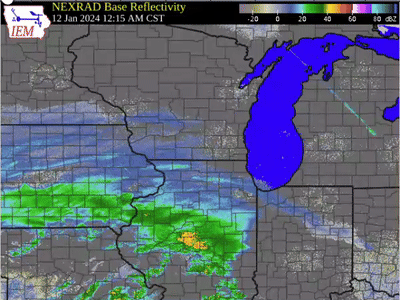 Radar Loop of the Storm |
Snow Totals
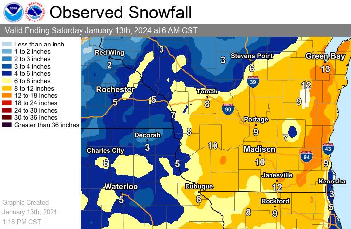
Location                     Amount    Time/Date       Lat/Lon

...Iowa...

...Allamakee County...
Postville 5.5 NE             5.3 in    0700 AM 01/13   43.14N/91.49W
Monona 9.8 N                 2.0 in    0700 AM 01/13   43.19N/91.35W

...Chickasaw County...
New Hampton 0.4 SW           7.6 in    0700 AM 01/13   43.06N/92.32W
Fredericksburg 0.3 S         7.3 in    0800 AM 01/13   42.96N/92.20W
New Hampton                  6.5 in    0700 AM 01/13   43.06N/92.32W

...Clayton County...
Monona 0.2 WNW               8.9 in    0630 AM 01/13   43.05N/91.39W
Guttenberg Dam 10            6.0 in    0800 AM 01/13   42.79N/91.10W
Elkader 6.8 WSW              4.8 in    0630 AM 01/13   42.81N/91.52W

...Fayette County...
3 NNW Fayette                6.0 in    1154 AM 01/12   42.88N/91.83W

...Winneshiek County...
1 E Decorah                  6.0 in    0946 AM 01/13   43.31N/91.77W
7 ENE Decorah                3.8 in    0902 AM 01/13   43.34N/91.64W

...Minnesota...

...Dodge County...
1 NW Kasson                  7.0 in    0836 AM 01/13   44.04N/92.77W
Mantorville 1.9 ESE          5.0 in    0700 AM 01/13   44.05N/92.72W
1 ENE Kasson                 5.0 in    0745 AM 01/13   44.04N/92.74W
Hayfield 0.3 SSE             2.5 in    0730 AM 01/13   43.89N/92.85W
West Concord                 2.0 in    1230 PM 01/12   44.16N/92.90W

...Fillmore County...
Mabel                        4.0 in    0800 AM 01/13   43.52N/91.76W
Wykoff 3.1 NW                3.2 in    0700 AM 01/13   43.74N/92.31W
Chatfield 9.0 ESE            3.2 in    0700 AM 01/13   43.79N/92.03W

...Houston County...
3 ENE Houston                6.8 in    1051 PM 01/12   43.77N/91.51W
Hokah 4 NW                   5.1 in    0700 AM 01/13   43.80N/91.43W
1 ENE Mound Prairie          5.0 in    0700 AM 01/13   43.79N/91.42W
Caledonia                    4.2 in    0700 AM 01/13   43.63N/91.50W
3 ENE Mound Prairie          3.0 in    0415 PM 01/12   43.80N/91.41W
2 ENE Mound Prairie          3.0 in    0431 PM 01/12   43.80N/91.41W

...Mower County...
3 ENE Mapleview              4.7 in    0905 AM 01/13   43.71N/92.93W
Waltham 2.0 SE               4.3 in    0800 AM 01/13   43.80N/92.85W
Austin 2.4 W                 3.6 in    0700 AM 01/13   43.67N/93.02W

...Olmsted County...
2 NE Rochester               6.5 in    0500 AM 01/13   44.04N/92.44W
Elgin 2SSW                   6.1 in    0700 AM 01/13   44.10N/92.27W
Chatfield 2.7 NNW            6.1 in    0800 AM 01/13   43.88N/92.22W
Stewartville 4.3 E           6.0 in    0600 AM 01/13   43.86N/92.40W
Stewartville                 4.5 in    0919 AM 01/13   43.86N/92.49W
2 NNE Rochester              4.3 in    0924 AM 01/13   44.04N/92.46W
3 NW Rochester               4.0 in    0856 AM 01/13   44.04N/92.52W
Rochester 5.7 N              3.4 in    0800 AM 01/13   44.10N/92.46W
Rochester 1.5 WSW            3.0 in    0600 AM 01/13   44.00N/92.50W
Rochester 4.7 N              2.6 in    0700 AM 01/13   44.08N/92.48W

...Wabasha County...
Kellogg 0.1 N                7.0 in    0700 AM 01/13   44.31N/92.00W
3 NW Wabasha                 6.0 in    1000 PM 01/12   44.40N/92.10W
Lake City                    5.5 in    0925 AM 01/13   44.45N/92.27W
Theilman 1 SSW               5.3 in    0730 AM 01/13   44.28N/92.19W
Lake City 0.7 SE             4.8 in    0800 AM 01/13   44.43N/92.27W
Zumbro Falls 3.5 SSW         1.6 in    0740 AM 01/13   44.24N/92.46W

...Winona County...
Winona                       7.0 in    0924 AM 01/13   44.05N/91.66W
Winona 2.0 ESE               6.2 in    0730 AM 01/13   44.04N/91.63W
La Crescent 4.0 NNW          5.2 in    0700 AM 01/13   43.88N/91.34W
Winona 1.9 ESE               4.8 in    0724 AM 01/13   44.04N/91.63W

...Wisconsin...

...Adams County...
Grand Marsh                  13.0 in   0846 AM 01/13   43.89N/89.71W
8 ENE Friendship             12.0 in   0747 AM 01/13   44.01N/89.66W
6 NNE Grand Marsh            12.0 in   0950 AM 01/13   43.97N/89.68W
Oxford 4.0 W                 11.8 in   0700 AM 01/13   43.79N/89.64W
0.6 W Friendship             10.5 in   0700 AM 01/13   43.98N/89.83W
Dellwood                     8.0 in    0937 PM 01/12   43.98N/89.94W
9 ENE Friendship             7.6 in    0355 PM 01/12   44.01N/89.66W

...Buffalo County...
Mondovi                      6.0 in    0953 AM 01/13   44.57N/91.67W
Mondovi 12.1 SSE             5.2 in    0705 AM 01/13   44.40N/91.60W

...Clark County...
Neillsville                  5.5 in    0801 AM 01/13   44.56N/90.59W

...Crawford County...
2 N Prairie Du Chien         14.4 in   0851 AM 01/13   43.07N/91.14W
Gays Mills 1.0 NE            11.8 in   0800 AM 01/13   43.33N/90.84W
1 S De Soto                  9.5 in    0757 AM 01/13   43.41N/91.19W
4 NNE Boscobel               9.0 in    1059 AM 01/13   43.20N/90.68W
Bell Center                  8.0 in    1230 PM 01/12   43.30N/90.83W
Seneca                       8.0 in    1235 PM 01/12   43.27N/90.96W
Ferryville                   8.0 in    0746 AM 01/13   43.34N/91.08W

...Grant County...
Platteville                  15.0 in   0851 AM 01/13   42.74N/90.48W
Stitzer                      14.0 in   0856 AM 01/13   42.93N/90.62W
Lancaster                    12.5 in   0741 AM 01/13   42.85N/90.71W
3 NE Mount Hope              11.0 in   0954 AM 01/13   43.00N/90.82W
2 SE Blue River              10.0 in   0953 PM 01/12   43.17N/90.55W
Cassville 7.8 ENE            5.9 in    0700 AM 01/13   42.75N/90.84W

...Jackson County...
Melrose 3.6 W                7.6 in    0700 AM 01/13   44.13N/91.07W
Black River Falls            5.2 in    0830 AM 01/13   44.29N/90.85W

...Juneau County...
New Lisbon                   13.0 in   1007 AM 01/13   43.88N/90.16W
1.0 E Mauston                11.0 in   0800 AM 01/13   43.79N/90.06W

...La Crosse County...
Rockland                     12.0 in   0952 AM 01/13   43.91N/90.92W
Newburg Corners              10.0 in   0955 AM 01/13   43.78N/90.98W
Onalaska 1.9 E               8.0 in    0700 AM 01/13   43.89N/91.18W
French Island                7.6 in    0600 AM 01/13   43.86N/91.27W
1 WSW West Salem             7.6 in    1124 AM 01/13   43.90N/91.10W
2 E La Crosse                7.0 in    0600 AM 01/13   43.82N/91.19W
La Crosse 4NNW               6.7 in    0730 AM 01/13   43.87N/91.27W
2 E Onalaska                 6.6 in    0915 PM 01/12   43.89N/91.18W
Coon Valley 4.5 NNW          6.5 in    0700 AM 01/13   43.76N/91.06W
1 ESE La Crosse              6.5 in    0738 AM 01/13   43.82N/91.21W
3 SSE La Crosse              6.5 in    0951 AM 01/13   43.78N/91.21W
1 SSW Onalaska               6.0 in    1026 AM 01/13   43.88N/91.23W
Holmen 2 S                   5.8 in    0700 AM 01/13   43.93N/91.25W
Holmen 1.7 SSE               5.8 in    0700 AM 01/13   43.93N/91.24W
2 SSE Holmen                 2.3 in    1200 PM 01/12   43.93N/91.24W
4 NE New Amsterdam           2.0 in    0135 PM 01/12   44.03N/91.27W

...Monroe County...
1 NNW Tomah                  11.0 in   0941 AM 01/13   44.01N/90.51W
Wyeville                     8.8 in    0751 AM 01/13   44.03N/90.39W
Warrens                      8.2 in    1032 AM 01/13   44.13N/90.50W
Cataract                     6.5 in    0743 AM 01/13   44.09N/90.84W
0.5 SW Sparta                5.0 in    0800 AM 01/13   43.94N/90.82W

...Richland County...
2 ENE Richland Center        13.8 in   0827 AM 01/13   43.35N/90.34W
Richland Center 4 N          9.5 in    0700 AM 01/13   43.40N/90.39W
Richland Center 4.0 N        9.5 in    0800 AM 01/13   43.40N/90.39W

...Taylor County...
Medford 0.8 ENE              1.9 in    0700 AM 01/13   45.14N/90.33W

...Trempealeau County...
Ettrick 4.0 WNW              5.7 in    0715 AM 01/13   44.19N/91.34W
4 NW Stevenstown             3.3 in    0939 AM 01/13   44.07N/91.23W

...Vernon County...
Readstown                    12.8 in   0825 AM 01/13   43.45N/90.76W
La Farge                     12.5 in   0700 AM 01/13   43.57N/90.63W
Westby                       12.0 in   1125 AM 01/13   43.65N/90.86W
Viola                        11.3 in   0737 AM 01/13   43.51N/90.67W
Hillsboro 2 SW               10.0 in   0700 AM 01/13   43.63N/90.38W
0.5 E Viroqua                9.5 in    0700 AM 01/13   43.56N/90.88W
Ontario                      9.4 in    1203 AM 01/13   43.72N/90.59W
1 NNW Valley                 9.0 in    0600 PM 01/12   43.66N/90.55W
Viroqua                      8.0 in    0826 AM 01/13   43.56N/90.89W
4 ESE Genoa                  7.0 in    1006 AM 01/13   43.55N/91.14W
Stoddard 1.5 NE              4.8 in    0730 AM 01/13   43.67N/91.19W
Viroqua 0.8 ESE              4.1 in    0700 AM 01/13   43.55N/90.87W

Observations are collected from a variety of sources with varying
equipment and exposures. We thank all volunteer weather observers
for their dedication. Not all data listed are considered official.

$$
Wind:
...HIGHEST WIND REPORTS...

Location                     Speed     Time/Date       Lat/Lon

...Iowa...

...Chickasaw County...
New Hampton                  37 MPH    0350 AM 01/13   43.07N/92.46W

...Clayton County...
Monona                       22 MPH    1004 PM 01/13   43.04N/91.39W

...Fayette County...
Oelwein Municipal Airport    41 MPH    0755 PM 01/12   42.68N/91.97W
Hawkeye                      37 MPH    0205 AM 01/13   42.96N/91.95W

...Floyd County...
Charles City Airport         45 MPH    0455 PM 01/12   43.07N/92.62W
Greene                       43 MPH    0425 PM 01/12   42.93N/92.81W
2 NE Dougherty               30 MPH    0250 AM 01/13   42.95N/93.01W
Nora Springs                 26 MPH    1255 PM 01/12   43.20N/93.02W
Charles City                 25 MPH    0615 PM 01/12   43.05N/92.67W
Rudd                         22 MPH    0825 PM 01/13   43.18N/92.83W

...Howard County...
Saratoga                     43 MPH    0550 PM 01/12   43.37N/92.47W
Riceville                    32 MPH    1130 PM 01/13   43.36N/92.48W

...Mitchell County...
Osage                        29 MPH    0755 PM 01/13   43.26N/92.89W
Saint Ansgar                 26 MPH    0205 AM 01/13   43.39N/92.98W
Stacyville                   24 MPH    0219 PM 01/12   43.44N/92.78W

...Winneshiek County...
Decorah                      36 MPH    0440 AM 01/13   43.25N/91.70W
Decorah Municipal Airport    32 MPH    0755 PM 01/12   43.27N/91.72W
Calmar                       23 MPH    0430 PM 01/12   43.25N/91.82W
1 ENE Jackson Junction       20 MPH    0900 PM 01/13   43.11N/92.04W

...Minnesota...

...Dodge County...
U.s.14 - Byron - Mp 200      36 MPH    0700 PM 01/12   44.02N/92.71W
Dodge Center Airport         33 MPH    0815 PM 01/12   44.02N/92.82W
Hayfield                     29 MPH    0417 PM 01/13   43.89N/92.85W
Claremont                    21 MPH    1125 PM 01/13   44.07N/93.01W

...Fillmore County...
U.s.63 - Le Roy - Mp 0.5     45 MPH    0545 PM 01/12   43.51N/92.37W
T.h.52 - Canton - Mp 2       38 MPH    0535 PM 01/12   43.52N/91.89W
Preston Airport              37 MPH    0415 AM 01/13   43.68N/92.17W
Lanesboro                    22 MPH    1115 PM 01/12   43.65N/91.84W

...Houston County...
Hokah                        29 MPH    0720 PM 01/12   43.80N/91.43W
T.h.44 - Hokah - Mp 60       28 MPH    0640 AM 01/13   43.72N/91.44W

...Mower County...
I-90 - Dexter - Mp 195       40 MPH    0615 PM 01/12   43.73N/92.68W
U.s.218 - Lyle - Mp 4        40 MPH    0830 PM 01/13   43.56N/92.95W
Austin                       36 MPH    0915 AM 01/13   43.56N/93.02W
Austin Municipal Airport     36 MPH    0615 PM 01/13   43.67N/92.92W
Lyle                         33 MPH    1100 PM 01/12   43.51N/92.94W
Austin                       24 MPH    0615 AM 01/12   43.56N/92.99W

...Olmsted County...
Rochester International Airp 39 MPH    0339 PM 01/12   43.90N/92.50W
I-90 - Eyota - Mp 226        36 MPH    1120 PM 01/12   43.96N/92.21W
U.s.63 - Stewartville - Mp 3 35 MPH    0600 AM 01/13   43.90N/92.48W
Mayo Helipad                 33 MPH    1115 AM 01/13   44.02N/92.48W
Byron                        30 MPH    0345 PM 01/13   44.04N/92.64W
Rochester                    26 MPH    0235 AM 01/13   44.09N/92.51W

...Wabasha County...
U.s.63 - Lake City - Mp 62.9 38 MPH    0245 AM 01/13   44.38N/92.37W
Lake City                    34 MPH    0430 AM 01/13   44.32N/92.44W
U.s.61 - Kellogg - Mp 53     34 MPH    0145 AM 01/13   44.28N/91.99W
Lake City                    24 MPH    0515 AM 01/13   44.44N/92.28W

...Winona County...
I-90 - La Crescent - Mp 276. 40 MPH    0820 PM 01/12   43.86N/91.30W
I-90 - Ridgeway - Mp 261     35 MPH    0150 AM 01/13   43.91N/91.54W
Winona Municipal Airport     32 MPH    0235 AM 01/13   44.07N/91.70W
U.s.61 - Winona              26 MPH    0800 AM 01/13   43.98N/91.43W

...Wisconsin...

...Clark County...
Greenwood                    25 MPH    1220 PM 01/13   44.72N/90.60W

...Crawford County...
Steuben                      31 MPH    0245 AM 01/13   43.21N/91.00W
Prairie Du Chien  Airport    30 MPH    0115 AM 01/14   43.02N/91.12W
Crawford Co. Sth 27 Sb 0.25  25 MPH    0950 PM 01/12   43.31N/90.94W
De Soto                      17 MPH    0836 PM 01/13   43.42N/91.19W

...Grant County...
Lancaster                    34 MPH    0841 PM 01/12   42.83N/90.69W
Platteville                  33 MPH    0845 PM 01/12   42.74N/90.46W
Platteville Municipal Airpor 33 MPH    1235 PM 01/12   42.68N/90.43W
Boscobel Airport             31 MPH    0924 PM 01/12   43.15N/90.68W
Boscobel                     28 MPH    0503 PM 01/12   43.15N/90.68W
Grant Co. Us 151 Nb At Sth 1 21 MPH    0259 AM 01/14   42.52N/90.62W

...Jackson County...
1 E Black River Falls        26 MPH    0115 AM 01/13   44.30N/90.73W
Black River Falls            26 MPH    1225 PM 01/13   44.19N/90.74W
Black River Falls Area Airpo 24 MPH    0935 PM 01/13   44.25N/90.85W
I-94 Eb 0.7 Mi Southeast Of  22 MPH    0929 AM 01/13   44.34N/90.91W

...Juneau County...
Mauston Airport              28 MPH    0735 AM 01/13   43.83N/90.13W
Volk Field                   28 MPH    0328 AM 01/13   43.93N/90.27W
Necedah                      25 MPH    0348 AM 01/14   44.03N/90.08W
New Lisbon                   21 MPH    0501 PM 01/12   43.87N/90.17W
Uscrn Site Near Necedah 5wnw 21 MPH    0600 AM 01/13   44.06N/90.17W

...La Crosse County...
La Crosse Regional Airport   36 MPH    0554 AM 01/13   43.88N/91.25W
I-90 Eb At Ush 53 Nb         35 MPH    0600 AM 01/13   43.86N/91.24W
Onalaska                     32 MPH    0336 PM 01/13   43.89N/91.18W
La Crosse                    29 MPH    0600 PM 01/12   43.77N/91.22W
Burns                        21 MPH    0619 AM 01/13   43.91N/90.97W
Holmen                       20 MPH    0545 PM 01/12   43.96N/91.23W

...Monroe County...
Sparta/Fort McCoy Airport    23 MPH    0955 AM 01/13   43.97N/90.73W
Tomah                        19 MPH    1105 AM 01/12   43.99N/90.67W
Millston                     19 MPH    0625 AM 01/13   44.15N/90.69W

...Taylor County...
Medford Airport              30 MPH    0535 AM 01/13   45.10N/90.30W
Medford                      28 MPH    0515 AM 01/13   45.30N/90.30W
3 NE Lublin                  24 MPH    1014 PM 01/12   45.11N/90.69W
STETSONVILLE                 24 MPH    0909 PM 01/12   45.04N/90.34W
Westboro                     23 MPH    0305 AM 01/13   45.37N/90.31W

...Trempealeau County...
Trempealeau                  22 MPH    0855 AM 01/13   44.07N/91.51W

...Vernon County...
Viroqua Municipal Airport    31 MPH    0655 AM 01/13   43.58N/90.90W
Genoa                        20 MPH    1134 AM 01/13   43.56N/91.22W

Observations are collected from a variety of sources with varying
equipment and exposures. We thank all volunteer weather observers
for their dedication. Not all data listed are considered official.

$$
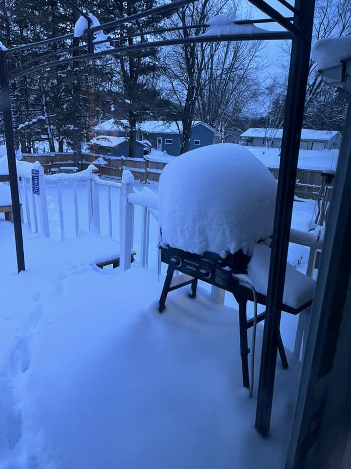
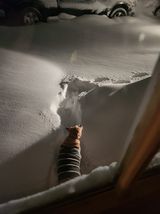
Photos:
 |
 |
 |
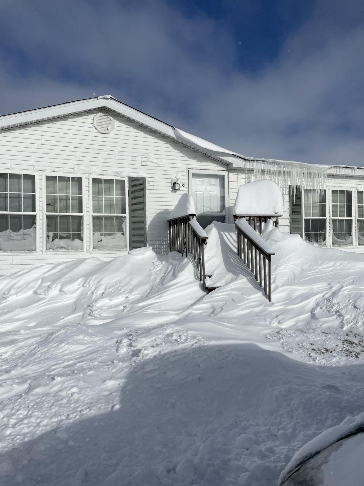 |
| Crawford County, WI (Hunter Heisz) |
Ontario, WI (Daniel Yszenga) |
Prairie du Chien, WI (Tori King) |
Westby, WI (David K.) |
Radar:
 |
| Local Radar Loop |
Additional Information
The Forecast
 |
 |
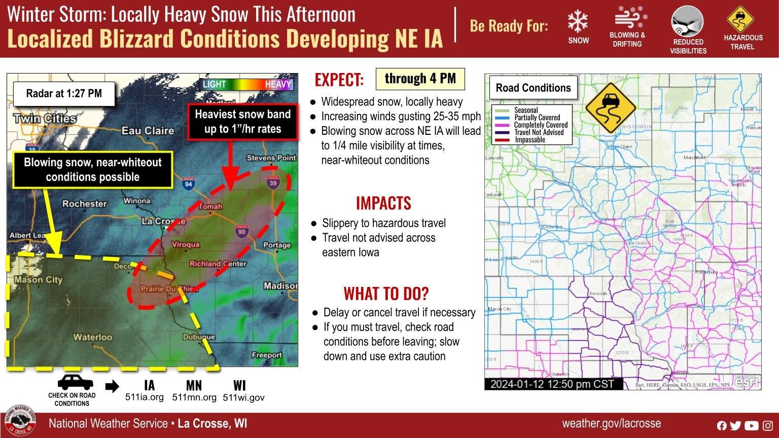 |
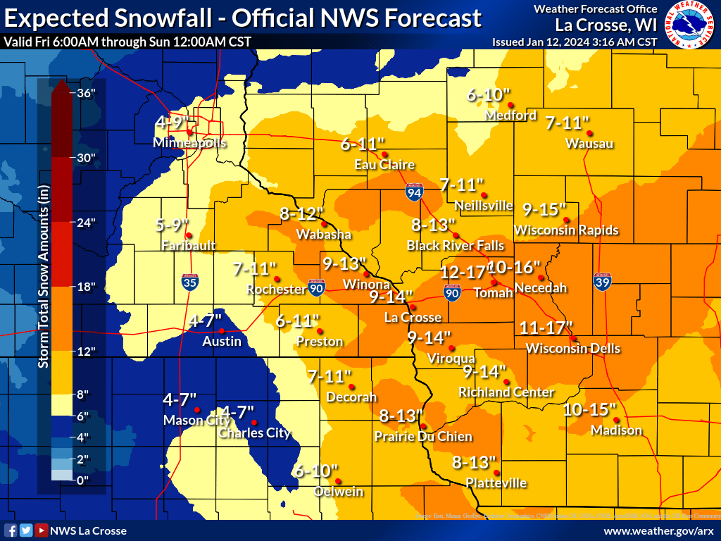
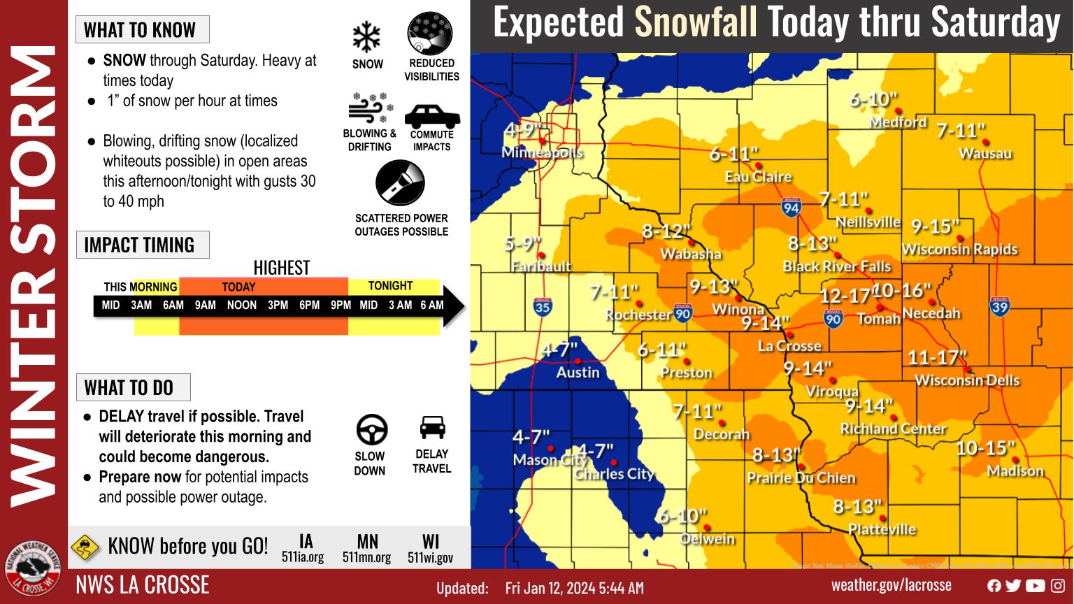
| Expected Snowfall Forecast | Graphic issued Jan 12, 2024 | Graphical Update Issued Jan 12, 2024 |
 |
Media use of NWS Web News Stories is encouraged! Please acknowledge the NWS as the source of any news information accessed from this site. |
|


 Weather Story
 Weather Map
 Local Radar