Overview
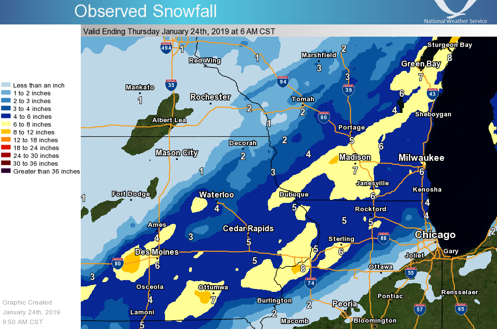
| A complex weather system brought multiple bouts of accumulating snow to the region from early Tuesday morning (Jan 22) through mid-day Wednesday. The storm focused the highest accumulating snow across southern Wisconsin, eastern Iowa, and northern Illinois. A few hours of freezing drizzle occurred early in the storm on Tuesday morning, providing a light glaze of ice. This system was challenging to forecast as it had various pieces, and their interaction ultimately determined the snow totals across the area. A southward shift to the snow totals became apparent early Tuesday morning. |
 |
| Snowfall Totals |
Snow/Ice
...SNOWFALL REPORTS FROM JAN 22-23 2019...

Location                     Amount

...Iowa...

...Allamakee County...
5 NE Postville               2.6 in
Waukon 4SW                   1.0 in

...Chickasaw County...
Ionia 2W                     1.0 in
New Hampton                  1.0 in

...Clayton County...
Guttenberg Dam 10            5.0 in
Strawberry Point             4.2 in
Elkader 6SSW                 3.8 in
Volga 1NE                    3.5 in

...Fayette County...
Fayette                      2.0 in

...Floyd County...
Charles City                 0.5 in

...Howard County...
Cresco 1NE                   1.4 in
Elma                         0.5 in

...Mitchell County...
St Ansgar                    0.2 in
Osage                         T in

...Winneshiek County...
Decorah                      2.5 in
7 ENE Decorah                1.6 in

...Minnesota...

...Dodge County...
Hayfield                     0.2 in

...Fillmore County...
Mabel                        1.8 in
1 SSE Pilot Mound            0.7 in
Spring Valley 3E             0.4 in
Lanesboro 2NE                0.3 in
1 W Fillmore                 0.3 in
Preston                       T in

...Houston County...
Caledonia                    1.0 in
4 NW Eitzen                  0.5 in

...Mower County...
Grand Meadow                 1.0 in

...Olmsted County...
Rochester International Airp 0.6 in
2 NE Rochester               0.5 in
Elgin 2SSW                   0.1 in

...Wabasha County...
Theilman 1SSW                0.3 in
Wabasha                      0.2 in

...Winona County...
Winona Dam 5A                3.0 in
Minnesota City Dam 5         1.1 in
1 WSW Winona                 0.9 in
La Crescent Dam 7            0.5 in

...Wisconsin...

...Adams County...
Friendship                   3.8 in

...Buffalo County...
Alma Dam 4                   0.5 in

...Crawford County...
3 NE Mount Zion              4.0 in
Prairie Du Chien             3.7 in
Gays Mills                   3.5 in
Lynxville Dam 9              3.0 in
Steuben 4SE                  2.4 in
1 WNW Mount Zion             2.0 in
De Soto 1 SE                 2.0 in

...Grant County...
Potosi                      10.5 in
2 WSW Burton                 9.0 in
Lancaster                    7.0 in
Lancaster 4wsw               6.9 in
1 W Platteville              5.0 in
5 E Mount Hope               5.0 in
Cuba City                    4.8 in

...Jackson County...
Hatfield Dam                 2.0 in

...Juneau County...
1 NW Wisconsin Dells         7.0 in
Mauston 1se                  4.5 in
Union Center                 3.3 in

...La Crosse County...
West Salem                   2.1 in
La Crosse Weather Office     1.6 in
Holmen 2S                    1.5 in
La Crosse 4NNW               1.5 in
La Crosse Regional Airport   1.5 in
5 SSE La Crosse              1.2 in

...Monroe County...
Warrens 4WSW                 3.4 in
Cashton 3NNW                 1.6 in
Sparta                       0.8 in

...Taylor County...
Medford                      1.3 in

...Trempealeau County...
Ettrick 4WNW                 1.4 in
Trempealeau Dam 6            1.2 in
Osseo                        1.1 in

...Vernon County...
La Farge                     4.7 in
Hillsboro 2SW                3.6 in
3 WNW Viola                  3.6 in
Viroqua                      2.9 in
Hillsboro WSW                2.0 in
Viroqua 0.8 ESE              1.8 in
Stoddard                     1.6 in
Stoddard 5NNE                1.3 in
Genoa Dam 8                  1.0 in
Westby 3ENE                  0.5 in
$$
Radar:
 |
|||
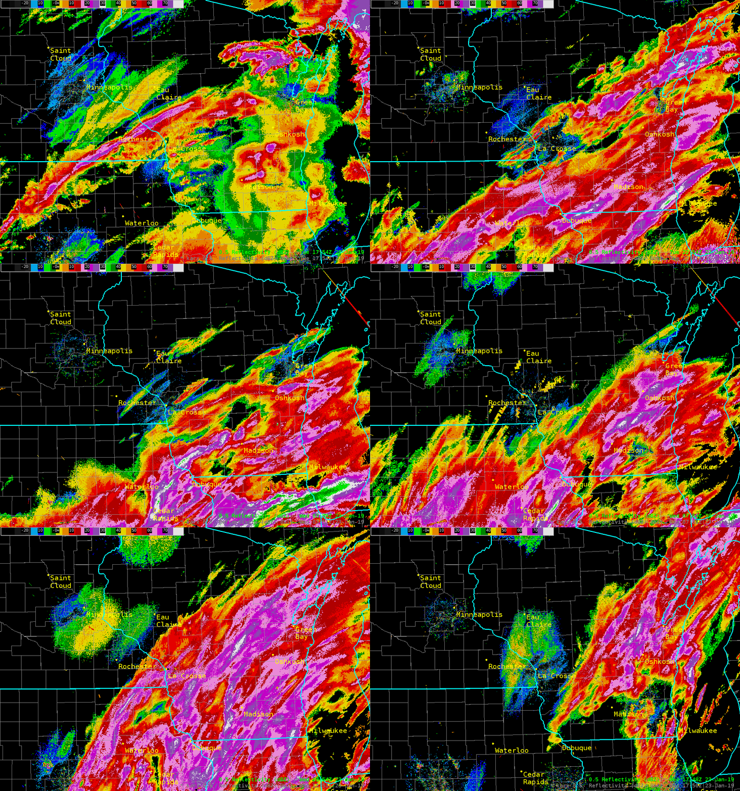
| Radar loop from noon Monday January 22 through noon Tuesday January 23 2019 |
 |
Media use of NWS Web News Stories is encouraged! Please acknowledge the NWS as the source of any news information accessed from this site. |
 |