Overview
|
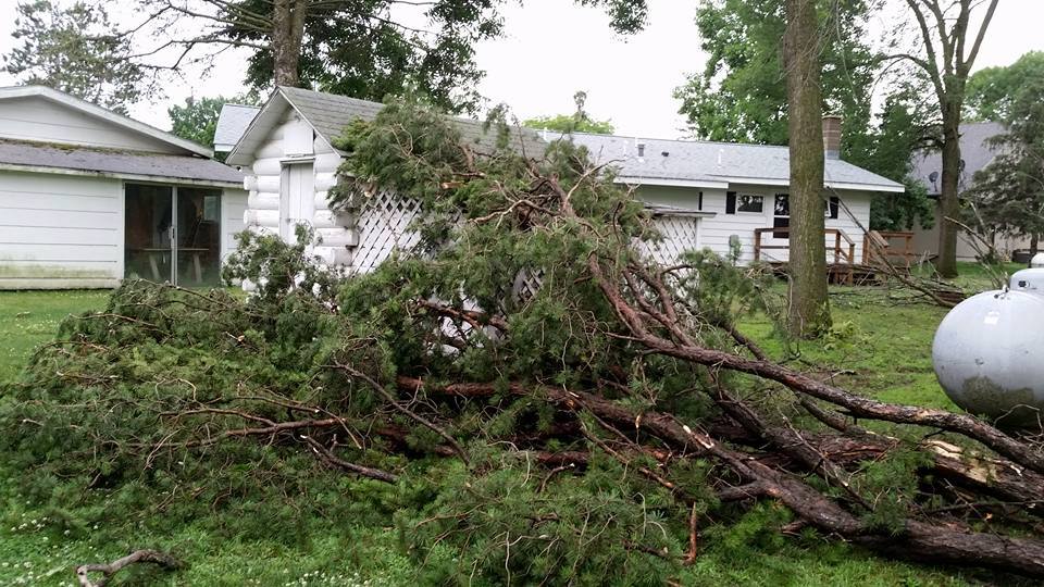
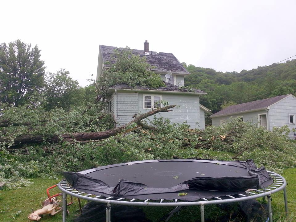
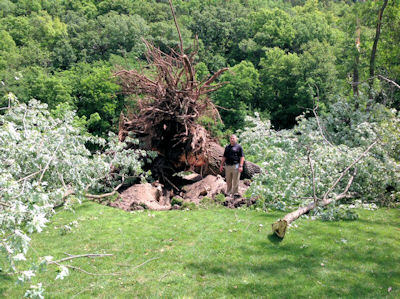
A line of strong to severe thunderstorms moved across the area on the evening of July 5th, 2016, producing a swath of damaging winds from 45 to 95 mph, along with embedded small tornadoes. Numerous trees were downed, and there were sporadic power outages and damage to some buildings. There was quite a bit of wind damage along the track of the storm - some extreme. There were four (4) documented tornadoes as well - 3 were EF1s and 1 EF0. |
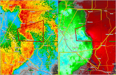
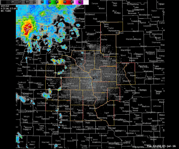 Radar Loop from the evening of July 5, 2016. (Warnings: severe thunderstorm-yellow, tornado-red) |
Tornado Information
|
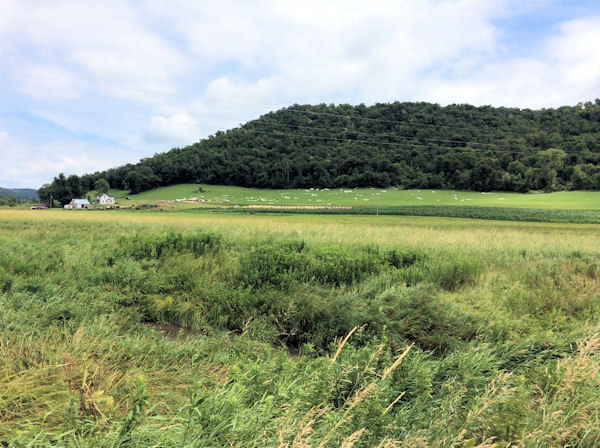
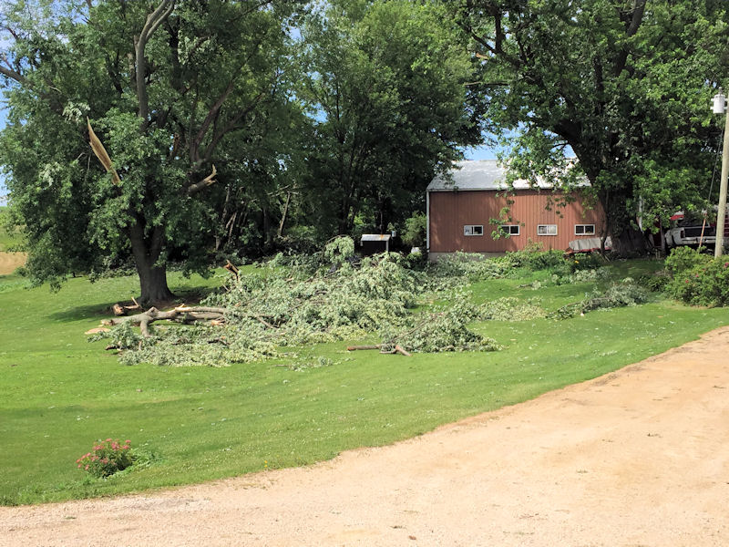
Tornado #1 - 5 miles SW of Lake City, MN
Track Map 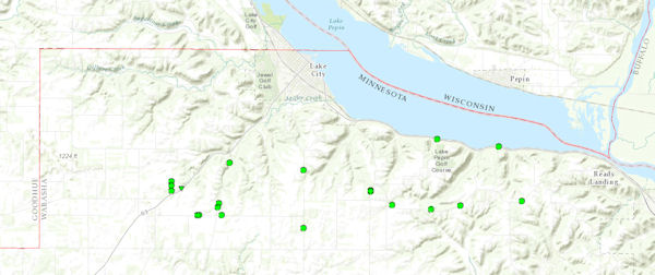  |
||||||||||||||||
 |
 |
 |
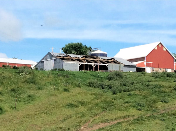 |
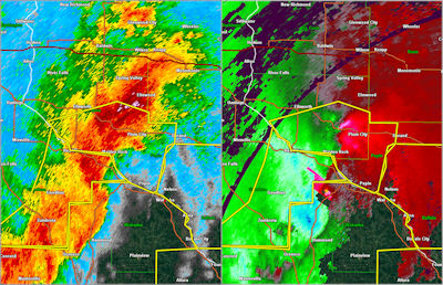
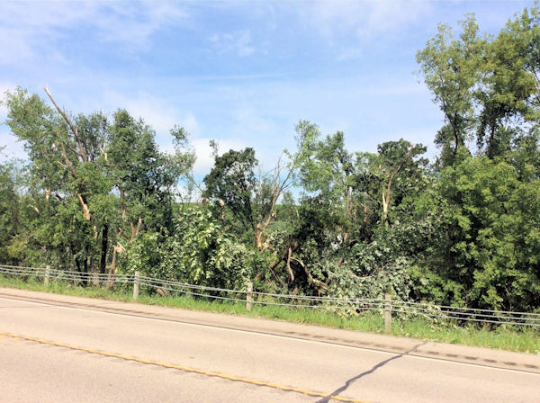
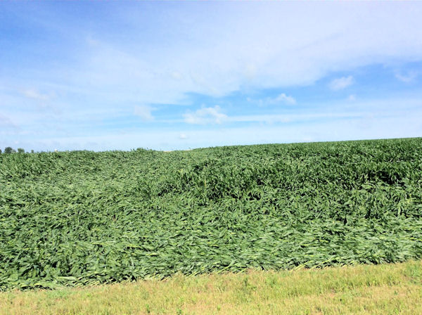
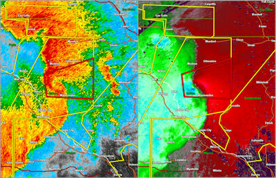
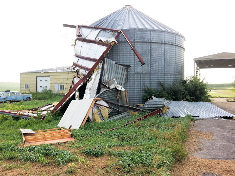
| Radar image during time of tornado | Tornado damage to trees | Wind damage to crops | Farm building damaged by wind gusts |
|
Tornado #2 - 2 miles NNW of Cream, WI
Track Map 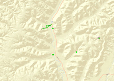 |
||||||||||||||||
 |
 |
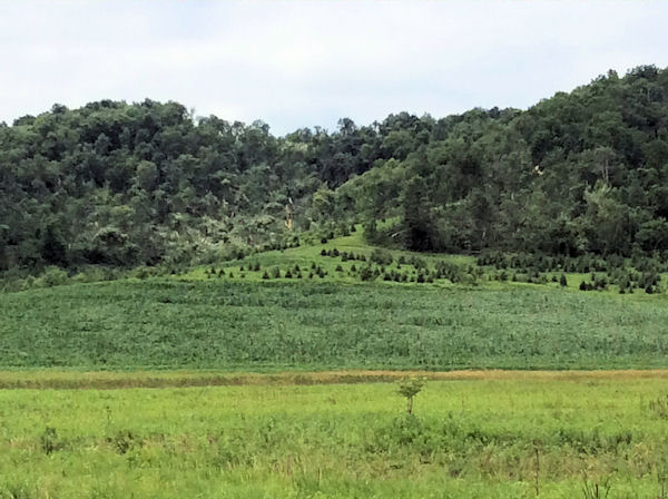 |
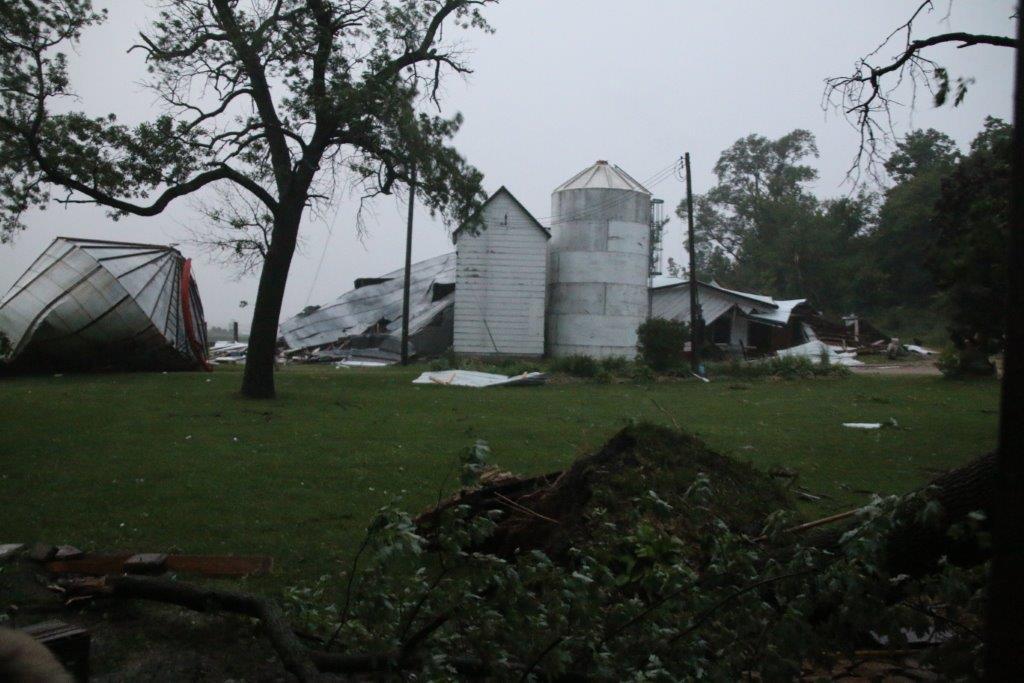
| Radar image during time of tornado | Destroyed farm building | Tree damage |
|
Tornado #3 - 2 miles NNW of Waumandee, WI
Track Map 
|
||||||||||||||||
 |
 |
| Radar image during time of tornado | Destroyed hunting building |
|
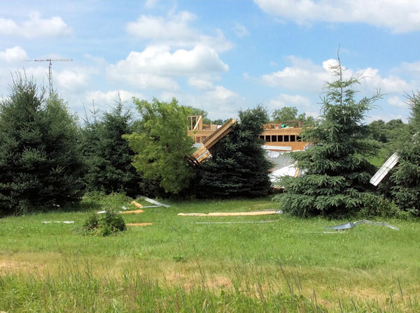
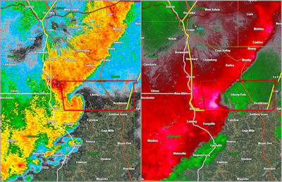
Tornado #4 - Near Retreat, WI
Track Map 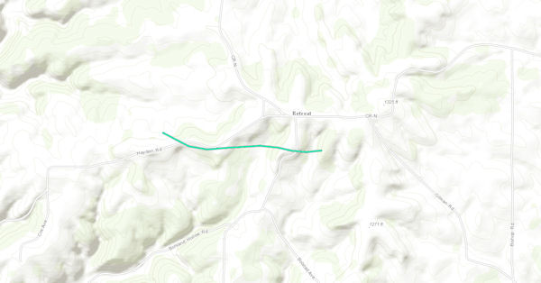
|
||||||||||||||||
 |
 |
| Radar image during time of tornado | Tree damage near Retreat, WI |
The Enhanced Fujita (EF) Scale classifies tornadoes into the following categories:
| EF0 Weak 65-85 mph |
EF1 Moderate 86-110 mph |
EF2 Significant 111-135 mph |
EF3 Severe 136-165 mph |
EF4 Extreme 166-200 mph |
EF5 Catastrophic 200+ mph |
 |
|||||
Wind Reports
Public Information Statement
National Weather Service La Crosse WI
1208 AM CDT Wed Jul 6 2016

...Wind Reports...

Location                     Speed     Time/Date       Lat/Lon

...Iowa...

...Fayette County...
Oelwein Municipal Airport    40 MPH    1115 PM 07/05   42.68N/91.97W
Fayette-CWOP                 27 MPH    1102 PM 07/05   42.84N/91.80W

...Floyd County...
Charles City Airport         39 MPH    1015 PM 07/05   43.07N/92.61W
Rockford                     28 MPH    0954 PM 07/05   43.05N/92.93W

...Howard County...
3 NE Riceville               27 MPH    0933 PM 07/05   43.40N/92.50W

...Winneshiek County...
5 NW Frankville              47 MPH    1020 PM 07/05   43.25N/91.70W

...Minnesota...

...Dodge County...
NE Kasson                    67 MPH    0838 PM 07/05
2 E Kasson                   46 MPH    0845 PM 07/05   44.02N/92.71W
Dodge Center Airport         44 MPH    0854 PM 07/05   44.02N/92.83W
Hayfield                     32 MPH    0947 PM 07/05   43.89N/92.85W

...Fillmore County...
Preston Airport              56 MPH    0920 PM 07/05   43.68N/92.18W
2 ESE Canton                 38 MPH    0945 PM 07/05   43.51N/91.88W

...Mower County...
1 ENE Dexter                 54 MPH    0850 PM 07/05   43.73N/92.68W
Austin Municipal Airport     47 MPH    0856 PM 07/05   43.66N/92.93W

...Olmsted County...
Rochester International Airp 56 MPH    0859 PM 07/05   43.91N/92.50W
Mayo Helipad                 48 MPH    0855 PM 07/05   44.02N/92.48W
3 N Stewartville             43 MPH    0850 PM 07/05   43.90N/92.48W
1 SSE Stewartville           38 MPH    0842 PM 07/05   43.84N/92.48W
Byron                        34 MPH    0830 PM 07/05   44.04N/92.64W
2 NE Rochester               27 MPH    0905 PM 07/05   44.04N/92.44W

...Wabasha County...
2 NNW Zumbro Falls           69 MPH    0949 PM 07/05   44.32N/92.44W
1 SSE Kellogg                41 MPH    0850 PM 07/05   44.28N/91.99W
Mazeppa                      40 MPH    0833 PM 07/05   44.27N/92.55W
Lake City                    35 MPH    0851 PM 07/05   44.45N/92.27W

...Winona County...
1 E Ridgeway                 52 MPH    0945 PM 07/05   43.91N/91.54W

...Wisconsin...

...Crawford County...
Prairie Du Chien  Airport    40 MPH    1055 PM 07/05   43.02N/91.12W
1 WNW Prairie Du Chien       37 MPH    1102 PM 07/05   43.05N/91.15W
De Soto                      26 MPH    1021 PM 07/05   43.42N/91.19W

...Grant County...
Boscobel Airport             43 MPH    1106 PM 07/05   43.16N/90.67W
Platteville Municipal Airpor 35 MPH    1155 PM 07/05   42.69N/90.44W

...Jackson County...
Black River Falls Area Airpo 30 MPH    1055 PM 07/05   44.25N/90.86W

...Juneau County...
Volk Field                   44 MPH    1058 PM 07/05   43.94N/90.25W
Mauston Airport              37 MPH    1115 PM 07/05   43.84N/90.14W
Mauston                      29 MPH    1122 PM 07/05   43.80N/90.07W

...La Crosse County...
La Crosse Regional Airport   68 MPH    0958 PM 07/05   43.88N/91.26W
3 W Saint Joseph             38 MPH    1015 PM 07/05   43.78N/91.10W

...Monroe County...
Sparta/Fort McCoy Airport    37 MPH    1035 PM 07/05   43.96N/90.74W
2 E Cataract                 35 MPH    1024 PM 07/05   44.09N/90.79W

...Taylor County...
Medford Airport              32 MPH    1115 PM 07/05   45.10N/90.30W
3 NE Lublin                  31 MPH    1114 PM 07/05   45.11N/90.69W

...Trempealeau County...
2 NNE Tamarack               29 MPH    1107 PM 07/05   44.21N/91.46W

Observations are collected from a variety of sources with varying
equipment and exposures. Not all data listed are considered official.

$$

NWS La Crosse WI
IRIS System
Photos:
More images to be added soon
 |
 |
 |
 |
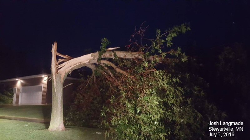
| Tree damage in Stewartville, MN (Photo by Josh Langmade) |
Farm damage near Wilton, WI (Photo by Todd Bloomingdale) |
Farm damage 6 miles north of Byron, MN (Photo by Dwayne Hora) |
Farm damage north of Zumbro Falls, MN |
 |
 |
 |
 |
| Damage near Kendall, WI | Damage near Buffalo City, WI | Damage near Soldiers Grove, WI (Photo by Lisa Christman) |
Damage in Onalaska, WI |
 |
|||
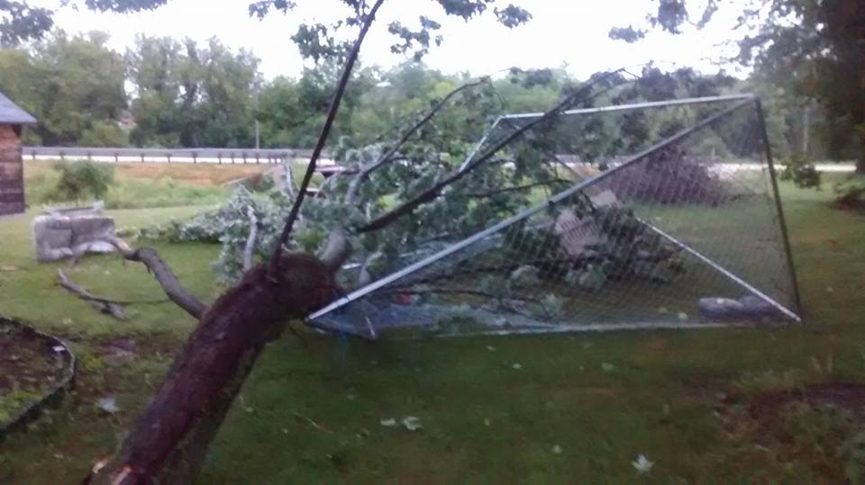
| Damage near Whalan, MN |
Storm Reports
PRELIMINARY LOCAL STORM REPORT...SUMMARY
NATIONAL WEATHER SERVICE LA CROSSE WI
1147 PM CDT TUE JUL 5 2016

..TIME...   ...EVENT...      ...CITY LOCATION...     ...LAT.LON...
..DATE...   ....MAG....      ..COUNTY LOCATION..ST.. ...SOURCE....
            ..REMARKS..

0838 PM     TSTM WND GST     KASSON
07/05/2016  M67 MPH          DODGE              MN   TRAINED SPOTTER

1005 PM     TSTM WND DMG     ONALASKA                43.89N 91.22W
07/05/2016                   LA CROSSE          WI   BROADCAST MEDIA

            NUMEROUS TREES DOWN ALONG OAK FOREST DRIVE.
            TREE ON A HOUSE. SCATTERED POWER OUTAGES.

1005 PM     TSTM WND DMG     2 SE ONALASKA           43.87N 91.20W
07/05/2016                   LA CROSSE          WI   PUBLIC

            FIREWORKS TENT BLOWN DOWN ACROSS FROM MALL.
            PERSON WAS TRAPPED INSIDE AND HAD TO
            RESCUED. NO INJURIES. TIME ESTIMATED BASED
            ON RADAR. .

0958 PM     TSTM WND GST     1 NNE FRENCH ISLAND     43.88N 91.26W
07/05/2016  M68 MPH          LA CROSSE          WI   ASOS

            ASOS STATION LA CROSSE REGIONAL AIRPORT
            /LSE/.

0925 PM     TSTM WND DMG     2 E WHALAN              43.73N 91.89W
07/05/2016                   FILLMORE           MN   TRAINED SPOTTER

            NUMEROUS TREES DOWN ACROSS HWY 108. ROAD
            IMPASSABLE.

0920 PM     TSTM WND GST     2 NW CARIMONA           43.68N 92.18W
07/05/2016  M56 MPH          FILLMORE           MN   AWOS

            AWOS STATION PRESTON AIRPORT /FKA/.

0910 PM     TSTM WND DMG     2 N CREAM               44.35N 91.77W
07/05/2016                   BUFFALO            WI   LAW ENFORCEMENT

            144 X 60 FT MACHINE SHED DESTROYED IN THE
            LAST 10 MIN. TREES DOWN. ALONG HWY 88.

0859 PM     TSTM WND GST     4 N STEWARTVILLE        43.91N 92.50W
07/05/2016  M56 MPH          OLMSTED            MN   ASOS

            ASOS STATION ROCHESTER INTERNATIONAL AIRPORT
            /RST/.

0856 PM     TSTM WND GST     2 ESE AUSTIN            43.66N 92.93W
07/05/2016  M47 MPH          MOWER              MN   AWOS

            AWOS STATION AUSTIN MUNICIPAL AIRPORT /AUM/.

0856 PM     TSTM WND GST     1 W KASSON              44.03N 92.77W
07/05/2016  E65 MPH          DODGE              MN   EMERGENCY MNGR

0855 PM     TSTM WND GST     ROCHESTER               44.02N 92.48W
07/05/2016  M48 MPH          OLMSTED            MN   AWOS

            AWOS STATION MAYO HELIPAD /9MN/.

0854 PM     TSTM WND GST     1 SE DODGE CENTER       44.02N 92.83W
07/05/2016  M44 MPH          DODGE              MN   AWOS

            AWOS STATION DODGE CENTER AIRPORT /TOB/.

0850 PM     TSTM WND GST     1 ENE DEXTER            43.73N 92.68W
07/05/2016  M54 MPH          MOWER              MN   MESONET

            MESONET STATION 1 ENE DEXTER /MN010/.

0850 PM     TSTM WND GST     5 NNW GENOA             44.19N 92.64W
07/05/2016  M75 MPH          OLMSTED            MN   FIRE DEPT/RESCUE

            PEAK WIND GUST MEASURED 75 MPH. SEVERAL
            POWER LINES DOWN AND LOTS OF TREES DOWN.

0850 PM     TSTM WND DMG     2 E MAZEPPA             44.27N 92.50W
07/05/2016                   WABASHA            MN   LAW ENFORCEMENT

            TREES DOWN ACROSS HWY 60 BLOCKING LANES EAST
            OF MAZEPPA NEAR CR 7.

0850 PM     TSTM WND GST     6 NNW GENOA             44.19N 92.65W
07/05/2016  E60 MPH          OLMSTED            MN   TRAINED SPOTTER


0842 PM     TORNADO          1 W WABASHA             44.37N 92.07W
07/05/2016                   WABASHA            MN   COUNTY OFFICIAL

            REPORTS OF TORNADO ON THE GROUND FROM
            SPOTTER NEAR CR 10 AND CR 77 JUST WEST OF
            WABASHA IN PEPIN TOWNSHIP.

0838 PM     HIGH SUST WINDS  2 SSE BERNE             44.13N 92.76W
07/05/2016  E55 MPH          DODGE              MN   EMERGENCY MNGR


0838 PM     HIGH SUST WINDS  3 SSE BERNE             44.13N 92.76W
07/05/2016  E55 MPH          DODGE              MN   EMERGENCY MNGR

0833 PM     TSTM WND DMG     1 SE LAKE CITY          44.43N 92.25W
07/05/2016                   WABASHA            MN   NWS EMPLOYEE

            TREES DOWN AND SOME BRANCHES PARTIALLY
            BLOCKING HWY 61.

0830 PM     TSTM WND DMG     6 SW LAKE CITY          44.39N 92.36W
07/05/2016                   WABASHA            MN   NWS EMPLOYEE

            LOTS OF TREE DAMAGE ALONG HWY 63 NEAR 700TH
            ST. TREES ON ROAD.

0825 PM     TSTM WND DMG     8 N ZUMBRO FALLS        44.40N 92.43W
07/05/2016                   WABASHA            MN   NWS EMPLOYEE

            TREE DOWN ON BARN 3 MILES EAST OF
            BELLCHESTER ALONG CR 9 NEAR CR 82.

0825 PM     TSTM WND GST     3 NNW ZUMBRO FALLS      44.32N 92.44W
07/05/2016  M69 MPH          WABASHA            MN   MESONET

            MESONET STATION 2 NNW ZUMBRO FALLS /C7148/.

0823 PM     TSTM WND DMG     6 NNE ZUMBRO FALLS      44.37N 92.38W
07/05/2016                   WABASHA            MN   NWS EMPLOYEE

            HOME DAMAGED AND BARN DOWN.

0820 PM     TSTM WND DMG     2 N MAZEPPA             44.30N 92.54W
07/05/2016                   WABASHA            MN   NWS EMPLOYEE

            DAMAGE TO GRAIN BIN AND OUT BUILDINGS NEAR
            BELLCHESTER.


&&
.
Rain Reports
Public Information Statement
National Weather Service La Crosse WI
1005 AM CDT Wed Jul 6 2016

...Rainfall Reports Over Past 24 Hours...

Location                     Amount    Time/Date       Lat/Lon

...Iowa...

...Allamakee County...
4 ENE Watson                 0.90 in   0845 AM 07/06   43.11N/91.26W
3 S Dorchester               0.90 in   0900 AM 07/06   43.42N/91.51W
3 SE Waterville              0.89 in   0907 AM 07/06   43.17N/91.24W

...Chickasaw County...
New Hampton                  1.32 in   0700 AM 07/06   43.06N/92.32W
Ionia 2W                     1.21 in   0845 AM 07/06   43.03N/92.50W

...Clayton County...
Volga 1NE                    1.45 in   0600 AM 07/06   42.81N/91.52W
Edgewood                     1.11 in   0530 AM 07/06   42.65N/91.40W
Guttenberg Dam 10            1.10 in   0600 AM 07/06   42.78N/91.10W
Elkader Turkey River         0.95 in   0845 AM 07/06   42.84N/91.40W
Littleport                   0.86 in   0845 AM 07/06   42.75N/91.37W
Monona WWTP                  0.81 in   0700 AM 07/06   43.04N/91.40W
Marquette-Bloody Run Creek   0.30 in   0900 AM 07/06   43.04N/91.21W

...Fayette County...
Waucoma 1WNW                 1.30 in   0700 AM 07/06   43.06N/92.05W
Fayette                      1.08 in   0700 AM 07/06   42.85N/91.82W
Eldorado                     1.07 in   0845 AM 07/06   43.05N/91.81W
1 ENE Alpha                  1.03 in   0700 AM 07/06   43.01N/92.03W

...Floyd County...
Charles City                 0.84 in   0700 AM 07/06   43.06N/92.67W
Charles City Airport         0.82 in   0655 AM 07/06   43.07N/92.61W
Colwell                      0.79 in   0700 AM 07/06   43.16N/92.59W
Nora Springs 2.4 SSE         0.59 in   0700 AM 07/06   43.11N/92.99W
Nashua 2sw                   0.54 in   0700 AM 07/06   42.94N/92.57W

...Howard County...
Elma 6E                      1.42 in   0418 AM 07/06
Elma                         1.37 in   0700 AM 07/06   43.24N/92.44W
Cresco 1NE                   1.32 in   0700 AM 07/06   43.39N/92.09W
3 NE Riceville               0.79 in   0934 AM 07/06   43.40N/92.50W

...Mitchell County...
Osage                        0.93 in   0700 AM 07/06   43.28N/92.81W
St Ansgar                    0.88 in   0630 AM 07/06   43.38N/92.92W

...Winneshiek County...
Bluffton                     1.04 in   0845 AM 07/06   43.41N/91.90W
5 ESE Decorah                0.94 in   0700 AM 07/06   43.26N/91.70W
7 ENE Decorah                0.91 in   0700 AM 07/06   43.34N/91.64W
Fort Atkinson                0.90 in   0700 AM 07/06   43.14N/91.93W

...Minnesota...

...Dodge County...
Claremont 2.5 SSE            0.88 in   0700 AM 07/06   44.01N/92.99W
Dodge Center Airport         0.77 in   0654 AM 07/06   44.02N/92.83W
2 NE Kasson                  0.75 in   0530 AM 07/06   44.05N/92.72W
2 E Claremont                0.64 in   0800 AM 07/06   44.04N/92.95W
Hayfield                     0.36 in   0937 AM 07/06   43.89N/92.85W

...Fillmore County...
Harmony                      1.05 in   0730 AM 07/06   43.55N/92.01W
Mabel                        0.94 in   0635 AM 07/06   43.52N/91.76W
1 W Fillmore                 0.83 in   0700 AM 07/06   43.74N/92.31W
Preston                      0.78 in   0700 AM 07/06   43.66N/92.08W
Preston 6s                   0.77 in   0730 AM 07/06   43.59N/92.11W
3 NE Preston                 0.75 in   0700 AM 07/06   43.71N/92.05W
Preston                      0.68 in   0840 AM 07/06   43.67N/92.07W
Spring Valley                0.67 in   0700 AM 07/06   43.69N/92.39W
Whalan 3.3 SSE               0.65 in   0700 AM 07/06   43.69N/91.90W
Spring Valley 3E             0.59 in   0700 AM 07/06   43.68N/92.33W
Lanesboro-Root River         0.58 in   0930 AM 07/06   43.72N/91.98W
Chatfield                    0.58 in   0700 AM 07/06   43.84N/92.20W
Fillmore                     0.58 in   0930 AM 07/06   43.76N/92.27W
1 SSE Pilot Mound            0.56 in   0700 AM 07/06   43.79N/92.03W
Spring Valley 3sw            0.55 in   0700 AM 07/06   43.66N/92.41W
Lanesboro 2NE                0.51 in   0700 AM 07/06   43.73N/91.94W
Pilot Mound-Root River       0.50 in   0900 AM 07/06   43.78N/92.03W

...Houston County...
Hokah WWTP                   0.95 in   0700 AM 07/06   43.76N/91.35W
4 NW Eitzen                  0.83 in   0800 AM 07/06   43.56N/91.51W
Houston                      0.78 in   0845 AM 07/06   43.77N/91.57W
Houston 7sw                  0.77 in   0730 AM 07/06   43.70N/91.67W
Caledonia                    0.73 in   0700 AM 07/06   43.63N/91.50W
Spring Grove 4n              0.61 in   0700 AM 07/06   43.61N/91.62W
Mound Prairie                0.60 in   0845 AM 07/06   43.78N/91.45W

...Mower County...
Lansing-Cedar River          0.89 in   0930 AM 07/06   43.75N/92.95W
Austin Waste Water Treatment 0.87 in   0800 AM 07/06   43.65N/92.97W
Austin 3 NW - Turtle Creek   0.84 in   0930 AM 07/06   43.65N/92.98W
Austin 3S                    0.82 in   0900 AM 07/06   43.64N/92.97W
Austin Municipal Airport     0.81 in   0655 AM 07/06   43.66N/92.93W
Austin 2NE-Dobbins Creek     0.75 in   0930 AM 07/06   43.67N/92.95W
Ostrander 5.1 WNW            0.57 in   0700 AM 07/06   43.65N/92.52W
Ostrander 5wnw               0.55 in   0730 AM 07/06   43.63N/92.53W
1 ENE Austin                 0.54 in   0800 AM 07/06   43.68N/92.94W

...Olmsted County...
Eyota 2NE                    1.37 in   0930 AM 07/06   44.01N/92.20W
Pine Island 1S               1.04 in   0900 AM 07/06   44.19N/92.65W
2 ENE Rochester              1.04 in   0930 AM 07/06   44.03N/92.43W
1 W Chester                  1.02 in   0630 AM 07/06   44.00N/92.38W
3 N Rochester                1.02 in   0915 AM 07/06   44.06N/92.47W
Byron 4 North                0.90 in   0700 AM 07/06   44.09N/92.64W
Elgin 5SE                    0.90 in   0930 AM 07/06   44.01N/92.11W
Rochester-Cascade Creek      0.90 in   0930 AM 07/06   44.03N/92.47W
Rochester-Beltline           0.89 in   0930 AM 07/06   44.01N/92.47W
Rochester-Beltline Bear Cree 0.88 in   0930 AM 07/06   44.01N/92.45W
4 ESE Douglas                0.87 in   0700 AM 07/06   44.08N/92.48W
2 NE Rochester               0.86 in   0924 AM 07/06   44.04N/92.44W
Elgin 2ssw                   0.85 in   0700 AM 07/06   44.10N/92.27W
Byron                        0.84 in   0938 AM 07/06   44.03N/92.66W
2 N Rock Dell                0.84 in   0630 AM 07/06   43.96N/92.63W
4 NNW Rochester              0.84 in   0700 AM 07/06   44.07N/92.49W
4 ESE Douglas                0.79 in   0935 AM 07/06   44.09N/92.49W
Byron                        0.76 in   0932 AM 07/06   44.04N/92.64W
Oronoco 1W                   0.75 in   0930 AM 07/06   44.17N/92.55W
Oronoco                      0.75 in   0930 AM 07/06   44.16N/92.54W
2 NNW Chester                0.72 in   0600 AM 07/06   44.05N/92.37W
Elba 4.7 SW                  0.70 in   1000 PM 07/05   44.04N/92.09W
Rochester 3W                 0.70 in   0930 AM 07/06   44.02N/92.53W
Rochester International Airp 0.70 in   0654 AM 07/06   43.91N/92.50W
3 ESE Douglas                0.68 in   0935 AM 07/06   44.09N/92.51W
2 W High Forest              0.68 in   0500 AM 07/06   43.85N/92.59W
1 SSE Stewartville           0.60 in   0928 AM 07/06   43.84N/92.48W
Mayo Helipad                 0.54 in   0654 AM 07/06   44.02N/92.48W

...Wabasha County...
Central Point                0.98 in   0700 AM 07/06
Theilman 1SSW                0.90 in   0800 AM 07/06   44.28N/92.19W
Plainview                    0.88 in   0936 AM 07/06   44.17N/92.17W
3 SW Zumbro Falls            0.79 in   0730 AM 07/06   44.24N/92.46W
Lake City                    0.73 in   0933 AM 07/06   44.45N/92.27W
Mazeppa 3ESE                 0.72 in   0930 AM 07/06   44.26N/92.49W
Kellogg-Zumbro River         0.52 in   0900 AM 07/06   44.32N/92.00W
Wabasha                      0.52 in   0700 AM 07/06   44.38N/92.05W
2 NNW Zumbro Falls           0.51 in   0749 AM 07/06   44.32N/92.44W
1 SSE Lake City              0.31 in   0800 AM 07/06   44.43N/92.27W

...Winona County...
Minnesota City Dam 5         1.00 in   0700 AM 07/06   44.16N/91.81W
La Crescent Dam 7            0.84 in   0600 AM 07/06   43.87N/91.31W
Dakota                       0.80 in   0915 AM 07/06   43.91N/91.36W
2 NNW Pickwick               0.80 in   0700 AM 07/06   44.02N/91.61W
Winona Dam 5A                0.77 in   0600 AM 07/06   44.09N/91.67W
1 E Winona                   0.74 in   0935 AM 07/06   44.05N/91.63W
Winona 4SW                   0.74 in   0700 AM 07/06
Winona Municipal Airport     0.74 in   0653 AM 07/06   44.08N/91.71W
Lewiston                     0.66 in   0700 AM 07/06   43.99N/91.87W
Whitewater State Park        0.65 in   0930 AM 07/06   44.05N/92.05W
Stockton                     0.64 in   0725 AM 07/06   44.03N/91.77W
Stockton                     0.63 in   0700 AM 07/06   44.03N/91.77W
Whitewater State Park Group  0.62 in   0930 AM 07/06   44.06N/92.05W
Elba                         0.54 in   0845 AM 07/06   44.09N/92.03W
Beaver-White Water River     0.52 in   0845 AM 07/06   44.15N/92.00W

...Wisconsin...

...Adams County...
Monroe Center 1E             0.47 in   0700 AM 07/06   44.11N/89.92W
2 SE New Rome                0.35 in   0700 AM 07/06   44.21N/89.85W
Friendship                   0.22 in   0700 AM 07/06   43.98N/89.83W

...Buffalo County...
Mondovi                      2.17 in   0730 AM 07/06
Alma Dam 4                   0.33 in   0815 AM 07/06   44.33N/91.92W

...Clark County...
Owen 2N                      0.56 in   0800 AM 07/06   44.98N/90.55W
Neillsville 3ese             0.41 in   0600 AM 07/06   44.54N/90.53W
Neillsville 1W               0.32 in   0900 AM 07/06   44.56N/90.61W

...Crawford County...
Steuben                      1.21 in   0845 AM 07/06   43.18N/90.86W
1 WNW Mount Zion             1.20 in   0700 AM 07/06   43.26N/90.76W
Lynxville Dam 9              0.96 in   0600 AM 07/06   43.21N/91.10W
De Soto 1SE                  0.75 in   0600 AM 07/06   43.42N/91.19W
Prairie Du Chien             0.75 in   0700 AM 07/06   43.05N/91.13W
De Soto                      0.43 in   1031 PM 07/05   43.42N/91.19W
Prairie Du Chien  Airport    0.24 in   0655 AM 07/06   43.02N/91.12W

...Grant County...
Platteville 4nnw             1.00 in   0700 AM 07/06   42.80N/90.52W
Cuba City                    0.98 in   0800 AM 07/06   42.60N/90.43W
Boscobel Airport             0.80 in   0653 AM 07/06   43.16N/90.67W
Platteville Municipal Airpor 0.77 in   0655 AM 07/06   42.69N/90.44W
1 ENE Boscobel               0.77 in   0903 AM 07/06   43.15N/90.68W
Muscoda                      0.73 in   0845 AM 07/06   43.20N/90.44W

...Jackson County...
Black River Falls Area Airpo 1.75 in   0655 AM 07/06   44.25N/90.86W
Black River Falls Sewage     0.98 in   0830 AM 07/06   44.29N/90.85W
Black River Falls-black Rive 0.86 in   0715 AM 07/06   44.28N/90.87W
1 E Black River Falls        0.82 in   0915 AM 07/06   44.30N/90.83W
Hatfield Dam                 0.50 in   0629 AM 07/06   44.41N/90.73W
Mather 3nw                   0.47 in   0700 AM 07/06   44.17N/90.35W

...Juneau County...
Union Center                 0.82 in   0800 AM 07/06   43.68N/90.26W
Volk Field                   0.56 in   0658 AM 07/06   43.94N/90.25W
Mauston                      0.45 in   0937 AM 07/06   43.80N/90.07W
Necedah                      0.40 in   0848 AM 07/06   44.03N/90.08W
Mauston Airport              0.27 in   0655 AM 07/06   43.84N/90.14W
Necedah 5 WNW                0.25 in   0910 AM 07/06   44.06N/90.17W
2 N Cloverdale               0.24 in   0910 AM 07/06   44.06N/90.17W

...La Crosse County...
La Crosse Weather Office     0.83 in   0600 AM 07/06   43.82N/91.19W
La Crosse 4NNW               0.80 in   0730 AM 07/06   43.87N/91.27W
Holmen 2S                    0.73 in   0700 AM 07/06
La Crosse Regional Airport   0.69 in   0653 AM 07/06   43.88N/91.26W

...Monroe County...
Cataract                     0.93 in   0500 AM 07/06   44.08N/90.85W
Fort McCoy- Stillwell Creek  0.90 in   0715 AM 07/06   44.00N/90.68W
3 WNW Kendall                0.85 in   0700 AM 07/06   43.81N/90.44W
Sparta                       0.85 in   0800 AM 07/06   43.94N/90.82W
Sparta/Fort McCoy Airport    0.78 in   0655 AM 07/06   43.96N/90.74W
Kendall                      0.76 in   0940 AM 07/06   43.79N/90.37W
Warrens 4WSW                 0.75 in   0700 AM 07/06   44.10N/90.59W
2 E Cataract                 0.74 in   0939 AM 07/06   44.09N/90.79W
Tunnel City                  0.65 in   0700 AM 07/06   44.01N/90.57W
Four Corners                 0.58 in   0700 AM 07/06   44.09N/90.91W
4 W Valley Junction          0.48 in   0700 AM 07/06   44.06N/90.50W

...Richland County...
Richland Center 4N           1.25 in   0700 AM 07/06   43.40N/90.39W
3 NW Avoca                   0.61 in   0908 AM 07/06   43.23N/90.37W

...Taylor County...
Medford                      2.00 in   0800 AM 07/06   45.13N/90.34W
Medford Airport              1.30 in   0655 AM 07/06   45.10N/90.30W
3 NE Lublin                  1.24 in   0914 AM 07/06   45.11N/90.69W
Jump River 1 NW              0.71 in   0700 AM 07/06   45.36N/90.80W
Chelsea                      0.33 in   0927 AM 07/06   45.30N/90.30W
Westboro 4E                  0.23 in   0700 AM 07/06   45.35N/90.22W

...Trempealeau County...
Ettrick 4WNW                 0.82 in   0600 AM 07/06   44.19N/91.34W
Trempealeau Dam 6            0.81 in   0600 AM 07/06   44.00N/91.44W
Galesville 2wsw              0.74 in   0800 AM 07/06   44.07N/91.39W
1 NW Trempealeau             0.60 in   0700 AM 07/06   44.03N/91.46W

...Vernon County...
Readstown                    1.36 in   0900 AM 07/06   43.45N/90.76W
Genoa Dam 8                  0.90 in   0600 AM 07/06   43.57N/91.23W
Westby 3ENE                  0.85 in   0700 AM 07/06   43.67N/90.81W
Hillsboro 2sw                0.81 in   0700 AM 07/06   43.63N/90.38W
Readstown 4NE                0.81 in   0700 AM 07/06   43.48N/90.69W
Viroqua                      0.79 in   0700 AM 07/06   43.56N/90.88W
Viroqua 0.8 ESE              0.77 in   0700 AM 07/06   43.55N/90.87W
Viroqua Municipal Airport    0.76 in   0655 AM 07/06   43.58N/90.90W
3 WNW Viola                  0.70 in   0800 AM 07/06   43.53N/90.74W
La Farge                     0.65 in   0715 AM 07/06   43.57N/90.64W

Observations are collected from a variety of sources with varying
equipment and exposures. Not all data listed are considered official.

$$

NWS La Crosse WI
IRIS System
 |
Media use of NWS Web News Stories is encouraged! Please acknowledge the NWS as the source of any news information accessed from this site. |
|


 Weather Story
 Weather Map
 Local Radar