Overview
|
A volatile atmosphere quickly exploded with severe storms during the late afternoon and evening hours of June 2, 2020. A very warm and humid atmosphere provided a rich environment for storms, and once the storms got going, they quickly became severe producing hail of +2 inches and damaging down burst winds. The line of storms developed earlier in the day across central Minnesota, extending into northwest Wisconsin. The line sagged southeast in the afternoon, with scattered storms developing just ahead of it by early evening. The storms continued to become more widespread in the early evening, with a portion of the storms organizing into line segments enhancing the wind threat. Along with the large hail and damaging winds, locally heavy rain accompanied many of the storms, resulting in urbanized street flooding at some locations. |
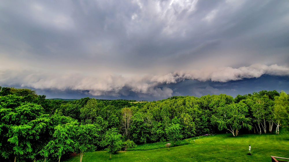 Storm moving across La Crosse County, WI (credit: Dave Lawrence) |
Photos:
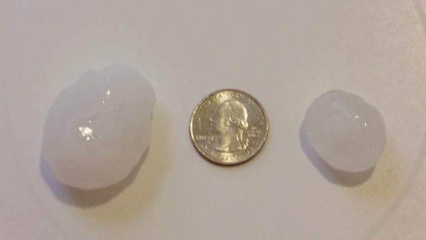
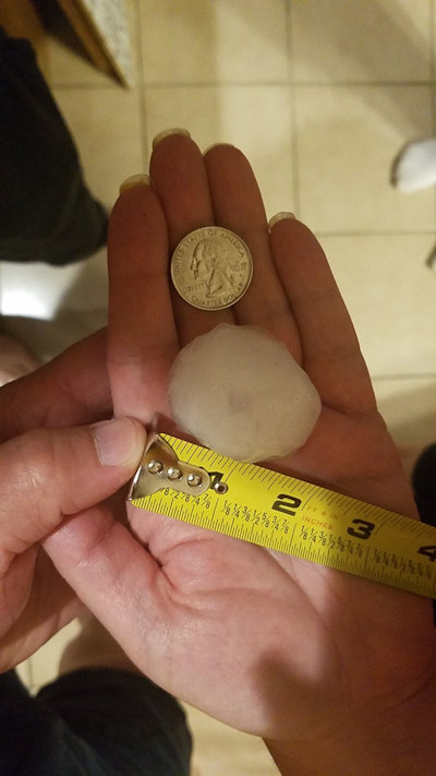
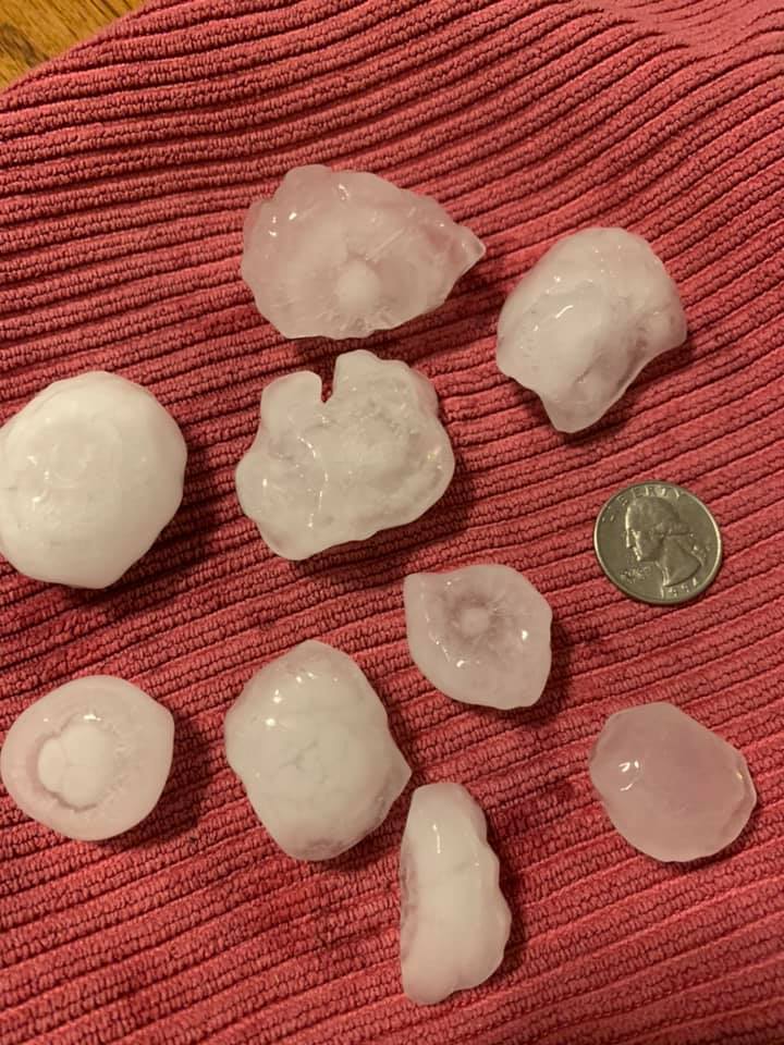
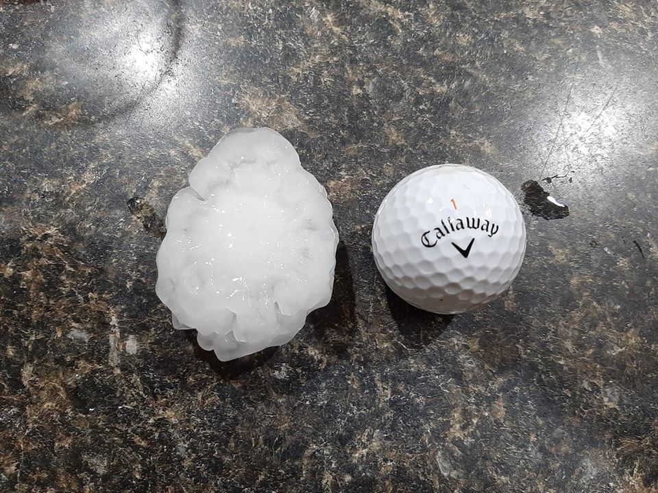
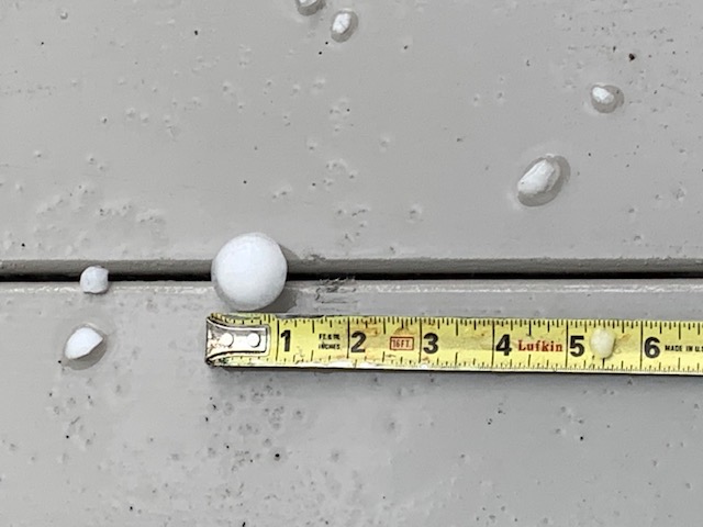
Hail / Damage Images
 |
 |
 |
 |
| Winona, MN (credit:Ben White) |
Winona, MN |
Holmen, WI (credit: Stu Ireland) |
Town of Holland, WI (credit: Ryan Malak) |
 |
 |
 |
 |
| Holmen, WI (credit: Tony Decker) |
Holmen, WI (credit: Patrick Barlow) |
Holmen, WI (credit: Megan Hubbard) |
Damage at the Monroe Co. Fairgrounds in Tomah, WI (credit: Monroe Co. EM) |
 |
|||
| Winona, MN (credit: D Fakler) |
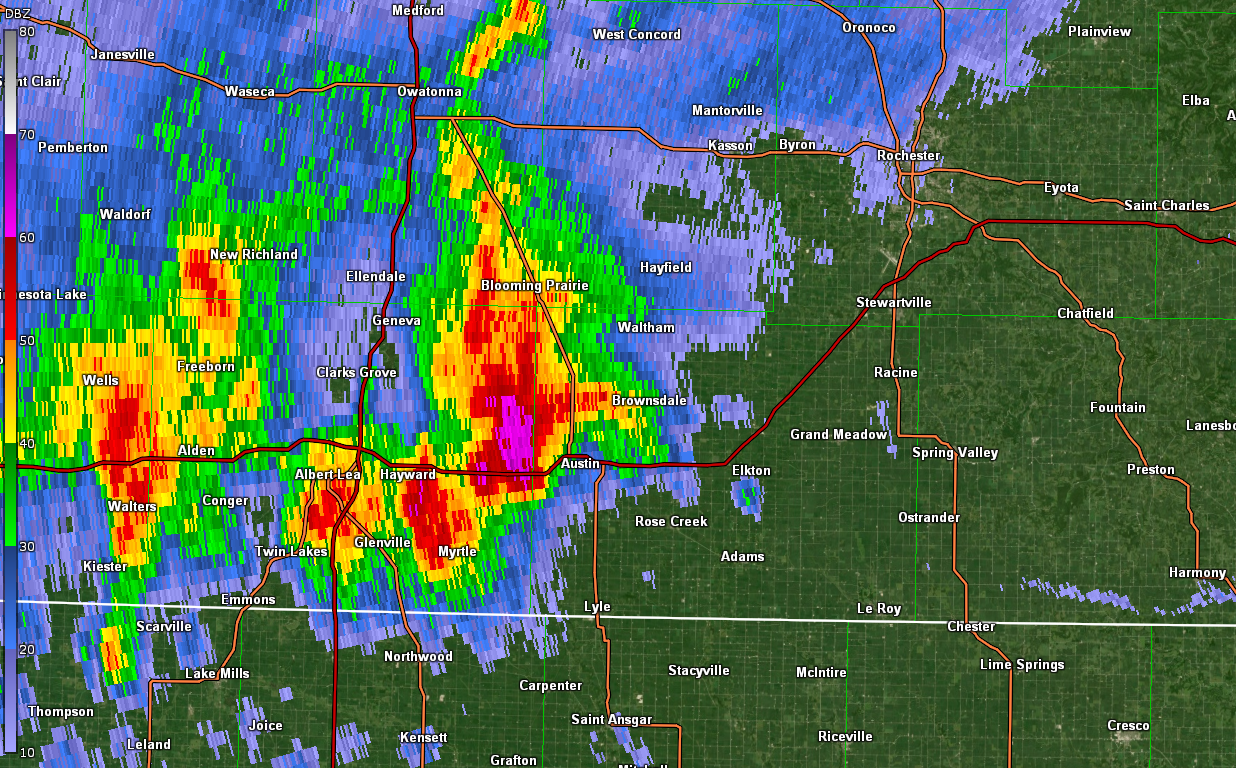
Radar:
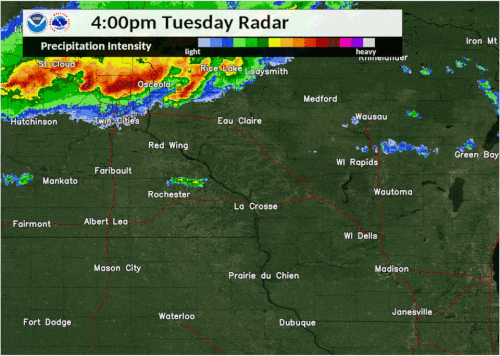 |
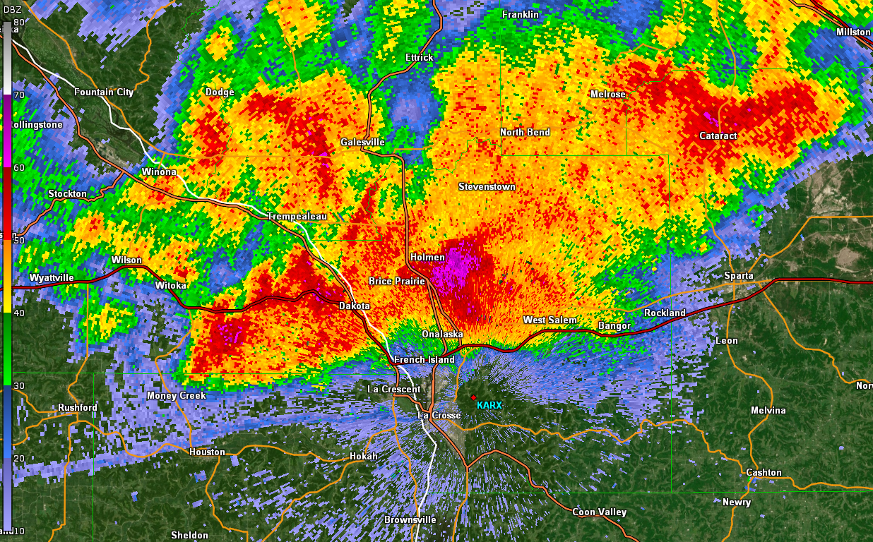 |
 |
|
| Radar from 3 to 7 p.m. | A view of radar from 6:28 p.m. as storms hit the Holmen / Onalaska, WI areas. | A view of radar from 6:59 p.m. as storms approached the Austin, MN area. |
Storm Reports
PRELIMINARY LOCAL STORM REPORT...SUMMARY
NATIONAL WEATHER SERVICE LA CROSSE WI
832 AM CDT THU JUN 4 2020

..TIME...   ...EVENT...      ...CITY LOCATION...     ...LAT.LON...
..DATE...   ....MAG....      ..COUNTY LOCATION..ST.. ...SOURCE....
            ..REMARKS..

0435 PM     Hail             5 NNW ELBA              44.15N 92.05W
06/02/2020  E0.88 inch       Winona             MN   Public

            RELAYED VIA SOCIAL MEDIA.

0508 PM     Hail             1 W WINONA              44.05N 91.68W
06/02/2020  E0.70 inch       Winona             MN   Public

            RELAYED VIA SOCIAL MEDIA.

0517 PM     Hail             WINONA                  44.05N 91.66W
06/02/2020  M1.75 inch       Winona             MN   Amateur Radio

            .

0520 PM     Hail             WINONA                  44.05N 91.66W
06/02/2020  E1.75 inch       Winona             MN   Public

            RELAYED VIA SOCIAL MEDIA.

0520 PM     Hail             1 E Winona              44.05N 91.64W
06/02/2020  E1.50 inch       Winona             MN   Public

            relayed via social media. Time estimated
            from radar.

0520 PM     Hail             WINONA                  44.05N 91.66W
06/02/2020  E1.50 inch       Winona             MN   Public

            RELAYED VIA PHONE.

0520 PM     Hail             2 SE Winona             44.03N 91.62W
06/02/2020  E1.50 inch       Winona             MN   Public

            relayed via social media. Time estimated
            from radar.

0520 PM     Hail             WINONA                  44.05N 91.66W
06/02/2020  E1.50 inch       Winona             MN   Public

            RELAYED VIA PHONE.

0530 PM     Hail             4 ENE Pickwick          44.01N 91.54W
06/02/2020  M2.00 inch       Winona             MN   Public

            via social media.

0532 PM     Hail             1 E WINONA              44.05N 91.64W
06/02/2020  M1.25 inch       Winona             MN   Public

            .

0535 PM     Hail             3 WSW PRAY              44.36N 90.55W
06/02/2020  M1.75 inch       Jackson            WI   Public

            CORRECTED TIME ON REPORT.

0536 PM     Hail             PICKWICK                43.98N 91.60W
06/02/2020  E1.75 inch       Winona             MN   Public

            .

0540 PM     Hail             1 S WINONA              44.03N 91.66W
06/02/2020  E1.75 inch       Winona             MN   Trained Spotter

            .

0543 PM     Hail             5 E PICKWICK            43.98N 91.50W
06/02/2020  M2.00 inch       Winona             MN   Fire Dept/Rescue

            RELAYED VIA EM.

0545 PM     Hail             Pickwick                43.98N 91.60W
06/02/2020  E2.00 inch       Winona             MN   Public

            relayed via social media. Time estimated
            from radar.

0550 PM     Hail             TREMPEALEAU             44.01N 91.44W
06/02/2020  E1.00 inch       Trempealeau        WI   Public

            RELAYED VIA SOCIAL MEDIA PHOTO.

0559 PM     Tstm Wnd Dmg     HATFIELD                44.42N 90.73W
06/02/2020                   Jackson            WI   Law Enforcement

            SEEVRAL LARGE TREES WERE BLOWN DOWN.

0605 PM     Tstm Wnd Dmg     Merrillan               44.45N 90.84W
06/02/2020                   Jackson            WI   Public

            Several large trees blown down.

0605 PM     Hail             TREMPEALEAU             44.01N 91.44W
06/02/2020  M1.25 inch       Trempealeau        WI   Law Enforcement

            .

0605 PM     Tstm Wnd Dmg     TAYLOR                  44.32N 91.12W
06/02/2020                   Jackson            WI   Law Enforcement

            SEVERAL LARGE BRANCHES AND TREES BLOWN DOWN.

0606 PM     Hail             3 S NEILLSVILLE         44.51N 90.60W
06/02/2020  E0.70 inch       Clark              WI   Public

            RELAYED VIA PHONE.

0608 PM     Hail             New Amsterdam           43.99N 91.32W
06/02/2020  E2.50 inch       La Crosse          WI   Public

            via social media photo. Estimated around 2.5
            inches, but could be slightly larger. Time
            estimated from radar.

0610 PM     Hail             2 SW DODGE              44.11N 91.58W
06/02/2020  M1.75 inch       Buffalo            WI   Public

            .

0611 PM     Tstm Wnd Dmg     BLAIR                   44.30N 91.23W
06/02/2020                   Trempealeau        WI   Public

            SEVERAL TREES BLOWN DOWN.

0615 PM     Hail             HOLMEN                  43.96N 91.26W
06/02/2020  E1.25 inch       La Crosse          WI   NWS Employee

            .

0615 PM     Tstm Wnd Dmg     3 SSE LA CROSSE         43.79N 91.22W
06/02/2020                   La Crosse          WI   Public

            LARGE TREE BRANCH DOWN. RELAYED VIA SOCIAL
            MEDIA.

0615 PM     Tstm Wnd Dmg     NEILLSVILLE             44.56N 90.59W
06/02/2020                   Clark              WI   CO-OP Observer

            LARGE BRANCHES DOWN.

0620 PM     Hail             1 WSW WEST SALEM        43.90N 91.10W
06/02/2020  M1.00 inch       La Crosse          WI   Trained Spotter

            .

0620 PM     Hail             HOLMEN                  43.97N 91.26W
06/02/2020  E1.25 inch       La Crosse          WI   Public

            RELAYED VIA SOCIAL MEDIA. PHOTO OF QUARTER
            TO HALF DOLLAR SIZED HAIL STONES.

0622 PM     Tstm Wnd Dmg     1 SW ONALASKA           43.88N 91.23W
06/02/2020                   La Crosse          WI   Public

            .

0625 PM     Hail             HOLMEN                  43.96N 91.26W
06/02/2020  E2.50 inch       La Crosse          WI   Public

            VIA SOCIAL MEDIA PHOTO. ESTIMATED AROUND 2.5
            INCHES. TIME ESTIMATED FROM RADAR.

0627 PM     Tstm Wnd Gst     LA CROSSE REGIONAL AIRP 43.88N 91.25W
06/02/2020  M58 MPH          La Crosse          WI   ASOS

            CORRECTED FROM NON-TSTM WND GST TO TSTM WIND
            GUST. ASOS STATION KLSE LA CROSSE REGIONAL
            AIRPORT.

0630 PM     Hail             HOLMEN                  43.96N 91.26W
06/02/2020  M2.00 inch       La Crosse          WI   Public

            RELAYED VIA SOCIAL MEDIA PHOTO WITH RULER.

0630 PM     Hail             HOLMEN                  43.96N 91.26W
06/02/2020  E1.50 inch       La Crosse          WI   Public

            RELAYED VIA SOCIAL MEDIA PHOTO.

0632 PM     Tstm Wnd Dmg     4 NE MONROE CENTER      44.17N 89.89W
06/02/2020                   Adams              WI   Law Enforcement

            POWERLINES BLOWN DOWN ON COUNTY RD Z.

0633 PM     Tstm Wnd Gst     ONALASKA                43.89N 91.21W
06/02/2020  M59 MPH          La Crosse          WI   Public

            .

0635 PM     Hail             HOLMEN                  43.96N 91.26W
06/02/2020  E1.25 inch       La Crosse          WI   Public

            REPORT RELAYED VIA SOCIAL MEDIA.

0635 PM     Tstm Wnd Dmg     5 ESE New Rome          44.22N 89.79W
06/02/2020                   Adams              WI   Law Enforcement

            5 large trees blown down.

0635 PM     Tstm Wnd Dmg     2 ESE LA CROSSE         43.81N 91.20W
06/02/2020                   La Crosse          WI   NWS Employee

            TWO LARGE LIMBS DOWN ON BLISS ROAD,
            PARTIALLY BLOCKING DOWNHILL LANE. TIME
            ESTIMATED FROM RADAR.

0636 PM     Hail             DAKOTA                  43.91N 91.36W
06/02/2020  E1.75 inch       Winona             MN   Law Enforcement

            .

0640 PM     Tstm Wnd Dmg     SPARTA                  43.94N 90.81W
06/02/2020                   Monroe             WI   Law Enforcement

            NUMEROUS TREES AND POWER LINES REPORTED DOWN
            ACROSS THE COUNTY FROM EARLIER STORM. TIME
            ESTIMATED FROM RADAR.

0640 PM     Hail             HOLMEN                  43.96N 91.26W
06/02/2020  E1.50 inch       La Crosse          WI   Public

            RELAYED VIA SOCIAL MEDIA.

0640 PM     Tstm Wnd Dmg     Houston                 43.76N 91.57W
06/02/2020                   Houston            MN   Public

            3 trees fell onto a house.

0640 PM     Tstm Wnd Dmg     MOUND PRAIRIE           43.78N 91.45W
06/02/2020                   Houston            MN   Public

            POWER LINES DOWN.

0641 PM     Hail             2 SSE HOLMEN            43.93N 91.24W
06/02/2020  E1.00 inch       La Crosse          WI   NWS Employee

            .

0645 PM     Tstm Wnd Dmg     Coon Valley             43.70N 91.01W
06/02/2020                   Vernon             WI   Public

            2 large pine trees blown down.

0646 PM     Tstm Wnd Dmg     1 S TOMAH               43.97N 90.50W
06/02/2020                   Monroe             WI   Trained Spotter

            DAMAGE TO TREES, ROOFS, AND SIDING.

0646 PM     Tstm Wnd Dmg     2 SSW TOMAH             43.97N 90.52W
06/02/2020                   Monroe             WI   NWS Storm Survey

            CANOPY BLOWN OFF TOP OF GRANDSTAND AT COUNTY
            FAIRGROUNDS. LOTS OF TREE DAMAGE IN AREA AS
            WELL.

0650 PM     Tstm Wnd Dmg     FRIENDSHIP              43.97N 89.82W
06/02/2020                   Adams              WI   Public

            SEVERAL TREES AND LARGE BRANCHES BLOWN DOWN.

0650 PM     Tstm Wnd Dmg     5 NNE STODDARD          43.72N 91.17W
06/02/2020                   Vernon             WI   NWS Employee

            LARGE TREE DOWN AND OTHER BRANCHES.

0652 PM     Tstm Wnd Gst     2 NE MOUND PRAIRIE      43.81N 91.42W
06/02/2020  M57 MPH          Houston            MN   Public

            .

0656 PM     Hail             1 NW LA CRESCENT        43.83N 91.31W
06/02/2020  E0.50 inch       Houston            MN   Public

            .

0658 PM     Heavy Rain       2 NW ONALASKA           43.91N 91.23W
06/02/2020  M1.77 inch       La Crosse          WI   Public

            .

0700 PM     Tstm Wnd Dmg     ELROY                   43.74N 90.27W
06/02/2020                   Juneau             WI   Public

            SEVERAL LARGE TREES AND BRANCHES WERE BLOWN
            DOWN IN THE COMMUNITY. A COUPLE OF THESE
            LARGE BRANCHES FELL ONTO A TRUCK.

0705 PM     Tstm Wnd Dmg     AUSTIN                  43.67N 92.97W
06/02/2020                   Mower              MN   Broadcast Media

            NUMEROUS TREES AND LIMBS REPORTED DOWN
            ACROSS WESTERN MOWER COUNTY FROM EARLIER
            STORMS. ALSO AN OVERTURNED SEMI NORTH OF
            AUSTIN. TIME ESTIMATED FROM RADAR.

0707 PM     Tstm Wnd Gst     HARMONY                 43.55N 92.01W
06/02/2020  E50 MPH          Fillmore           MN   Public

            .

0715 PM     Heavy Rain       1 NE BARRE MILLS        43.85N 91.11W
06/02/2020  M1.20 inch       La Crosse          WI   Public

            .

0717 PM     Tstm Wnd Gst     3 ENE WHITE CREEK       43.84N 89.79W
06/02/2020  E60 MPH          Adams              WI   Public

            ESTIMATED 60-65 MPH WINDS. LARGE OAK TREE
            NEARLY BENT TO THE GROUND PER REPORT. TIME
            ESTIMATED FROM RADAR.

0722 PM     Tstm Wnd Dmg     Gays Mills              43.32N 90.84W
06/02/2020                   Crawford           WI   Public

            Several large trees blown down.

0727 PM     Tstm Wnd Dmg     1 S RICHLAND CENTER     43.32N 90.38W
06/02/2020                   Richland           WI   Public

            VERY LARGE TREE BRANCH BLOWN DOWN, THOUGH
            MAY HAVE BEEN DUE TO TREE PROBLEM. WINDS
            ESTIMATED AROUND 50 MPH. TIME BASED ON
            RADAR.

0748 PM     Heavy Rain       1 WNW NECEDAH           44.03N 90.08W
06/02/2020  M1.08 inch       Juneau             WI   Mesonet

            MESONET STATION NEHW3 NECEDAH.

0755 PM     Tstm Wnd Dmg     SAINT ANSGAR            43.38N 92.92W
06/02/2020                   Mitchell           IA   Public

            SEVERAL LARGE TREES AND BRANCHES BLOWN DOWN.

0800 PM     Tstm Wnd Gst     RICHLAND CENTER         43.34N 90.38W
06/02/2020  E50 MPH          Richland           WI   Public

            ESTIMATED WIND GUSTS OF 40-50 MPH.

0805 PM     Tstm Wnd Dmg     STACYVILLE              43.44N 92.78W
06/02/2020                   Mitchell           IA   Law Enforcement

            A POWERLINE BLOWN DOWN.

0810 PM     Tstm Wnd Gst     2 SSW CUMMINGSVILLE     43.85N 92.29W
06/02/2020  E60 MPH          Olmsted            MN   Trained Spotter

            .

0815 PM     Heavy Rain       1 NNW ONALASKA          43.90N 91.23W
06/02/2020  M1.60 inch       La Crosse          WI   Public

            .

0836 PM     Tstm Wnd Gst     WADENA                  42.84N 91.66W
06/02/2020  M35 MPH          Fayette            IA   Trained Spotter

            .

0837 PM     Tstm Wnd Dmg     2 NE GENOA              43.59N 91.21W
06/02/2020                   Vernon             WI   Public

            .

0853 PM     Heavy Rain       AUSTIN                  43.67N 92.97W
06/02/2020  E1.65 inch       Mower              MN   Public

            RELAYED VIA SOCIAL MEDIA.

1002 PM     Lightning        2 E ROCHESTER           44.01N 92.44W
06/02/2020                   Olmsted            MN   Fire Dept/Rescue

            LIGHTNING STARTED A FIRE AT THE EASTGATE
            APARTMENTS. TIME BASED ON FIRE DEPARTMENT
            INFORMATION.

0602 AM     Heavy Rain       WAUKON                  43.27N 91.48W
06/03/2020  M1.00 inch       Allamakee          IA   Broadcast Media

            .


&&

$$
Rain Reports
Public Information Statement
National Weather Service La Crosse WI
954 AM CDT Wed Jun 3 2020

...Rainfall Amounts the Past 24 Hours...

Location                     Amount    Time/Date       Lat/Lon

...Iowa...

...Allamakee County...
Harpers Ferry 6.4 SSW        1.59 in   0700 AM 06/03   43.11N/91.20W
Postville 5.5 NE             1.41 in   0700 AM 06/03   43.14N/91.49W
Monona 9.8 N                 1.26 in   0645 AM 06/03   43.19N/91.35W
Lansing 4.1 NW               1.21 in   0700 AM 06/03   43.40N/91.29W
Waukon                       1.00 in   0602 AM 06/03   43.27N/91.48W
Waukon                       0.88 in   0630 AM 06/03   43.27N/91.47W
5 SW Waukon Jct              0.82 in   0830 AM 06/03   43.11N/91.27W
3 S Dorchester               0.79 in   0845 AM 06/03   43.42N/91.51W

...Chickasaw County...
New Hampton 0.4 SW           0.10 in   0700 AM 06/03   43.06N/92.32W
Ionia 2W                     0.10 in   0600 AM 06/03   43.03N/92.50W
New Hampton                  0.07 in   0940 AM 06/03   43.06N/92.32W

...Clayton County...
Mcgregor                     1.44 in   0939 AM 06/03   43.02N/91.19W
1 WSW Marquette              0.97 in   0730 AM 06/03   43.04N/91.21W
Monona                       0.80 in   0939 AM 06/03   43.04N/91.39W
Big Spring Fish Hatchery     0.17 in   0615 AM 06/03   42.91N/91.47W
Guttenberg Dam 10            0.15 in   0800 AM 06/03   42.79N/91.10W
Elkader 6SSW                 0.09 in   0700 AM 06/03   42.78N/91.45W
Garber                       0.05 in   0715 AM 06/03   42.74N/91.26W
Volga 1NE                    0.04 in   0601 AM 06/03   42.81N/91.52W
Littleport                   0.03 in   0800 AM 06/03   42.75N/91.37W
Strawberry Point             0.01 in   0700 AM 06/03   42.69N/91.53W

...Fayette County...
Eldorado 1E - Turkey River   0.28 in   0530 AM 06/03   43.05N/91.81W
Waucoma 1 WNW                0.25 in   0700 AM 06/03   43.06N/92.05W
Fayette                      0.05 in   0645 AM 06/03   42.88N/91.83W

...Floyd County...
Charles City                 0.03 in   0700 AM 06/03   43.06N/92.67W
Nora Springs 2.4 SSE         0.02 in   0700 AM 06/03   43.11N/92.99W
Nashua 2SW                   0.02 in   0700 AM 06/03   42.94N/92.57W

...Howard County...
Saratoga                     0.91 in   0931 AM 06/03   43.35N/92.42W
Riceville                    0.91 in   0931 AM 06/03   43.36N/92.48W
Elma                         0.51 in   0700 AM 06/03   43.24N/92.44W

...Mitchell County...
Osage 4.7 E                  1.04 in   0700 AM 06/03   43.28N/92.72W
Osage                        0.72 in   0700 AM 06/03   43.28N/92.81W
St Ansgar                    0.60 in   0630 AM 06/03   43.38N/92.92W

...Winneshiek County...
Decorah 4.9SE                0.94 in   0700 AM 06/03   43.26N/91.70W
7 ENE Decorah                0.75 in   0731 AM 06/03   43.34N/91.64W
1 ENE Bluffton               0.62 in   0815 AM 06/03   43.41N/91.90W
Spillville                   0.28 in   0800 AM 06/03   43.21N/91.95W

...Minnesota...

...Dodge County...
Hayfield                     0.37 in   0937 AM 06/03   43.89N/92.85W
Hayfield 0.3 SSE             0.36 in   0600 AM 06/03   43.89N/92.85W
Claremont 2.5 ESE            0.05 in   0800 AM 06/03   44.04N/92.95W

...Fillmore County...
Lanesboro                    0.77 in   0615 AM 06/03   43.72N/91.98W
Preston                      0.60 in   0700 AM 06/03   43.67N/92.07W
Mabel                        0.59 in   0630 AM 06/03   43.52N/91.76W
Spring Valley                0.52 in   0700 AM 06/03   43.69N/92.39W
Preston 3.2 NNE              0.52 in   0630 AM 06/03   43.71N/92.05W
Wykoff 3.1 NW                0.50 in   0700 AM 06/03   43.74N/92.31W
1 NNW Fillmore               0.49 in   0645 AM 06/03   43.76N/92.27W
Chatfield 9.0 ESE            0.40 in   0700 AM 06/03   43.79N/92.03W
Preston Airport              0.32 in   0935 AM 06/03   43.68N/92.17W
2 S Pilot Mound              0.23 in   0900 AM 06/03   43.78N/92.03W

...Houston County...
La Crescent 0.7 WNW          1.50 in   0700 AM 06/03   43.84N/91.31W
La Crescent 1.0 WSW          1.13 in   0700 AM 06/03   43.83N/91.32W
Mound Prairie                0.96 in   0800 AM 06/03   43.78N/91.45W
Mabel 2.7 E                  0.94 in   0800 AM 06/03   43.51N/91.71W
1 SSE Brownsville            0.93 in   0715 AM 06/03   43.69N/91.27W
Caledonia 5.4 S              0.83 in   0800 AM 06/03   43.56N/91.51W
Caledonia                    0.78 in   0700 AM 06/03   43.63N/91.50W
Hokah 4 NW                   0.69 in   0700 AM 06/03   43.80N/91.43W
La Crescent 5.4 SW           0.64 in   0700 AM 06/03   43.78N/91.39W
Houston 6.9 E                0.52 in   0845 AM 06/03   43.76N/91.43W
Houston                      0.51 in   0936 AM 06/03   43.77N/91.58W
1 NNE Houston                0.47 in   0630 AM 06/03   43.77N/91.57W

...Mower County...
Austin 3 NW - Turtle Creek   2.95 in   0800 AM 06/03   43.65N/92.98W
Austin Waste Water Treatment 2.02 in   0700 AM 06/03   43.65N/92.97W
Austin 1.5 WSW               1.90 in   0700 AM 06/03   43.67N/93.00W
Austin 3S - Cedar River      1.76 in   0615 AM 06/03   43.64N/92.97W
Austin 2.4 W                 1.75 in   0657 AM 06/03   43.67N/93.02W
Austin 2.7 W                 1.67 in   0630 AM 06/03   43.68N/93.03W
Austin                       1.65 in   0853 PM 06/02   43.67N/92.97W
Austin 1.9 ENE               1.43 in   0800 AM 06/03   43.68N/92.94W
Dobbins Creek                1.27 in   0615 AM 06/03   43.68N/92.94W
Grand Meadow                 0.84 in   0530 AM 06/03   43.71N/92.56W
Lansing - Cedar River        0.62 in   0615 AM 06/03   43.75N/92.96W
Ostrander 5.1 WNW            0.55 in   0700 AM 06/03   43.65N/92.52W
Austin Municipal Airport     0.02 in   0936 AM 06/03   43.67N/92.92W

...Olmsted County...
Eyota 2NE                    1.13 in   0800 AM 06/03   44.02N/92.20W
2 S Predmore                 0.80 in   0620 AM 06/03   43.90N/92.34W
Elgin 5SE                    0.58 in   0800 AM 06/03   44.08N/92.19W
2 W High Forest              0.53 in   0500 AM 06/03   43.85N/92.59W
Rochester-Beltline Bear Cree 0.44 in   0900 AM 06/03   44.01N/92.45W
Rochester International Airp 0.41 in   0854 AM 06/03   43.90N/92.50W
Rochester 1.5 WSW            0.40 in   0700 AM 06/03   44.00N/92.50W
1 W Chester                  0.39 in   0637 AM 06/03   44.00N/92.38W
Rochester                    0.28 in   0930 AM 06/03   44.04N/92.44W
Rochester 5.8 ENE            0.28 in   0700 AM 06/03   44.05N/92.37W
Rochester Beltline           0.28 in   0600 AM 06/03   44.01N/92.47W
3 ENE Rochester              0.25 in   0845 AM 06/03   44.03N/92.43W
Rochester                    0.24 in   0933 AM 06/03   44.01N/92.49W
5 WSW Rochester              0.24 in   0830 AM 06/03   43.98N/92.56W
4 ESE Douglas                0.23 in   0600 AM 06/03   44.08N/92.51W
3 SE Douglas                 0.20 in   0621 AM 06/03   44.08N/92.53W
Elgin 2SSW                   0.16 in   0700 AM 06/03   44.10N/92.27W
Rochester                    0.15 in   0935 AM 06/03   44.09N/92.49W
4 NNW Rochester              0.15 in   0653 AM 06/03   44.07N/92.49W
Rochester 4.2 N              0.15 in   0600 AM 06/03   44.08N/92.49W
Rochester                    0.13 in   0936 AM 06/03   44.08N/92.52W
Rochester                    0.13 in   0935 AM 06/03   44.09N/92.51W
2 NE Rochester               0.13 in   0600 AM 06/03   44.04N/92.44W
Rochester                    0.12 in   0935 AM 06/03   44.05N/92.45W
2 NNW Rochester              0.12 in   0700 AM 06/03   44.05N/92.49W
Mayo Helipad                 0.11 in   0936 AM 06/03   44.02N/92.48W
3 N Rochester                0.11 in   0800 AM 06/03   44.06N/92.47W
3 W Rochester                0.11 in   0730 AM 06/03   44.02N/92.53W
Rochester-Cascade Creek      0.10 in   0845 AM 06/03   44.03N/92.47W
Rochester 2.0 NNE            0.10 in   0700 AM 06/03   44.04N/92.47W
Byron                        0.08 in   0930 AM 06/03   44.04N/92.64W
Rochester 3.2 WNW            0.08 in   0700 AM 06/03   44.04N/92.53W
Rochester                    0.05 in   0930 AM 06/03   44.18N/92.41W
1 W Oronoco                  0.05 in   0730 AM 06/03   44.17N/92.55W
6 NNW Genoa                  0.03 in   0815 AM 06/03   44.19N/92.65W

...Wabasha County...
1 N Kellogg                  0.33 in   0900 AM 06/03   44.32N/92.00W
Plainview                    0.32 in   0936 AM 06/03   44.17N/92.17W
Wabasha                      0.14 in   0938 AM 06/03   44.30N/92.00W
Lake City 1.0 SE             0.14 in   0800 AM 06/03   44.43N/92.27W
Lake City                    0.07 in   0940 AM 06/03   44.32N/92.44W
Lake City                    0.06 in   0933 AM 06/03   44.44N/92.28W
0.8 SW Lake City             0.06 in   0700 AM 06/03   44.44N/92.28W
Mazeppa 5.4 SSE              0.04 in   0800 AM 06/03   44.20N/92.50W
Zumbro Falls 3.5 SSW         0.03 in   0800 AM 06/03   44.24N/92.46W
3 ESE Mazeppa                0.02 in   0715 AM 06/03   44.26N/92.49W

...Winona County...
La Crescent Dam 7            1.58 in   0600 AM 06/03   43.87N/91.31W
Dakota                       1.44 in   0745 AM 06/03   43.91N/91.36W
Whitewater State Park        1.06 in   0800 AM 06/03   44.05N/92.05W
Winona 12.0 ESE              0.99 in   0700 AM 06/03   43.99N/91.44W
Winona Dam 5A                0.76 in   0800 AM 06/03   44.09N/91.67W
Winona 1.3 SSW               0.76 in   0700 AM 06/03   44.03N/91.68W
Winona 5.1 WSW               0.53 in   0700 AM 06/03   44.03N/91.77W
Stockton                     0.53 in   0640 AM 06/03   44.03N/91.77W
Lewiston 0.2 NW              0.48 in   0700 AM 06/03   43.99N/91.87W
4.2 N Rollingstone           0.41 in   0600 AM 06/03   44.16N/91.81W
Minnesota City 1.1 SE        0.38 in   0700 AM 06/03   44.08N/91.73W
3 SW Elba                    0.37 in   0730 AM 06/03   44.06N/92.05W
Altura 5w                    0.35 in   0700 AM 06/03   44.06N/92.04W
Beaver                       0.32 in   0800 AM 06/03   44.15N/92.00W
Winona Municipal Airport     0.31 in   0935 AM 06/03   44.07N/91.70W
1 WSW Elba                   0.28 in   0730 AM 06/03   44.09N/92.03W
Saint Charles                0.18 in   0940 AM 06/03   43.97N/92.06W

...Wisconsin...

...Adams County...
0.6 W Friendship             1.48 in   0700 AM 06/03   43.98N/89.83W
2.0 NW Strongs Prairie       1.27 in   0730 AM 06/03   44.08N/90.00W
Oxford 4.3 W                 0.96 in   0800 AM 06/03   43.79N/89.65W
Oxford 4.0 W                 0.93 in   0633 AM 06/03   43.79N/89.64W
Grand Marsh 1.0 W            0.85 in   0700 AM 06/03   43.89N/89.73W
Nekoosa 6.6 SSE              0.79 in   0700 AM 06/03   44.22N/89.88W
Nekoosa 8.0 SSE              0.45 in   0800 AM 06/03   44.21N/89.85W

...Buffalo County...
Alma Dam 4                   0.32 in   0600 AM 06/03   44.33N/91.92W
Mondovi 12.1 SSE             0.25 in   0700 AM 06/03   44.40N/91.60W
Dodge                        0.18 in   0530 AM 06/03   44.13N/91.55W

...Clark County...
3.2 E Neillsville            0.49 in   0700 AM 06/03   44.54N/90.53W
Owen 1E                      0.14 in   0700 AM 06/03   44.95N/90.55W

...Crawford County...
0.6 NE Prairie Du Chien      1.69 in   0700 AM 06/03   43.05N/91.13W
2.8 E Harpers Ferry          1.52 in   0600 AM 06/03   43.21N/91.10W
Steuben                      1.38 in   0515 AM 06/03   43.18N/90.86W
Prairie Du Chien 1.4 N       1.29 in   0700 AM 06/03   43.06N/91.14W
Eastman                      1.28 in   0541 AM 06/03   43.17N/91.02W
Gays Mills 6.1 SE            1.26 in   0700 AM 06/03   43.26N/90.76W
Prairie Du Chien  Airport    1.22 in   0935 AM 06/03   43.02N/91.12W
Gays Mills 1.0 NE            1.22 in   0700 AM 06/03   43.33N/90.84W
1 S De Soto                  1.12 in   0543 AM 06/03   43.41N/91.19W
Steuben 4SE                  0.96 in   0733 AM 06/03   43.13N/90.84W
De Soto                      0.12 in   0936 AM 06/03   43.42N/91.19W

...Grant County...
1 W Platteville              1.20 in   0631 AM 06/03   42.74N/90.49W
Platteville                  1.15 in   0930 AM 06/03   42.74N/90.46W
4.3 W Lancaster              1.10 in   0800 AM 06/03   42.83N/90.79W
Platteville 0.3 NE           1.09 in   0700 AM 06/03   42.74N/90.47W
Muscoda                      0.90 in   0940 AM 06/03   43.19N/90.46W
Platteville Municipal Airpor 0.87 in   0935 AM 06/03   42.68N/90.43W
Boscobel                     0.84 in   0903 AM 06/03   43.15N/90.68W
Muscoda 0.5 WSW              0.81 in   0828 AM 06/03   43.18N/90.44W
Boscobel Airport             0.77 in   0853 AM 06/03   43.15N/90.68W
Lancaster                    0.43 in   0841 AM 06/03   42.83N/90.69W

...Jackson County...
Black River Falls 1.7 NNE    0.53 in   0700 AM 06/03   44.32N/90.83W
1 E Black River Falls        0.32 in   0715 AM 06/03   44.30N/90.73W
Black River Falls Area Airpo 0.01 in   0935 AM 06/03   44.25N/90.85W

...Juneau County...
2 N Cloverdale               1.50 in   0500 AM 06/03   44.06N/90.17W
Necedah 5.0 ESE              1.37 in   0700 AM 06/03   43.99N/89.99W
Necedah                      1.26 in   0848 AM 06/03   44.03N/90.08W
0.6 W Necedah                1.19 in   0648 AM 06/03   44.02N/90.08W
New Lisbon                   0.86 in   0915 AM 06/03   43.87N/90.17W
Volk Field                   0.76 in   0856 AM 06/03   43.92N/90.27W
Mauston                      0.75 in   0937 AM 06/03   43.80N/90.07W
Mauston Airport              0.57 in   0935 AM 06/03   43.83N/90.13W

...La Crosse County...
Holmen 2S                    2.36 in   0700 AM 06/03
Onalaska 2N                  2.22 in   0700 AM 06/03   43.91N/91.23W
West Salem 0.7 W             1.69 in   0700 AM 06/03   43.90N/91.10W
La Crosse 4NNW               1.59 in   0730 AM 06/03   43.87N/91.27W
La Crosse 5.3 E              1.23 in   0700 AM 06/03   43.82N/91.13W
Coon Valley 4.5 NNW          1.05 in   0700 AM 06/03   43.76N/91.06W
La Crosse                    1.04 in   0908 AM 06/03   43.82N/91.19W
St. Joseph 3W                1.01 in   0939 AM 06/03   43.80N/91.10W
La Crosse                    1.01 in   0930 AM 06/03   43.77N/91.22W
La Crosse 4.4 SSE            0.94 in   0700 AM 06/03   43.77N/91.21W
La Crosse Regional Airport   0.73 in   0853 AM 06/03   43.88N/91.25W

...Monroe County...
Sparta/Fort McCoy Airport    1.21 in   0935 AM 06/03   43.97N/90.73W
Warrens 4.7 WSW              1.16 in   0700 AM 06/03   44.10N/90.59W
0.5 SW Sparta                1.03 in   0800 AM 06/03   43.94N/90.82W
2 E Cataract                 1.01 in   0938 AM 06/03   44.09N/90.79W
Cashton 3 NNW                0.89 in   0718 AM 06/03   43.79N/90.80W
Cashton 4.8 N                0.69 in   0700 AM 06/03   43.81N/90.76W
Wilton 4.2 E                 0.69 in   0700 AM 06/03   43.81N/90.44W

...Richland County...
1 SSE Richland Center        0.85 in   0939 AM 06/03   43.32N/90.38W
Richland Center 4 N          0.61 in   0700 AM 06/03   43.40N/90.39W

...Taylor County...
0.6 SE Medford               0.16 in   0800 AM 06/03   45.13N/90.34W
3 NE Lublin                  0.13 in   0714 AM 06/03   45.11N/90.69W
Medford 0.8 ENE              0.10 in   0700 AM 06/03   45.14N/90.33W
Medford                      0.09 in   0931 AM 06/03   45.30N/90.30W
Medford Airport              0.08 in   0935 AM 06/03   45.10N/90.30W

...Trempealeau County...
Trempealeau Dam 6            1.12 in   0800 AM 06/03   44.00N/91.44W
Trempealeau 7.6 NNW          0.93 in   0700 AM 06/03   44.11N/91.48W
Galesville 1.0 NE            0.88 in   0600 AM 06/03   44.10N/91.34W
1 NW Trempealeau             0.85 in   0600 AM 06/03   44.03N/91.46W
Galesville 2WSW              0.78 in   0700 AM 06/03   44.07N/91.39W
Trempealeau                  0.70 in   0937 AM 06/03   44.07N/91.51W
Ettrick 4.0 WNW              0.32 in   0708 AM 06/03   44.19N/91.34W

...Vernon County...
Retreat                      1.10 in   0817 AM 06/03   43.45N/91.08W
Genoa Dam 8                  0.67 in   0645 AM 06/03   43.57N/91.23W
Stoddard 4.7 NNE             0.66 in   0700 AM 06/03   43.72N/91.17W
Hillsboro 2 SW               0.66 in   0700 AM 06/03   43.63N/90.38W
Hillsboro 0.5 WSW            0.62 in   0700 AM 06/03   43.65N/90.35W
Viroqua 0.8 ESE              0.52 in   0700 AM 06/03   43.55N/90.87W
0.5 E Viroqua                0.50 in   0700 AM 06/03   43.56N/90.88W
La Farge                     0.40 in   0700 AM 06/03   43.57N/90.63W
Viroqua Municipal Airport    0.31 in   0935 AM 06/03   43.58N/90.90W
La Farge                     0.31 in   0931 AM 06/03   43.60N/90.63W

Observations are collected from a variety of sources with varying
equipment and exposures. We thank all volunteer weather observers
for their dedication. Not all data listed are considered official.

$$
Additional Information
Satellite discussion of June 2nd storms: https://cimss.ssec.wisc.edu/satellite-blog/archives/36990
The Forecast
 |
 |
 |
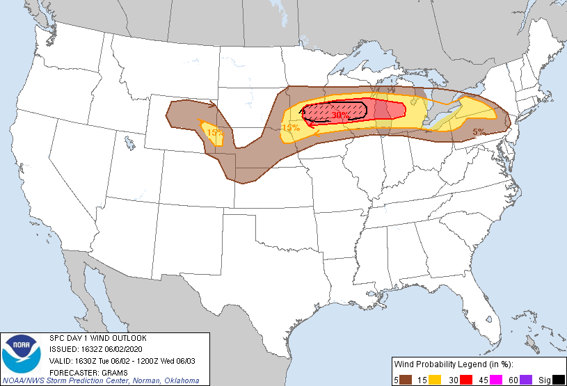 |
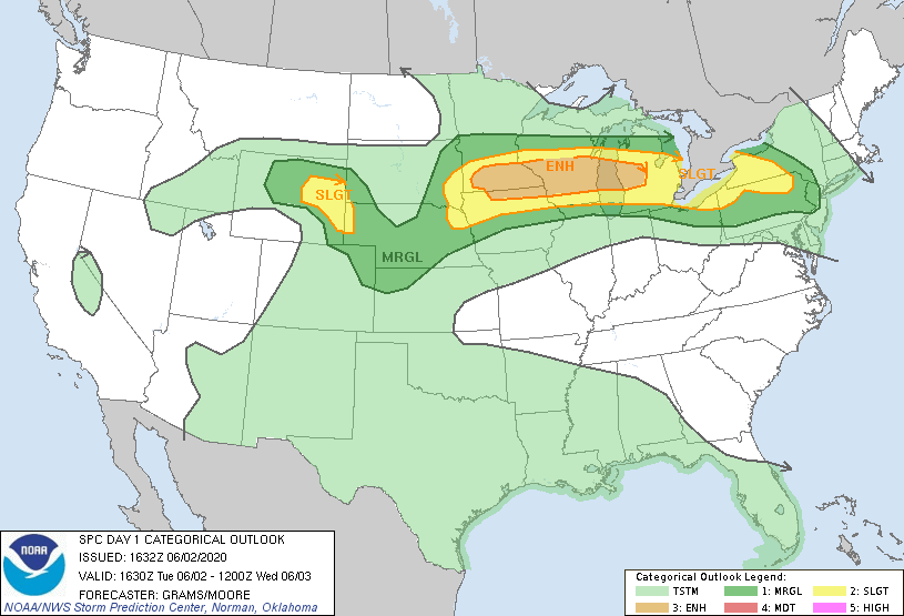
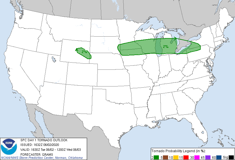
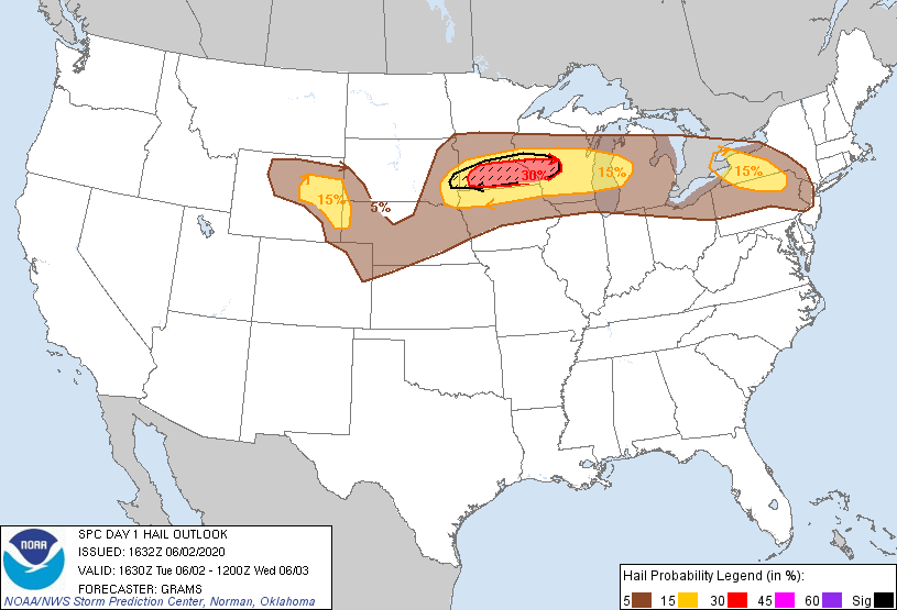
| SPC Day 1 Categorical Outlook | SPC Day 1 Tornado Outlook | SPC Day 1 Hail Outlook | SPC Day 1 Wind Outlook |
 |
 |
 |
|
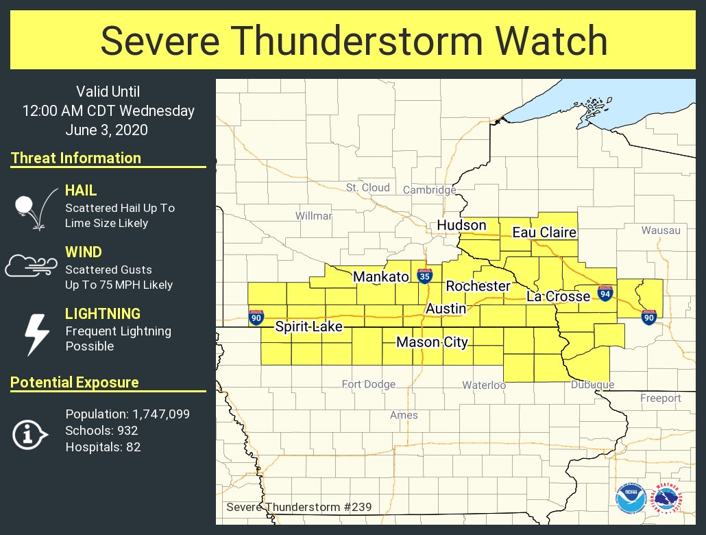
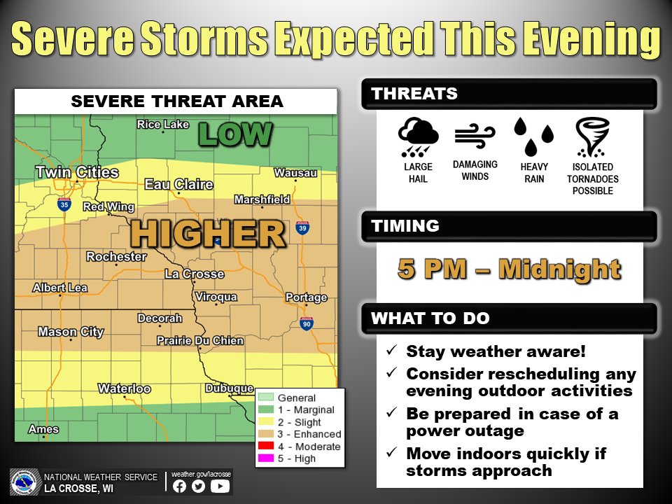
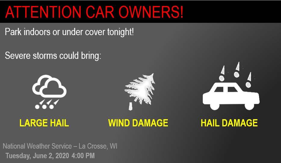
| Severe Thunderstorm Watch that was in effect. | Weather Story graphic | Additional Safety Graphic |
 |
Media use of NWS Web News Stories is encouraged! Please acknowledge the NWS as the source of any news information accessed from this site. |
|


 Weather Story
 Weather Map
 Local Radar