Upper Mississippi River Weather Summary for June 2025:
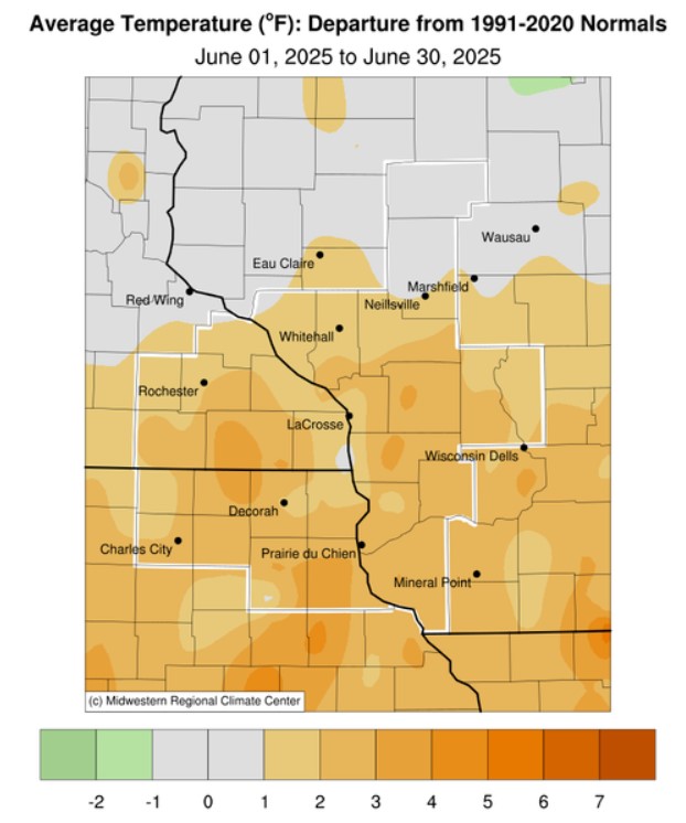
Temperatures - Near to Warmer than Normal
- During June 2025, average temperatures ranged from 63.1°F near Owen, WI (COOP) to 73°F at Guttenberg Lock & Dam 10 (COOP).
- Temperatures were near normal to 4°F warmer than normal.
- The hottest temperature was 97°F on June 21 at La Crosse Regional Airport, WI (ASOS) and the coldest temperature was 34°F on June 1 near Owen, WI (COOP) and Sparta Fort McCoy, WI (ASOS).
|
 |
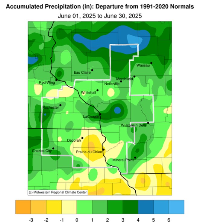
Precipitation - Highly Variable
- Rainfall amounts ranged from 3.05" at Prairie du Chien Municipal Airport, WI (AWOS) to 11.46" near La Crosse, WI (CoCoRaHS).
- Rainfall anomalies ranged from 2" drier than normal to 7" wetter than normal.
- The wettest day was June 23-24 when 5.50" of rain at Tomah Ranger Station 2 (COOP).
|
 |
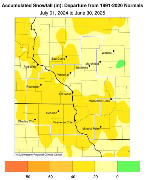
| Seasonal Snowfall - Below Normal |
|
- From July 1, 2024 through June 30, 2025, seasonal snow varied from 11.3" at Alma Dam 4, WI (COOP) to 46" near Medford, WI (CoCoRaHS).
- Snowfall anomalies were up to 40" below normal.
- The snowiest day was March 19-20 when 9.6" of snow fell near Mather, WI (COOP).
|
 |
| Severe Weather - Slightly More than the Longterm Average |
|
- During June 2025, there was 42 severe weather warnings (27 Severe Thunderstorm Warnings, 11 Tornado Warnings, and 2 Flash Flood Warnings). This was 5 warnings more than the 1986-2025 average of 37 warnings.
- There were 9 tornadoes (6 EF0s and 3 EF1s) during the month and they all occurred on June 25. This outbreak was tied with April 12, 2022, for the 6th most in a single calendar day. The greatest number of tornadoes on a single calendar day was December 15, 2021 (27 tornadoes). This was the 3rd most tornadoes in June and the most since June 2004 (16 tornadoes - tied with 1993 for the most in June).This was the most tornadoes in a month since 2024 (14 tornadoes). This was tied for the 9th most tornadoes in a month with June 2008 and April 2022. The greatest in a month was 27 tornadoes in December 2021 (27 torrnadoes).
|
Below are the June 2025 climate summaries for La Crosse, WI, and Rochester, MN.
La Crosse, WI
June 2025 was Wetter and Slightly Warmer than Normal for La Crosse, WI
...June 2025 Highlights...
Temperatures - Slightly Warmer than Normal
- The average temperature at La Crosse Regional Airport was 71.6°F. This was 0.6°F warmer than the 1991-2020 normal of 71°F.
- The average high temperature was 81.2°F. This was 0.5°F cooler than the 1991-2020 normal of 81.7°F.
- The average low temperature was 62°F. This was 1.6°F warmer than the 1991-2020 normal of 60.4°F.
- The warmest high temperature was 97°F on June 21.
- The coldest high temperature was 67°F on June 9.
- The warmest low temperature was 80°F on June 22. Tied with June 29, 1931, for the warmest June low temperature.
- The coldest low temperature was 46°F on June 1.
- The first half of June averaged 66.3°F. This was 2.8°F colder than the 1991-2020 normal of 66.3°F. This was the coldest start to June since 2013 (63.8°F). The coldest first half occurred in 1945 when the average was 58.2°F.
- The second half of June averaged 76.8°F. This was 3.8°F warmer than the 1991-2020 normal of 73°F. This was the 9th warmest second half of June and the warmest since 1995 (78.8°F). The warmest second half occurred in 1933 when the average was 80.1°F.
|
Precipitation - Wetter than Normal
- A total of 6.27" of rain fell at La Crosse Regional Airport. This was 1.19" wetter than the 1991-2020 normal of 5.08". 70.8 percent of this rain fell in just 4 days (June 23-26).
- The wettest day occurred on June 23 when 1.84" of rain fell.
- Measurable rain fell on 17 days and a trace of rain fell on another 5 days. The 22 days with rain is tied with 1935 (17 days with measurable rain and 5 days with a trace) for the second most in June. The most was in 2024 when it rained on 24 days (16 days with measurable rain and 8 days with a trace).
Seasonal Snow - 8th Least
- From July 1, 2024 through June 30, 2025, the snow observer near La Crosse Regional Airport measured 22.6" of snow.
- This was 23.7" below the 1991-2020 normal of 46.3".
- This was the 8th least for a snow season and the least since the 2011-12 snow season (21.5" - 6th least).
- This was the second snow season in a row to see well-below-normal snow. During the 2023-2024 snow season, 26" of snow fell (12th least).
- The lowest seasonal snow total was 7.7" in 1967-68. Below are the 10 least seasonal snows for La Crosse, WI.
Lowest Seasonal Snowfall Totals
in La Crosse, WI
1897-2025
Rank Snowfall Season
---- -------- ------
1 7.7 inches 1967-1968
2 18.8 inches 1953-1954
3 19.4 inches 1975-1976
4 20.0 inches 1965-1966
5 20.5 inches 1913-1914
6 21.5 inches 2011-2012
7 21.8 inches 1980-1981
8 22.0 inches 2024-2025
9 24.7 inches 1957-1958
10 24.9 inches 1956-1957
- The snowiest calendar day was 6.6 inches on December 19.
- Measurable snow fell on 19 days and a trace fell on another 31 days.
Other - First Tornado in La Crosse County since 2022
On June 25, 2 tornadoes were observed in La Crosse County. The first tornado developed near State Highway 33 several miles south of Barre Mills, causing extensive tree damage to the Valleywood Springs area before moving northeast, causing additional spotty tree damage before dissipating near the intersection of County Highways M and I. Valleywood Springs would be affected by a second tornado around 10 minutes later. Each tornado had a distinct circulation and debris signature on radar. These were the first tornadoes in La Crosse County since July 23, 2022.
...June 2025 Records...
Daily Records...
- June 21 - Warmest Low Temperature (79°F) - Previous record was 74°F in 1943
- June 21 - Warmest Daily Average Temperature (88°F) - Previous record was 85°F in 1943
- June 22 - Warmest Low Temperature (80°F) - Previous record was 75°F in 1983
- June 22 - Warmest Daily Average Temperature (88°F) - Previous record was 84.5°F in 1983
June Records...
- Tied the warmest June low temperature (80°F - June 22) with June 29, 1931. Only 3 calendar days have had warmer low temperatures (all with a low temperature of 81°F). They were on July 21, 1901; July 13, 1995; and July 4, 2012.
- This was the third time this year in which a monthly record was tied or broken. The other 2 times were...
- Warmest January High Temperature (58°F on January 30) - Previous record was 57°F on January 3, 1874; January 1, 1897; and January 25, 1981.
- Warmest March High Temperature (86°F on March 28) - Previous record was 84°F on March 29, 1986.
...Looking ahead to July...
- The normal high temperature in La Crosse is 85.4°F and the normal low temperature is 64.5°F. The normal monthly mean temperature is 75.0°F. La Crosse’s hottest July occurred in 2012 with an average temperature of 79.6°F and their coldest July occurred in 1891 with an average of 66.9°F.
- For July, the hottest temperature was 108°F (also the hottest temperature for any day of the year) on July 14, 1936, and July 13, 1995, and the coldest temperature was 44°F on July 4, 1967. There are typically 7 days with temperatures at or above 90°F.
- The normal precipitation for July is 4.23". The wettest July occurred in 1883 when 11.03" of rain fell and the driest occurred in 1967 when 0.16" of rain fell. The wettest July day was 5.24" on July 27, 1987. Normally, there are 7 days with thunderstorms.
Rochester, MN
June 2025 was Warmer and Wetter than Normal at Rochester, MN
...June 2025 Highlights...
Temperatures - 20th Warmest
- The average temperature at Rochester International Airport was 69.7°F. This was 2.2°F warmer than the 1991-2020 normal of 67.5°F. 7 out of the 20 warmest Junes have occurred since 2005. This was the warmest June since 2023 (69.9°F - tied for the 17th warmest with 1943 and 2020). 4 of these have occurred since 2018 (2018, 2020, 2021, and 2023).
- The average high temperature was 79°F. This was 1.4°F warmer than the 1991-2020 normal of 77.6°F.
- The average low temperature was 60.3°F. This was 2.8°F warmer than the 1991-2020 normal of 57.5°F. This was tied with 1949 for the 8th warmest. It was the warmest since 2021 (61.3° - tied for the second warmest since 2018).
- The warmest high temperature was 90°F on June 2, June 21, and June 22.
- The coldest high temperature was 66°F on June 9.
- The warmest low temperature was 75°F on June 21 and June 22.
- The coldest low temperature was 50°F on June 9 and June 10.
|
Precipitation - Tied for the 22nd Wettest
- A total of 6.38" of rain fell at Rochester International Airport.
- This was 1.03" wetter than the 1991-2020 normal of 5.35".
- This was tied for the 22nd wettest with 1920 and 2018 and the wettest since 2024 (9.86" - 3rd wettest).
- 11 out of the 25 wettest Junes have occurred since 2000.
- The wettest day occurred on June 26 when 1.77" of rain fell.
- Measurable rain fell on 18 days and a trace of rain fell on another 3 days.
Seasonal Snow (July 1-June 30) - 13th Least
- From July 1, 2024 through June 30, 2025, the snow observer near Rochester International Airport measured 23.6" of snow.
- This was 29.5" below the 1991-2020 normal of 53.1".
- This was the 13th least for a snow season and the least since the 2011-12 snow season (20.6" - 8th least).
- This was the second consecutive snow season to see well-below-normal snow. During the 2023-2024 snow season, 24" of snow fell (14th least).
- The lowest seasonal snow total was 9.1" in 1967-68.
- The snowiest calendar day was 5.9" on December 19.
- Measurable snow fell on 19 days and a trace fell on another 30 days.
...June 2025 Records...
Daily Records...
- June 21 - Warmest Low Temperature (75°F) - Previous record was 72°F in 1943
- June 22 - Warmest Low Temperature (75°F) - Previous record was 71°F in 1983
...Looking ahead to July...
- The normal high temperature in Rochester is 80.3°F and the normal low temperature is 60.8°F. The normal monthly mean temperature is 70.5°F. Rochester’s hottest July occurred in 1936 with an average temperature of 77.7°F, and its coldest July occurred in 1992 with an average temperature of 64.2°F.
- For July, the hottest temperature was 108°F on July 14, 1936 (also the hottest temperature for any day of the year), and the coldest temperature was 40°F on July 17, 1911. There are typically 2 days with temperatures at or above 90°F. There are typically 2 days with temperatures at or above 90°F.
- The normal precipitation for July is 4.19". The wettest July occurred in 1978 when 12.33" of rain fell and the driest occurred in 1946 when 0.41" of rain fell. The wettest July day was 7.47" on July 11, 1981. Normally, there are 7 days with thunderstorms.


 Weather Story
 Weather Map
 Local Radar