|
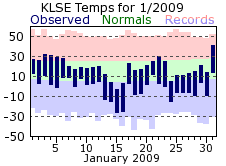
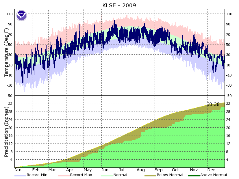
January got 2009 off to a chilly start, with temperatures on 24 of the 31 days averaging below normal. The middle part of the month was particularly frigid as low temperatures tumbled well below zero on the 13th through the 16th. The coldest day was on the 15th when morning lows fell to 26 below zero and highs rose to only -3. Overall, there were 15 days with lows at or below zero and the 8.8 degree average temperature was the coldest since 1994. Snowfall for the month was close to the January normal, with 10.1 inches falling. Half of this came on the 12th, with eight other days recording a tenth of an inch or better. There was an icing event on the 3rd and 4th as freezing drizzle was widespread across the region. While accumulations were relatively small, the icing that occurred made for very treacherous travel.
|
 |
| |
|
|
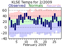
February’s average temperature was right around its normal, but rather misleading as there was plenty of variance throughout the month. Highs topped 40 degrees on 6 days, reaching 50 or greater twice. However, highs were only in the teens on 4 days. Meanwhile, the coldest low for the month was -10 on the 4th, while the warmest was closer to a normal high at 38 degree on the 10th. Precipitation and snowfall were also right on the February normal, but like the temperatures, this too is misleading. Measurable snow did not fall until the 18th while the bulk of the monthly total came on the 21st when 4.5 inches fell. Overall, there were only 4 days with measurable snowfall. Some thunder was heard in February though, with a few rumbles on the 26th.
|
 |
| |
|
|
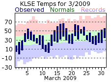
March was similar to February in that its average temperature for the month was right on its normal, yet there were appreciable swings from cold to mild conditions. There were 7 days that averaged 10 degrees or more below normal. Conversely, average temperatures were 10 degrees or greater above normal 8 times. Highs failed to crack 20 degrees twice while managing to warm into the 60s on 5 days. The last below zero day of the 2008-09 winter season also came in March as temperatures dipped to -1 on the 2nd. Precipitation was below normal with nearly the entire month’s total falling on 3 days. Snowfall was also sparse, with the 1.2 inch total tying it for the 11th least snowy March on record. Measurable snow only fell on 2 days, with an inch falling on the 8th.
|
 |
| |
|
|
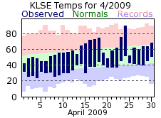
April continued the trend of near normal monthly temperatures but was a bit more consistent day to day compared to the wildly swinging months of February and March. There was one significant aberration as temperatures rocketed to a high of 90 on the 24th ahead of a cold front, then struggled to reach 52 degrees for a high on the 25th behind the front. It was another dry month with measurable precipitation waiting until the 18th of the month to fall. Enhancing the dryness of the month was that nearly 90% of what did fall came on 2 days (the 25th and 26th) with only around one-third of an inch falling outside of that time. The last snow flurry of the 2008-09 winter flew on the 5th.
|
 |
| |
|
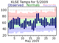
| May was below normal for temperatures, with more days with highs in the 50s (4) compared to the 80s (2). The 17th even flirted with the freezing mark as lows that morning bottomed out at 35 degrees. Precipitation was above normal for May, the first month of 2009 to do this. The rainfall was also fairly spread out, with 7 days recording at least a tenth of an inch or greater. The wettest period was on the 26th and 27th when a combined 2.09 inches fell. |
 |
| |
|
|
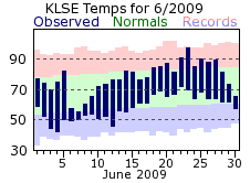
June got the summer months off to a cool start with near or below normal temperatures for the first 17 days. It was particularly chilly on the 6th and 7th when high temperatures failed to reach 60 degrees. Summer warmth returned toward the end of the month with the warmest temperature of the year, 97, occurring on the 23rd. June brought a return to below normal precipitation, although what did fall was spread throughout the month. Out of the 11 days were measurable rainfall was recorded, 6 of those recorded one-quarter inch or greater.
|
 |
| |
|
|
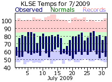
July continued the cool trend of the summer as temperatures were at or below the monthly normal every day. There was no exceedingly cool stretch, just a long, prolonged period where temperatures were more reminiscent of late spring rather than midsummer. Highs never reached or exceeded 90 degrees, which normally occurs about 7 times in a typical July. In the end, it was the 3rd coldest July on record. Precipitation was also lacking compared to a normal July, but like May and June, the rain was distributed across the month. However, there was about a 2 week stretch at mid month where only a couple hundredths of an inch fell.
|
 |
| |
|
|
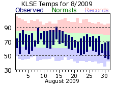
August stayed cool, but was a bit warmer than the other summer months. Still, temperatures only cracked 90 once, leaving the summer total of 4 well below the normal of 15. In fact, the average summer temperature of 68.3 degrees made it the 15th coldest on record for La Crosse. August precipitation was a bit above normal, but one day accounted for nearly 50% of the total (2.55 inches on the 8th).
|
 |
| |
|
|
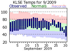
September might be remembered as the most pleasant month of 2009 as a nearly month long spate of dry, clear, and mild conditions reigned. The dry conditions were definitely the highlight though, as rain did not fall until the 21st of the month. This was the driest start to any September on record for La Crosse, and the string of 22 days without even a trace of rainfall (August 30th-September 20th) was the 2nd longest streak of its kind. The 1.02 inch total for the month also made it the 10th driest September on record. The dry weather was a result of persistent high pressure, which also led to many sunny days with light winds. There were 20 days where the sky conditions were considered clear, well above the average of 9 days in a typical September. Also, the wind speed for the month averaged 5 mph, which made it the 2nd least windy month on record for La Crosse, only beat out by February 1974 (4.8 mph). As for temperatures, above normal readings were recorded on 22 of the 30 days. There were no significant warm-ups; rather nearly every day was a few degrees above the monthly normal. The only period which could be considered considerably cooler than normal was the last couple days of the month. The morning low temperatures on the 30th even flirted with freezing, falling to 34 degrees.
|
 |
| |
|
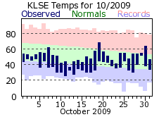
| Flipping the calendar from September to October brought quite a change in the weather for the region, exchanging the mild and dry conditions for unseasonably cool and wet ones. The average temperature of 44.5 degrees made this October the 4th coldest on record for La Crosse while the 5.67 inch precipitation total also made it the 4th wettest. Temperatures were below normal on 25 of the 31 days with the coldest stretch coming around mid-month. From the 10th through the 17th, high temperatures were at or below 50 degrees, with a very chilly high of 37 on the 12th. Lows were near or below freezing. These temperatures were more reflective of a typical November rather than October. Precipitation was plentiful with measurable rain falling on 17 days. The normal is only 8. Over a quarter inch was recorded on 7 of those days. The first measurable snowfall came on the 12th when 0.4 inches fell. |
 |
| |
|
|
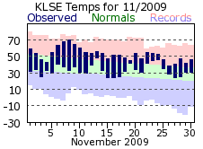
While October seemed more like November when it came to temperatures, November returned the favor by feeling more like October. November temperatures were above normal on every day but two. The monthly average of 42.7 degrees also made it the 4th warmest November on record. Mother Nature’s faucet shutoff in November as measurable precipitation fell on only 5 days. Additionally, what did fall came mostly on one day, with the 0.39 inches on the 25th accounting for 2/3rds of November’s total. Snow only fell twice in November, but in the form of flurries, so there was no measurable snowfall. This trace of snowfall tied it with many other years for the 2nd least snowy November on record for La Crosse.
|
 |
| |
|
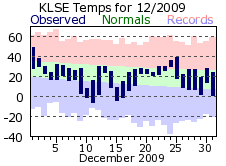
| While November hinted that perhaps winter would start out mild and dry, Mother Nature quickly brought an end to those thoughts in December. A major winter storm struck the region on the 7th through the 9th with over a foot of snow common along with blizzard to near blizzard conditions at times. At La Crosse, 17 inches of snow fell on the 8th and 9th, the 6th highest 2-day amount on record for La Crosse. Snowfall records were also set for both days. Another winter storm would then move across the region just before the Christmas holiday. However, warmer air accompanied this storm, and as a result the precipitation was more mixed: rain, snow, freezing rain and sleet. Snow accumulations were much less as a result, but some icy conditions did develop from time to time, and the winter storm made for some hazardous travel near the holiday. Overall, the 24.9 inch snow total made this the 6th snowiest December on record. The liquid equivalent total of 3.36 inches also made it the 2nd wettest December. Temperatures were a bit colder than normal for December but most of this cold came in the days after each of the winter storms. Otherwise, temperatures were around or a bit above the December normals. |
 |
| |
|
|
Overall, 2009 will be remembered for its very cool summer, an interesting fall where months seemed to reverse themselves, and the winter storms of December bringing record snowfall and other wintery precipitation to the region.
|
 |