Kenneth R. Cook*, Raúl E. López, Ronald L. Holle, and Dan A Baumgardt
NOAA/National Weather Service
Weather in the Upper Mississippi River Valley can be quite volatile during each season. Contributing to this volatility are thunderstorms, which become more frequent during the summer season. During this season, thunderstorm development results primarily from instability aided by diurnal heating or the Mesoscale Convective Systems (MCSs), commonly found in the central United States. The purpose of this study is to surmise the temporal and spatial distribution of cloud-to-ground (CG) lightning strikes in the Upper Mississippi River Valley region and provide possible explanations for the results.
The National Lightning Detection Network (NLDN), now operated by Global Atmospherics Inc. (GAI), has evolved into today's network from three smaller networks. These three, the Bureau and Land Management (BLM) network in the western United States, the National Severe Storms Laboratory (NSSL) network in the Midwest, and the State University of New York at Albany (SUNYA) network on the East Coast, began back in the 1970s and 1980s (Wacker et al., 1999). In 1987, they were integrated into the NLDN and used wideband direction finding (DF) technology. In 1992, the existing NLDN absorbed the time-of-arrival (TOA) sensors contained in a national lightning network, established previously by Atmospheric Research Systems (ARS), resulting in the combination of the two sensing technologies (Wacker et al., 1999). The most recent upgrade, completed in 1995, reduced the total number of sensors from 130 to 106 because of an increase in the effective range of these sensors (Cummins et. al., 1998). The system now contains 47 IMPACT (Improved Performance through Combined Technology) standard sensors, which combine the DF and TOA technology, and 59 LPATS (Lightning Positioning and Tracking System) sensors (Wacker et al., 1999).
Progress in detecting CG lightning strikes has been well documented. A recent publication by Cummins et. al. (1998) of GAI, summarizes the detection efficiency of the network from its past to its current form. Prior to 1992, GeoMet Data Services (GDS), the organization maintaining the network during that time, estimated that the average location accuracy varied from 8 to 16 km in the NLDN. The flash detection efficiency during this same period was around 70%, using first stroke peak currents of greater than 5 kA. In early 1992, GDS calibrated the sensors, increasing the accuracy of the network to 4 to 8 km, with a flash detection efficiency of 65 to 80%. Once the upgrade in 1995 was complete, the location accuracy improved to 1 to 2 km, with a first stroke detection efficiency of 80 to 90% (Cummins et. al., 1998).
Data were gathered from the NLDN for the period January 1989 to September 1998. Gridded arrays of flash density were made for an area extending from northwest Minnesota, southeast to northern Illinois (Figure 1). The dimensions of the flat-earth grid were 920 X 1020 km with 10 km resolution. The grids were created on a monthly basis for positive and total CG flashes. Additionally, hourly time series of CG flashes, both positive and total, were developed for each month and plotted. It should be noted that June and July of 1991 were omitted from this study as the data were not complete. Moreover, data along the extreme northern portion of the domain was not considered in this study, as it is along the fringe of the NLDN, and is therefore subject to errors.
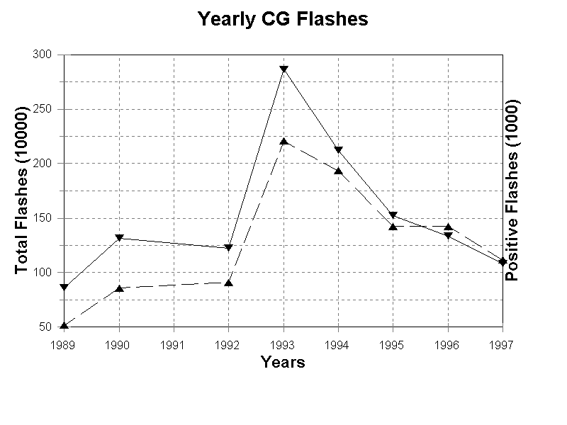
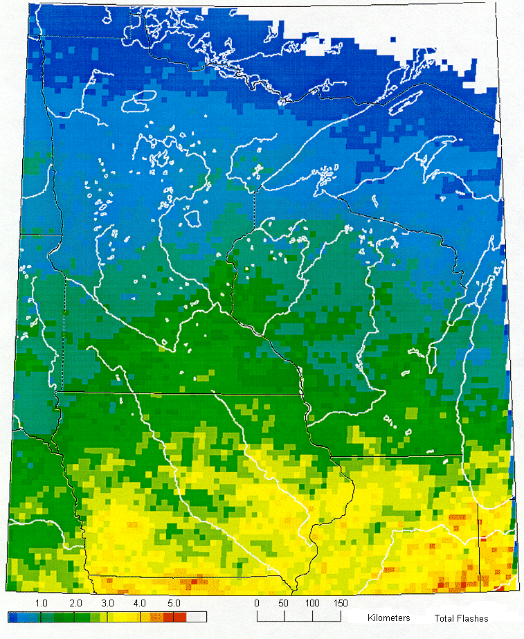
Figure 2 shows the yearly flash counts of total CG strikes found for the years 1989, 1990, and 1992 through 1997. The average number of CG lightning strikes per year was over 1.5 million. Quite notable is the large number, nearly twice the average, of CG flashes which occurred during 1993, the year of the unprecedented flooding along the Mississippi River. The maximum density of CG flashes was 5.7 flashes per km2 per year. In general, flash density decreased from south to north, with a maximum in CG flash densities observed across southern Iowa, northern Missouri, and northern Illinois (Figure 3). This distribution shows the influence that latitude may have on the domain. The average monthly distribution of CG flashes (Figure 4) showed that the majority of CG lightning strikes occurred in the summer months of June, July, and August with a minimum during the winter months of December, January, and February. The summer influence was so great that the result from the other seasons was rather insignificant for this climatological study, a consequence of the domain's northern latitude.
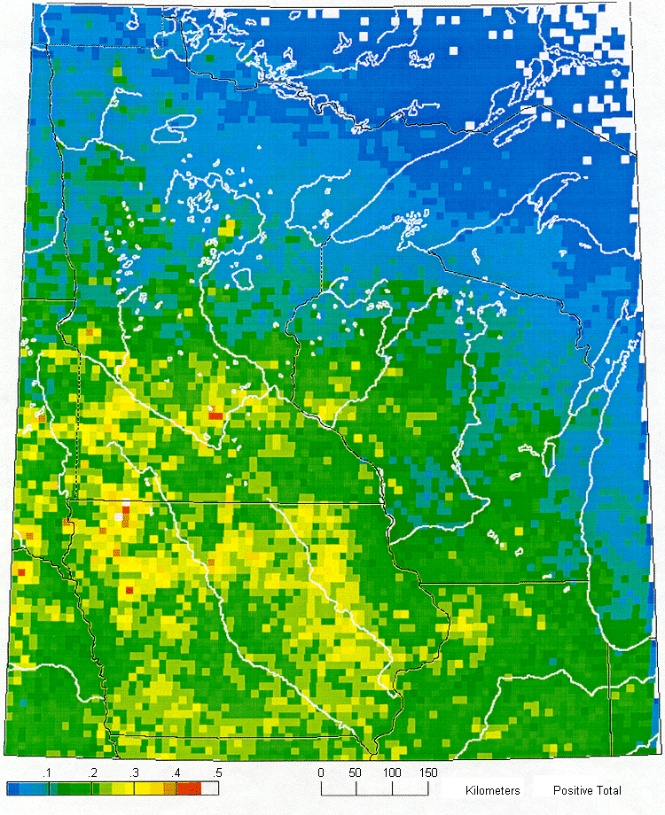
The distribution of positive flashes (Figure 5) showed different results with a maximum of 0.5 CG flashes per km2 per year over southwest Minnesota and northwest Iowa. In general, high positive CG flash densities were observed over southern Minnesota, extreme eastern South Dakota and Nebraska, northern Missouri and Iowa. The positive flash density generally decreased from the southwest maximum, to a northern and eastern minimum, which extended from northern Minnesota, southeast across northern and eastern Wisconsin.
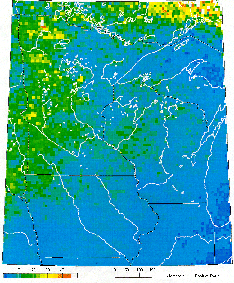
A plot was made of the ratio of positive polarity CG flashes to total of all CG flashes (Figure 6). The result of this depicted a percentage maximum which extended along the western edge of Minnesota. Between 25 and 33% of all CG flashes in this area were of the positive polarity. A percent positive polarity minimum was observed along the southern tier of the domain, across southern Iowa and northern Missouri and extended east through northern Illinois. The observation of higher ratios in the upper Midwest is not new and has been previously discussed by Orville (1994) as having two possible explanations.
Firstly, Rutledge and MacGorman (1988) found the occurrence of positive flashes in the stratiform precipitation associated with MCSs, which are common east of the Rocky Mountains. The area of positive polarity found in this study's domain coincides with Orville's (1994) observation. A second explanation may be offered as percent positive being a function of temperature. Dong and Hallett (1992) found that the charge separation process is a function of temperature. With increasing latitude, the height of the melting layer is reduced, thus reducing the distance between the net charge regions. This may cause an increase in overall positive CG flashes and therefore an increase in percent positive CG flashes. Actual observations of percent positive CG flashes as a function of month have been made by Orville and Silver (1997). From this, a maximum in percent positive occurred during the winter and a minimum during the summer, which can arguably be a function of temperature as well. These may provide an explanation for the decrease from northwest to southeast of percent positive polarity, across this study's domain, which corresponds to a climatological increase in yearly normal temperatures.
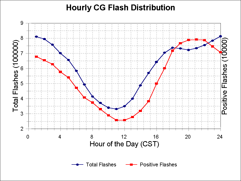
The total hourly distribution of CG lightning strikes (Figure 7) indicated two maxima. The first occurred during the evening, between 6 and 7 p.m. CST and the second between midnight and 1 a.m CST. This second maximum was nearly 10% greater than the first. Monthly analysis of the data revealed the nocturnal maximum increased as the summer season neared, becoming the more dominant in June. This continued through September, with its time of occurrence varying 4 hours (Figure 7). This maximum in nocturnal thunderstorm activity has been previously observed by Rasmusson (1971) and is a result of the MCS activity which commonly affects the region. The first maximum, however, is much different and is likely from thunderstorms associated with diurnal heating. One minimum of CG strikes was found which occurred between 11 a.m. and noon. Analysis of the hourly distribution of positive CG flashes indicated only one maximum (Figure 9). This occurred between 9 and 10 p.m. CST, which was coincidentally in between the times of the two total flash maxima described above.
This study examined CG lightning strike data from the NLDN during the period from 1989 to 1998. Documented were variations in space and time of CG lightning strikes for the Upper Mississippi River Valley region. Positive polarity CG strikes were calculated in addition to the total CG strikes. Over 12 million CG strikes were processed during this period.
The highest density of total CG strikes was observed across the southern tier of the domain, including southern Iowa, northern Illinois, and northern Missouri. This density decreased from south to north, an indication of a strong latitudinal influence. Analysis of positive polarity CG strikes showed a different result, with the maximum occurring across the southwestern portion of the domain, namely southwest Minnesota. A minimum extended from northern Minnesota, southeast into eastern Wisconsin. A maximum of percent positive CG strikes was observed along the western edge of Minnesota, which decreased to a minimum extending from northern Illinois into Iowa. The distribution of positive CG strikes and percent positive may be attributed to two mechanisms, latitudinal influences and MCS activity commonly found in this region.
Hourly distribution of total CG lightning strikes varied throughout the year with two pronounced maxima during the summer months. The first maximum occurred from 6 to 7 p.m. CST and the second between 12 and 1 a.m. CST. These two maxima are likely a result of thunderstorms associated with diurnal heating (the first maximum) and MCS activity (second maximum). A diurnal minimum in CG lightning strikes was also observed from 11 a.m. to noon. Only one maximum was found in the hourly distribution of positive CG strikes, between 9 and 10 p.m. CST.
Cummins, K. L., M. J. Murphy, E. A. Bardo, W. L. Hiscox, R. B. Pyle, and A. E. Pifer, 1998: A combined
TOA/MDF technology upgrade of the U. S. National Lightning Detection Network. J. Geophys. Res., 103,
D8, 9035-9044.
Dong, Y. and J. Hallett, 1992: Charge seperation by ice and water drops during growth and evaporation. J.
Geophys. Res., 97, D18, 20,361-13,212.
Orville, R. E., 1994: Cloud-to-ground lightning flash characteristics in the contigious United States: 1989-1991.
J. Geophs. Res., 99, D5, 10,833- 10,841.
Orville, R. E. and A. C. Silver, 1997: Lightning ground flash density in the contigious United States: 1992-1995.
Mon. Wea. Rev., 125, 4, 631-638.
Rasmusson, E. M., 1971: Diurnal variation of summertime thunderstorm activity over the United States.
USAFTAC, TN 71-4, 1-12.
Rutledge, S. A. and D. R. MacGorman, 1988: Cloud-to- ground lightning activity in the 10-11 June 1985
mesoscale convective system observed during the Oklahoma-Kansas PRE-STORM project. Mon. Wea.
Rev., 116, 1393-1408.
Wacker, R. S., and R. E. Orville, 1999: Changes in measured lightning flash count and return stroke peak
current after the 1994 U. S. National Lightning Detection Network upgrade. J. Geophys. Res., 104, D2,
2151-2157, 1999.


 Weather Story
 Weather Map
 Local Radar