Overview
|
A winter weather system produced widespread snow accumulations from the afternoon of March 9th into the early morning hours of Friday, March 10th. The heaviest snow fell from extreme eastern Minnesota into western and central Wisconsin, including numerous reports of 6-8 inches of new snow. The precipitation was mainly snow but during the afternoon of Thursday, March 9th, most of the snow melted as it fell, especially on roads. As temperatures cooled late in the day, accumulations increased which impacted travel all the way into the morning of the 10th. |
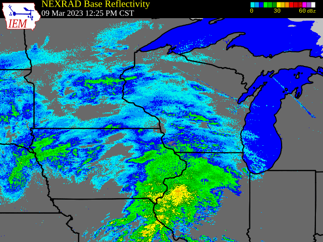 Radar loop March 9-10 |
Snow
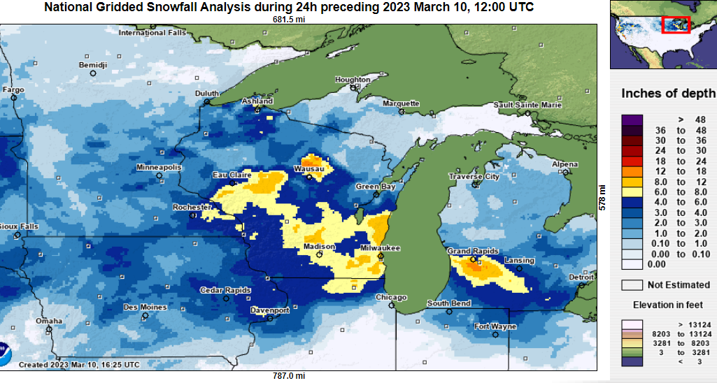
PUBLIC INFORMATION STATEMENT
NATIONAL WEATHER SERVICE LA CROSSE WI
1255 PM CST FRI MAR 10 2023

...SNOWFALL REPORTS FROM MARCH 9-10...

LOCATION                     AMOUNT    TIME/DATE       LAT/LON

...IOWA...

...ALLAMAKEE COUNTY...
HARPERS FERRY 6.4 SSW        4.8 IN    0700 AM 03/10   43.11N/91.20W
POSTVILLE 5.5 NE             3.8 IN    0700 AM 03/10   43.14N/91.49W
MONONA 9.8 N                 2.0 IN    0700 AM 03/10   43.19N/91.35W

...CHICKASAW COUNTY...
NEW HAMPTON                  2.2 IN    0700 AM 03/10   43.06N/92.32W
NEW HAMPTON 0.4 SW           2.0 IN    0700 AM 03/10   43.06N/92.32W

...CLAYTON COUNTY...
4 SW GARNAVILLO              5.0 IN    0836 AM 03/10   42.82N/91.29W
STRAWBERRY POINT             4.4 IN    0700 AM 03/10   42.69N/91.53W
ELKADER                      2.5 IN    0838 AM 03/10   42.86N/91.40W

...FAYETTE COUNTY...
WAUCOMA 1 WNW                3.0 IN    0700 AM 03/10   43.06N/92.05W
FAYETTE                      2.5 IN    0700 AM 03/10   42.88N/91.83W

...FLOYD COUNTY...
CHARLES CITY                 3.4 IN    0700 AM 03/10   43.06N/92.67W
NORA SPRINGS 2.4 SSE         2.5 IN    0700 AM 03/10   43.11N/92.99W
MARBLE ROCK                  2.0 IN    0753 AM 03/10   42.97N/92.87W

...HOWARD COUNTY...
ELMA                         3.2 IN    0700 AM 03/10   43.24N/92.44W

...MITCHELL COUNTY...
OSAGE                        3.0 IN    0809 AM 03/10   43.28N/92.81W

...WINNESHIEK COUNTY...
4 NW DECORAH                 4.8 IN    0845 AM 03/10   43.34N/91.84W
7 ENE DECORAH                4.7 IN    0823 AM 03/10   43.34N/91.64W
CALMAR                       2.0 IN    0700 AM 03/10   43.19N/91.86W

...MINNESOTA...

...FILLMORE COUNTY...
CHATFIELD                    5.0 IN    0756 AM 03/10   43.85N/92.19W
CHATFIELD 9.0 ESE            5.0 IN    0700 AM 03/10   43.79N/92.03W
WYKOFF 3.1 NW                4.3 IN    0700 AM 03/10   43.74N/92.31W
MABEL                        3.5 IN    0700 AM 03/10   43.52N/91.76W
SPRING VALLEY                3.0 IN    0700 AM 03/10   43.69N/92.39W

...HOUSTON COUNTY...
HOKAH 4 NW                   6.6 IN    0700 AM 03/10   43.80N/91.43W
1 ENE MOUND PRAIRIE          6.6 IN    0700 AM 03/10   43.79N/91.42W
SPRING GROVE                 6.0 IN    0812 AM 03/10   43.56N/91.64W
CALEDONIA 5.4 S              6.0 IN    0800 AM 03/10   43.56N/91.51W
HOUSTON 6.9 E                5.1 IN    0845 AM 03/10   43.76N/91.43W
1 NE MOUND PRAIRIE           5.0 IN    0813 AM 03/10   43.79N/91.44W
LA CRESCENT 5.4 SW           5.0 IN    0700 AM 03/10   43.78N/91.39W
CALEDONIA                    5.0 IN    0649 AM 03/10   43.63N/91.50W

...MOWER COUNTY...
WALTHAM 2.0 SE               5.5 IN    0800 AM 03/10   43.80N/92.85W
4 WSW AUSTIN                 4.5 IN    0739 AM 03/10   43.64N/93.05W

...OLMSTED COUNTY...
5 SW ELBA                    6.5 IN    0949 AM 03/10   44.05N/92.09W
ROCHESTER 5.7 N              5.6 IN    0715 AM 03/10   44.10N/92.46W
2 SSE ROCHESTER              5.5 IN    0803 AM 03/10   43.99N/92.47W
2 NNW ROCHESTER              5.0 IN    0759 AM 03/10   44.04N/92.49W
ELGIN 2SSW                   5.0 IN    0700 AM 03/10   44.10N/92.27W
BYRON                        4.5 IN    0807 AM 03/10   44.03N/92.65W
ROCHESTER INTL AIRPORT       3.6 IN    1200 PM 03/10
4 ESE DOUGLAS                3.5 IN    0721 AM 03/10   44.08N/92.51W
ROCHESTER 4.7 N              3.1 IN    0700 AM 03/10   44.08N/92.48W
ELBA 4.7 SW                  1.8 IN    0800 AM 03/10   44.04N/92.09W

...WABASHA COUNTY...
THEILMAN 1 SSW               5.7 IN    0730 AM 03/10   44.28N/92.19W
1 W READS LANDING            5.5 IN    0858 AM 03/10   44.40N/92.10W
WABASHA 6.2 WNW              5.5 IN    0700 AM 03/10   44.39N/92.16W
KELLOGG 0.1 N                4.5 IN    0800 AM 03/10   44.31N/92.00W
2 W WABASHA                  4.5 IN    0750 AM 03/10   44.38N/92.09W
LAKE CITY                    4.0 IN    0843 AM 03/10   44.45N/92.27W
KELLOGG                      4.0 IN    0801 AM 03/10   44.31N/92.00W
ZUMBRO FALLS 3.5 SSW         3.9 IN    0700 AM 03/10   44.24N/92.46W

...WINONA COUNTY...
2 NNW WILSON                 6.0 IN    0856 AM 03/10   43.98N/91.71W
LA CRESCENT DAM 7            6.0 IN    0800 AM 03/10   43.87N/91.31W
WINONA 2.0 ESE               6.0 IN    0710 AM 03/10   44.04N/91.63W
WINONA 1.9 ESE               5.5 IN    0805 AM 03/10   44.04N/91.63W
2 N MONEY CREEK              4.8 IN    0824 AM 03/10   43.85N/91.62W

...WISCONSIN...

...ADAMS COUNTY...
6 E BIG FLATS                7.5 IN    0753 AM 03/10   44.11N/89.69W
OXFORD 4.3 W                 7.2 IN    0800 AM 03/10   43.79N/89.65W
NEKOOSA 8.0 SSE              7.0 IN    0700 AM 03/10   44.21N/89.85W
OXFORD 4.0 W                 6.5 IN    0700 AM 03/10   43.79N/89.64W
9 ENE FRIENDSHIP             6.0 IN    0837 AM 03/10   44.01N/89.66W
0.6 W FRIENDSHIP             5.6 IN    0700 AM 03/10   43.98N/89.83W

...BUFFALO COUNTY...
COCHRANE                     5.9 IN    0830 AM 03/10   44.22N/91.84W
1 W MARSHLAND                5.0 IN    0756 AM 03/10   44.08N/91.58W

...CLARK COUNTY...
2 NW LAKE ARBUTUS            8.0 IN    0751 AM 03/10   44.45N/90.73W
5 W RIPLINGER                6.8 IN    0840 AM 03/10   44.82N/90.50W
6 N CHILI                    6.5 IN    0854 AM 03/10   44.71N/90.34W
6 ENE LAKE ARBUTUS           6.0 IN    0845 AM 03/10   44.46N/90.59W
OWEN 1E                      5.0 IN    0700 AM 03/10   44.95N/90.55W

...CRAWFORD COUNTY...
MOUNT ZION                   6.0 IN    0826 AM 03/10   43.26N/90.73W
3 NE BELL CENTER             6.0 IN    0803 AM 03/10   43.32N/90.77W
GAYS MILLS 1.0 NE            6.0 IN    0700 AM 03/10   43.33N/90.84W
STEUBEN 4SE                  5.5 IN    0700 AM 03/10   43.13N/90.84W
EASTMAN                      4.5 IN    0825 AM 03/10   43.16N/91.02W
3 SW SOLDIERS GROVE          4.5 IN    0757 AM 03/10   43.36N/90.81W
2.8 E HARPERS FERRY          4.0 IN    0800 AM 03/10   43.21N/91.10W
0.6 NE PRAIRIE DU CHIEN      4.0 IN    0700 AM 03/10   43.05N/91.13W

...GRANT COUNTY...
2 SE BLUE RIVER              8.0 IN    0915 AM 03/10   43.17N/90.55W
MUSCODA                      8.0 IN    0825 AM 03/10   43.19N/90.44W
MUSCODA 0.5 WSW              6.8 IN    0830 AM 03/10   43.18N/90.44W
STITZER                      5.5 IN    0806 AM 03/10   42.93N/90.62W
3 WNW PLATTEVILLE            5.2 IN    0802 AM 03/10   42.75N/90.54W
3 NE MOUNT HOPE              5.0 IN    0802 AM 03/10   43.00N/90.82W
BAGLEY                       5.0 IN    0800 AM 03/10   42.90N/91.10W
BOSCOBEL                     5.0 IN    0718 AM 03/10   43.14N/90.71W
CASSVILLE 7.8 ENE            4.5 IN    0700 AM 03/10   42.75N/90.84W
PATCH GROVE 0.1 NNW          4.0 IN    0700 AM 03/10   42.94N/90.97W
4.3 W LANCASTER              3.5 IN    0800 AM 03/10   42.83N/90.79W

...JACKSON COUNTY...
2 S BLACK RIVER FALLS        7.2 IN    0831 AM 03/10   44.27N/90.84W
4 NE DISCO                   6.5 IN    0752 AM 03/10   44.30N/90.95W
3 ENE NORTH BEND             5.8 IN    0806 AM 03/10   44.11N/91.06W
MELROSE 3.6 W                5.8 IN    0700 AM 03/10   44.13N/91.07W

...JUNEAU COUNTY...
LYNDON STATION               8.0 IN    0841 AM 03/10   43.71N/89.90W
1.0 E MAUSTON                7.5 IN    0800 AM 03/10   43.79N/90.06W
5 SSE PLAINVILLE             7.0 IN    0751 AM 03/10   43.65N/89.79W
WONEWOC                      6.0 IN    0842 AM 03/10   43.65N/90.22W
1 SSE HUSTLER                5.0 IN    0754 AM 03/10   43.86N/90.26W

...LA CROSSE COUNTY...
LA CROSSE NWS                6.3 IN    1200 PM 03/10
MINDORO                      6.0 IN    1022 AM 03/10   44.02N/91.10W
4 SSE LA CROSSE              6.0 IN    0835 AM 03/10   43.77N/91.21W
LA CROSSE REGIONAL AIRPORT   5.7 IN    1200 PM 03/10
LA CROSSE 4NNW               5.5 IN    0730 AM 03/10   43.87N/91.27W
ONALASKA 1.9 E               5.5 IN    0700 AM 03/10   43.89N/91.18W
COON VALLEY 4.5 NNW          5.1 IN    0700 AM 03/10   43.76N/91.06W
ONALASKA                     5.0 IN    0801 AM 03/10   43.88N/91.22W
2 SSE HOLMEN                 5.0 IN    0712 AM 03/10   43.94N/91.24W

...MONROE COUNTY...
WARRENS 4.7 WSW              8.1 IN    0700 AM 03/10   44.10N/90.59W
3 NNE TUNNEL CITY            5.5 IN    0859 AM 03/10   44.04N/90.55W
CATARACT                     5.5 IN    0839 AM 03/10   44.09N/90.84W
1 S TOMAH                    5.5 IN    0803 AM 03/10   43.98N/90.51W
5 WSW MILLSTON               5.3 IN    1026 AM 03/10   44.16N/90.74W
4 SW FORT MC COY             4.2 IN    0840 AM 03/10   43.98N/90.74W
0.5 SW SPARTA                4.0 IN    0900 AM 03/10   43.94N/90.82W
TOMAH 7.5 SSW                4.0 IN    0700 AM 03/10   43.90N/90.58W
CASHTON 3 NNW                3.4 IN    0745 AM 03/10   43.79N/90.80W

...RICHLAND COUNTY...
ROCKBRIDGE                   7.5 IN    0841 AM 03/10   43.45N/90.36W
2 SSE SEXTONVILLE            7.5 IN    0755 AM 03/10   43.26N/90.27W
2 E YUBA                     6.0 IN    1025 AM 03/10   43.54N/90.39W
BOAZ                         6.0 IN    0835 AM 03/10   43.33N/90.53W
RICHLAND CENTER 4 N          4.0 IN    0700 AM 03/10   43.40N/90.39W

...TAYLOR COUNTY...
MEDFORD 0.8 ENE              6.3 IN    0700 AM 03/10   45.14N/90.33W
2 N DORCHESTER               4.5 IN    0832 AM 03/10   45.04N/90.34W

...TREMPEALEAU COUNTY...
ARCADIA                      7.0 IN    0705 AM 03/10   44.25N/91.49W
ETTRICK 4.0 WNW              6.8 IN    0655 AM 03/10   44.19N/91.34W
DODGE                        5.5 IN    0844 AM 03/10   44.13N/91.55W
ETTRICK                      5.0 IN    1007 AM 03/10   44.17N/91.27W
1 NE GALESVILLE              4.0 IN    0837 AM 03/10   44.10N/91.34W

...VERNON COUNTY...
0.5 E VIROQUA                6.4 IN    0700 AM 03/10   43.56N/90.88W
3 SSE GENOA                  6.3 IN    0806 AM 03/10   43.53N/91.21W
LA FARGE                     6.2 IN    0700 AM 03/10   43.57N/90.63W
2 E LA FARGE                 6.0 IN    0826 AM 03/10   43.58N/90.60W
2 NE STODDARD                5.9 IN    0802 AM 03/10   43.68N/91.19W
STODDARD 1.5 NE              5.9 IN    0730 AM 03/10   43.67N/91.19W
HILLSBORO 2 SW               5.6 IN    0700 AM 03/10   43.63N/90.38W
VIROQUA 0.8 ESE              5.0 IN    0700 AM 03/10   43.55N/90.87W

OBSERVATIONS ARE COLLECTED FROM A VARIETY OF SOURCES WITH VARYING
EQUIPMENT AND EXPOSURES. WE THANK ALL VOLUNTEER WEATHER OBSERVERS
FOR THEIR DEDICATION. NOT ALL DATA LISTED ARE CONSIDERED OFFICIAL.
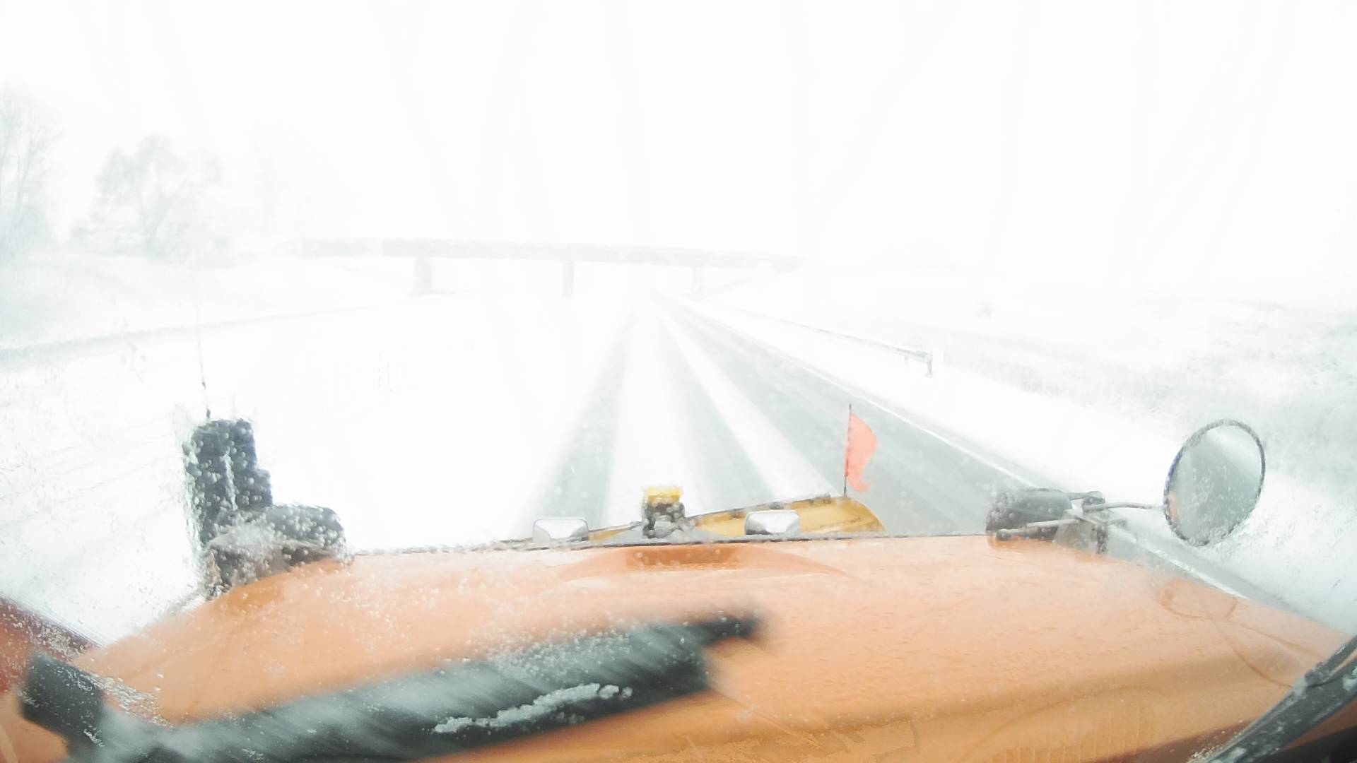
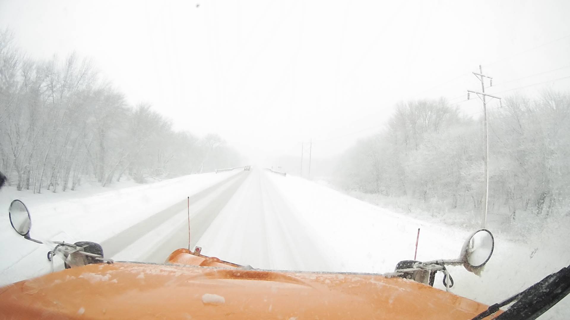
Photos:
 |
 |
||
| Snow Plow camera view as snow moved in. (Courtesy of IADOT) |
Snow Plow camera view as snow moved in. (Courtesy of IADOT) |
Caption (source) |
Caption (source) |
Graphics / Information
 |
 |
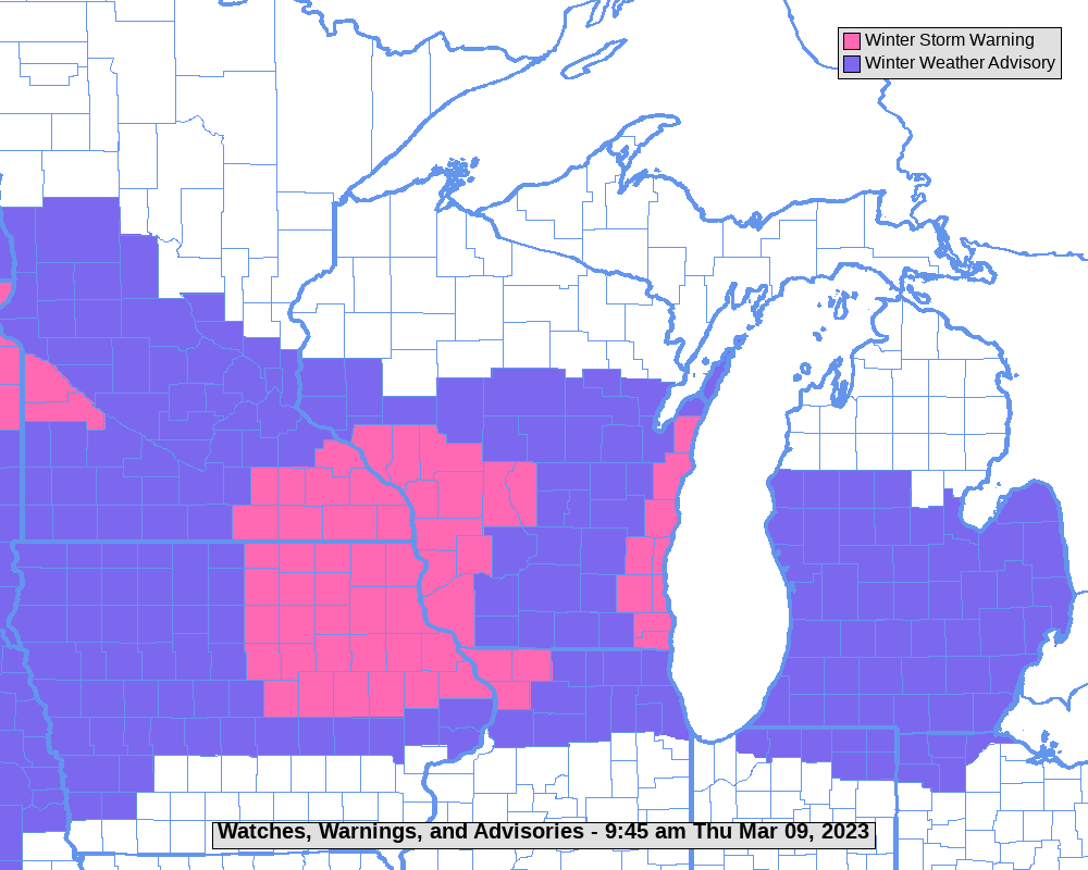 |
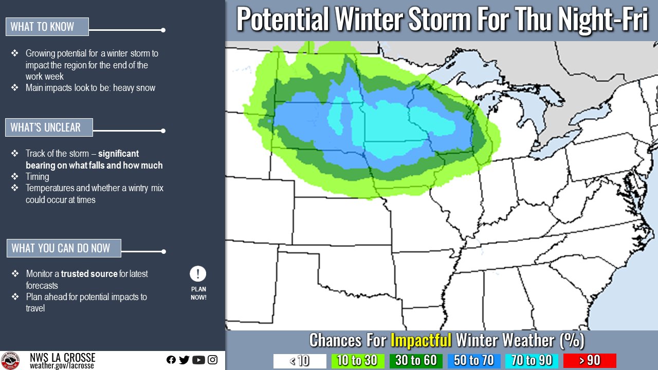
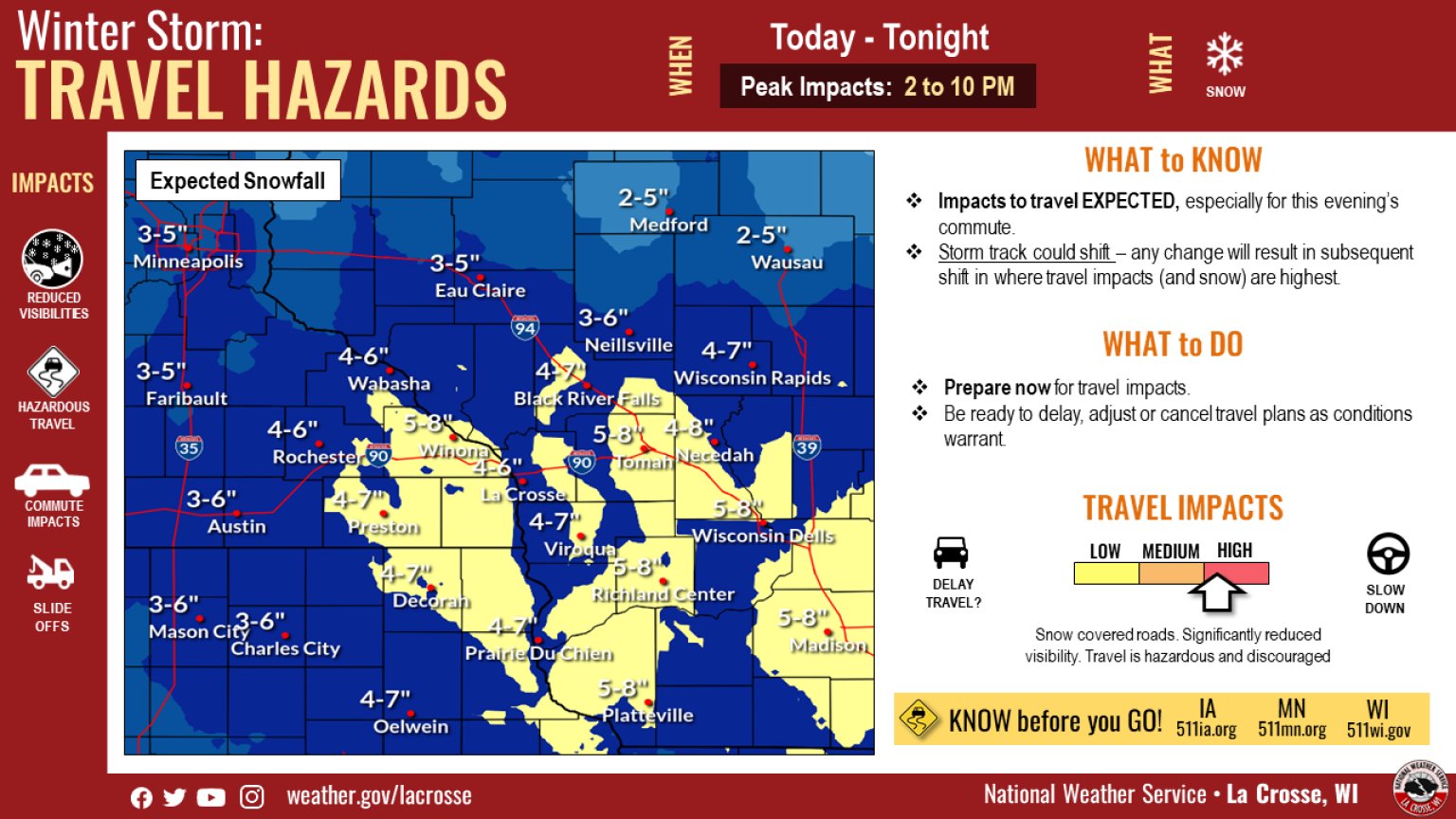
| Figure 1: Graphic issued days in advance of potential for heavy snow and/or a winter storm | Figure 2: Safety and informational graphic with updated snow forecast | Figure 3: Warning & Advisory map |
| Figure 4: Caption | Figure 5: Caption | Figure 6: Caption |
 |
Media use of NWS Web News Stories is encouraged! Please acknowledge the NWS as the source of any news information accessed from this site. |
|


 Weather Story
 Weather Map
 Local Radar