
Tropical Storm Bertha could bring tropical storm conditions to portions of the Florida Panhandle and Alabama coast through Wednesday, where a Tropical Storm Watch and Storm Surge Watch is in effect. Numerous severe thunderstorms with heavy rainfall are expected from the Ohio Valley into the Mid-Atlantic and Northeast Tuesday. Read More >
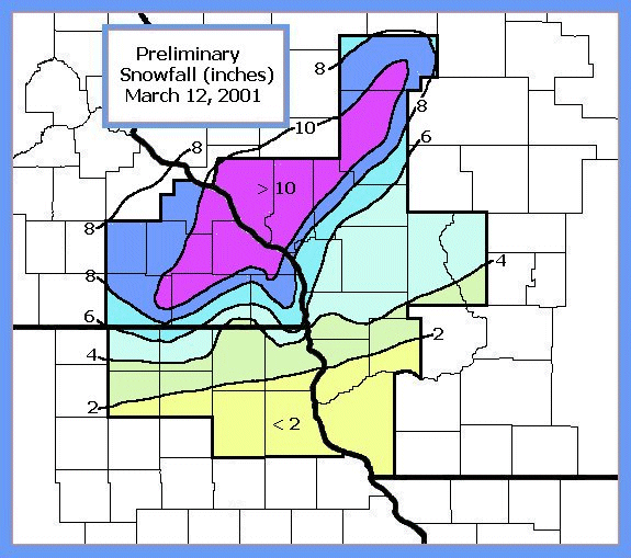
March 12, 2001 Snow Totals
Low pressure developed over northeast Kansas during the evening of the 11th. The low moved into southwest Iowa early Monday morning and as it did, a mixture of precipitation developed across the region. Snow occurred from west central Wisconsin back into north central Iowa. A band of mixed wintry precipitation developed across southwest Wisconsin into central Iowa with rain south of this area. As the low moved into north central Iowa during the morning of the 12th, the bands of precipitation showed very little movement. By the late afternoon of the 12th, the low had moved into northern Wisconsin and had pushed the snow and mixed precipitation north of the region. The stage was set for some locations to receive heavy snow when the bands of precipitation showed very little movement as the low approached the area. A swath of snowfall exceeding 6 inches occurred over all of southeast Minnesota into west central Wisconsin with a band of 10+ inches extending from an area south and east of Rochester to near Medford Wisconsin.
Snow totals for March 12th.
ZCZC MKEPNSLSE
ABUS34 KLSE 122106
PUBLIC INFORMATION STATEMENT
NATIONAL WEATHER SERVICE LA CROSSE WI
300 PM CST MON MAR 12 2001

...SNOW TOTALS AS OF 3 PM...

CITY           COUNTY       STATE  SNOWFALL (INCHES)

SPRING VALLEY  FILLMORE      MN     11.0 INCHES
WINONA 3S      WINONA        MN     10.3 INCHES
STEWARTVILLE   OLMSTED       MN     10.0 INCHES
WABASHA        WABASHA       MN     10.0 INCHES
GOODVIEW       WINONA        MN     10.0 INCHES
LA CRECENT     HOUSTON       MN      9.5 INCHES
ROCHESTER      OLMSTED       MN      8.0 INCHES
KELLOGG 7SW    WABASHA       MN      8.0 INCHES
BYRON          OLMSTED       MN      6.3 INCHES
HIGHLAND       FILLMORE      MN      6.0 INCHES
DODGE CENTER   DODGE         MN      5.5 INCHES
AUSTIN         MOWER         MN      5.0 INCHES

WHITEHALL      TREMPEALEAU   WI     11.0 INCHES
WILLARD        TAYLOR        WI     10.5 INCHES
GILMANTON      BUFFALO       WI     10.0 INCHES
MEDFORD        TAYLOR        WI     10.0 INCHES
TAYLOR         JACKSON       WI      9.5 INCHES
MERRILLAN      JACKSON       WI      9.0 INCHES
MODENA 2S      BUFFALO       WI      8.5 INCHES
LA CROSSE      LA CROSSE     WI      7.5 INCHES
HOLMEN 2S      LA CROSSE     WI      7.4 INCHES
OSSEO          TREMPEALEAU   WI      7.0 INCHES
ONALASKA 1N    LA CROSSE     WI      6.8 INCHES
LSE WEATHER OFFICE  LA CROSSE  WI    6.6 INCHES
WILTON         MONROE        WI      6.0 INCHES
WITHIE         CLARK         WI      5.0 INCHES
FRIENDSHIP     ADAMS         WI      5.0 INCHES
CAMP DOUGLAS   JUNEAU        WI      5.0 INCHES
LA FARGE       VERNON        WI      4.0 INCHES
PLAINVILLE 5N  ADAMS         WI      3.0 INCHES
VIROQUA        VERNON        WI      3.0 INCHES
PRAIRIE DU CHIEN CRAWFORD    WI      1.5 INCHES
RICHLAND CENTER  RICHLAND    WI      1.0 INCH
BLOOMINGTON    GRANT         WI      1.0 INCH


DORCHESTER     ALLAMAKEE     IA      6.0 INCHES
OSAGE          MITCHELL      IA      4.0 INCHES
CRESCO         HOWARD        IA      4.0 INCHES
FLOYD          FLOYD         IA      2.7 INCHES
CHARLES CITY   FLOYD         IA      2.0 INCHES
NEW HAMPTON    CHICKASAW     IA      2.0 INCHES
OSSIAN         WINNISHIEK    IA      2.0 INCHES
DECORAH        WINNESHIEK    IA      1.5 INCHES
WAUKON         ALLAMAKEE     IA      1.5 INCHES
NEW HAMPTON    CHICKASAW     IA      0.5 INCHES
CLAYTON CENTER CLAYTON       IA      0.5 INCHES


$$

LSE STAFF
NNNN
Additional totals received through our web site:
| Location | County | Snowfall |
| La Crosse | La Crosse | 5.2" |
| Goodview | Winona | 9" |
| Rochester | Olmsted | 8.2" |
| Holmen 2S | La Crosse | 6.7" |
| Floyd | Floyd | 2.75" |
| Onalaska | La Crosse | 9.5" |
| La Farge | Vernon | 4" |
| Austin | Mower | 5" |
| Melrose 4N | Jackson | 5" |


 Weather Story
 Weather Map
 Local Radar