Overview
|
A passing weather system brought a swath of snow from the Dakotas into the western Great Lakes on Sunday evening March 12th into the morning hours of Monday March 13th. Snow accumulations ranged from 1 to 2 inches over north-central Wisconsin to as much as 6 to 10 across portions of northeast Iowa and southeast Minnesota. Very little wind was noted with this storm. |
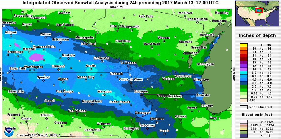 24-hr Snowfall amounts ending 7a.m. March 13, 2017 |
Snowfall Amounts:
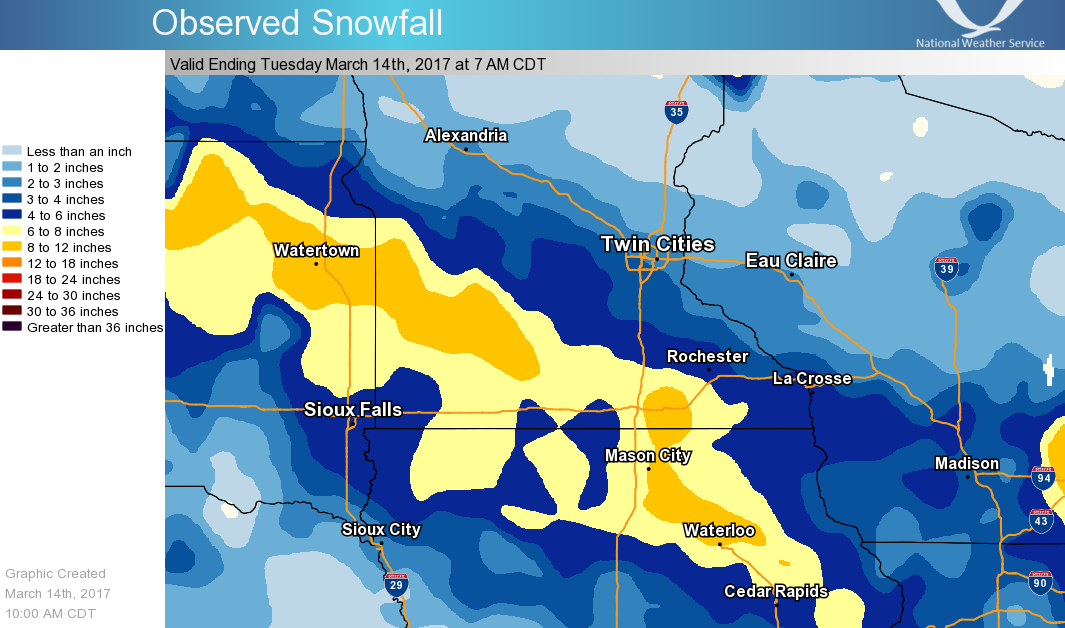
24 hour snowfall plot (through 7 am Mar 13)
Public Information Statement
National Weather Service La Crosse WI
134 PM CDT Mon Mar 13 2017

...Snowfall Reports...

Location                     Amount    Time/Date       Lat/Lon

...Iowa...

...Allamakee County...
Waukon 2E                    6.5 in    0730 AM 03/13
Waukon                       6.0 in    0209 AM 03/13   43.27N/91.48W
6 NNW Waukon                 6.0 in    1100 AM 03/13   43.35N/91.52W
Harpers Ferry                4.5 in    0647 AM 03/13   43.20N/91.15W

...Chickasaw County...
New Hampton                  10.0 in   0700 AM 03/13   43.06N/92.31W
Ionia 2W                     8.0 in    0700 AM 03/13   43.03N/92.50W

...Clayton County...
Edgewood                     4.0 in    0506 AM 03/13   42.64N/91.40W
Marquette                    4.0 in    0800 AM 03/13   43.05N/91.18W
Monona WWTP                  3.8 in    0700 AM 03/13   43.04N/91.40W
Elkader                      3.5 in    0206 AM 03/13   42.86N/91.40W
Guttenberg                   3.0 in    0459 AM 03/13   42.79N/91.10W
Guttenberg Dam 10            2.0 in    0600 AM 03/13   42.78N/91.10W
Clayton Center               1.3 in    0646 AM 03/13   42.89N/91.33W

...Fayette County...
2 NNW Fayette                7.8 in    0630 AM 03/13   42.87N/91.82W
1 WNW Oelwein                7.1 in    0530 AM 03/13   42.68N/91.93W
Oelwein                      7.1 in    0700 AM 03/13   42.68N/91.93W
Fayette                      6.3 in    0700 AM 03/13   42.85N/91.82W
Waucoma 1WNW                 6.0 in    0700 AM 03/13   43.06N/92.05W

...Floyd County...
Nora Springs 2.4 SSE         8.0 in    0700 AM 03/13   43.11N/92.99W
Nashua 2sw                   8.0 in    0700 AM 03/13   42.94N/92.57W
Charles City                 7.8 in    0700 AM 03/13   43.06N/92.67W

...Howard County...
Elma                         5.6 in    0700 AM 03/13   43.24N/92.44W
Cresco 1NE                   5.5 in    0700 AM 03/13   43.39N/92.09W

...Mitchell County...
St Ansgar                    8.2 in    0630 AM 03/13   43.38N/92.92W
Osage                        7.4 in    0700 AM 03/13   43.28N/92.81W

...Winneshiek County...
7 ENE Decorah                5.4 in    0800 AM 03/13   43.34N/91.64W
5 ESE Decorah                5.3 in    0700 AM 03/13   43.26N/91.70W
2 NW Decorah                 5.0 in    0824 AM 03/13   43.33N/91.83W
Decorah                      4.5 in    0205 AM 03/13   43.31N/91.79W
Calmar NE                    3.8 in    0700 AM 03/13   43.19N/91.86W

...Minnesota...

...Dodge County...
Dodge Center                 6.1 in    0700 AM 03/13   44.03N/92.87W
West Concord                 6.0 in    1118 AM 03/13   44.15N/92.90W
2 NE Kasson                  5.5 in    0700 AM 03/13   44.05N/92.72W
Dodge Center                 5.0 in    0747 AM 03/13   44.03N/92.85W

...Fillmore County...
Spring Valley                8.0 in    0400 AM 03/13   43.69N/92.39W
Preston                      7.0 in    0400 AM 03/13   43.67N/92.08W
Lanesboro 2NE                6.1 in    0740 AM 03/13   43.73N/91.94W
1 S Peterson                 6.1 in    0715 AM 03/13   43.77N/91.83W
Lanesboro                    6.0 in    0400 AM 03/13   43.72N/91.97W
Lanesboro 3S                 6.0 in    0900 AM 03/13
1 W Fillmore                 6.0 in    0700 AM 03/13   43.74N/92.31W
1 SSE Pilot Mound            6.0 in    0700 AM 03/13   43.79N/92.03W
1 SSW Cherry Grove           6.0 in    0600 AM 03/13   43.58N/92.30W
Spring Valley 3E             5.5 in    0700 AM 03/13   43.68N/92.33W
Mabel                        4.5 in    0735 AM 03/13   43.52N/91.76W

...Houston County...
Hokah                        6.0 in    0845 AM 03/13   43.76N/91.35W
Hokah 2S                     6.0 in    0700 AM 03/13
Caledonia                    5.5 in    0700 AM 03/13   43.63N/91.50W
4 NW Eitzen                  5.5 in    0800 AM 03/13   43.56N/91.51W
Spring Grove 4n              5.5 in    0700 AM 03/13   43.61N/91.62W
Spring Grove                 5.3 in    0749 AM 03/13   43.56N/91.64W
1 E Mound Prairie            5.2 in    0653 AM 03/13   43.78N/91.42W
Hokah WWTP                   5.1 in    0700 AM 03/13   43.76N/91.35W
1 NNW La Crescent            4.1 in    0700 AM 03/13   43.83N/91.31W

...Mower County...
1 ENE Austin                 12.0 in   0800 AM 03/13   43.68N/92.94W
Austin Waste Water Treatment 9.2 in    0700 AM 03/13   43.65N/92.97W
2 SW Austin                  7.5 in    0833 AM 03/13   43.65N/93.00W
Grand Meadow                 7.0 in    0615 AM 03/13   43.71N/92.57W

...Olmsted County...
2 SSW Predmore               7.3 in    0545 AM 03/13   43.91N/92.34W
Rochester International Airp 6.5 in    0654 AM 03/13   43.91N/92.50W
Oronoco                      6.0 in    0932 AM 03/13   44.17N/92.53W
2 NNW Rochester              5.0 in    0700 AM 03/13   44.05N/92.49W
Byron 4 North                5.0 in    0700 AM 03/13   44.09N/92.64W
4 ESE Douglas                4.8 in    0715 AM 03/13   44.08N/92.51W
Potsdam                      4.5 in    0655 AM 03/13   44.17N/92.34W
Stewartville                 4.3 in    1156 AM 03/13   43.86N/92.49W
Elgin 2ssw                   4.3 in    0700 AM 03/13   44.10N/92.27W
Elba 4.7 SW                  2.0 in    0900 AM 03/13   44.04N/92.09W

...Wabasha County...
Theilman 1SSW                4.2 in    0815 AM 03/13   44.28N/92.19W
3 SW Zumbro Falls            3.8 in    0750 AM 03/13   44.24N/92.46W
Wabasha                      2.8 in    0731 AM 03/13   44.37N/92.05W

...Winona County...
4 NE Pickwick                7.0 in    0915 AM 03/13   44.02N/91.54W
2 NW Pickwick                6.0 in    1115 AM 03/13   44.01N/91.63W
Altura 5w                    5.0 in    0700 AM 03/13   44.06N/92.04W
Winona Dam 5A                3.0 in    0600 AM 03/13   44.09N/91.67W
Minnesota City Dam 5         3.0 in    0700 AM 03/13   44.16N/91.81W

...Wisconsin...

...Adams County...
4 NNE White Creek            3.0 in    0702 AM 03/13   43.88N/89.82W
Friendship                   1.7 in    0700 AM 03/13   43.98N/89.83W

...Buffalo County...
4 E Montana                  3.0 in    0817 AM 03/13   44.34N/91.58W
Alma Dam 4                   2.9 in    0600 AM 03/13   44.33N/91.92W

...Clark County...
Neillsville                  2.0 in    0643 AM 03/13   44.56N/90.59W

...Crawford County...
1 SE De Soto                 6.0 in    0634 AM 03/13   43.42N/91.18W
De Soto 1SE                  6.0 in    0600 AM 03/13   43.42N/91.19W
1 NNW Prairie Du Chien       5.0 in    0925 AM 03/13   43.06N/91.15W
Lynxville Dam 9              4.2 in    0600 AM 03/13   43.21N/91.10W
1 WNW Mount Zion             3.9 in    0700 AM 03/13   43.26N/90.76W
Prairie Du Chien             3.4 in    0700 AM 03/13   43.05N/91.13W
Steuben 4SE                  3.4 in    0715 AM 03/13   43.13N/90.84W

...Grant County...
Cassville                    4.0 in    0715 AM 03/13   42.72N/90.99W
Sinsinawa                    4.0 in    0700 AM 03/13   42.52N/90.54W
Mount Hope                   4.0 in    1030 AM 03/13   42.97N/90.86W
Lancaster 4wsw               3.6 in    0800 AM 03/13   42.83N/90.79W
Platteville                  3.5 in    0700 AM 03/13   42.74N/90.47W
Cuba City                    3.5 in    0800 AM 03/13   42.60N/90.43W
Muscoda                      3.0 in    0817 AM 03/13   43.19N/90.43W
Lancaster                    2.5 in    0204 AM 03/13   42.86N/90.71W

...Jackson County...
Black River Falls Sewage     1.8 in    0830 AM 03/13   44.29N/90.85W

...La Crosse County...
3 ESE La Crosse              7.0 in    1012 AM 03/13   43.81N/91.18W
NWS La Crosse                5.0 in    1108 AM 03/13   43.82N/91.19W
Holmen 2s                    4.6 in    0600 AM 03/13   43.93N/91.25W
2 S Holmen                   4.6 in    0600 AM 03/13   43.93N/91.26W
La Crosse 5SSE               4.0 in    0400 AM 03/13   43.75N/91.19W
Onalaska                     4.0 in    0915 AM 03/13   43.89N/91.22W
Holmen                       4.0 in    0708 AM 03/13   43.96N/91.26W
Brice Prairie                4.0 in    0746 AM 03/13   43.94N/91.30W
La Crosse Regional Airport   4.0 in    0653 AM 03/13   43.88N/91.26W
1 SW Barre Mills             4.0 in    1030 AM 03/13   43.83N/91.13W
La Crosse 4NNW               3.9 in    0730 AM 03/13   43.87N/91.27W
West Salem                   3.8 in    0502 AM 03/13   43.90N/91.08W
Downtown La Crosse           3.1 in    0400 AM 03/13   43.81N/91.25W

...Monroe County...
Cashton 3NNW                 3.6 in    0724 AM 03/13   43.79N/90.80W
Warrens 4WSW                 2.2 in    0700 AM 03/13   44.10N/90.59W
Sparta                       2.1 in    0800 AM 03/13   43.94N/90.82W
Four Corners                 2.1 in    0700 AM 03/13   44.09N/90.91W

...Richland County...
3 ESE Yuba                   4.5 in    0758 AM 03/13   43.52N/90.37W
Richland Center              4.0 in    0834 AM 03/13   43.34N/90.38W

...Taylor County...
2 N Gilman                   5.0 in    0715 AM 03/13   45.20N/90.81W
Rib Lake                     2.0 in    0801 AM 03/13   45.32N/90.20W
Medford                      1.0 in    0800 AM 03/13   45.13N/90.34W
Jump River 1 NW              1.0 in    0700 AM 03/13   45.36N/90.80W

...Trempealeau County...
Trempealeau Dam 6            5.0 in    0600 AM 03/13   44.00N/91.44W
2 WSW Galesville             3.1 in    0600 AM 03/13   44.07N/91.39W
Galesville 2wsw              3.1 in    0600 AM 03/13   44.07N/91.39W
Ettrick 4WNW                 2.1 in    0714 AM 03/13   44.19N/91.34W
3 SSE Elk Creek              2.0 in    1010 AM 03/13   44.39N/91.38W
Osseo                        1.8 in    0700 AM 03/13   44.58N/91.22W

...Vernon County...
3 S Stoddard                 7.0 in    0917 AM 03/13   43.62N/91.22W
2 NE Stoddard                5.3 in    1100 AM 03/13   43.68N/91.19W
La Farge                     5.2 in    0700 AM 03/13   43.57N/90.64W
3 S Genoa                    5.0 in    1030 AM 03/13   43.53N/91.23W
Genoa Dam 8                  5.0 in    0600 AM 03/13   43.57N/91.23W
Viroqua                      5.0 in    0211 AM 03/13   43.58N/90.89W
Coon Valley 2w               5.0 in    0700 AM 03/13   43.69N/91.04W
Viroqua 0.8 ESE              5.0 in    0700 AM 03/13   43.55N/90.87W
De Soto                      5.0 in    0654 AM 03/13   43.43N/91.20W
Stoddard                     4.6 in    0700 AM 03/13   43.66N/91.22W
Westby 3ENE                  4.1 in    0700 AM 03/13   43.67N/90.81W
Hillsboro WSW                4.0 in    0700 AM 03/13   43.65N/90.35W
Coon Valley                  4.0 in    0630 AM 03/13   43.70N/91.01W
Hillsboro 2sw                3.2 in    0700 AM 03/13   43.63N/90.38W

Observations are collected from a variety of sources with varying
equipment and exposures. Not all data listed are considered official.

$$

NWS La Crosse WI
IRIS System
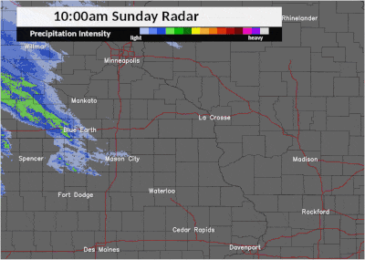
Radar Loops:
 |
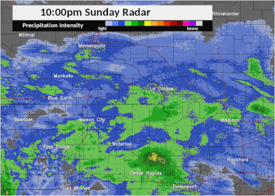 |
| 10 am - 10 pm Mar 12 | 10 pm Mar 12 - 10 am Mar 13 |
 |
Media use of NWS Web News Stories is encouraged! Please acknowledge the NWS as the source of any news information accessed from this site. |
|


 Weather Story
 Weather Map
 Local Radar