| Temperatures | Precipitation | ||||||
| Month | High | Low | Average | Departure | Total | Departure | Snow |
| January | 25.4 | 9.4 | 17.4 | +5.9 | 0.91 | +0.13 | 7.3 |
| February | 20.7 | 1.7 | 11.2 | -5.9 | 1.06 | +0.32 | 7.4 |
| March | 31.3 | 16.6 | 24.0 | -5.8 | 1.39 | -0.39 | 10.2 |
| April | 57.3 | 38.0 | 47.7 | +2.8 | 7.30 | +4.57 | T |
| May | 66.4 | 48.8 | 57.6 | +0.8 | 7.19 | +3.79 | 0.0 |
| June | 76.5 | 56.3 | 66.4 | -0.1 | 5.05 | +1.33 | ... |
| July | 82.7 | 61.9 | 72.3 | +1.4 | 2.45 | -1.75 | ... |
| August | 78.6 | 59.2 | 68.9 | +0.7 | 4.77 | +0.89 | ... |
| September | 68.1 | 47.9 | 58.0 | -1.2 | 3.82 | +0.35 | ... |
| October | 56.3 | 36.9 | 46.6 | -1.3 | 1.71 | -0.61 | T |
| November | 54.7 | 36.1 | 45.4 | +12.8 | 2.06 | +0.45 | 0.4 |
| December | 33.4 | 19.3 | 26.4 | +9.2 | 1.39 | +0.36 | 2.2 |
| TOTALS: | 54.3 | 36.0 | 45.2 | +1.6 | 39.10 | +9.45 | *** |
Records
Temperature...
Highs:
Lows:
Highest Lows:
Lowest Highs:
Monthly:
Seasonal:
Yearly:
Precipitation...
One-day pcpn:
One-day snowfall:
Monthly pcpn:
Monthly snowfall:
Seasonal precipitation:
Yearly precipitation:
|
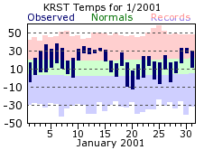
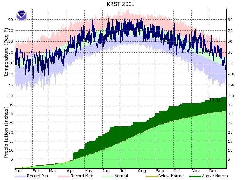
The year began on a mild note, which has become the norm when compared to the last several years. New Year’s day was a tad chilly, with low temperatures falling below zero. Within a few a days though, temperatures warmed to the mild readings the area has become accustom to. In fact, to find the last abnormally “cool” January one would have to travel back to 1996. That year, temperatures were 2 degrees below normal. January of 2001 was also relatively devoid of snow, with any significant snow storms skirting the area. The total of 7.3 inches was about two-thirds of normal.
|
 |
|
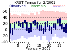
February made it look like the mild winter would continue...until mid-month that is. Temperatures took an about face from the 9th to the 10th, with highs going from 25 to 4 degrees. The month then stayed mostly near or below normal. Although temperatures felt more like winter, a “deep freeze” was avoided. Below zero readings were recorded on 14 days, 5 above the normal of 9 for February.
|
 |
|
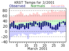
March continued the cooler than normal conditions, and it was also dry...except for one day. The last winter storm of the season would plow a path through the region on 12th, working shovels to the tune of 8.6 inches in the Rochester area. This late winter/early spring snow storm is not unprecedented. To the contrary, it is more the normal for the Upper Midwest. Every few years a winter storm of this magnitude effects the region, and the area was definitely due for a storm of this strength. The last significant late winter/early spring snow storm can be traced back to 1997, and was quite a doozy, dropping over 13 inches of the white stuff in a 3 day period. Still, if it wasn’t for this storm, March would have even been drier then it was. On only 5 days was measurable precipitation recorded, and there was a streak of 7 consecutive days without even a trace of precipitation.
|
 |
|
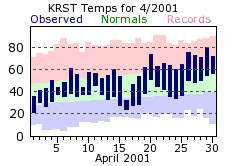
April brought a reversal of fortune when it came to precipitation, and to a fault. Rochester was over 4 ½ inches above normal for the month, and the 7.30 inch total made it the wettest April ever. Much of the wetting was thanks to one day, the 11th. On that day, 3.75 inches of rain fell from the sky, making it the 9th wettest day on record for Rochester. Even with the abundance of rain, temperatures were above normal for April. Temperatures cracked both the 70 degree barrier for the first time in 2001 on the 20th, and then reached 80 on the 29th.
|
 |
|
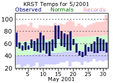
The wet weather continued in May, with monthly totals close to 4 inches above normal. The precipitation came in streaks, with 6 straight days with rainfall to start of the month, and another 8 consecutive days toward the end of the month. In between those, there was a 8 day span with only a trace of precipitation. During that dry period, the area got an early taste of summer, with temperatures nearing the 90 degree mark on the 14th and 15th. This taste of warmth would be misleading though, as cooler conditions settled in for month’s end, and would continue through the first part of June.
|
 |
|
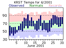
The streak of cool conditions would jump back into summer-time warmth after the first week of June, and then continue near or above normal for the rest of the month. June was also the most active month in terms of severe weather, with hail being the main severe weather event. The first of the traditional summer months would also be wet through the middle to late part of the month, then turn dry. This would be the start of the most significant streak of dry days the area has seen in a few years. What made it even more significant was its timing. Coming during the heart of summer as it did, the long and hot days would have a maximum impact upon area plant life.
|
 |
|
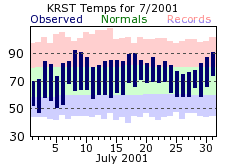
Rochester would go until July 18th before it would receive any significant precipitation, a streak of 26 straight days. During the streak only 0.02 inches of rain fell in Rochester, in marked contrast to the very wet spring and early part of the summer. Area lawns and foliage took a beating as sprinklers worked overtime to compensate for the arid conditions. Heat was also a factor for July with 4 days of 90 degree of better readings. As opposed to June, July was very quiet in regards to severe weather, as would be August
|
 |
|
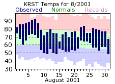
Yet more dry conditions would settle in for the start of August, leading to more worries of an extended drought. After around 1/8th of an inch on the 1st, there were another 12 straight days with only 0.03 inches falling. Mother Nature would finally relent by mid month, and much needed rain would fall on over half of the remaining days in August. And even after the dry start, August would finish almost an inch above normal for rainfall. Heat continued to be a story for the first part of August, and came hand in hand with the dry streak. Mercuries cracked 90 twice (6th and 7th), and for the last time in 2001.
|
 |
|
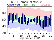
September transitioned quickly from the warmth of the summer months, to temperatures more typical of early fall. Rainfall for the month was a bit above normal, with over half of the month total falling on the 21st and 22nd. All in all, September, along with October, were the most “normal” months of the past year, lacking the streaky weather conditions of the other months.
|
 |
|
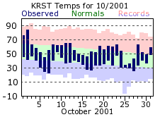
October was slightly below normal for both temperatures and precipitation, with an interesting swing at the start of the month. On the 2nd, the last 80 degree or greater day graced the area. However, the first freezing day of the early fall season would come quickly on its heels, with a 31 degree reading on the morning of the 5th. The first few flurries of the new snowfall season also came on the 6th, with a trace of snow falling. Wind was also a story for October, with strong and gusty winds from the 24th through the 26th. Winds averaged over 32 mph on the 25th, with a peak gust around 55 mph. With high temperatures on the 25th and 26th in the middle 30s, wind chills also became a factor.
|
 |
|
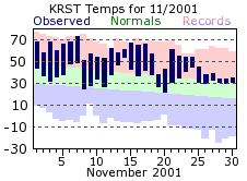
November made it feel more like early spring rather than the tail end of fall, and ended up as the warmest November on record at 45.4 degrees. This thoroughly crushed the old record of 40.4 degrees, which was set in 1913. November was the only month of this past year where every day averaged above normal, and low temperatures only dropped to freezing on 12 occasions. This is well under the normal number of 23 such days. The last 70 degree day of the year also happened in November, on the 7th. This was about 10 days off of the record for latest 70 degree occurrence, which is November 16th of 1953 for Rochester.
|
 |
|
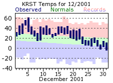
December continued the string of above normal temperatures, not recording a below normal day until Christmas Eve. This marked the end of a string of 57 consecutive days with above normal temperatures (Oct. 28th through Dec 23rd). This is the longest string of above normal temperatures since the El Nino winter of 1998. The abnormally mild conditions also led to more unusual weather...the lack of snow. The first measurable snow for Rochester waited until November 30th, with only an additional 0.6 inches falling on the 7th of December. With nary a flake through the middle part of the month, the chances for a non-white Christmas loomed large. However, Santa brought an early Christmas present, with an inch of snow on the 23rd, thus insuring a white Christmas. Temperatures and conditions more suitable for the season then rounded out the month.
|
 |
|
This past year can best be described as a year of streaks, and made for the most interesting weather stories for 2001. Whether it be extended cold or hot spells, or bouts with an abundance of rain or lack thereof...the Rochester area was defined more by the extremes rather than the mundane.
|
 |
| Highest temperature for 2001 | 92 on June 11th, July 8th, and August 7th |
| Lowest temperature for 2001 | -18 on February 2nd |
| Highest one-day precipitation | 3.75 inches on March 12th |
| Highest one-day snowfall | 8.6 inches on March 12th |
| Number of days with highs at or above 90 degrees | 10 |
| Number of days with highs at or below 32 degrees | 78 |
| Number of days with zero or below temperatures | 23 |
| Peak wind gust | 62 mph from the southwest on April 7th |
| Number of days with measurable precipitation | 124 |
| Percentage of days with measurable precipitation | 34% |
| Number of days with above normal temperatures | 207 |
| Percentage of days with above normal temperatures | 57% |


 Weather Story
 Weather Map
 Local Radar