| Temperatures | Precipitation | ||||||
| Month | High | Low | Average | Departure | Total | Departure | Snow |
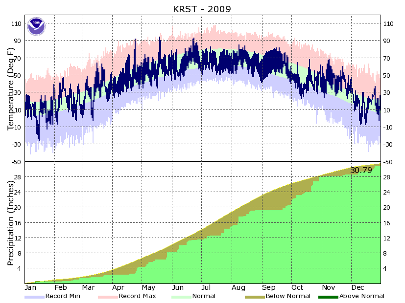
| January | 17.5 | -0.4 | 8.5 | -3.3 | 0.64 | -0.30 | 9.8 |
| February | 29.0 | 12.4 | 20.7 | +2.3 | 0.79 | +0.04 | 8.0 |
| March | 41.9 | 23.6 | 32.8 | +2.2 | 0.88 | -1.00 | 1.2 |
| April | 57.9 | 34.4 | 46.1 | +1.4 | 2.09 | -0.92 | 0.6 |
| May | 68.8 | 47.1 | 58.0 | +1.1 | 3.87 | +0.34 | ... |
| June | 75.3 | 56.4 | 65.9 | -0.2 | 3.33 | -0.67 | ... |
| July | 75.1 | 55.5 | 65.3 | -4.8 | 3.51 | -1.10 | T |
| August | 75.1 | 56.3 | 65.7 | -2.0 | 4.16 | -0.17 | ... |
| September | 73.8 | 51.4 | 62.6 | +3.7 | 1.28 | -1.84 | ... |
| October | 49.8 | 35.3 | 42.5 | -4.5 | 7.57 | +5.37 | 7.9 |
| November | 51.8 | 33.8 | 42.8 | +11.6 | 0.45 | -1.56 | 0.2 |
| December | 22.9 | 2.1 | 12.5 | -4.8 | 1.52 | +0.50 | 28.6 |
| TOTALS: | 53.0 | 34.2 | 43.6 | +0.1 | 30.79 | -0.61 | *** |
Records
Temperature...
Highs:
Lows:
Highest Lows:
Lowest Highs:
Monthly:
Seasonal:
Yearly:
Precipitation...
One-day pcpn:
One-day snowfall:
Monthly pcpn:
Monthly snowfall:
Seasonal precipitation:
Yearly precipitation:
|
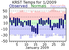
January got 2009 off to a chilly start. The middle part of the month was particularly frigid as low temperatures tumbled well below zero on the 13th through the 16th, with high temperatures never climbing above zero on the 14th or 15th. The coldest temperature of the year occurred on the 16th when morning lows were a frosty -26 degrees. Overall, there were 14 days with lows at or below zero and the 8.5 degree average temperature was the coldest since 1994. Snowfall for the month was close to the January normal, with 9.8 inches falling. Half of this came on the 12th, with six other days recording a tenth of an inch or better. There was an icing event on the 3rd and 4th as freezing drizzle was widespread across the region. While accumulations were relatively small, the icing that occurred made for very treacherous travel. |
 |
|
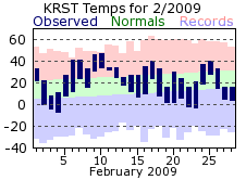
February’s average temperature was above normal thanks to a very mild stretch near the start of the month. From the 6th through the 12th the average temperature was 16 degrees above normal, with highs topping 40 four times and low temperatures closer to the normal highs. Precipitation and snowfall for February were right around the normal. However, nearly all of February’s precipitation came in the last half of the month. From the 1st though the 17th only a tenth of an inch of precipitation fell with only a trace of that as snow. Overall, there were only 4 days with measurable snowfall. Some thunder was heard in February though, with a few rumbles on the 26th. |
 |
|
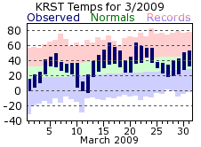
March was another mild month on the whole; however, there was a lot variance in the day to day temperatures. The month started off a bit chilly, but warmed until the 11th and 12th when temperatures tumbled to readings more reminiscent of January. The last below zero degree day of the 2008-09 winter was on the 12th with a low of -3. It warmed quickly after that, with highs even topping 60 on the 16th and 21st. Some cold air would return before month’s end though, with highs only managing the 30s on the 25th through 27th. Precipitation was below normal with nearly the entire month’s total falling on 4 days. Snowfall was also sparse, with the 1.2 inch monthly total falling on just one day (the 8th). This meager amount also made this last March the 5th least snowy March on record for Rochester. |
 |
|
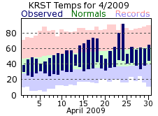
April continued the trend of above normal monthly temperatures and was fairly consistent with a gradual warm-up through the month. There was one significant aberration though…as temperatures rocketed to a high of 92 on the 24th ahead of a cold front, then struggled to reach 53 degrees for a high on the 25th behind the front. April was about an inch below normal for precipitation. There was a stretch of 12 days where no rain fell (6th through 17th) with the driest further accentuated by 80% of the monthly total falling on 4 consecutive days (24th through 27th). The last measurable snowfall of the 2008-09 winter season fell on the 5th with 0.6 inches. |
 |
|
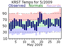
May continued the above normal temperature trend, with most days hovering near, or slightly above normal. However, the 19th and 20th brought a burst of some summer heat with highs climbing to 90 or greater (the hottest day of the year was on the 19th with 94 degrees). Oddly, these were the only days where the high temperature exceeded 80 degrees, let alone 90. Precipitation was just a bit above normal for May along with being more spread out. There were 9 days where at least a tenth of an inch fell. The wettest period came on the 26th and 27th with 1.88 inches falling over those two days. |
 |
|
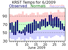
June temperatures were right around the monthly normal, although the month got off to a cool start with highs only in the 50s on the 6th, 7th and 8th. Temperatures would start to moderate after that, with a couple more 90 degree days then on the 22nd and 23rd. Precipitation was around ½ inch below normal for June, but like May, what fell was spread across the month. After dry conditions for the first 5 days, there was never more than 3 consecutive days without measurable precipitation. Out of the 12 days where measurable rain fell, half of those recorded two-tenths of an inch or more. |
 |
|
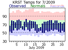
July saw considerably colder conditions compared to what had been a relatively mild first half of the year. Temperatures were at or below the monthly normal on every day but one (the 10th) with nearly as many days with highs in the 60s (4) as there were in the 80s (5). The 65.3 degree average temperature made it the 2nd coldest July on record for Rochester (the coldest coming in 1992 at 64.2 degrees). Precipitation was below normal for the second consecutive month. Measurable rain fell on 11 days, but the bulk of the accumulations came on four of those. The four comprised over 80% of the monthly total, with around ½ inch or more falling on each day. |
 |
|
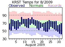
August stayed cool and was fairly consistent on a day to day basis. The only relatively warm stretch, which was more seasonable than hot, was from the 8th through the 14th when daytime highs reached or exceeded 80 degrees on 6 of the 7 days. Similar to July, there were nearly as many days with highs in the 60s (5) as there were in the 80s (6). Rainfall was right around the monthly normal. However, nearly all of the rain fell in the first two-thirds of the month. After the 21st, only 0.08 inches of rain fell (all on the 25th). This would be the beginning of a very long dry streak that would extend well into September. |
 |
|
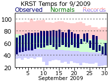
September might be remembered as the most pleasant month of 2009 as a nearly month long spate of dry, clear, and mild conditions reigned. The dry conditions were definitely the highlight though, as rain did not fall until the 21st of the month. This was the driest start to any September on record for Rochester, and the string of 26 days without even a trace of rainfall (August 26th-September 20th) was the 6th longest streak of its kind. The dry weather was a result of persistent high pressure, which also led to many sunny days with light winds. There were 23 days where the sky conditions were considered clear, well above the average of 9 days in a typical September. Also, the wind speed for the month averaged 6.5 mph, which made it the 4th least windy month on record for Rochester (July of 1953 was the least windy at 6.1 mph). As for temperatures, at or above normal readings were recorded on 23 of the 30 days. There were no significant warm-ups; rather nearly every day was a few degrees above the monthly normal. |
 |
|
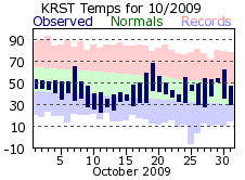
Flipping the calendar from September to October brought quite a change in the weather for the region, exchanging the mild and dry conditions for unseasonably cool and wet ones. The average temperature of 42.5 degrees made this October the 8th coldest on record for Rochester while the 7.57 inch precipitation total made it the 2nd wettest. Temperatures were below normal on 22 of the 31 days with the coldest stretch coming around mid-month. From the 9th through the 17th, high temperatures were at or below 50 degrees, with a very chilly high of 35 on the 12th. Lows were near or below freezing. These temperatures were more reflective of a typical November rather than October. Precipitation was plentiful with measurable rain or snow falling on 18 days. The normal is only 9. An inch or greater of liquid precipitation was recorded on 4 of those days. The first measurable snowfall of the winter season came on the 11th when 0.9 inches fell. Measurable snow would fall 4 more times in the month, with a high of 4.2 inches on the 23rd. Several daily records were set, and the monthly total of 7.9 inches made it the snowiest October on record for Rochester. |
 |
|
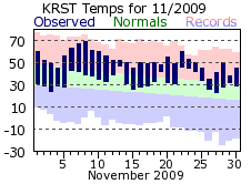
While October seemed more like November when it came to temperatures, November returned the favor by feeling more like October. November temperatures were at or above normal on every day but one. The monthly average of 42.8 degrees made it the 2nd warmest November on record. This also marked the first time (on record) that November has been warmer than October in the same year at Rochester. Mother Nature’s faucet shutoff in November as measurable precipitation fell on 5 days. Snow only fell twice in November for a monthly total of 0.2 inches. This meager amount made it the 8th least snowy November on record for Rochester. |
 |
|
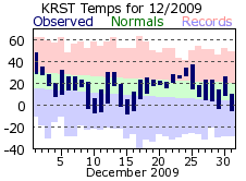
While November hinted that perhaps winter would start out mild and dry, Mother Nature quickly brought an end to those thoughts in December. A major winter storm struck the region on the 7th through the 9th with over a foot of snow common along with blizzard to near blizzard conditions at times. At Rochester, 12.8 inches of snow fell on the 8th and 9th with snowfall records being set for both days. Another winter storm would then move across the region just before and then through the Christmas holiday. However, warmer air accompanied this storm, and as a result the precipitation was more mixed: rain, snow, freezing rain and sleet. Snow accumulations were much less as a result, but some icy conditions did develop from time to time, and the winter storm made for some hazardous travel near the holiday. Overall, the 26.3 inch snow total made this the 4th snowiest December on record. The liquid equivalent total of 2.22 inches also made it the 4th wettest December. Temperatures were a bit colder than normal for December but most of this cold came in the days after each of the winter storms. Otherwise, temperatures were around or a bit above the December normals.
|
 |
|
Overall, 2009 will be remembered for its very cool summer, an interesting fall with an extremely wet and cool October followed by a dry and very mild November, and the winter storms of December bringing record snowfall and other wintery precipitation to the region.
|
 |
| Highest temperature for 2009 | 94 on May 19th |
| Lowest temperature for 2009 | --26 on January 16th |
| Highest one-day precipitation | 1.67 inches on August 8th |
| Highest one-day snowfall | 8.3 inches on December 8th |
| Number of days with highs at or above 90 degrees | 5 |
| Number of days with highs at or below 32 degrees | 76 |
| Number of days with zero or below temperatures | 30 |
| Peak wind gust | 55 mph from the south on May 20th |
| Number of days with measurable precipitation | 115 |
| Percentage of days with measurable precipitation | 32% |
| Number of days with above normal temperatures | 173 |
| Percentage of days with above normal temperatures | 47% |


 Weather Story
 Weather Map
 Local Radar