Overview
|
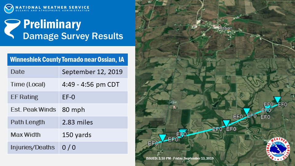
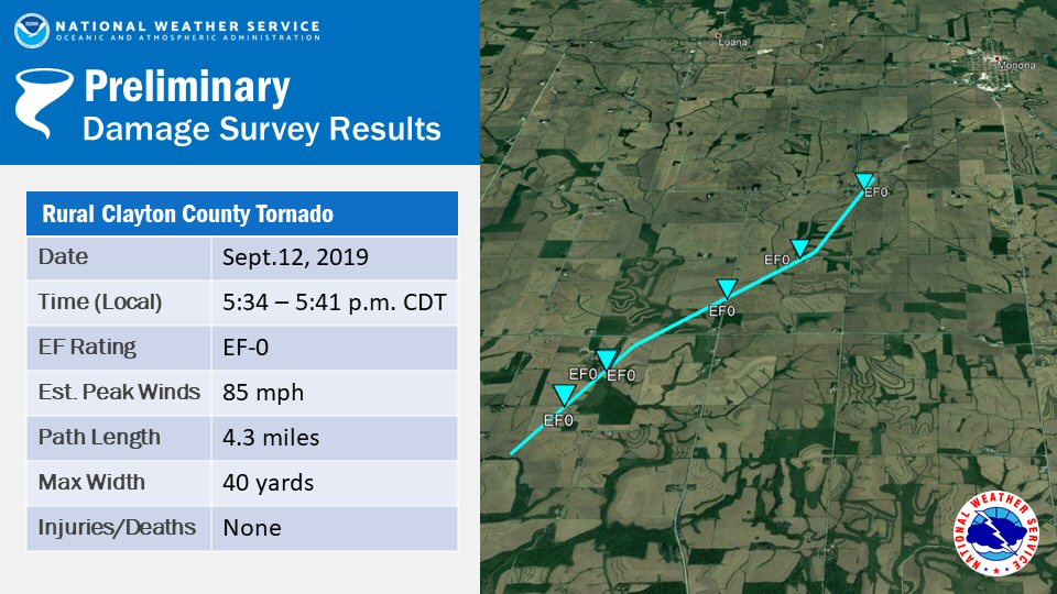
Strong to severe thunderstorms rolled across the area from early afternoon through the late evening hours of Thursday, September 12th. The storms produced very heavy rainfall, resulting in flash flooding across portions of northeast Iowa and southwest Wisconsin, along with rises on many rivers and streams. In addition, strong to damaging winds accompanied some of the storms. EF-0 tornadoes touched down in rural Winneshiek County, Iowa just south of the town of Ossian, and in rural northwest Clayton County, Iowa southwest of Monona.
|
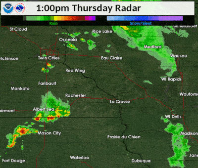 Radar loop from 1 to 7 p.m. (Sept.12) |
Tornadoes:
|
Tornado - South of Ossian, IA
|
||||||||||||||||
|
Tornado - Southwest of Monona, IA
|
||||||||||||||||
The Enhanced Fujita (EF) Scale classifies tornadoes into the following categories:
| EF0 Weak 65-85 mph |
EF1 Moderate 86-110 mph |
EF2 Significant 111-135 mph |
EF3 Severe 136-165 mph |
EF4 Extreme 166-200 mph |
EF5 Catastrophic 200+ mph |
 |
|||||
Wind:
Public Information Statement
National Weather Service La Crosse WI
845 PM CDT Thu Sep 12 2019

...HIGHEST WIND REPORTS TODAY...

Location                     Speed     Time/Date       Lat/Lon
Mayo Helipad                 44 MPH    0316 PM 09/12   44.02N/92.48W
1 ENE Dexter                 42 MPH    0135 PM 09/12   43.73N/92.68W
Jct CR 7 I-90 Mile Post 226  38 MPH    0405 PM 09/12   43.96N/92.21W
Oelwein Municipal Airport    37 MPH    0435 PM 09/12   42.67N/91.97W
2 ESE Canton                 37 MPH    0430 PM 09/12   43.52N/91.89W
Boscobel Airport             35 MPH    0646 PM 09/12   43.15N/90.68W
Rochester International Airp 33 MPH    0412 PM 09/12   43.90N/92.50W
Boscobel                     31 MPH    0703 PM 09/12   43.15N/90.68W
2 E Kasson                   30 MPH    1115 AM 09/12   44.02N/92.71W
Austin Municipal Airport     29 MPH    0137 PM 09/12   43.67N/92.92W
Decorah Municipal Airport    29 MPH    0455 PM 09/12   43.27N/91.72W
3 N Stewartville             29 MPH    0210 PM 09/12   43.90N/92.48W
5 NW Frankville              29 MPH    0532 PM 09/12   43.25N/91.70W
Gilman                       28 MPH    0635 PM 09/12   45.17N/90.82W
St. Joseph 3W                27 MPH    0209 PM 09/12   43.78N/91.10W
Lake City                    27 MPH    0331 PM 09/12   44.32N/92.44W
Lake City                    26 MPH    0347 PM 09/12   44.45N/92.27W
Riceville                    26 MPH    0401 PM 09/12   43.40N/92.50W
Charles City Airport         26 MPH    0355 PM 09/12   43.07N/92.62W
Preston Airport              26 MPH    0419 PM 09/12   43.68N/92.17W
La Crosse Regional Airport   26 MPH    0726 PM 09/12   43.88N/91.25W
Medford Airport              26 MPH    0455 PM 09/12   45.10N/90.30W
Platteville Municipal Airpor 26 MPH    0755 PM 09/12   42.68N/90.43W
1 E Ridgeway                 26 MPH    0145 PM 09/12   43.91N/91.54W
2 E Cataract                 25 MPH    0323 PM 09/12   44.09N/90.79W
3 NE Lublin                  25 MPH    0714 PM 09/12   45.11N/90.69W
Rochester                    25 MPH    0130 PM 09/12   44.18N/92.41W
Sparta/Fort McCoy Airport    25 MPH    0615 PM 09/12   43.97N/90.73W
Dodge Center Airport         25 MPH    0316 PM 09/12   44.02N/92.82W
Necedah                      25 MPH    0748 PM 09/12   44.03N/90.08W
Medford                      24 MPH    0516 PM 09/12   45.30N/90.30W
Winona Municipal Airport     24 MPH    0752 PM 09/12   44.07N/91.70W
Volk Field                   24 MPH    0621 PM 09/12   43.92N/90.27W
Viroqua Municipal Airport    24 MPH    0535 PM 09/12   43.58N/90.90W
1 SW Mount Sterling          24 MPH    1006 AM 09/12   43.31N/90.94W
2 N Ionia                    24 MPH    0420 PM 09/12   43.07N/92.46W
Rochester                    23 MPH    1149 AM 09/12   44.04N/92.44W
Trempealeau                  23 MPH    0755 PM 09/12   44.07N/91.51W
Saratoga                     23 MPH    0401 PM 09/12   43.35N/92.42W
Prairie Du Chien  Airport    23 MPH    0635 PM 09/12   43.02N/91.12W
1 E Black River Falls        22 MPH    0715 PM 09/12   44.30N/90.73W
Rochester                    22 MPH    1220 PM 09/12   44.05N/92.45W
1 SSE Kellogg                22 MPH    0610 PM 09/12   44.28N/91.99W
Rochester                    21 MPH    0446 PM 09/12   44.08N/92.52W
La Crosse                    20 MPH    0416 PM 09/12   43.77N/91.22W
Hayfield                     20 MPH    1117 AM 09/12   43.89N/92.85W
Byron                        20 MPH    0346 PM 09/12   44.04N/92.64W
Byron                        20 MPH    0834 PM 09/12   44.03N/92.66W
Wabasha                      20 MPH    0558 PM 09/12   44.30N/92.00W
Black River Falls Area Airpo 20 MPH    0255 PM 09/12   44.25N/90.85W


Observations are collected from a variety of sources with varying
equipment and exposures. We thank all volunteer weather observers
for their dedication. Not all data listed are considered official.
Flooding
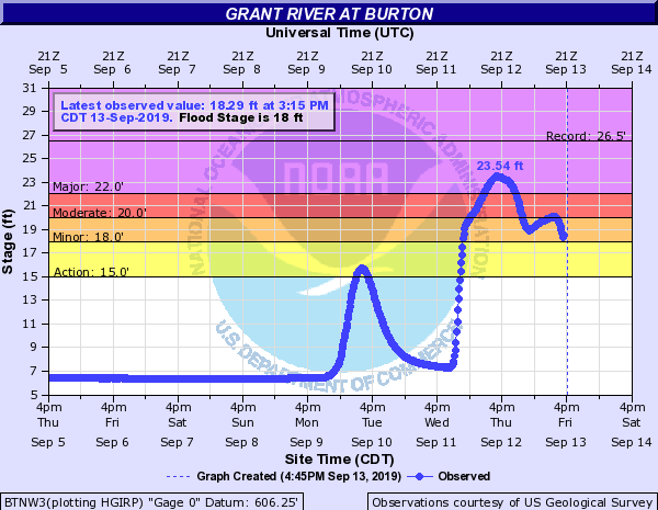
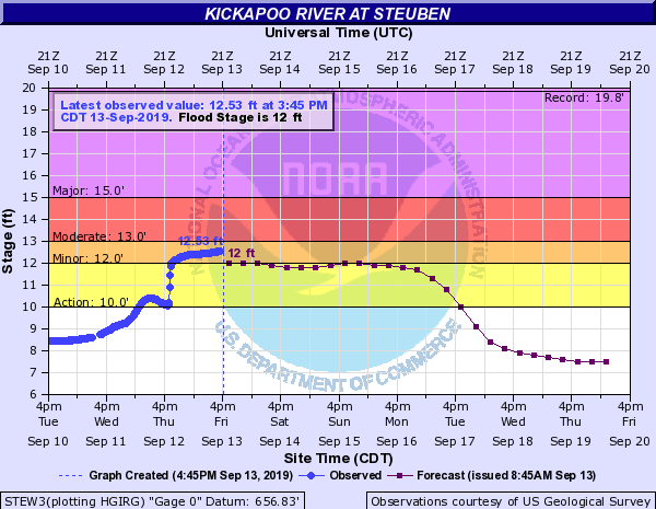
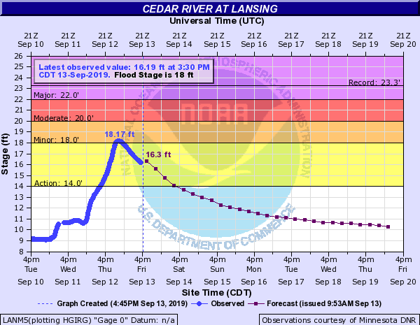
Hydrographs
 |
 |
 |
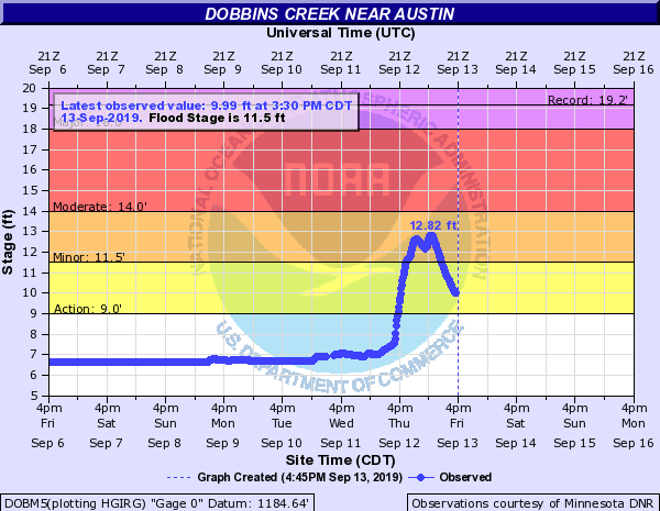 |
| Grant River at Burton, WI | Kickapoo River at Steuben, WI | Cedar River at Lansing, MN | Dobbins Creek near Austin, MN |
Photos:
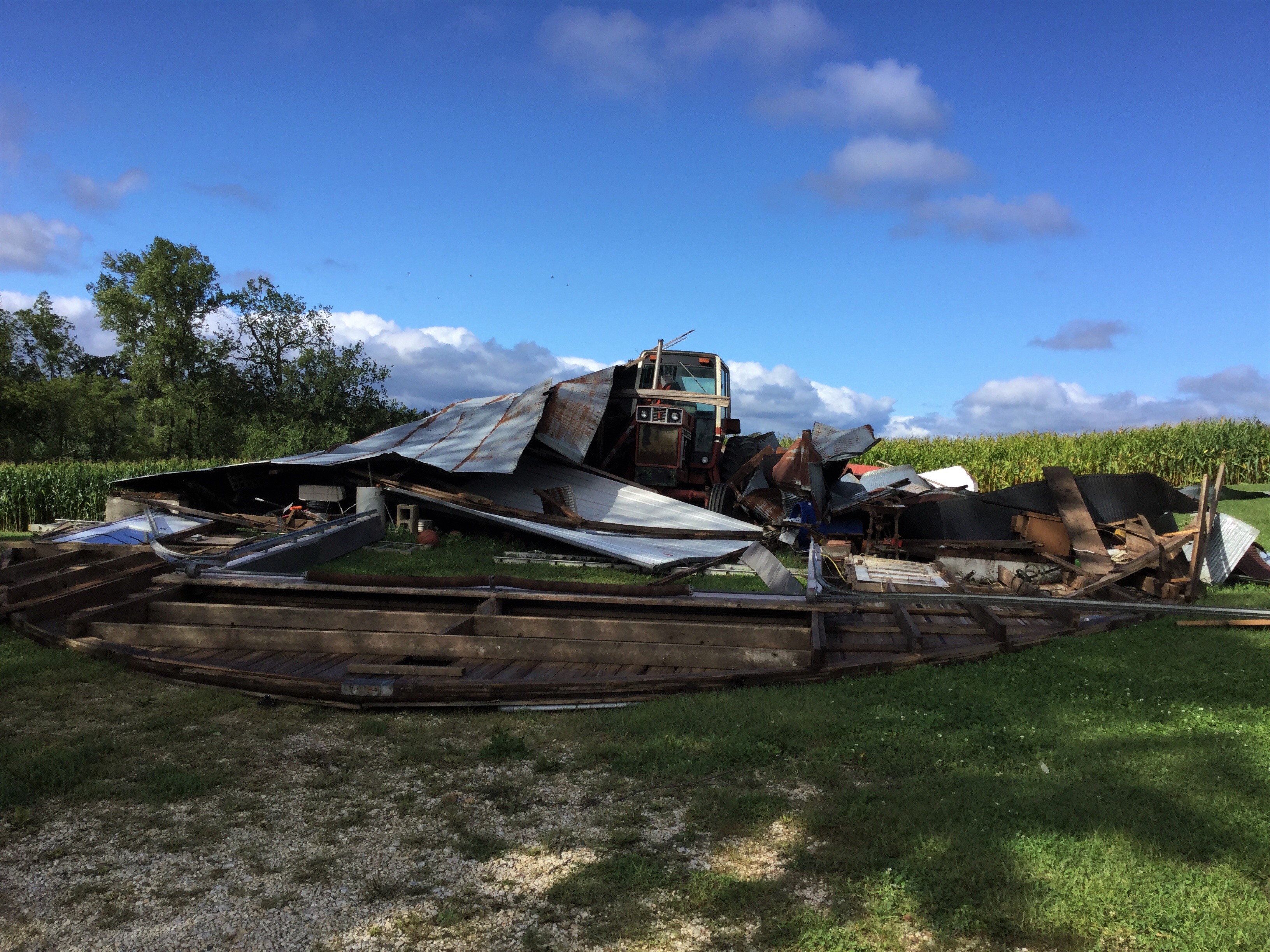
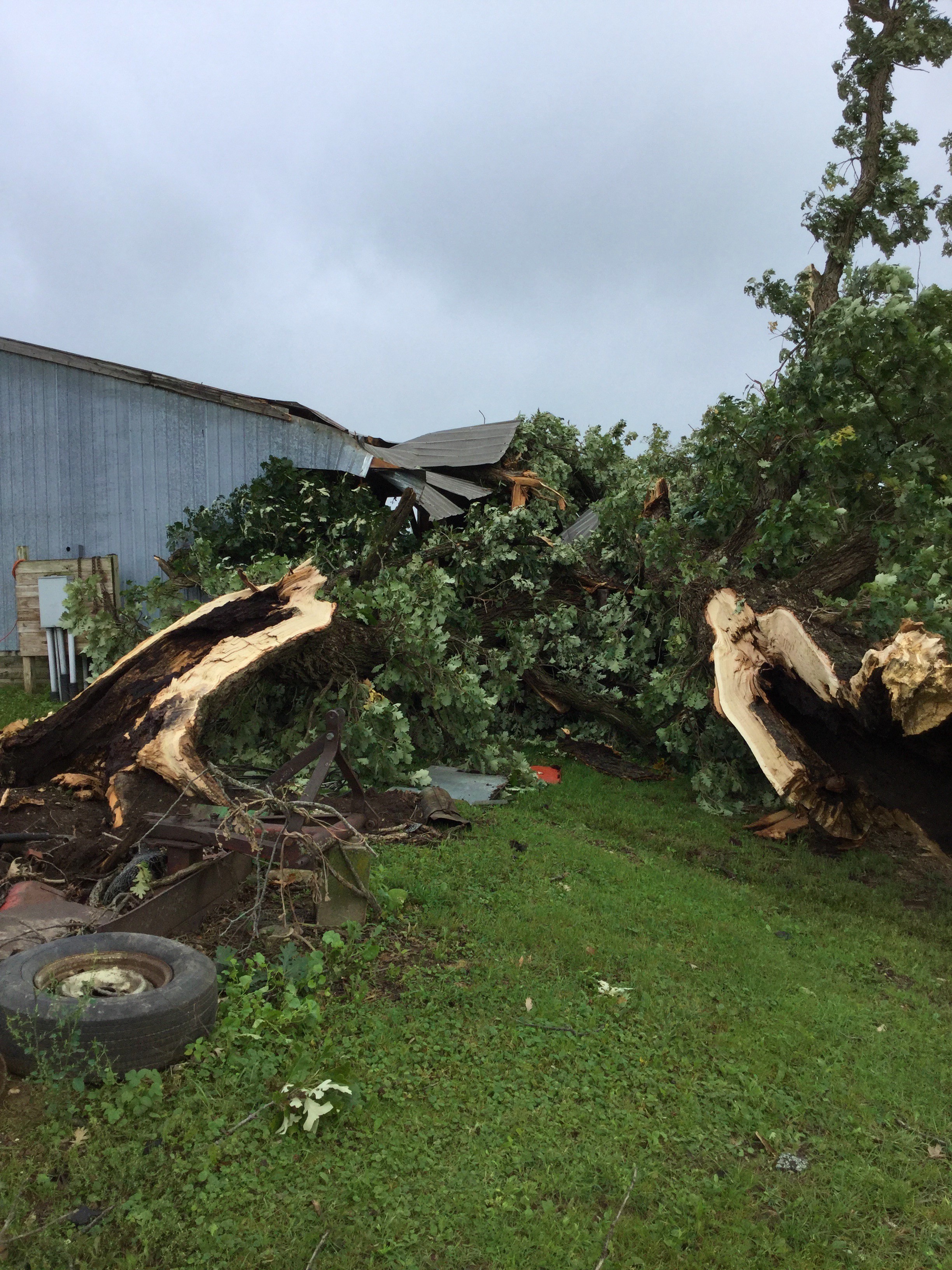
EF0 Tornado South of Ossian, IA in rural Winneshiek County, IA |
|||
 |
 |
 |
|
| Damage to farm outbuilding (NWS La Crosse) |
Tree damage near the start of the tornado. Note tree is rotten, so it takes less wind to cause damage. (NWS La Crosse) |
Corn and building damage (NWS La Crosse) |
|
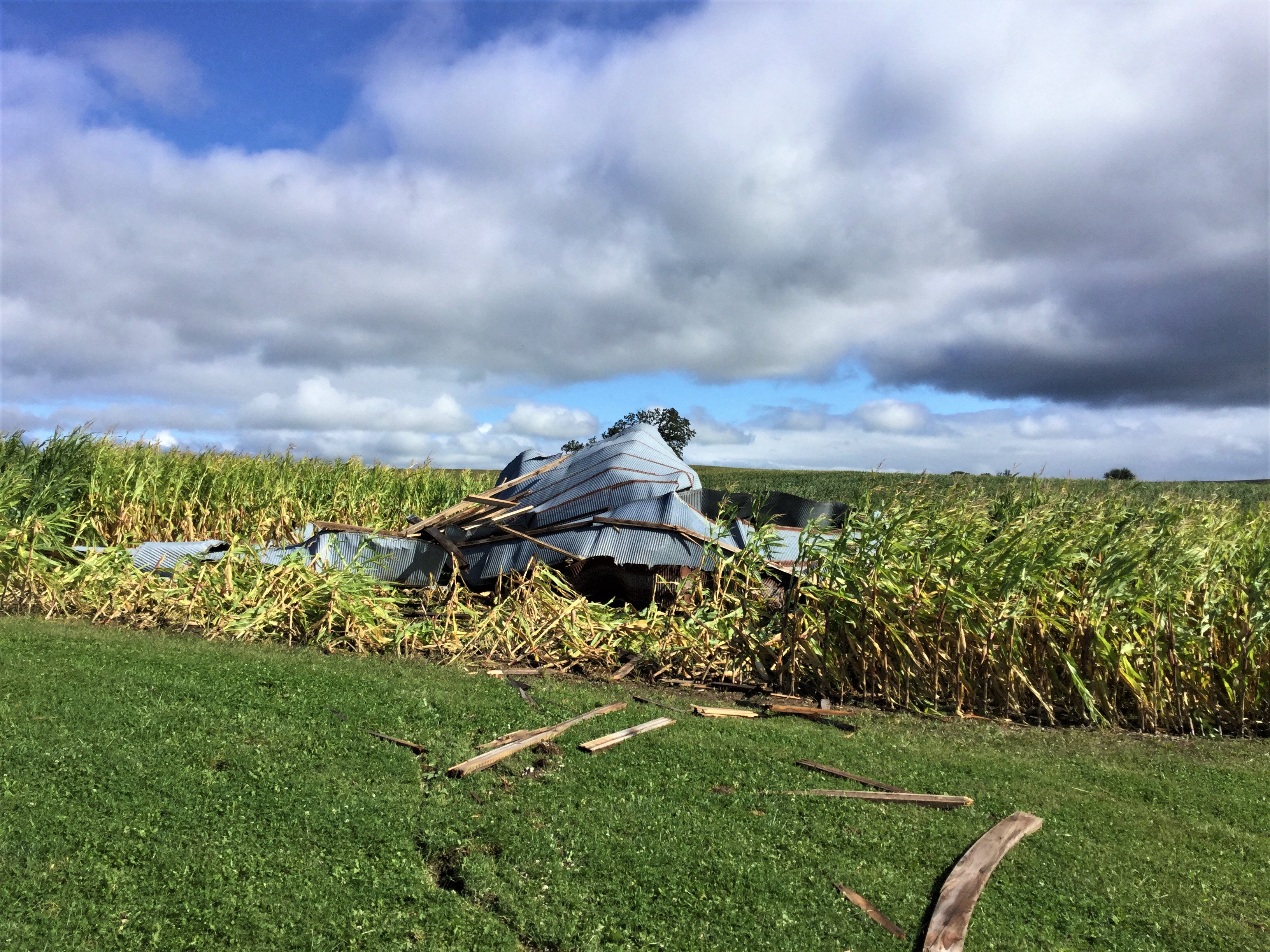
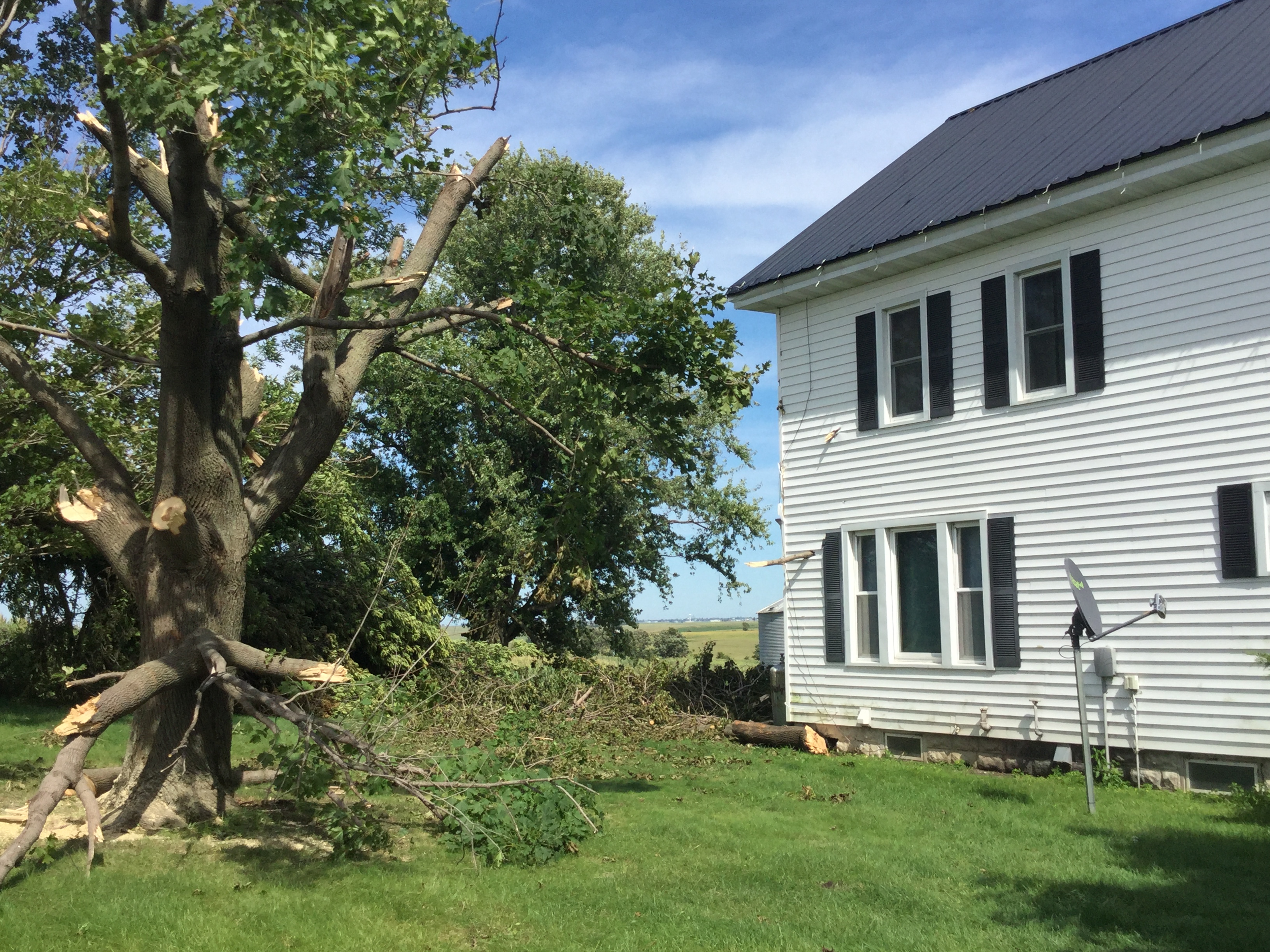
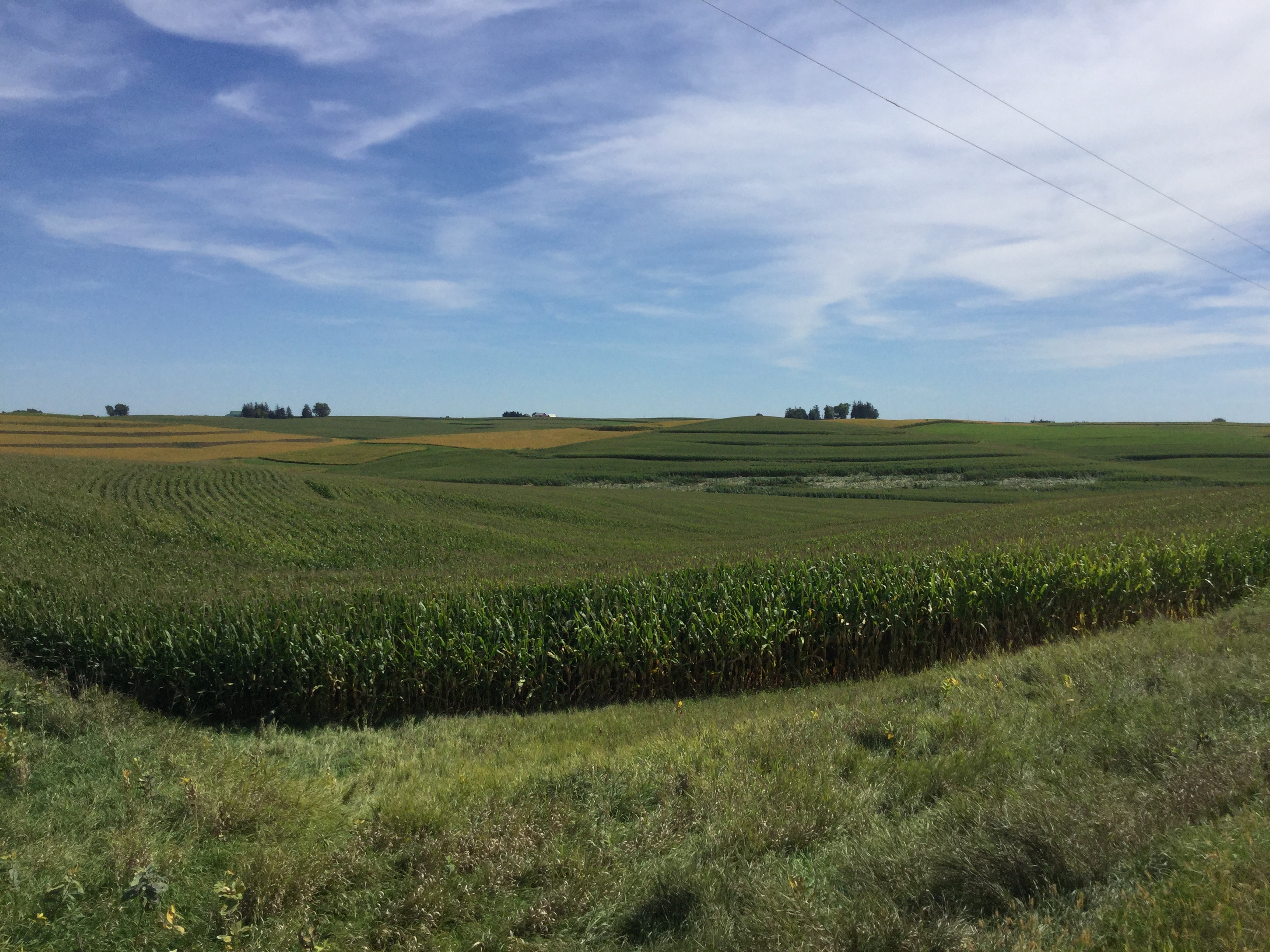
EF0 Tornado in Rural Northwest Clayton County, IA |
|||
 |
 |
||
| Tree branches impaled through sidewalls of a nearby house. (NWS La Crosse) |
Tornado track through a cornfield. (NWS La Crosse) |
||
Storm Reports
PRELIMINARY LOCAL STORM REPORT...SUMMARY
NATIONAL WEATHER SERVICE LA CROSSE WI
714 PM CDT THU SEP 12 2019

..TIME...   ...EVENT...      ...CITY LOCATION...     ...LAT.LON...
..DATE...   ....MAG....      ..COUNTY LOCATION..ST.. ...SOURCE....
            ..REMARKS..

0309 PM     FLOOD            AUSTIN                  43.67N 92.97W
09/12/2019                   MOWER              MN   LAW ENFORCEMENT

            EXTENSIVE STREET FLOODING IN TOWN WITH
            STRANDED MOTORISTS AND WATER ON PARTS OF
            I-90.

0310 PM     HEAVY RAIN       2 NW LYLE               43.53N 92.97W
09/12/2019  M2.50 INCH       MOWER              MN   TRAINED SPOTTER

            SINCE 130 PM.

0327 PM     FLOOD            AUSTIN                  43.67N 92.97W
09/12/2019                   MOWER              MN   LAW ENFORCEMENT

            INTERSTATE 90 BETWEEN HWY 218 AND HWY 56
            CLOSED DUE TO HIGH WATER.

0346 PM     TSTM WND GST     3 SW CHESTER            43.46N 92.41W
09/12/2019  M54 MPH          HOWARD             IA   STORM CHASER

            VIA SPOTTERNETWORK.ORG.

0410 PM     TSTM WND GST     4 S GREENLEAFTON        43.52N 92.22W
09/12/2019  M70 MPH          FILLMORE           MN   TRAINED SPOTTER


0437 PM     LIGHTNING        ROLLINGSTONE            44.10N 91.82W
09/12/2019                   WINONA             MN   EMERGENCY MNGR

            HOUSE FIRE REPORTED BY LIGHTNING.

0454 PM     TORNADO          3 SSE OSSIAN            43.11N 91.74W
09/12/2019                   WINNESHIEK         IA   EMERGENCY MNGR

            POSSIBLE TORNADO DAMAGE ABOUT 2.5 MILES
            SOUTH SOUTHEAST OF OSSIAN.

0454 PM     HEAVY RAIN       LIME SPRINGS            43.45N 92.28W
09/12/2019  M2.40 INCH       HOWARD             IA   BROADCAST MEDIA

            FELL IN 45 MINUTES. RELAYED VIA MEDIA.

0455 PM     TORNADO          2 SW OSSIAN             43.13N 91.79W
09/12/2019                   WINNESHIEK         IA   FIRE DEPT/RESCUE

            JUST SPOTTED ALONG HWY W14.

0500 PM     FLOOD            3 ENE SARATOGA          43.39N 92.36W
09/12/2019                   HOWARD             IA   PUBLIC

            GRAVEL ROADS WASHED OUT AND WATER OVER
            GRAVEL ROADS ON KENT AVENUE EAST OF
            SARATOGA.

0509 PM     TSTM WND DMG     3 SW ALTA VISTA         43.16N 92.46W
09/12/2019                   CHICKASAW          IA   TRAINED SPOTTER

            TRAINED SPOTTER REPORTED TOPS OF TREES BLOWN
            DOWN ON ROADWAY SEVEN MILES EAST OF COLWELL.

0520 PM     HEAVY RAIN       AUSTIN                  43.67N 92.97W
09/12/2019  M3.16 INCH       MOWER              MN   PUBLIC

            RAINFALL SINCE 7AM THURSDAY.

0534 PM     HEAVY RAIN       ST. ANSGAR              43.38N 92.92W
09/12/2019  M3.97 INCH       MITCHELL           IA   CO-OP OBSERVER


0544 PM     HEAVY RAIN       8 W CHATFIELD           43.84N 92.35W
09/12/2019  M3.10 INCH       FILLMORE           MN   AMATEUR RADIO


0551 PM     FLOOD            ROSE CREEK              43.60N 92.83W
09/12/2019                   MOWER              MN   BROADCAST MEDIA

            WATER OVER ROAD IN VARIOUS SPOTS.

0555 PM     FLOOD            LA CROSSE               43.81N 91.25W
09/12/2019                   LA CROSSE          WI   LAW ENFORCEMENT

            STREET FLOODING REPORTED AROUND TOWN.

0604 PM     TSTM WND GST     CLAYTON CENTER          42.88N 91.32W
09/12/2019  E60 MPH          CLAYTON            IA   911 CALL CENTER


0619 PM     HEAVY RAIN       8 ENE DECORAH           43.34N 91.64W
09/12/2019  M2.42 INCH       WINNESHIEK         IA   PUBLIC

            FELL WITHIN ONE HOUR. FIELD AND DITCH
            FLOODING.

0644 PM     HEAVY RAIN       1 SE PRAIRIE DU CHIEN   43.03N 91.13W
09/12/2019  M1.85 INCH       CRAWFORD           WI   TRAINED SPOTTER

            ONE HOUR RAINFALL TOTAL.

0653 PM     FLASH FLOOD      WOODMAN                 43.09N 90.80W
09/12/2019                   GRANT              WI   EMERGENCY MNGR

            WASHOUTS AND MUDSLIDES REPORTED.

0653 PM     FLASH FLOOD      BLOOMINGTON             42.89N 90.93W
09/12/2019                   GRANT              WI   EMERGENCY MNGR

            WATER OVER ROADS IN BLOOMINGTON AREA.
Rain Reports
Public Information Statement
National Weather Service La Crosse WI
953 PM CDT Thu Sep 12 2019

...24 HOUR PRECIPITATION REPORTS...

Location                     Amount    Time/Date       Lat/Lon

...Iowa...

...Allamakee County...
5 SW Waukon Jct              1.28 in   0815 PM 09/12   43.11N/91.27W

...Chickasaw County...
Ionia 2W                     2.96 in   0800 PM 09/12   43.03N/92.50W
New Hampton                  0.85 in   0935 PM 09/12   43.06N/92.32W

...Clayton County...
Garber                       4.37 in   0900 PM 09/12   42.74N/91.26W
Mcgregor                     4.03 in   0934 PM 09/12   43.02N/91.19W
Monona                       2.90 in   0934 PM 09/12   43.04N/91.39W
Big Spring Fish Hatchery     2.46 in   0845 PM 09/12   42.91N/91.47W
1 WSW Marquette              1.01 in   0900 PM 09/12   43.04N/91.21W

...Fayette County...
3 ENE Randalia               1.10 in   0839 PM 09/12   42.88N/91.83W

...Floyd County...
Charles City                 0.59 in   0815 PM 09/12   43.06N/92.67W

...Howard County...
Riceville                    4.37 in   0932 PM 09/12   43.40N/92.50W

...Mitchell County...
St.Ansgar                    3.41 in   0926 PM 09/12   43.38N/92.92W

...Winneshiek County...
Decorah Municipal Airport    1.81 in   0915 PM 09/12   43.27N/91.72W
Decorah                      1.43 in   0934 PM 09/12   43.30N/91.79W

...Minnesota...

...Dodge County...
Hayfield                     2.78 in   0927 PM 09/12   43.89N/92.85W

...Fillmore County...
5 WSW Cummingsville          3.51 in   0831 PM 09/12   43.85N/92.35W
2 S Pilot Mound              2.30 in   0900 PM 09/12   43.78N/92.03W
Preston Airport              1.47 in   0916 PM 09/12   43.68N/92.17W

...Houston County...
1 NNE Houston                2.48 in   0800 PM 09/12   43.77N/91.57W
Houston                      1.80 in   0930 PM 09/12   43.79N/91.59W
1 SSE Brownsville            1.74 in   0830 PM 09/12   43.69N/91.27W
Mound Prairie                1.60 in   0830 PM 09/12   43.78N/91.45W

...Mower County...
Dobbins Creek                4.18 in   0745 PM 09/12   43.68N/92.94W
Lansing - Cedar River        3.77 in   0745 PM 09/12   43.75N/92.96W
Austin 3 NW - Turtle Creek   3.28 in   0800 PM 09/12   43.65N/92.98W

...Olmsted County...
5 WSW Rochester              2.97 in   0900 PM 09/12   43.98N/92.56W
3 W Rochester                2.86 in   0800 PM 09/12   44.02N/92.53W
Rochester International Airp 2.58 in   0854 PM 09/12   43.90N/92.50W
6 NNW Genoa                  2.50 in   0900 PM 09/12   44.19N/92.65W
Mayo Helipad                 2.46 in   0915 PM 09/12   44.02N/92.48W
Elgin 5SE                    2.30 in   0800 PM 09/12   44.08N/92.19W
Byron                        2.15 in   0930 PM 09/12   44.04N/92.64W
1 W Oronoco                  1.98 in   0900 PM 09/12   44.17N/92.55W
Byron                        1.81 in   0934 PM 09/12   44.03N/92.66W
Rochester                    1.49 in   0930 PM 09/12   44.09N/92.49W
Rochester                    1.28 in   0931 PM 09/12   44.08N/92.52W
Rochester                    1.26 in   0931 PM 09/12   44.18N/92.41W
Rochester                    1.16 in   0930 PM 09/12   44.09N/92.51W
Rochester                    0.91 in   0930 PM 09/12   44.05N/92.45W

...Wabasha County...
Wabasha                      2.34 in   0933 PM 09/12   44.30N/92.00W
Plainview                    2.33 in   0930 PM 09/12   44.17N/92.17W
Lake City                    1.54 in   0931 PM 09/12   44.32N/92.44W

...Winona County...
3 SW Elba                    3.79 in   0800 PM 09/12   44.06N/92.05W
1 WSW Elba                   3.65 in   0800 PM 09/12   44.09N/92.03W
Beaver                       2.22 in   0845 PM 09/12   44.15N/92.00W
3 NE Nodine                  2.21 in   0900 PM 09/12   43.94N/91.41W
Dakota                       1.73 in   0900 PM 09/12   43.91N/91.36W
Saint Charles                1.04 in   0935 PM 09/12   43.97N/92.06W

...Wisconsin...

...Buffalo County...
Cochrane                     2.62 in   0934 PM 09/12   44.22N/91.83W
Mondovi                      1.16 in   0700 PM 09/12   44.56N/91.67W

...Crawford County...
De Soto                      2.44 in   0926 PM 09/12   43.42N/91.19W
1 SSE Prairie Du Chien       1.85 in   0644 PM 09/12   43.03N/91.13W

...Grant County...
Boscobel Airport             4.22 in   0923 PM 09/12   43.15N/90.68W
Boscobel                     3.67 in   0903 PM 09/12   43.15N/90.68W
Fennimore                    2.23 in   0934 PM 09/12   42.98N/90.66W
Platteville Municipal Airpor 2.20 in   0915 PM 09/12   42.68N/90.43W

...Jackson County...
1 E Black River Falls        1.37 in   0915 PM 09/12   44.30N/90.73W

...Juneau County...
Mauston Airport              1.06 in   0915 PM 09/12   43.83N/90.13W
Mauston                      0.96 in   0932 PM 09/12   43.80N/90.07W
Volk Field                   0.65 in   0926 PM 09/12   43.92N/90.27W
Necedah 1w                   0.64 in   0848 PM 09/12   44.02N/90.08W

...La Crosse County...
NWS La Crosse                1.77 in   0908 PM 09/12   43.82N/91.19W
La Crosse Regional Airport   1.19 in   0925 PM 09/12   43.88N/91.25W

...Monroe County...
Sparta/Fort McCoy Airport    1.36 in   0915 PM 09/12   43.97N/90.73W
2 E Cataract                 1.30 in   0933 PM 09/12   44.09N/90.79W

...Richland County...
1 SSE Richland Center        2.27 in   0934 PM 09/12   43.32N/90.38W

...Taylor County...
3 NE Lublin                  0.69 in   0914 PM 09/12   45.11N/90.69W
Medford                      0.59 in   0931 PM 09/12   45.30N/90.30W

...Trempealeau County...
Trempealeau                  1.71 in   0930 PM 09/12   44.07N/91.51W

...Vernon County...
Viroqua Municipal Airport    1.31 in   0935 PM 09/12   43.58N/90.90W

Observations are collected from a variety of sources with varying
equipment and exposures. We thank all volunteer weather observers
for their dedication. Not all data listed are considered official.

$$
 |
Media use of NWS Web News Stories is encouraged! Please acknowledge the NWS as the source of any news information accessed from this site. |
|


 Weather Story
 Weather Map
 Local Radar