Overview
|
|
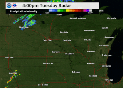 Radar loop of severe storms from September 24, 2019 |
Tornadoes:
|
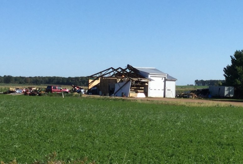
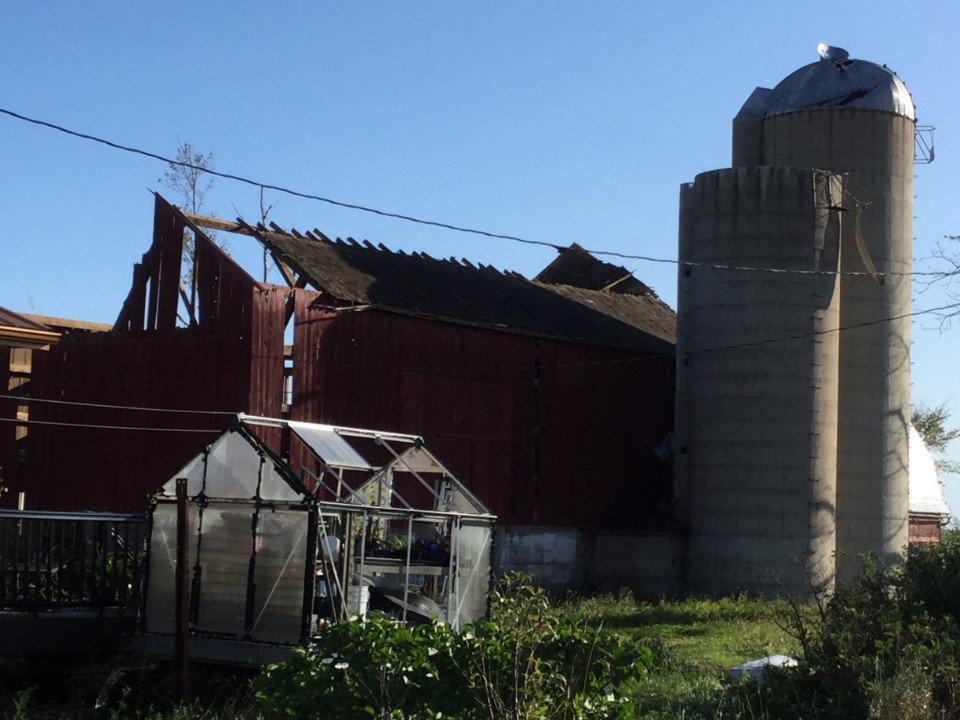
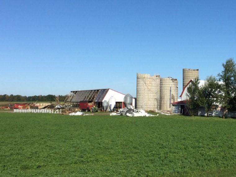
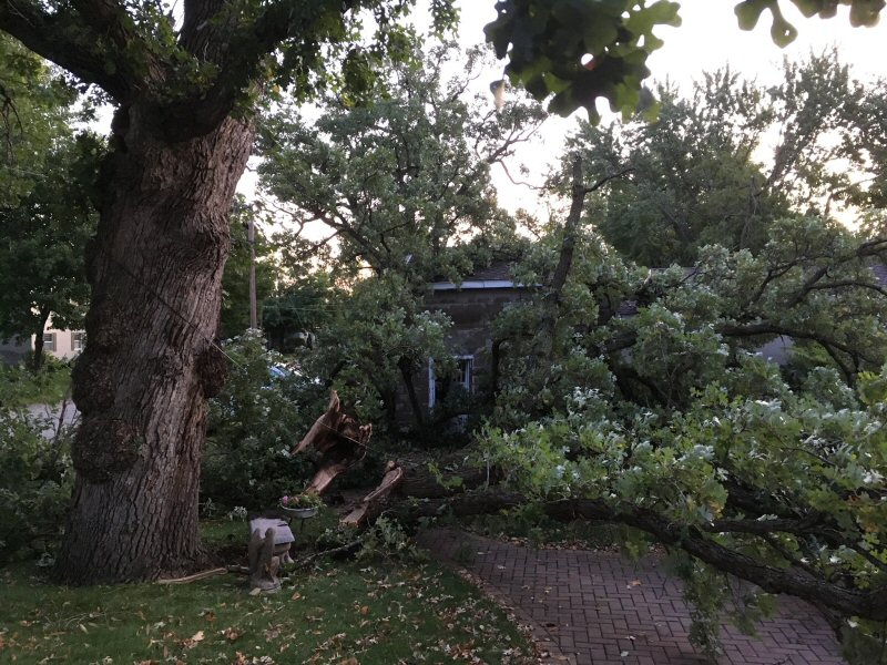
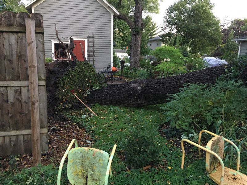
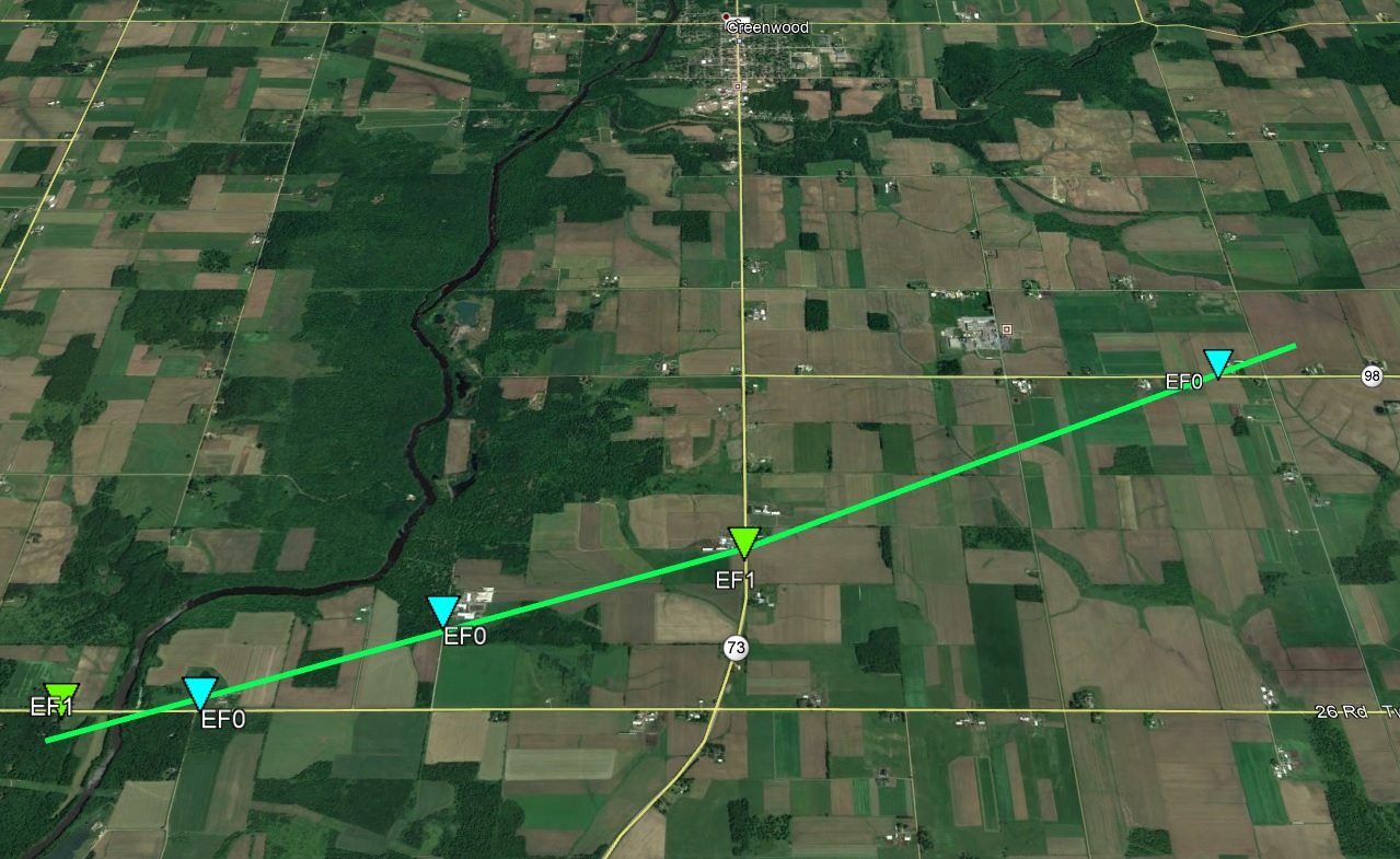
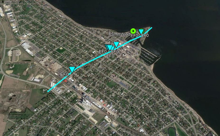
Tornado - Greenwood, WI
|
||||||||||||||||
 |
 |
 |
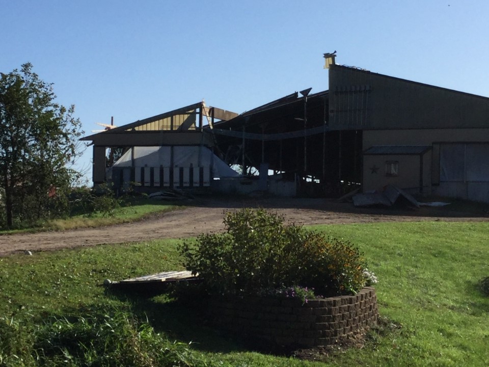 |
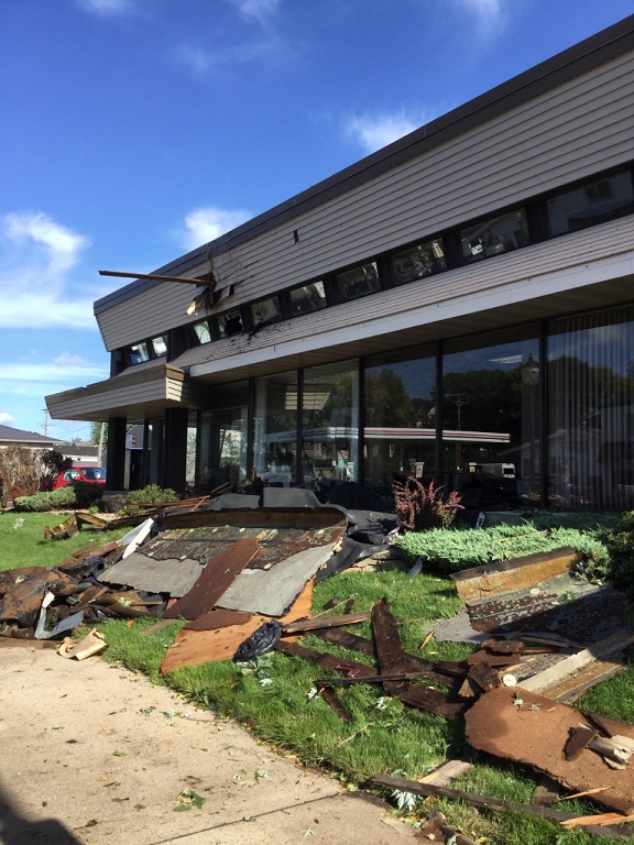
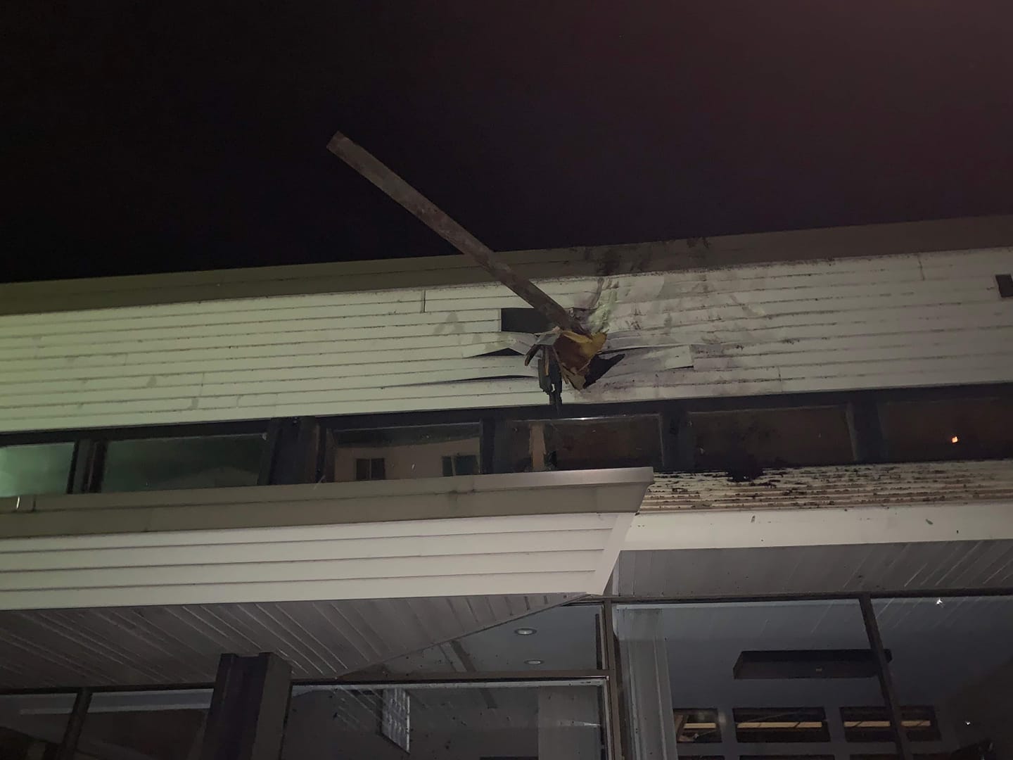
| Greenwood, WI NWS La Crosse Damage Survey |
Greenwood, WI NWS La Crosse Damage Survey |
Greenwood, WI NWS La Crosse Damage Survey |
Greenwood, WI NWS La Crosse Damage Survey |
|
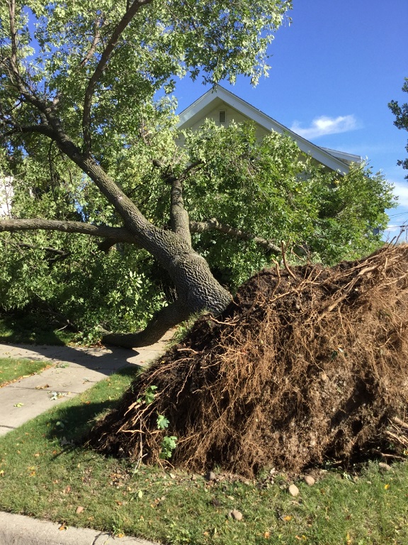
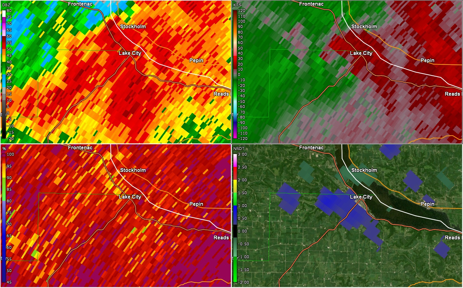
Tornado - Lake City, MN
|
||||||||||||||||
 |
 |
 |
 |
| Lake City, MN NWS La Crosse Damage Survey |
Lake City, MN NWS La Crosse Damage Survey |
Lake City, MN NWS La Crosse Damage Survey |
Lake City, MN NWS La Crosse Damage Survey |
The Enhanced Fujita (EF) Scale classifies tornadoes into the following categories:
| EF0 Weak 65-85 mph |
EF1 Moderate 86-110 mph |
EF2 Significant 111-135 mph |
EF3 Severe 136-165 mph |
EF4 Extreme 166-200 mph |
EF5 Catastrophic 200+ mph |
 |
|||||
Photos:
 |
 |
 |
 |
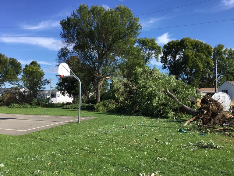
| Tree damage in Hammond, MN (Courtesy Tina Mann) |
Roof damage in Rochester (Courtesy John Howard-Carroll) |
Tree damage in Austin (Courtesy William Ingram) |
Tree damage in Austin (Courtesy William Ingram) |
 |
 |
 |
 |
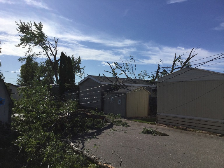
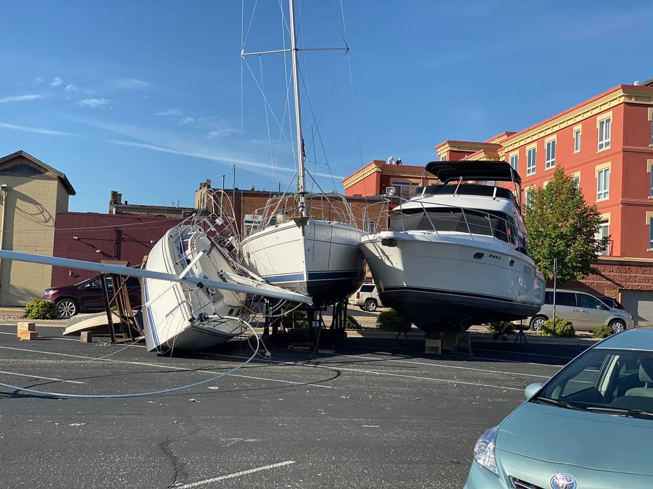
| Tornado damage in Lake City (Courtesy Mitchell Hawkins) |
Damage in Lake City (Courtesy Mitchell Hawkins) |
Tree damage in Lake City (Courtesy Jodee Glenna) |
Tree damage in Lake City (Courtesy Jodee Glenna) |
Storm Reports:
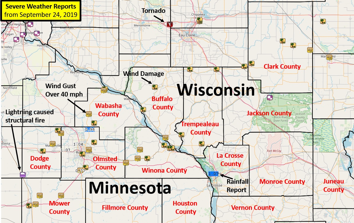 Local Storm Reports from September 24, 2019 |
PRELIMINARY LOCAL STORM REPORT...SUMMARY
NATIONAL WEATHER SERVICE LA CROSSE WI
538 AM CDT WED SEP 25 2019
..TIME... ...EVENT... ...CITY LOCATION... ...LAT.LON...
..DATE... ....MAG.... ..COUNTY LOCATION..ST.. ...SOURCE....
..REMARKS..
0739 PM TSTM WND GST 4 NW GENOA 44.15N 92.68W
09/24/2019 E55 MPH OLMSTED MN FIRE DEPT/RESCUE
0743 PM TSTM WND GST 1 N MANTORVILLE 44.08N 92.76W
09/24/2019 E50 MPH DODGE MN PUBLIC
0746 PM TSTM WND DMG DODGE CENTER 44.03N 92.85W
09/24/2019 DODGE MN LAW ENFORCEMENT
A TREE BLOWN DOWN.
0748 PM TSTM WND DMG LAKE CITY 44.45N 92.27W
09/24/2019 WABASHA MN PUBLIC
TREE AND POWER LINE DAMAGE. RELAYED VIA
BROADCAST MEDIA. TIME ESTIMATED FROM RADAR.
0754 PM TSTM WND GST LAKE CITY 44.44N 92.28W
09/24/2019 M55 MPH WABASHA MN AMATEUR RADIO
TREES AND BRANCHES DOWN ALONG HIGHWAY 63.
TIME ESTIMATED FROM RADAR.
0755 PM TSTM WND GST ZUMBRO FALLS 44.28N 92.42W
09/24/2019 E70 MPH WABASHA MN LAW ENFORCEMENT
POWER OUTAGES REPORTED.
0755 PM TSTM WND DMG 3 ENE BERNE 44.17N 92.71W
09/24/2019 DODGE MN PUBLIC
A TREE BLOWN DOWN.
0757 PM TSTM WND GST 3 E AUSTIN 43.67N 92.92W
09/24/2019 M60 MPH MOWER MN AWOS
AWOS STATION KAUM AUSTIN MUNICIPAL AIRPORT PEAK GUST
0758 PM TSTM WND GST ZUMBRO FALLS 44.28N 92.42W
09/24/2019 E80 MPH WABASHA MN PUBLIC
0759 PM LIGHTNING BLOOMING PRAIRIE 43.87N 93.04W
09/24/2019 DODGE MN LAW ENFORCEMENT
LIGHTNING STRIKE CAUSED STRUCTURE FIRE.
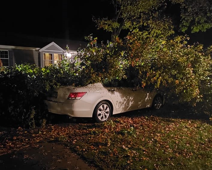
0800 PM TSTM WND DMG HAMMOND 44.22N 92.37W
09/24/2019 WABASHA MN PUBLIC
TREE DOWN ON CAR. RELAYED VIA BROADCAST
MEDIA. TIME ESTIMATED FROM RADAR.
0810 PM TSTM WND GST 3 NNW STEWARTVILLE 43.90N 92.50W
09/24/2019 M60 MPH OLMSTED MN ASOS
ASOS STATION KRST ROCHESTER INTERNATIONAL
AIRPORT.
0812 PM TSTM WND DMG 5 WSW MARION 43.92N 92.45W
09/24/2019 OLMSTED MN PUBLIC
TREES DOWN, PART OF A BARN ROOF PEELED OFF,
AND CALF HUTCHES TOSSED. RELAYED VIA
BROADCAST MEDIA. TIME ESTIMATED FROM RADAR.
0813 PM TSTM WND GST 3 NE ROCHESTER 44.04N 92.42W
09/24/2019 M41 MPH OLMSTED MN BROADCAST MEDIA
0815 PM TSTM WND DMG ROCHESTER 44.01N 92.48W
09/24/2019 OLMSTED MN PUBLIC
SEVERAL PHOTOS OF TREES DOWN THROUGHOUT
ROCHESTER. RELAYED VIA BROADCAST MEDIA. TIME
ESTIMATED FROM RADAR.
0820 PM TSTM WND DMG 5 WNW VIOLA 44.09N 92.37W
09/24/2019 OLMSTED MN PUBLIC
3 INCH DIAMETER TREE LIMB DOWN. PHOTO VIA
SOCIAL MEDIA.
0824 PM TSTM WND DMG 1 SSE ALMA 44.31N 91.91W
09/24/2019 BUFFALO WI PUBLIC
SEVERAL TREES BLOWN DOWN ALONG COUNTY RD E.
0829 PM TSTM WND DMG MODENA 44.46N 91.80W
09/24/2019 BUFFALO WI PUBLIC
SEVERAL TREES BLOWN DOWN IN TOWN.
0835 PM TSTM WND GST UTICA 43.98N 91.96W
09/24/2019 E60 MPH WINONA MN PUBLIC
ESTIMATED 50 TO 60 MPH.
0837 PM TSTM WND GST 1 S SAINT CHARLES 43.95N 92.07W
09/24/2019 E50 MPH WINONA MN TRAINED SPOTTER
ESTIMATED 50 MPH WINDS NEAR THE INTERSECTION
OF I-90 AND HWY 74.
0842 PM TSTM WND GST 2 NW BETHANY 44.04N 91.94W
09/24/2019 M55 MPH WINONA MN TRAINED SPOTTER
ESTIMATED 50 TO 55 MPH.
0847 PM TSTM WND DMG ELEVA 44.58N 91.47W
09/24/2019 TREMPEALEAU WI LAW ENFORCEMENT
TREES AND POWERLINES BLOWN DOWN.
0848 PM TSTM WND DMG LEWISTON 43.98N 91.87W
09/24/2019 WINONA MN PUBLIC
LARGE TREES DOWN. RELAYED VIA BROADCAST
MEDIA. TIME ESTIMATED FROM RADAR.
0850 PM TSTM WND GST FOUNTAIN CITY 44.12N 91.70W
09/24/2019 E55 MPH BUFFALO WI TRAINED SPOTTER
ESTIMATED 50 TO 60 MPH GUST.
0850 PM TSTM WND DMG 1 ENE WINONA 44.05N 91.64W
09/24/2019 WINONA MN PUBLIC
ROOF DAMAGE REPORTED AT SUBWAY.
0854 PM TSTM WND DMG WINONA 44.05N 91.66W
09/24/2019 WINONA MN EMERGENCY MNGR
NUMEROUS REPORTS OF TREES DOWN.
APPROXIMATELY 1200 HOMES WITHOUT POWER IN
WINONA, GOODVIEW, AND MINNESOTA CITY. TIME
ESTIMATED FROM RADAR.
0859 PM TSTM WND DMG GOODVIEW 44.07N 91.71W
09/24/2019 WINONA MN EMERGENCY MNGR
TREES DOWN AND BLOCKING ROAD. TREES ON FIRE
FROM POWER LINES.
0900 PM TSTM WND DMG OSSEO 44.58N 91.22W
09/24/2019 TREMPEALEAU WI LAW ENFORCEMENT
TREES AND POWERLINES BLOWN DOWN.
0900 PM TSTM WND DMG 1 E WINONA 44.05N 91.64W
09/24/2019 WINONA MN PUBLIC
TREE DAMAGE ON WINONA STATE UNIVERSITY
CAMPUS. PHOTOS VIA SOCIAL MEDIA. TIME
ESTIMATED FROM RADAR.
0910 PM TSTM WND DMG DODGE 44.14N 91.55W
09/24/2019 TREMPEALEAU WI LAW ENFORCEMENT
TREES AND POWERLINES BLOWN DOWN.
0911 PM TSTM WND DMG GALESVILLE 44.08N 91.36W
09/24/2019 TREMPEALEAU WI LAW ENFORCEMENT
TREES AND POWERLINES BLOWN DOWN.
0912 PM TSTM WND DMG 6 NW HUMBIRD 44.60N 90.96W
09/24/2019 JACKSON WI TRAINED SPOTTER
TREE UPROOTED AND DOWN ACROSS POWER LINE.
0914 PM TSTM WND GST WESTBORO 45.35N 90.30W
09/24/2019 M42 MPH TAYLOR WI PUBLIC
0915 PM TSTM WND DMG 6 N HUMBIRD 44.62N 90.89W
09/24/2019 CLARK WI LAW ENFORCEMENT
TREES AND POWER LINES BLOWN DOWN.
0918 PM HAIL 2 SE HATFIELD 44.39N 90.72W
09/24/2019 E0.25 INCH JACKSON WI PUBLIC
0927 PM TSTM WND DMG GREENWOOD 44.77N 90.60W
09/24/2019 CLARK WI LAW ENFORCEMENT
TREES AND POWER LINES BLOWN DOWN.
0929 PM TSTM WND DMG LOYAL 44.74N 90.50W
09/24/2019 CLARK WI LAW ENFORCEMENT
TREES AND POWER LINES BLOWN DOWN.
0943 PM TSTM WND GST 3 SW SPENCER 44.71N 90.34W
09/24/2019 E60 MPH CLARK WI TRAINED SPOTTER
0945 PM HEAVY RAIN 3 SSW HAMMOND 44.18N 92.41W
09/24/2019 M0.96 INCH OLMSTED MN MESONET
MESONET STATION EW7548 ROCHESTER.
0946 PM HEAVY RAIN 3 ESE DOUGLAS 44.08N 92.52W
09/24/2019 M1.04 INCH OLMSTED MN MESONET
MESONET STATION FW3896 ROCHESTER.
0946 PM HEAVY RAIN 1 NNE BYRON 44.04N 92.64W
09/24/2019 M1.07 INCH OLMSTED MN MESONET
MESONET STATION EW5820 BYRON.
1054 PM HEAVY RAIN 3 NNW STEWARTVILLE 43.90N 92.50W
09/24/2019 M0.77 INCH OLMSTED MN ASOS
ASOS STATION KRST ROCHESTER INTERNATIONAL
AIRPORT.
1101 PM HEAVY RAIN 2 NNE FRENCH ISLAND 43.88N 91.25W
09/24/2019 M1.07 INCH LA CROSSE WI ASOS
ASOS STATION KLSE LA CROSSE REGIONAL
AIRPORT.
Peak Wind Reports:
...HIGHEST WIND REPORTS...
Location Speed Time/Date Lat/Lon
...Iowa...
...Chickasaw County...
2 N Ionia 38 MPH 1020 PM 09/24 43.07N/92.46W
...Floyd County...
Charles City Airport 41 MPH 1015 PM 09/24 43.07N/92.62W
...Minnesota...
...Dodge County...
2 E Kasson 49 MPH 0735 PM 09/24 44.02N/92.71W
Dodge Center Airport 39 MPH 0756 PM 09/24 44.02N/92.82W
...Mower County...
1 ENE Dexter 65 MPH 0816 PM 09/24 43.73N/92.68W
Austin Municipal Airport 60 MPH 0757 PM 09/24 43.67N/92.92W
...Olmsted County...
Rochester International Airp 60 MPH 0810 PM 09/24 43.90N/92.50W
Jct CR 7 I-90 Mile Post 226 57 MPH 0920 PM 09/24 43.96N/92.21W
3 N Stewartville 50 MPH 0820 PM 09/24 43.90N/92.48W
Mayo Helipad 47 MPH 0816 PM 09/24 44.02N/92.48W
Rochester 39 MPH 0815 PM 09/24 44.09N/92.51W
Rochester 36 MPH 0810 PM 09/24 44.09N/92.49W
...Wabasha County...
Wabasha 47 MPH 0828 PM 09/24 44.30N/92.00W
Lake City 36 MPH 0815 PM 09/24 44.45N/92.27W
...Winona County...
1 E Ridgeway 51 MPH 1020 PM 09/24 43.91N/91.54W
Winona Municipal Airport 45 MPH 0855 PM 09/24 44.07N/91.70W
...Wisconsin...
...La Crosse County...
La Crosse Regional Airport 40 MPH 0756 PM 09/24 43.88N/91.25W
Observations are collected from a variety of sources with varying
equipment and exposures. We thank all volunteer weather observers
for their dedication. Not all data listed are considered official.
Radar:
 |
 |
 |
|
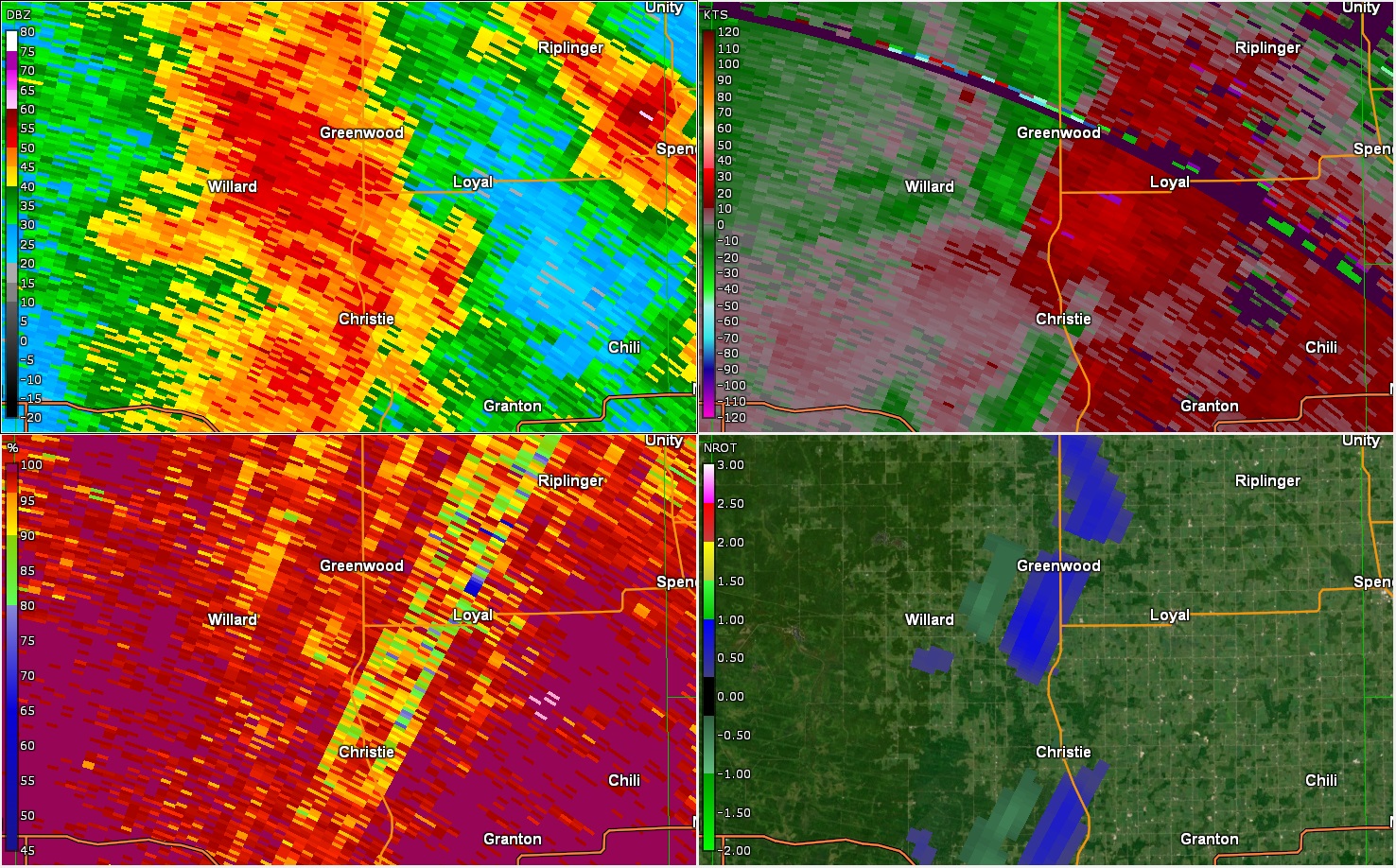
| Radar from 9:27 p.m. September 24, 2019 around the time Greenwood, WI tornado initially touched down. |
Radar from 7:58 p.m. September 24, 2019 around the time Lake City, MN tornado initially touched down. |
Caption | Caption |
Service:
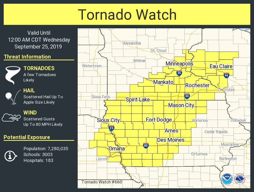
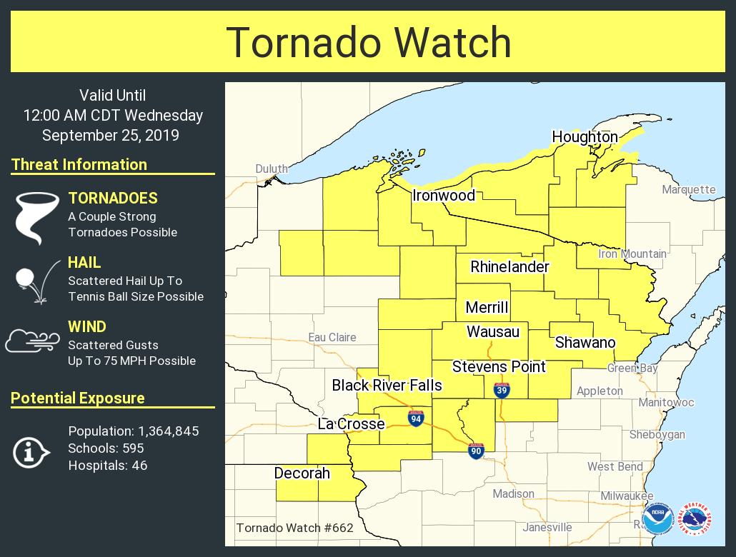
Watches
 |
 |
||
| Tornado Watch #660 | Tornado Watch #662 | Caption | Caption |
 |
Media use of NWS Web News Stories is encouraged! Please acknowledge the NWS as the source of any news information accessed from this site. |
|


 Weather Story
 Weather Map
 Local Radar