
Multiple chances exist for severe thunderstorms Monday. The 1st round will be Monday AM as thunderstorms travel SE from ND through MN and into our area. The second round will be Monday afternoon and evening as a cold front drops south across the area and thunderstorms develop. How the morning thunderstorms evolve, will dictate who & when will receive thunderstorms in the afternoon. Read More >
How Temperature Impacts Winter Precipitation Types
Ever wonder why sometimes there is freezing rain, freezing drizzle, or sleet in the winter? Why not just snow? What causes a wintry mix of preciptiation?
To better understand why this occurs, the interaction of warm air on precipitation and the depth of the cloud layer (i.e., the amount of moisture/saturation in the atmosphere) need to be examined.
When it comes to temperature, there are three basic considerations that will impact what type of precipitation will fall:
The depth of the cloud is a contributing factor to whether there will be a chance for accumulating precipitation (such as rain or snow) or lighter precipitation like drizzle. Generally, the deeper the cloud layer is, the better chance that a precipitation process can be initiated (in meteorology these processes are called the collision-coalescence process and the ice-crystal process [Bergeron-Findeisen process]). If the cloud layer is more shallow, typically it supports light precipitation in the form of drizzle or perhaps flurries - if any precipitation occurs at all.
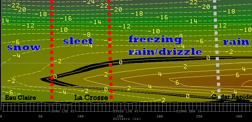
Below is a north to south (from left to right) running x-section of temperature from a mixed precipitation event that occurred on December 1, 2007. This example illustrates how the temperature a loft (not just at the surface) effects what type of precipitation will fall. Note the strong warm layer intruding from the south and how precipitation changed from rain, to freezing rain, to sleet and then snow depending on how far north the warm layer extended.


 Weather Story
 Weather Map
 Local Radar