NOAA's CPC Winter 2026-27 Outlook
for the Upper Mississippi River Valley
Released: Thursday, October 15, 2026
NOAA's Climate Prediction Center (CPC) forecast for the upcoming winter months of December 2026 through February 2027:
Winter 2026-27 Temperature Outlooks - Warmer than normal is favored (40-60% probabilities) across the Upper Mississippi River Valley.
|
 2026-27 CPC Driftless Region Winter (DJF) Temperature Outlook |
Winter 2026-27 Precipitation Outlook - Locally, there are equal chances that this winter will be drier, near, and wetter than normal.
|
 2026-27 CPC Driftless Region Winter (DJF) Precipitation Outlook |
Looking at the snow seasons during strong and very strong El Niños, these seasonal snow (July-June) were highly mixed with their totals. While most months are typically below average, there can be on a rare occasions some historically snowy months. Both La Crosse and Rochester have seen 4 months in the top 10 during strong and very strong El Niños.
For La Crosse, 7 out of 9 (77.8%) seasonal snows were below the 1991-2020 normal of 46.3”.
For Rochester, 7 out of 9 (77.8%) seasonal snows were below the 1991-2020 normal of 53.1”.
While a very strong (> 2°C for the seasonal average in Niño-3.4) El Niño is expected to impact the weather across much of the United States, its impacts in the Upper Mississippi River Valley can still be highly variable with precipitation. For more details on why these shifts were made, please see the local winter outlook tab below.
El Niño continues to strengthen, with a strong-to-very strong El Niño likely through January-March 2027 (remaining greater than an 83% chance).
El Niño strengthened further last month, with sea surface temperature anomalies exceeding +4.0°C in portions of the eastern equatorial Pacific [Fig. 1]. Most Niño indices increased in the past month, reaching +2.1°C in Niño-3.4, +3.0°C in Niño-3, and +3.9°C in Niño-1+2 [Fig. 2]. The equatorial subsurface temperature index (average from 180°-100°W) was well above average [Fig. 3], reflecting a deeper-than-average thermocline. Subsurface temperatures remained in excess of +10.0°C at depth in the eastern Pacific Ocean [Fig. 4]. Low-level westerly wind anomalies and upper-level easterly wind anomalies stretched from the western to the east-central equatorial Pacific. Enhanced convection and rainfall persisted from the central to the eastern Pacific, while anomalies remained suppressed over Indonesia [Fig. 5]. The traditional and equatorial Southern Oscillation indices were significantly negative. Collectively, the coupled ocean-atmosphere system reflected a strengthening El Niño.
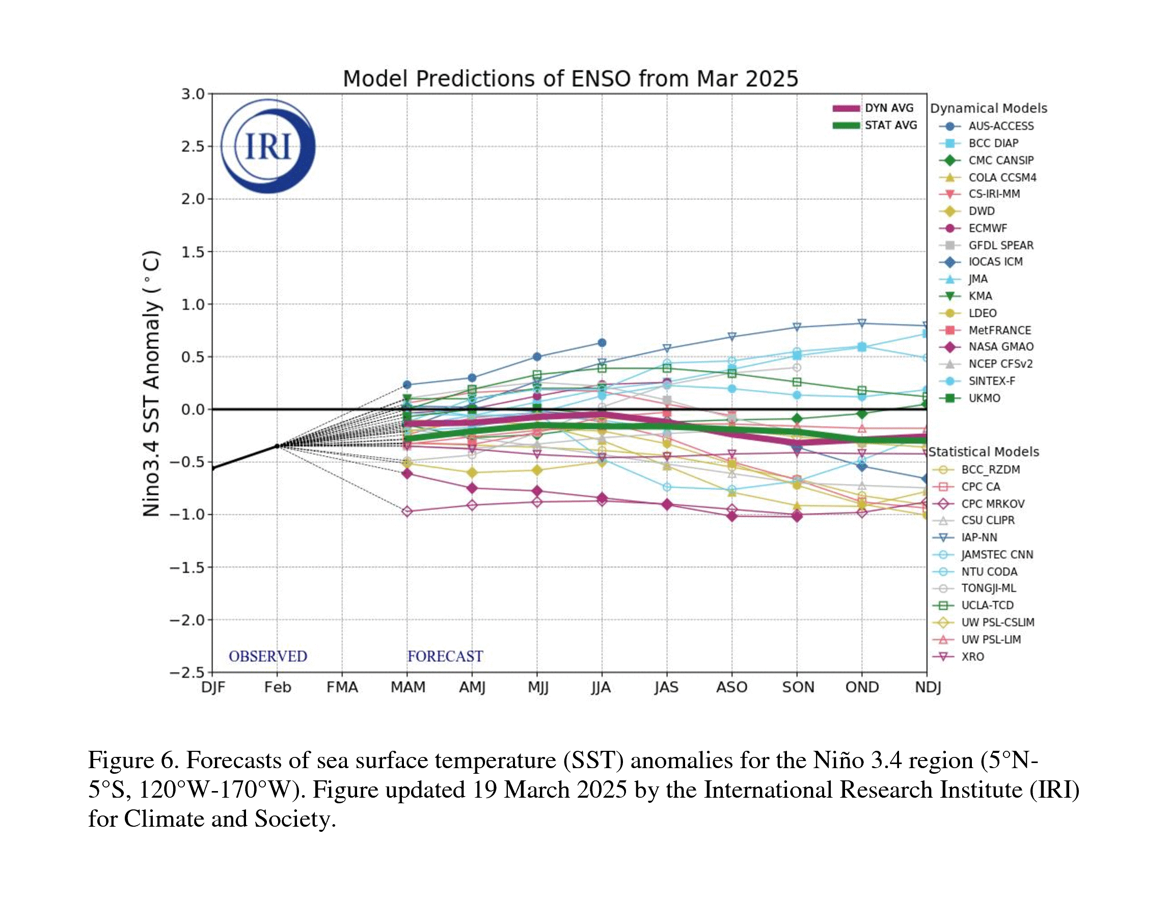
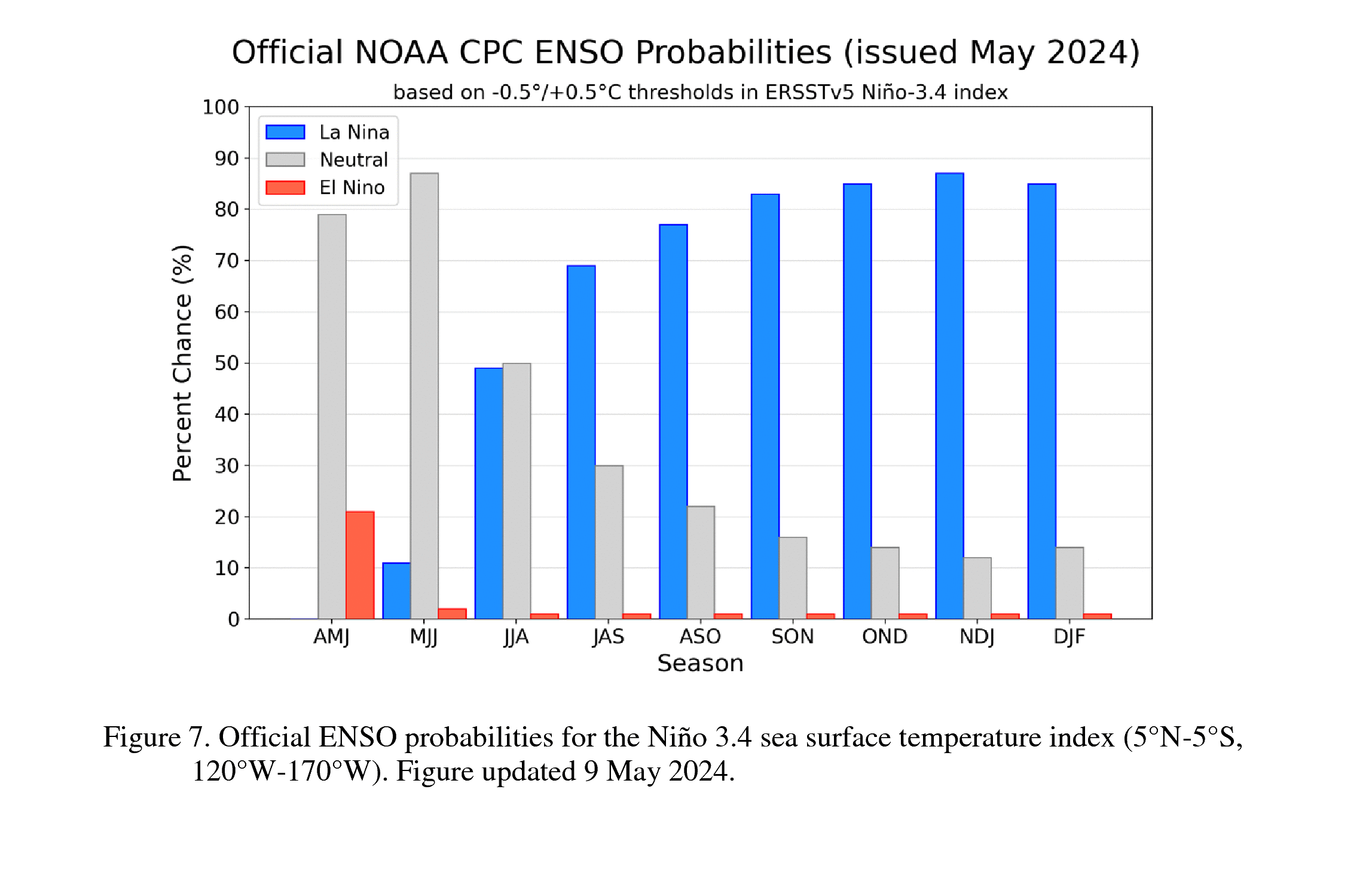
The CPC Official ENSO outlook, which synthesizes multiple models from North America and abroad, indicates El Niño will continue to strengthen through the end of the year [Figs. 6-7-8]. Chances remain high for a historic event that would exceed the strength of previous El Niño events dating back to 1950 (+2.5°C or more for a 3-month RONI value): the chance is 54% for September-November, 83% for October-December, and 70% for November-January. With an event of this magnitude, the chances of experiencing impacts consistent with El Niño are larger, though not guaranteed (see CPC outlooks for probabilities of seasonal anomalies). In summary, El Niño continues to strengthen, with a strong-to-very strong El Niño likely through January-March 2027 (remaining greater than an 83% chance).
This discussion is a consolidated effort of the National Oceanic and Atmospheric Administration (NOAA), NOAA's National Weather Service, and their funded institutions. Oceanic and atmospheric conditions are updated weekly on the Climate Prediction Center web site (El Niño/La Niña Current Conditions and Expert Discussions). A probabilistic strength forecast is available here. The next ENSO Diagnostics Discussion is scheduled for 12 November 2026.
This will be the first El Niño since 2023-24. That one was moderate (1 - 1.4°C for the seasonal average in Niño-3.4). The last very strong El Niño (> 2°C for the seasonal average in Niño-3.4) was 2015-16.
Besides El Niño, this winter will also be affected by:
CPC 2026-27 U.S. Winter Outlook:
The CPC winter temperature forecasts to the right show the most likely outcome where there is greater confidence, but this is not the only possible outcome. Equal chance display areas where confidence is low, so there is an equal chance of it being among the warmest third, near-normal, or among the coldest third. |
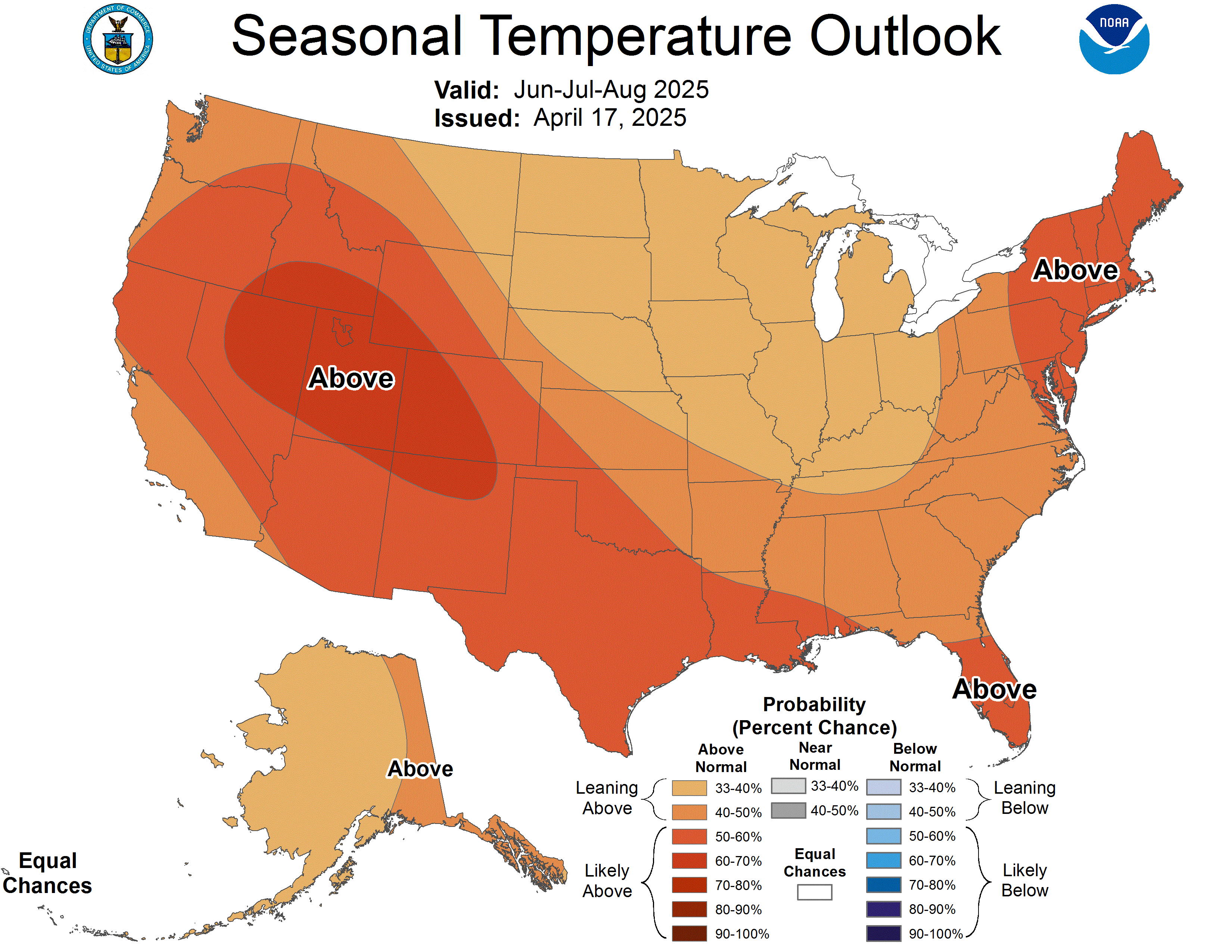 CPC's Winter 2026-27 U. S. Temperature Outlook |
The CPC winter forecasts to the right show the most likely outcome where there is greater confidence, but this is not the only possible outcome. Equal chance display areas where confidence is low, so there is an equal chance of it being among the wettest third, near-normal, or among the driest third. |
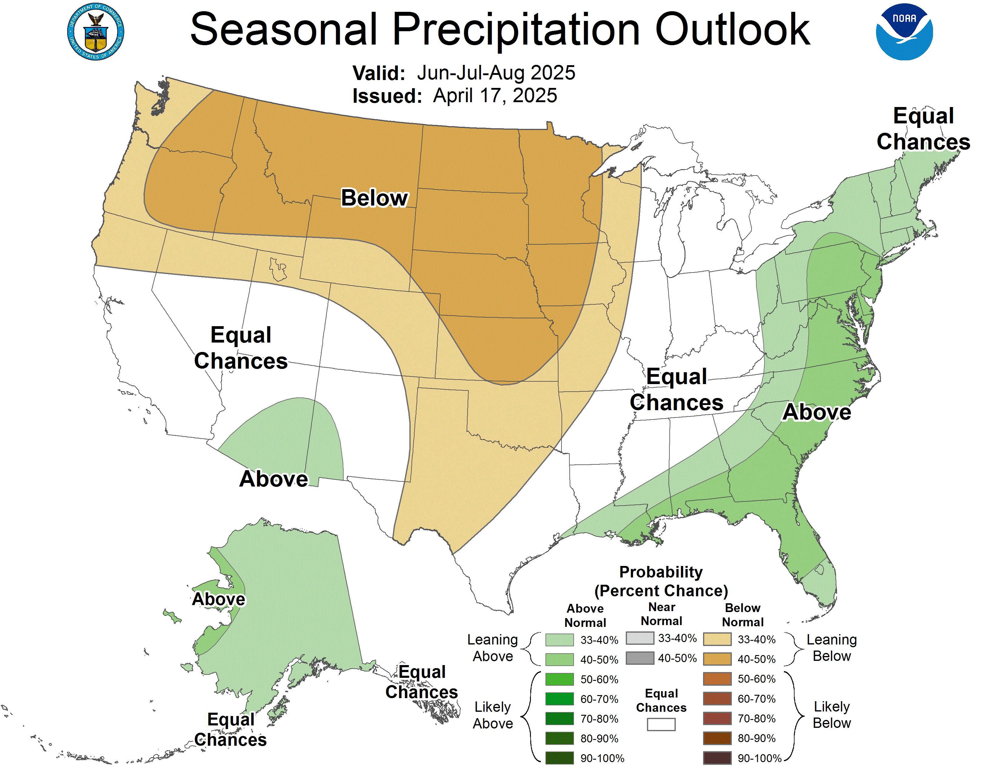 CPC's Winter 2026-27 U. S. Precipitation Outlook |
|
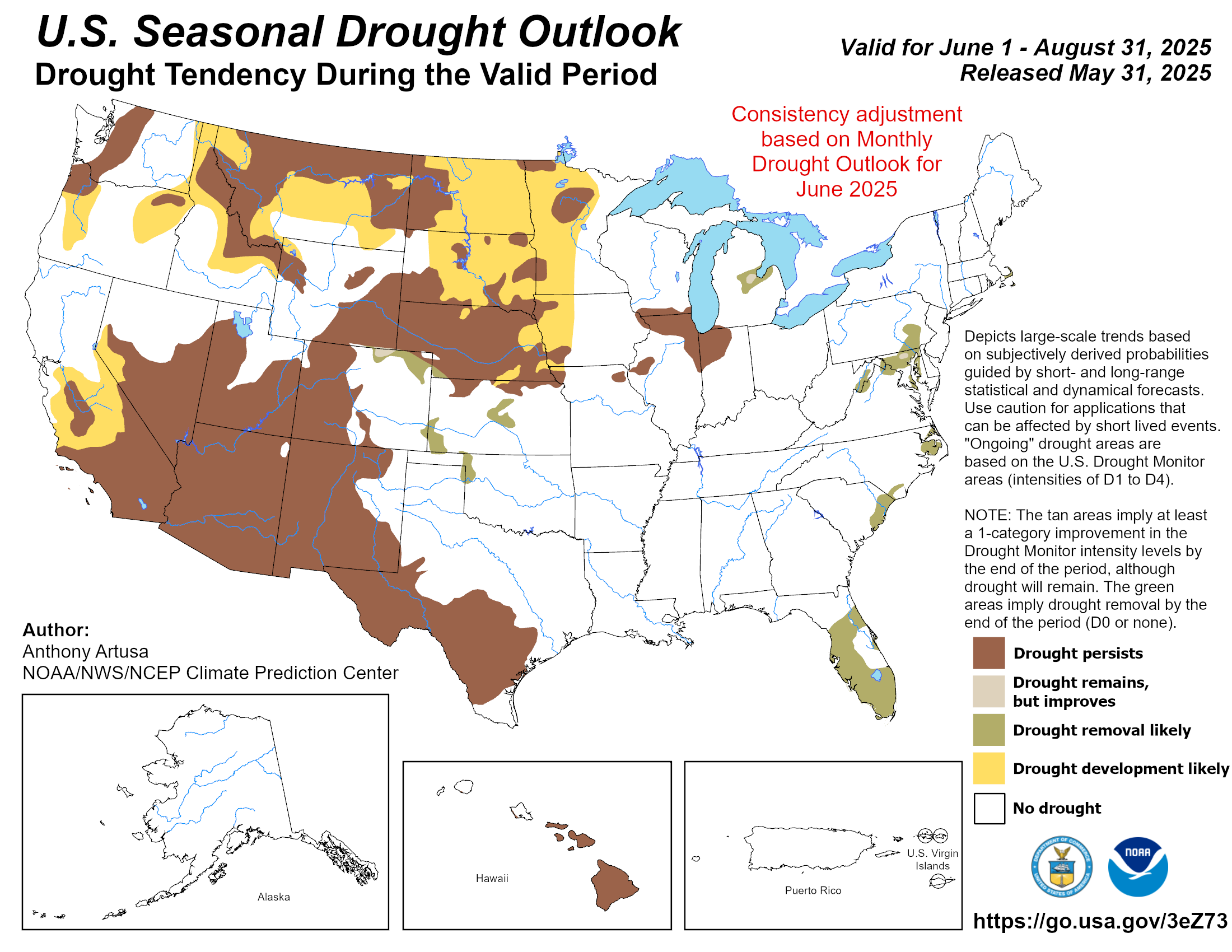 CPC's Winter 2026-27 U. S. Drought Outlook |
Local Winter Outlook:
Locally, the odds have been tilted toward warmer-than-normal (not just a tenth of a degree warmer than normal, but among the warmest third of the winters from 1991-2020) in northeast Iowa, southeast Minnesota, and western Wisconsin. The probabilities were shifted to 40 to 60%.
Why warmer-than-normal?
Since 1949-50, a majority of strong & very strong El Niños winters were among the warmest third of all winters.
For La Crosse, 18 out of 27 winter months (66.7%) and 5 out of 9 winters (55.6%) were among the warmest third. This includes the 5th and 9th warmest winters. In addition, the 2 warmest winters (1877-78 & 2023-24) were El Niño winters.
For Rochester, 17 out of 27 winter months (62.9%) and 6 out of 9 winters (66.7%) were among the warmest third. This includes the 5th-9th warmest winters. In addition, the warmest winter (2023-24) was a moderate El Niño winter.
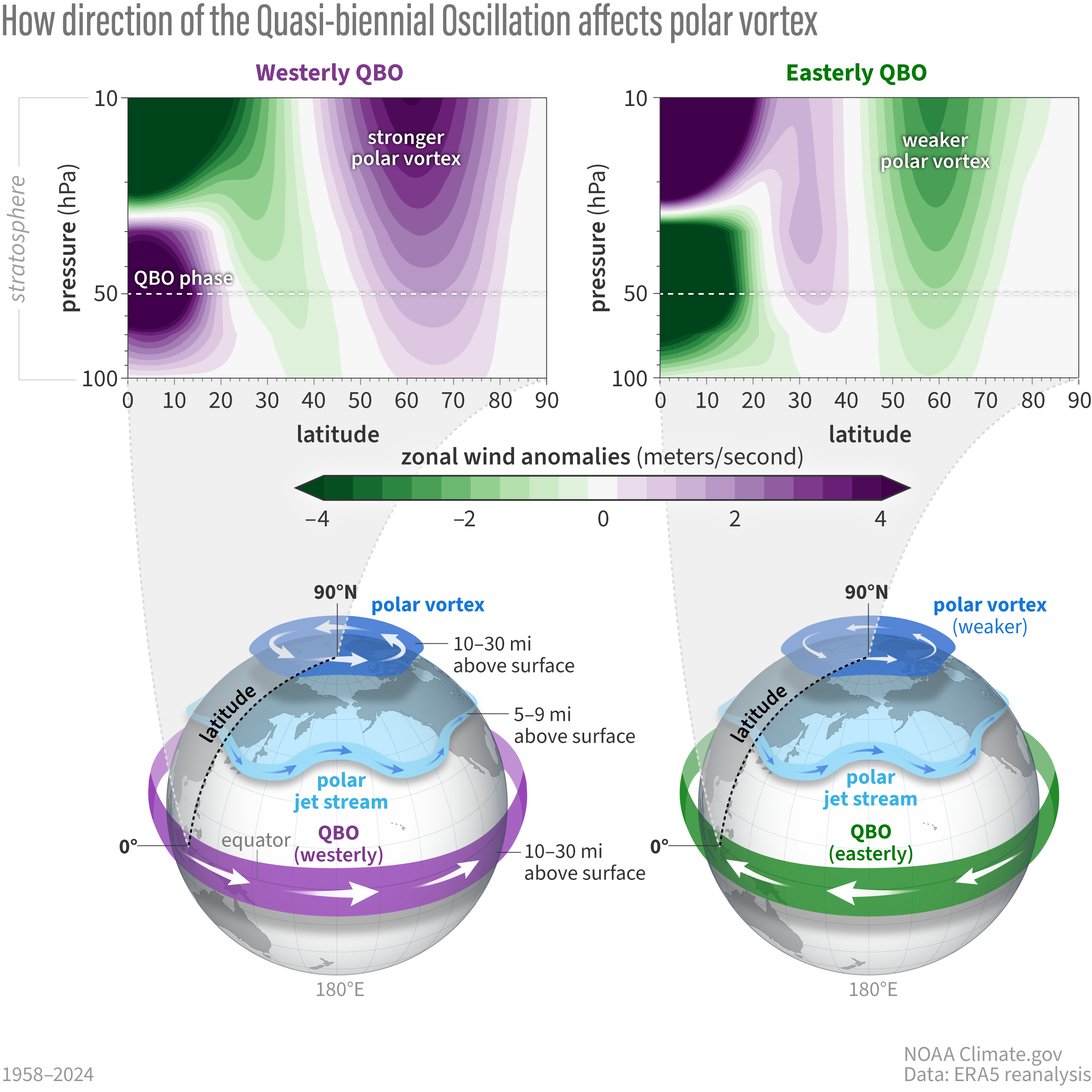
The Quasi-biennial Oscillation (QBO) will be from the west this winter (Dec-Jan). This results in the polar stratospheric winds being stronger than average (purple). This makes sudden stratospheric warming less likely to occur; thus, less Arctic Outbreaks.
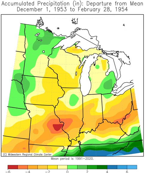
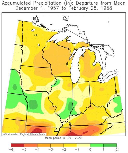
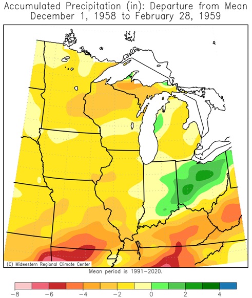
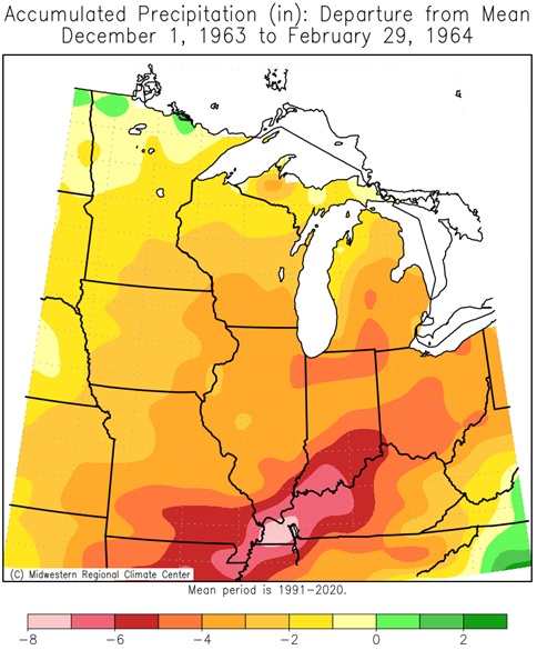
Locally, there are equal chances that this winter will be drier, near, and wetter than normal.
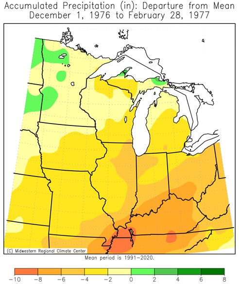
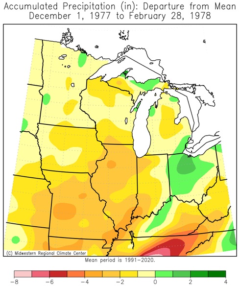
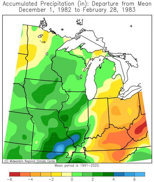
Since 1949-50, a majority of strong & very strong El Niños winters were among the wettest third of winters.
For La Crosse, 13 out of 27 winter months (48.1%) and 6 out of 9 winters (66.7%) were among the wettest third. This includes the wettest winter month (Dec 2015) & wettest winter (2015-16).
For Rochester, 20 out of 27 winter months (74%) and 6 out of 9 winters (66.7%) were among the wettest third. This includes the 6th and 8th wettest winters. In contrast, these winters also included the driest winter (1957-58).
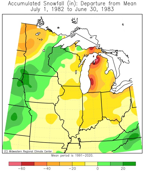
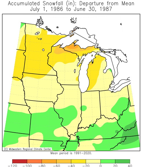
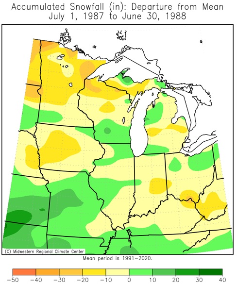
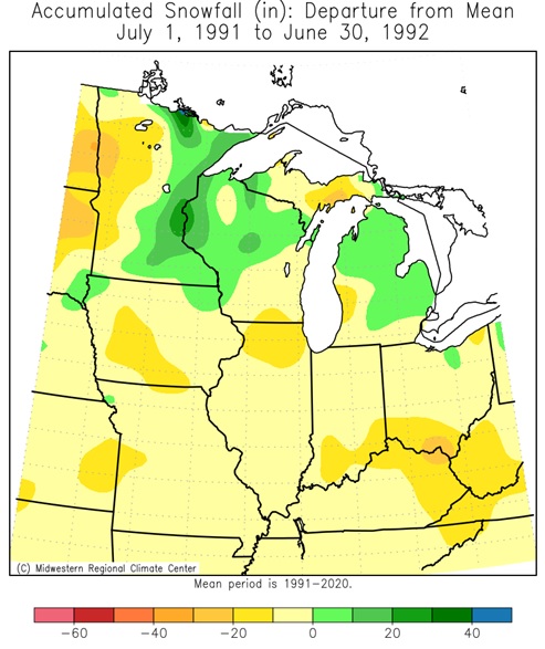
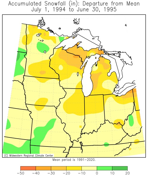
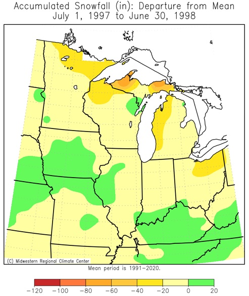
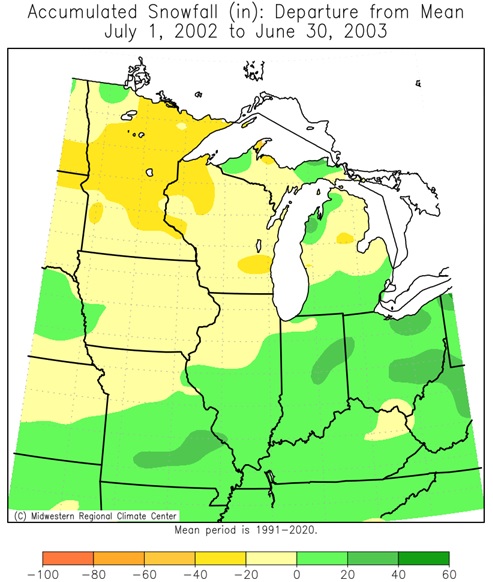
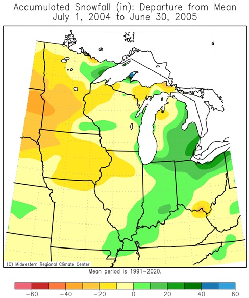
Seasonal snow has been generally near to below normal during the 9 strong and very strong El Niños since 1949-50.
Looking at the snow seasons during strong and very strong El Niños, these seasonal snow (July-June) were highly mixed with their totals. While most months are typically below average, there can be on a rare occasions some historically snowy months. Both La Crosse and Rochester have seen 4 months in the top 10 during strong and very strong El Niños.
For La Crosse, 7 out of 9 (77.8%) seasonal snows were below the 1991-2020 normal of 46.3”.
For Rochester, 7 out of 9 (77.8%) seasonal snows were below the 1991-2020 normal of 53.1”.
Snowstorms will occur at times this winter. However, the frequency, number, and intensity of these events cannot be predicted on a seasonal timescale.
What is El Niño?:
What is El Niño?
El Niño literally means "the little boy." in Spanish. South American fishermen first noticed periods of unusually warm water in the Pacific Ocean in the 1600s. The full name they used was El Niño de Navidad, because El Niño typically peaks around December. El Niño is sometimes referred to as simply "a warm event" or "a warm episode". El Niño refers to abnormally warm water temperatures across the central and eastern equatorial waters (5°N-5°S, 120°-170
During El Niño, trade winds weaken. Warm water is pushed back east, toward the west coast of the Americas.
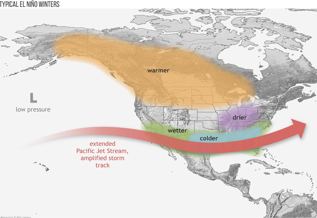
El Niño can affect our weather significantly. The warmer waters cause the Pacific jet stream to move south of its neutral position. With this shift, areas in the northern U.S. and Canada are dryer and warmer than usual. But in the U.S. Gulf Coast and Southeast, these periods are wetter than usual and have increased flooding.
El Niño also has a strong effect on marine life off the Pacific coast. During normal conditions, upwelling brings water from the depths to the surface; this water is cold and nutrient-rich. During El Niño, upwelling weakens or stops altogether. Without the nutrients from the deep, there are fewer phytoplankton off the coast. This affects fish that eat phytoplankton and, in turn, affects everything that eats fish. The warmer waters can also bring tropical species, like yellowtail and albacore tuna, into areas that are normally too cold.
During El Niño, the warm pool of water usually in the western Pacific Ocean begins to slosh to the east. As this warm pool moves east, the rising branch of the Pacific cell of the Walker Circulation follows, and the rest of the Walker Circulation gets shifted around. Instead of a strong rising motion over the Maritime Continent, upward flow weakens, and anomalous sinking motion occurs. The usual rising, moist air over South America is replaced by another anomalous sinking branch. The reversal of the circulation generally means that less rainfall than average dominates in these two areas during El Niño. In contrast, increased rising motion enhances rainfall over the central Pacific Ocean and even parts of equatorial eastern Africa.
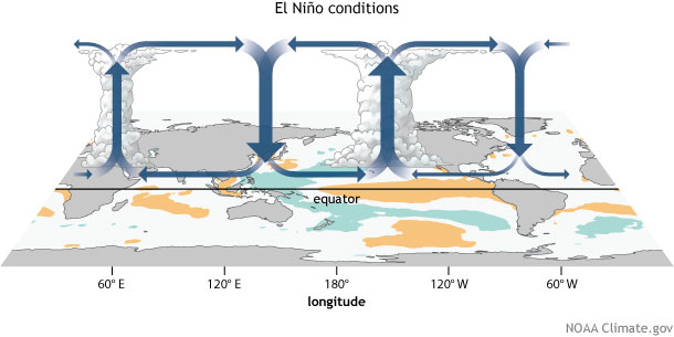 |
Generalized Walker Circulation (December-February) anomaly during El Niño events, overlaid on a map of average sea surface temperature anomalies. Anomalous ocean warming in the central and eastern Pacific (orange) helps to shift a rising branch of the Walker Circulation to the east of 180° longitude, while sinking branches shift to over the Maritime continent and northern South America. NOAA Climate.gov drawing by Fiona Martin.
El Niño episodes typically last 9-12 months. They both tend to develop during the spring (March-June), reach peak intensity during the late autumn or winter (November-February), and then weaken during the spring or early summer (March-June). The longest El Niño lasted 16 consecutive 3-month seasons from Autumn 2014 (September through November) into the Spring of 2016 (March through May). Generally, El Niño occurs more frequently than La Niña.
During El Niño winters (December through February), warmer-than-normal temperatures are typically found across western and central Canada, from India east into the Maritime continent, Japan, southeast Australia, and parts of eastern Brazil. Colder-than-normal temperatures are typically found across the southern U.S. and parts of northern Mexico. Wetter-than-normal conditions are typically seen across the southern U.S., northern Mexico, southern parts of South America, along the equator from east of the Maritime continent east to South America, southeast China, and east-central Africa. Drier-than-normal conditions are typically seen from Hawaii west to the Maritime continent and then southeast through northern Australia to Fiji and French Polynesia, and southern Africa.
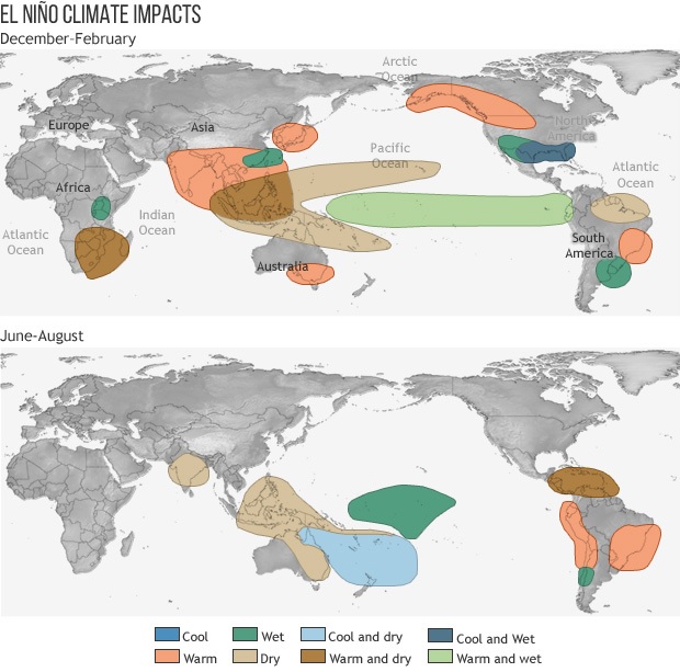 |
There has been a fair amount of variability in the winter temperature and precipitation patterns during El Niño, but also that there are some clear tendencies for above or below-normal temperature or precipitation in some regions.
 |
El Niño Winter Temperatures
Author: Rebecca Lindsey (October 24, 2018)
|
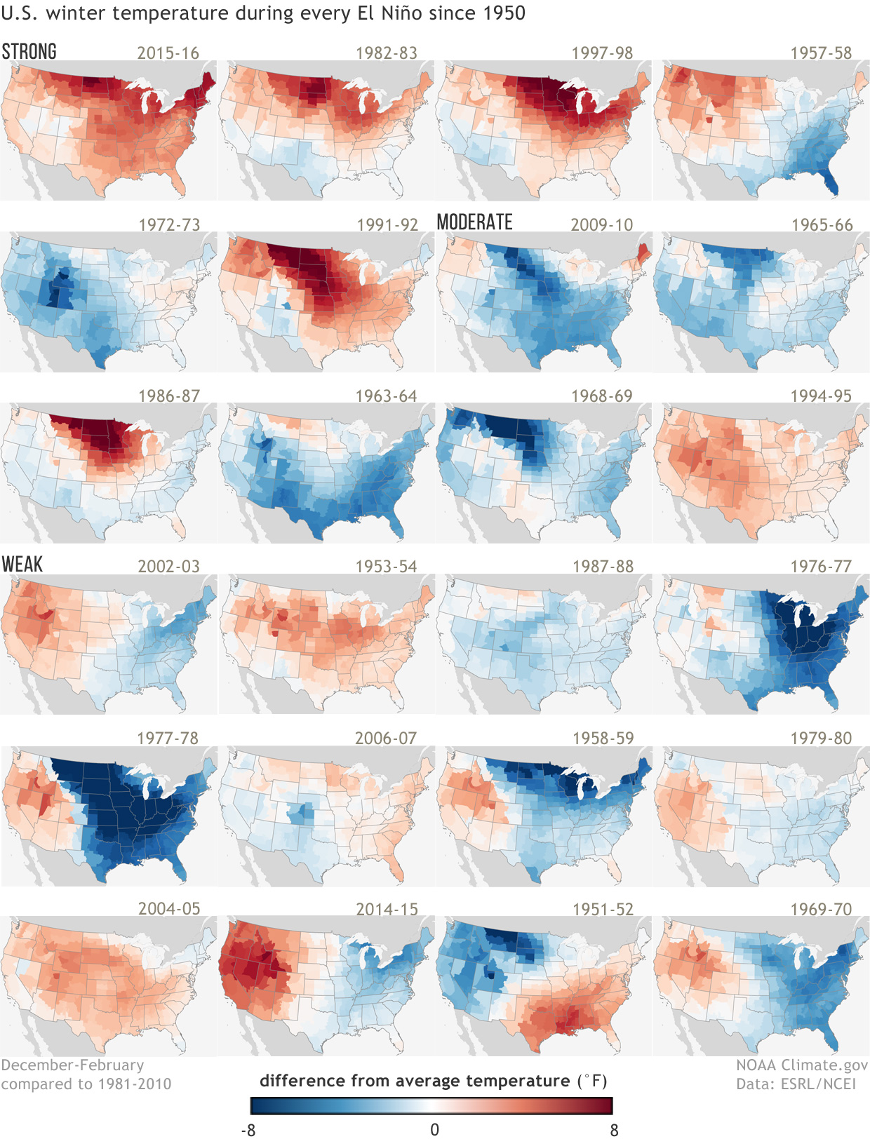
The collection of maps at right shows the difference in average (1981-2010) winter temperature (December-February) in each U.S. climate division during all El Niño events since 1950. Years are ranked from strongest El Niño (top left) to weakest (bottom right)‚ based on the December–February Oceanic Niño Index value. There is no universal way to define the strength of El Niño events, but for this graphic, events with ONI values above 1.5 are ranked as strong, events with ONI values between 1 and 1.5 are ranked as moderate, and events with ONI values between 0.5 and 1 are ranked as weak. These maps were first published on NOAA's ENSO blog as part of the 2015-16 winter outlook post by Mike Halpert, Deputy Director of NOAA's Climate Prediction Center. They were updated for Halpert's post about the 2018-19 winter outlook. In the original post, Halpert pointed out that compared to precipitation, temperature patterns are much less consistent, even during the strongest events. Four of the six strong events have a warm signal that is nearly nationwide, but even among them, the geographic details—the location of the biggest anomalies, where the few cool spots are—vary from one event to another. Looking at both strong and moderate events, the patterns become even less consistent. Eight of the twelve events have a warm signal in the Northern Plains (a much smaller area than is affected in the strong events), but 4 are colder than normal. This variability from one El Niño to the next is one reason why CPC scientists always talk about seasonal climate outlooks in terms of "odds," "chances," or "probabilities"—not guarantees. Maps by NOAA Climate.gov, based on NCDC climate division data provided by the Physical Sciences Division at NOAA ESRL. |
Winter (December-February) temperature during strong, moderate, and weak La Niñas since 1950 (Winter 2017-18 not included) |
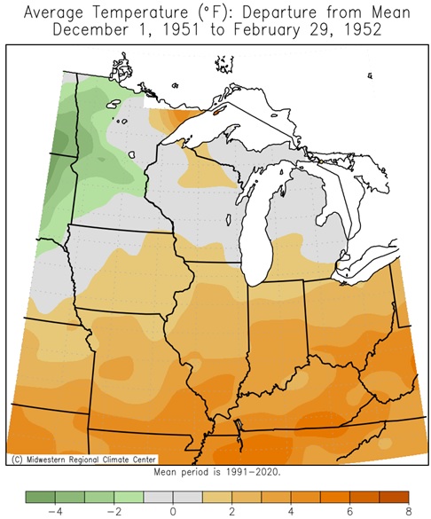
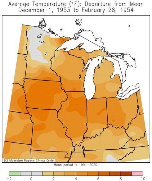
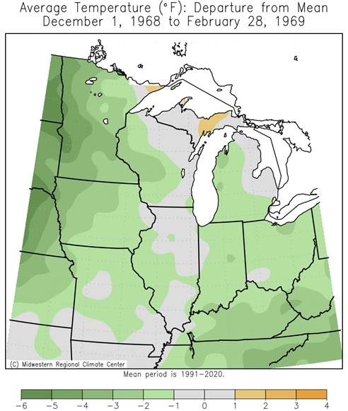
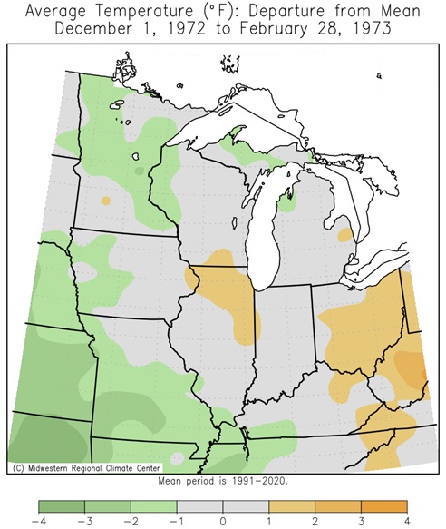
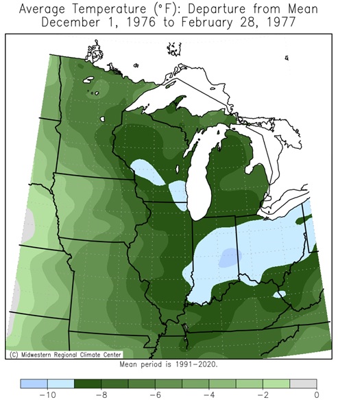
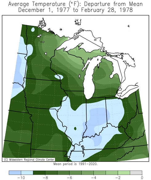
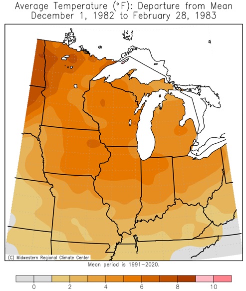
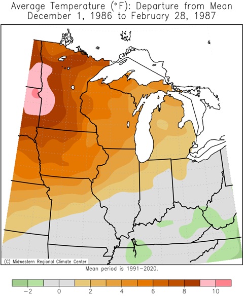
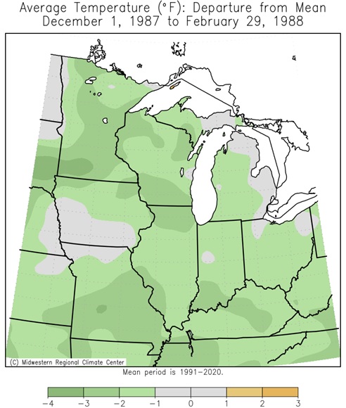
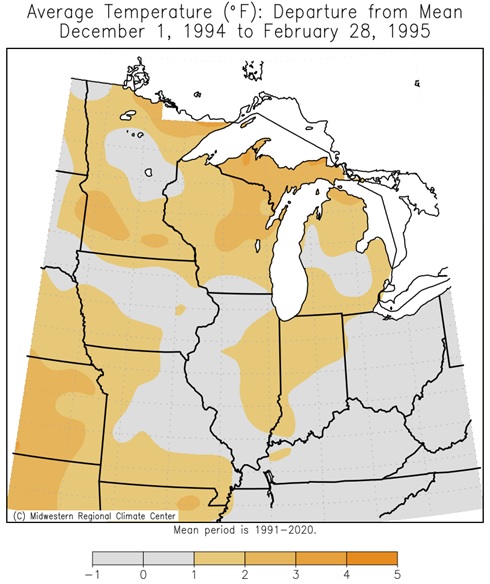
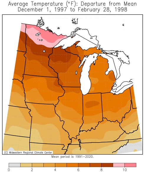
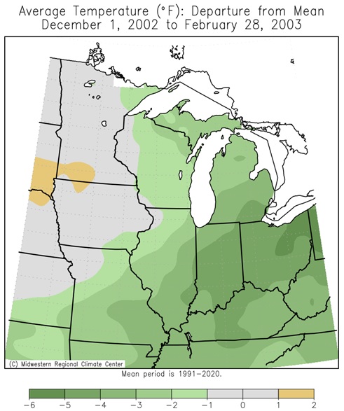
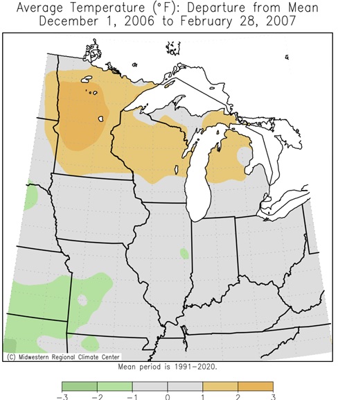
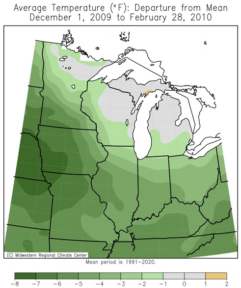
Midwest El Niño Winter (DJF) Average Temperature Departures (26 Winters since 1949-50)
 |
 |
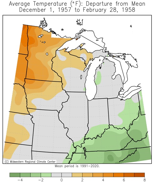 |
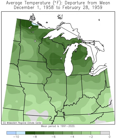 |
| 1951-1952 | 1953-1954 | 1957-1958 | 1958-1959 |
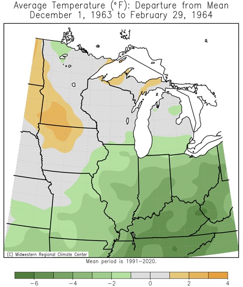 |
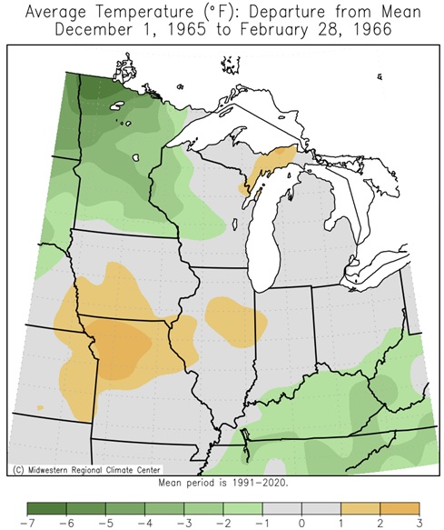 |
 |
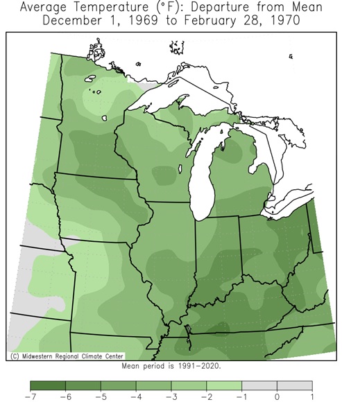 |
| 1963-1964 | 1965-1966 | 1968-1969 | 1969-1970 |
 |
 |
 |
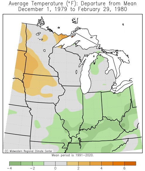 |
| 1972-1973 | 1976-1977 | 1977-1978 | 1979-1980 |
 |
 |
 |
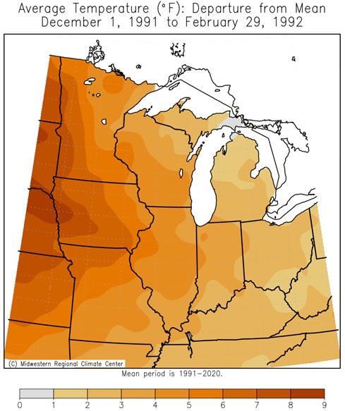 |
| 1982-1983 | 1986-1987 | 1987-1988 | 1991-1992 |
 |
 |
 |
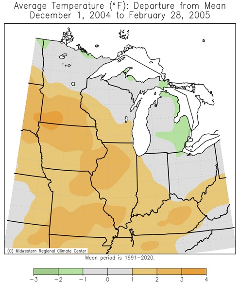 |
| 1994-1995 | 1997-1998 | 2002-2003 | 2004-2005 |
 |
 |
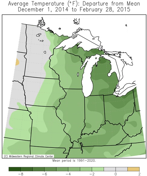 |
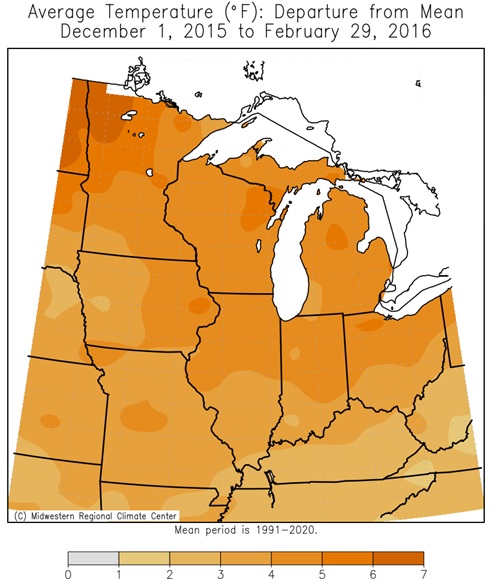 |
| 2006-2007 | 2009-2010 | 2014-2015 | 2015-2016 |
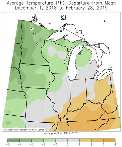 |
 |
||
| 2018-2019 | 2023-2024 |
El Niño Winter Precipitation
Author: Rebecca Lindsey (October 24, 2018)
|
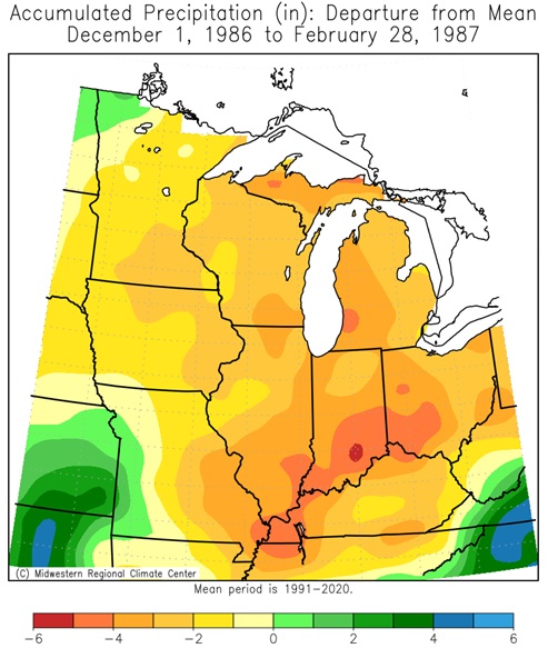
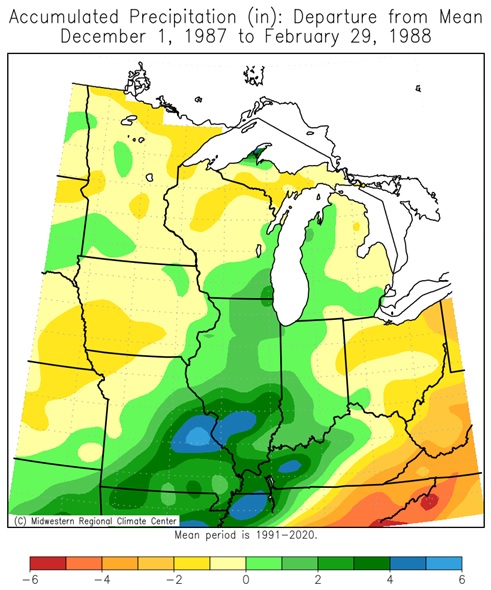
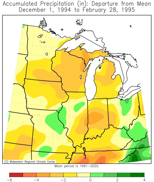
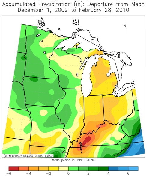
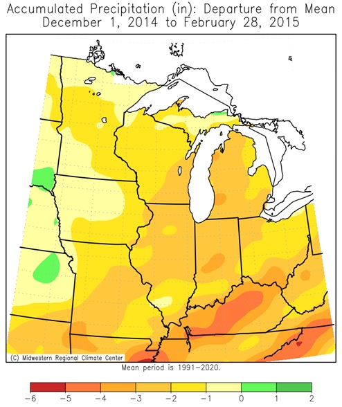
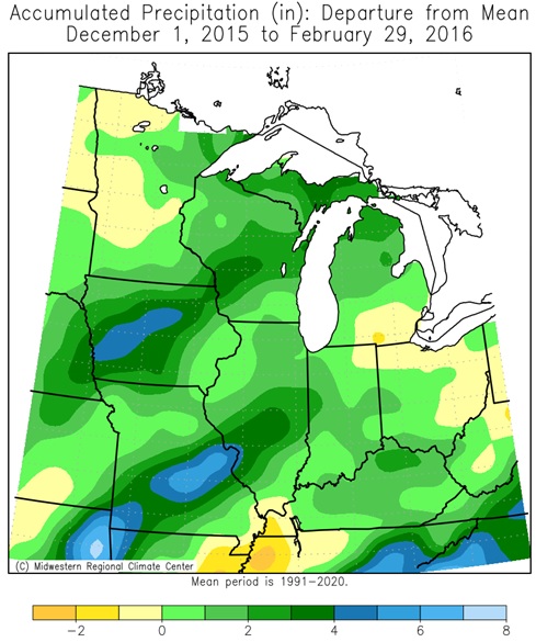
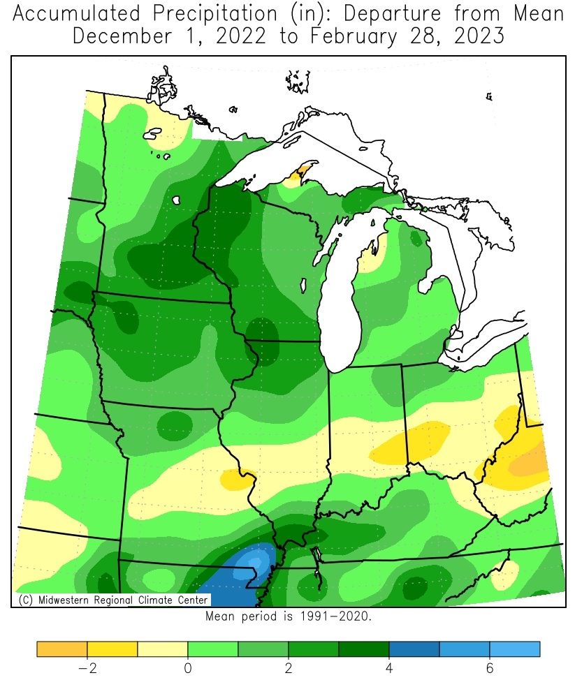
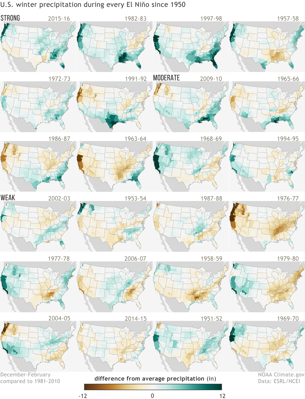
The collection of maps at right shows winter precipitation (December-February) in each U.S. climate division compared to the 1981-2010 average during all 24 El Niño events since 1950. Years are ranked from strongest El Niño (top left) to weakest (bottom right)‚ based on the Oceanic Niño Index value observed during December–February. There is no universal definition for ranking the strength of ENSO events; for this graphic, events with ONI values greater than 1.5 were ranked as strong, events with ONI values between 1 and 1.5 were ranked as moderate, and events with ONI values less than 1 were ranked as weak. These maps were first published on our ENSO blog as part of the 2015-16 winter outlook post by Mike Halpert, Deputy Director of NOAA's Climate Prediction Center. They were updated for Halpert's post about the 2018-19 winter outlook. In the original post, Halpert wrote,
This variability from one El Niño to the next is one reason why CPC scientists always talk about seasonal climate outlooks in terms of "odds," "chances," or "probabilities"—not guarantees. For example, the climate division in the southernmost tip of Florida experienced wetter-than-average winters in 5 out of 6 strong El Niño events, and in 10 of 12 strong and moderate events, which is a high percentage, but still not a guarantee. And the magnitude of the anomaly—how much wetter than average—varied from just barely above average to much wetter than average. This “failure” of the typical pattern occurs because El Niño is never the only thing that influences the climate of the United States during the winter. Other climate phenomena, such as the Arctic Oscillation or the Madden-Julian Oscillation, as well as the random nature of weather, can also play a large part in how winter turns out. Maps by NOAA Climate.gov, based on NCDC climate division data provided by the Physical Sciences Division at NOAA ESRL. |
Winter (December-February) precipitation during strong, moderate, and weak La Niñas since 1950 (Winter 2017-18 not included) |
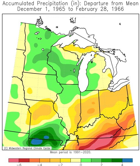
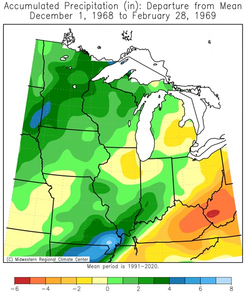
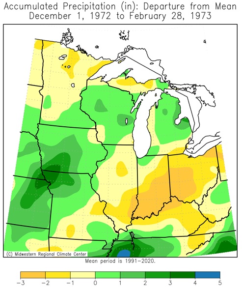
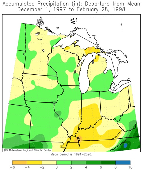
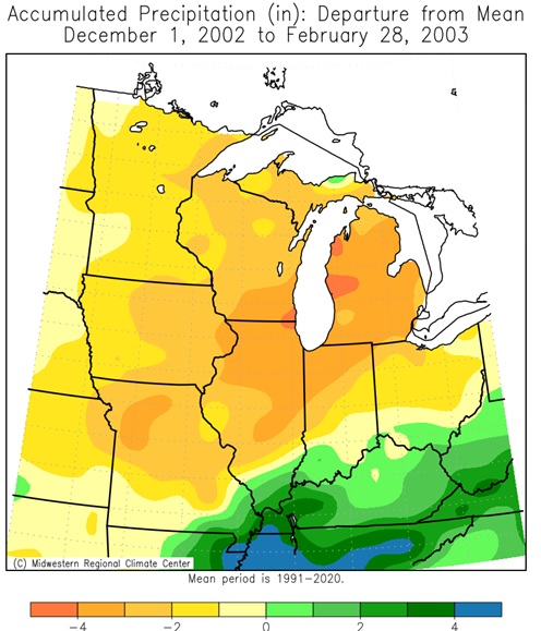
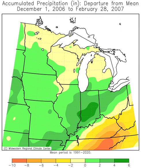
Midwest El Niño Winter Winter (DJF) Precipitation Departures (26 Winters since 1949-50)
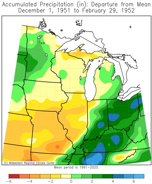 |
 |
 |
 |
| 1951-1952 | 1953-1954 | 1957-1958 | 1958-1959 |
 |
 |
 |
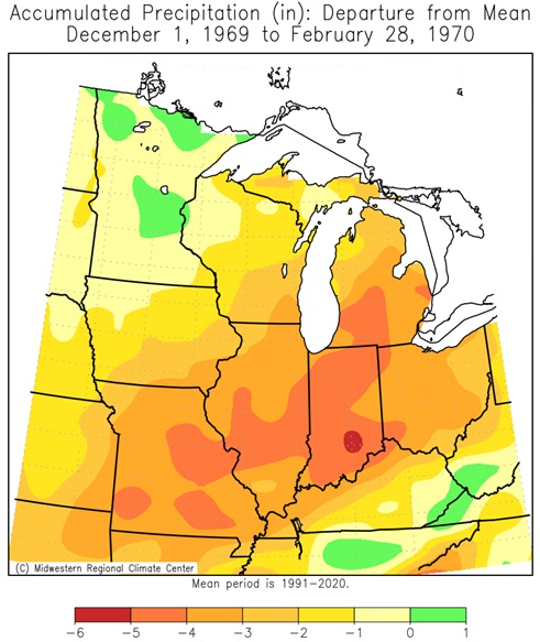 |
| 1963-1964 | 1965-1966 | 1968-1969 | 1969-1970 |
 |
 |
 |
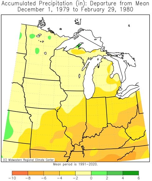 |
| 1972-1973 | 1976-1977 | 1977-1978 | 1979-1980 |
 |
 |
 |
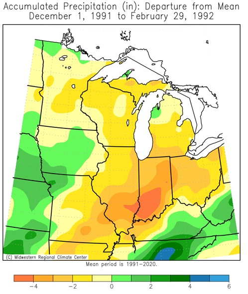 |
| 1982-1983 | 1986-1987 | 1987-1988 | 1991-1992 |
 |
 |
 |
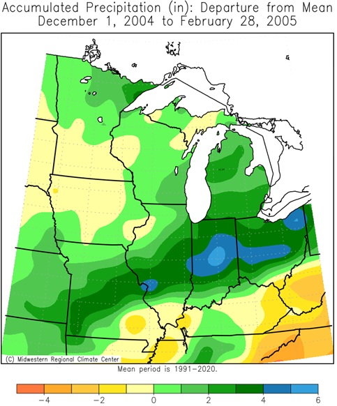 |
| 1994-1995 | 1997-1998 | 2002-2003 | 2004-2005 |
 |
 |
 |
 |
| 2006-2007 | 2009-2010 | 2014-2015 | 2015-2016 |
 |
 |
||
| 2018-2019 | 2023-2024 |
El Niño Seasonal Snow
| Authors: Michelle L'Heureux & Brian Brettsheider (October 26, 2023) | ||
|
 |
|
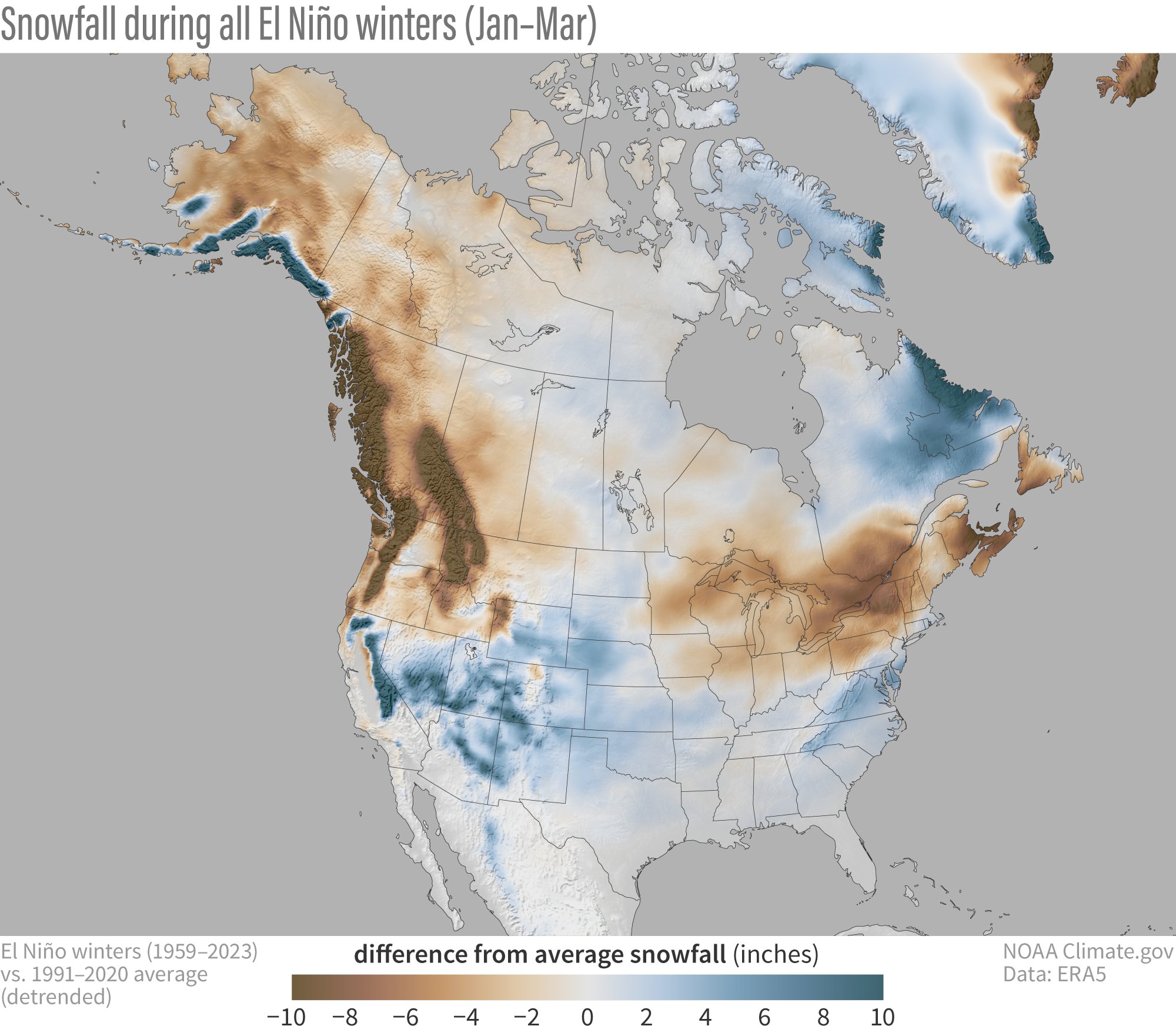
| Figure 1: Snowfall during all El Niño winters (January-March) compared to the 1991-2020 average (after the long-term trend has been removed). Blue colors show more snow than average; brown shows less snow than average. NOAA Climate.gov map, based on ERA5 data from 1959-2023 analyzed by Michelle L'Heureux. | ||
In the map below, over many regions, the anomalies become stronger (anomaly = difference from the long-term average), which makes sense because El Niño affects the climate. Stronger El Niño events tend to land a larger punch on our atmosphere, thus increasing the chance of seeing expected El Niño impacts.
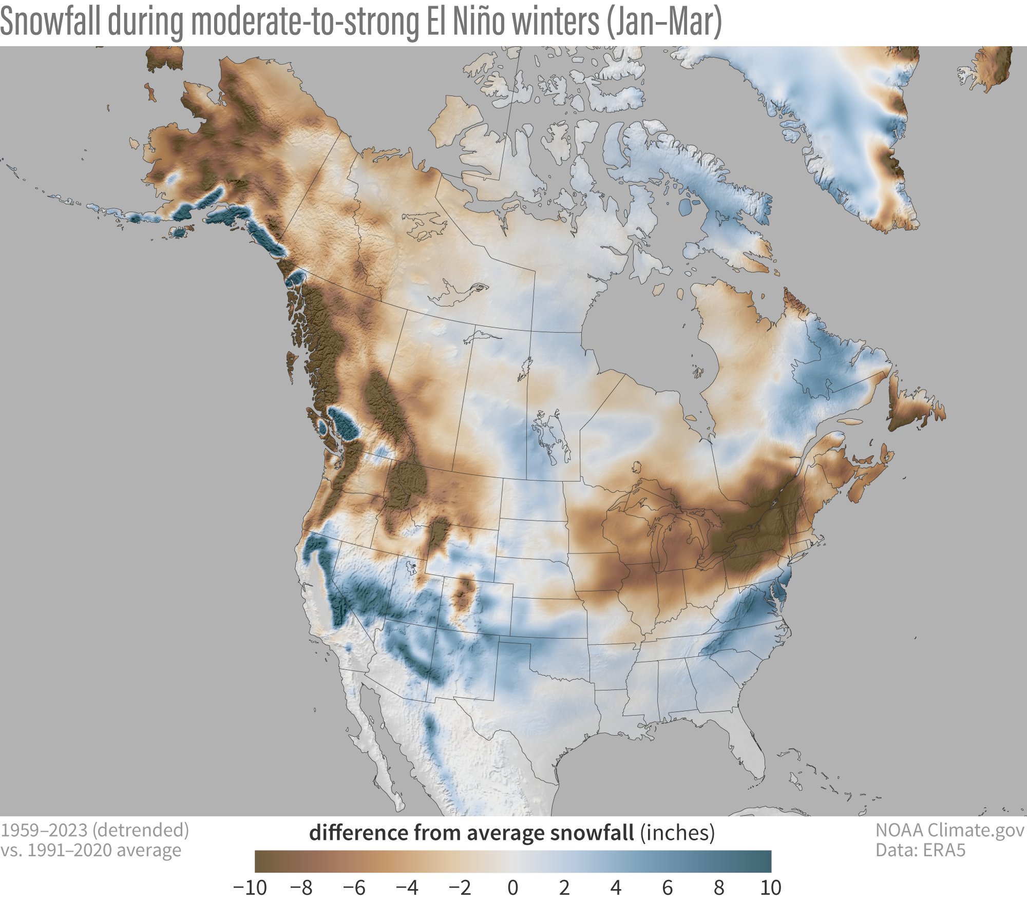 |
| Figure 2: Snowfall during moderate-to-strong El Niño winters (January-March) compared to the 1991-2020 average (after the long-term trend has been removed). Blue colors show more snow than average; brown shows less snow than average. NOAA Climate.gov map, based on ERA5 data from 1959-2023 analyzed by Michelle L'Heureux. |
While the maps above may excite or depress you depending on your situation and snow preferences, it is very important to recognize that the map is the showing the average of all winters with El Niño (footnote #2). Relying on the average is a bit dangerous because a few heavy snowfall winters can give the impression that most winters are above average. This is why it’s important to recognize there can be large variations from winter to winter.
Below is a map showing a count of El Niño winters: Here, we ask how many of the 13 moderate-to-strong El Niño winters had below-average snowfall. If it is in red shading, that means most winters had below-average snowfall. The deepest reds mean almost all past winters had below-average snowfall (black indicates no snowfall at all, which makes sense if you’re sitting on a beach in South Florida). If it is in grey shading, that means most moderate-to-strong winters had above-average snowfall.
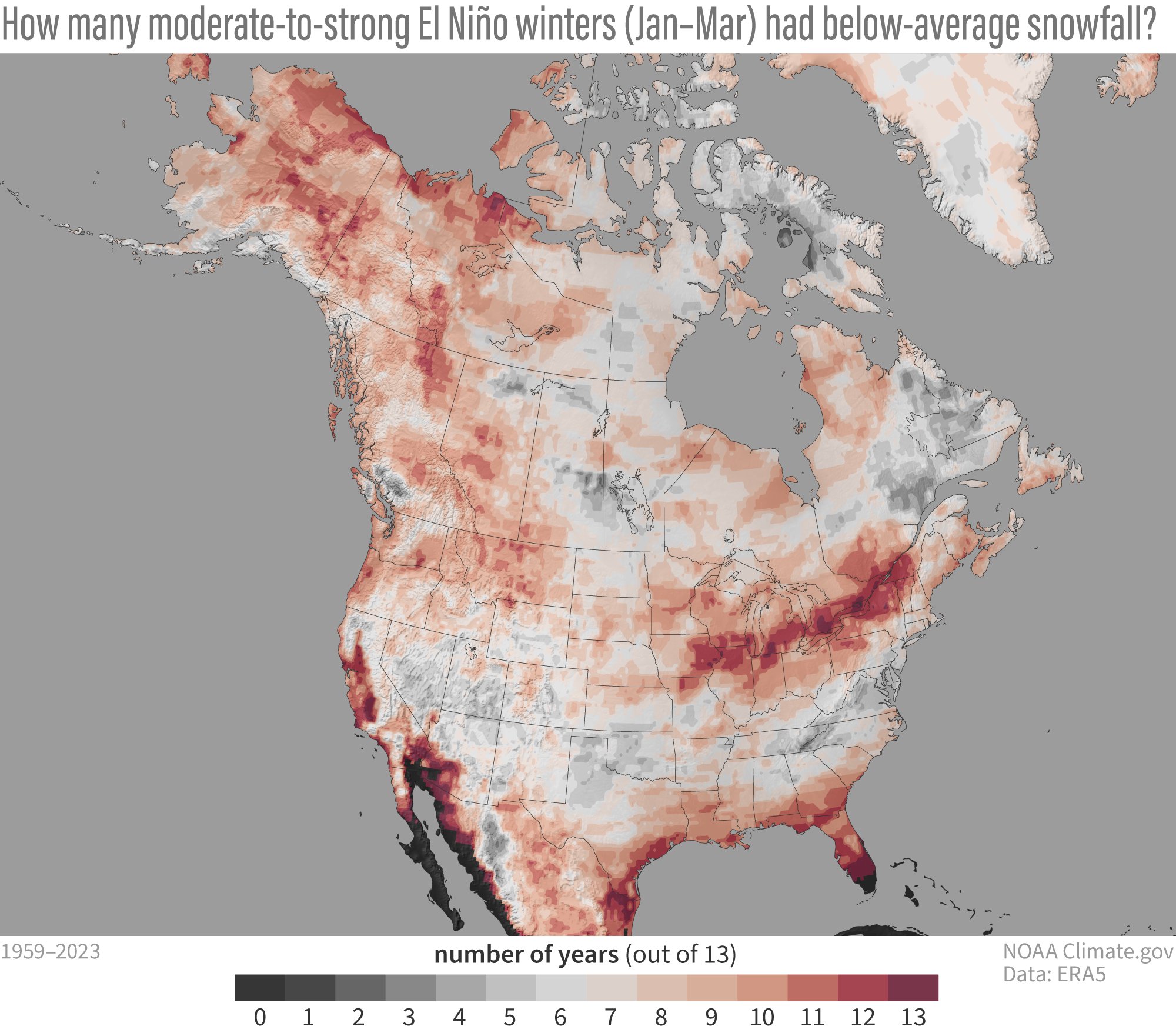 |
| Figure 3: Number of years with below-average snowfall during the 13 moderate-to-strong El Niño winters (January-March average) since 1959. Red shows locations where more than half the years had below-average snowfall; gray areas below-average snowfall less than half the time. NOAA Climate.gov map, based on ERA5 data from 1959-2023 analyzed by Michelle L'Heureux. |
Another major caveat related to these maps is they are just based on snowfall during El Niño. When the long-term trends are removed, there is also a trend in snowfall, and it looks like this over North America during January-March.
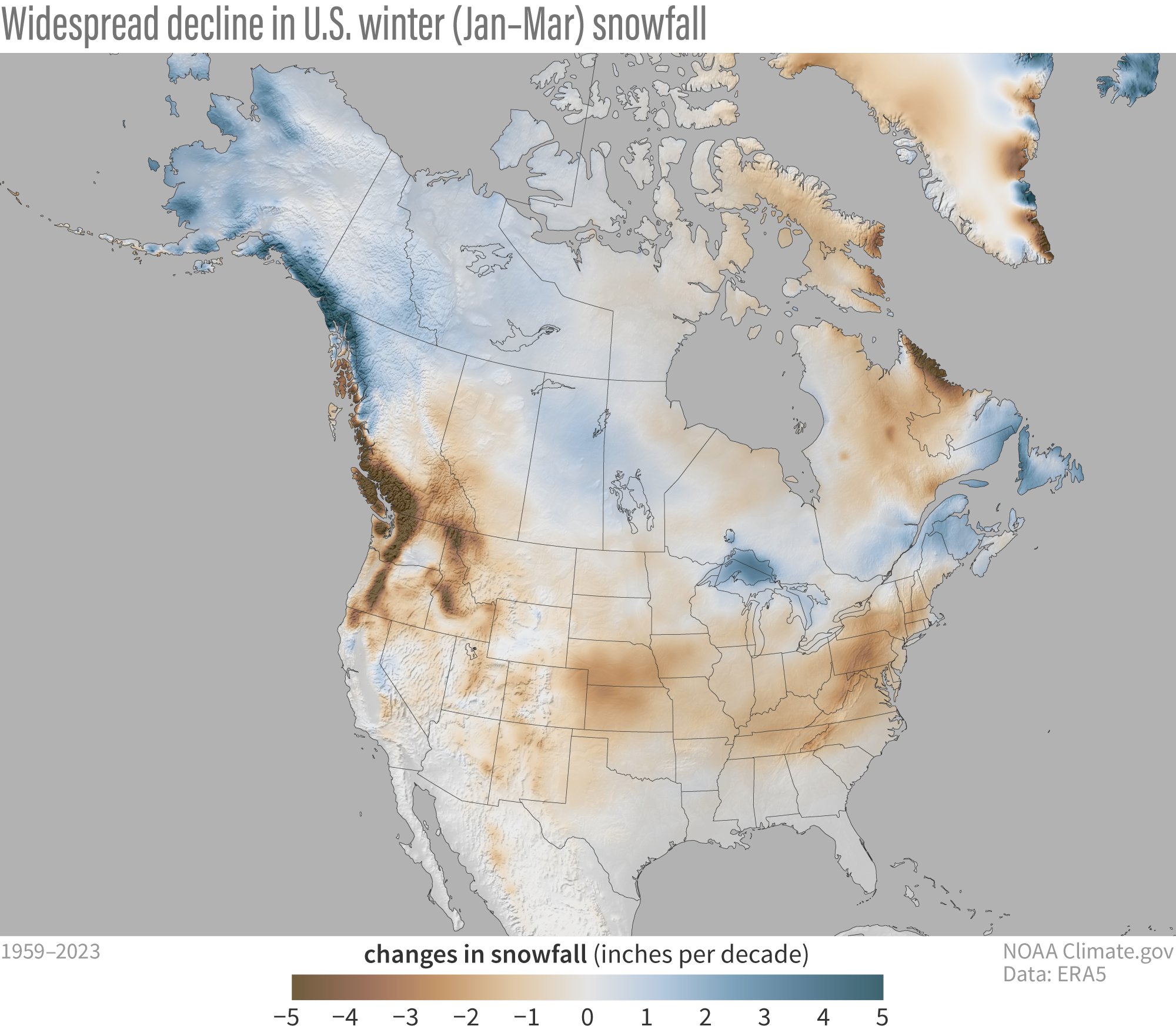 |
| Figure 4: Changes in snowfall (in inches per decade) between 1959 and 2023. Across most of the United States—Alaska being the major exception—snowfall has declined (brown colors). NOAA Climate.gov map, based on ERA5 data from 1959-2023 analyzed by Michelle L'Heureux. |
Unsurprisingly, because of climate change, over most of the contiguous United States, we have trended toward less snowy winters. This doesn’t mean that it never snows, or we cannot get big snowstorms (footnote #3), but that snowfall has gradually trended downward over time. In contrast, wintertime snowfall may have actually increased somewhat over time over the colder northern latitudes of Alaska and parts of Canada (this trend reverses in the spring; see footnote #4). Why would that be the case? Well, if you think about it, the warming of our planet allows the air to hold more moisture. If the atmospheric circulation allows for it, then that moisture can be wrung out of the air and precipitate. Snowfall also depends on the air temperature remaining below the freezing point. At more northern latitudes, despite warming air temperatures, it still remains cold enough in the winter to fall as snow. But there is no such luck in more southern locations which are often closer to the freezing point. There, the tendency toward warmer winters is a snow killer.
The predictability of seasonal snowfall may be somewhat similar to precipitation in that one or two big events can dramatically affect the seasonal average. Thus, in general, the expected prediction skill is likely to be lower than for temperature. However, because temperature also plays an important role in snowfall, some predictability is likely nonetheless. And like for seasonal temperature and precipitation, knowing the state of ENSO is a pretty reasonable place to start.
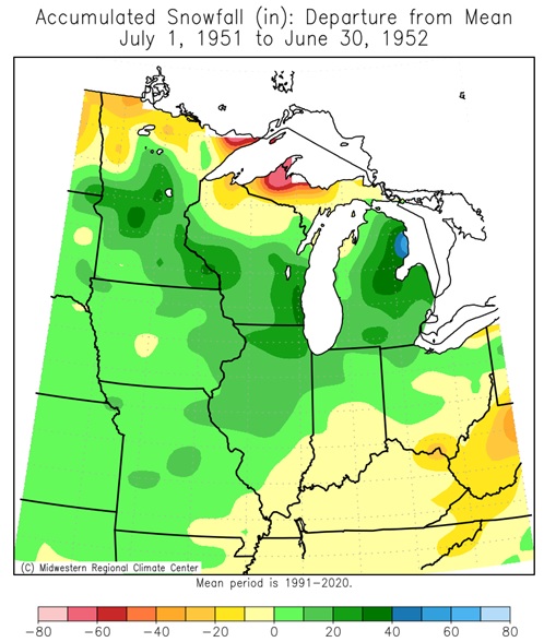
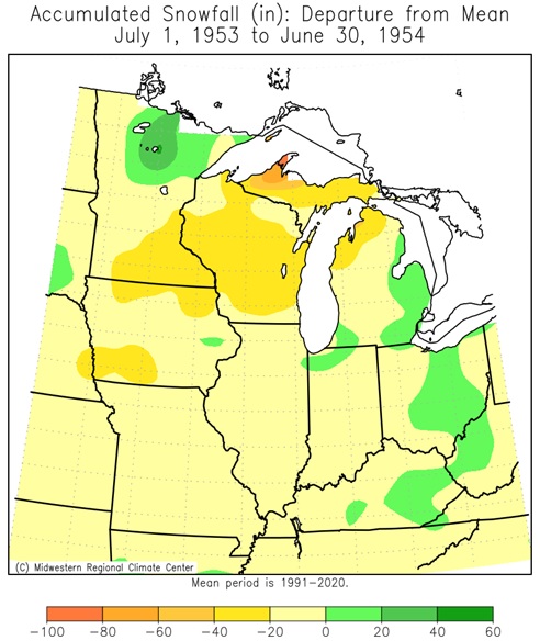
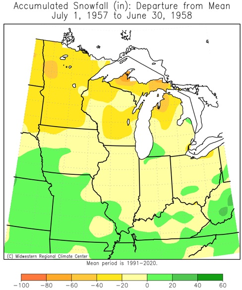
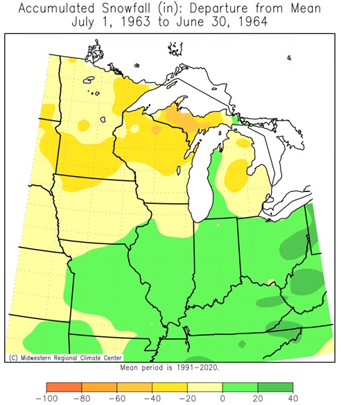
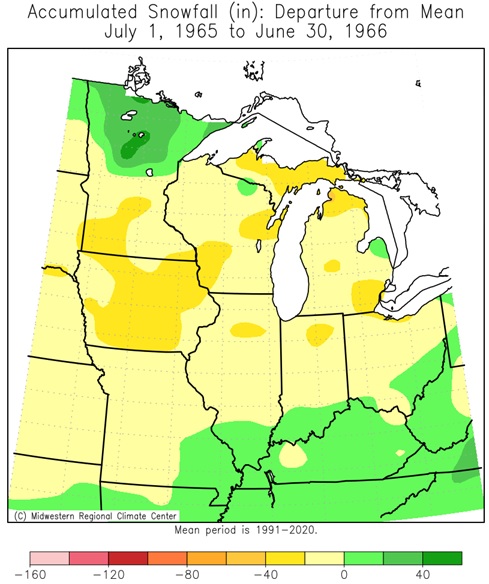
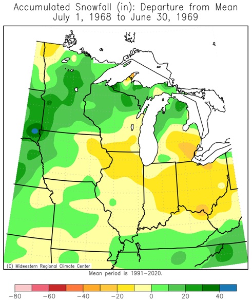
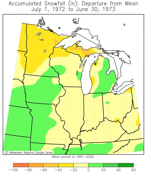
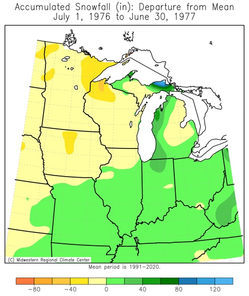
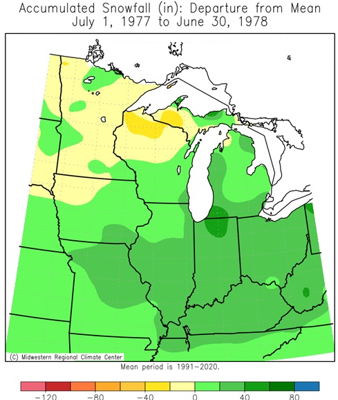
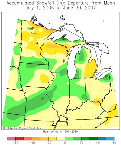
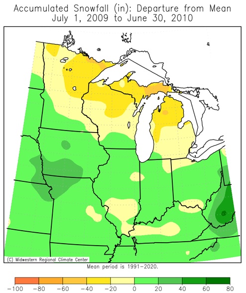
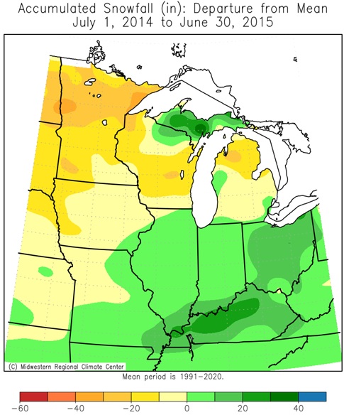
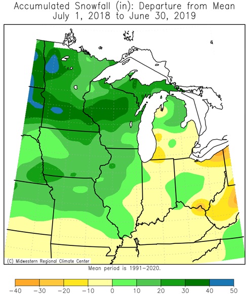
Midwest El Niño Seasonal Snow Departures (26 Winters since 1949-50)
 |
 |
 |
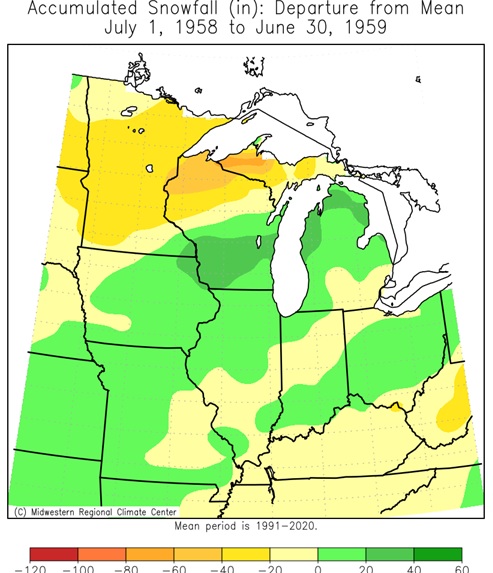 |
| 1951-1952 | 1953-1954 | 1957-1958 | 1958-1959 |
 |
 |
 |
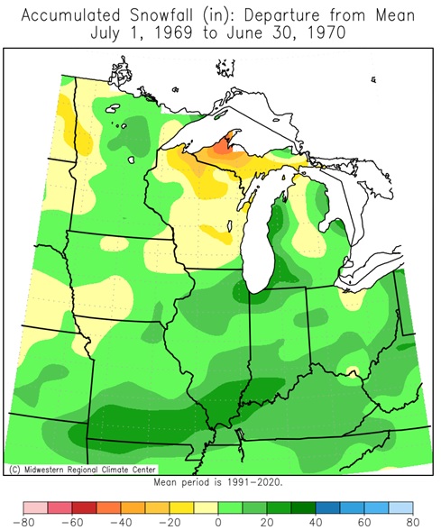 |
| 1963-1964 | 1965-1966 | 1968-1969 | 1969-1970 |
 |
 |
 |
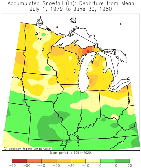 |
| 1972-1973 | 1976-1977 | 1977-1978 | 1979-1980 |
 |
 |
 |
 |
| 1982-1983 | 1986-1987 | 1987-1988 | 1991-1992 |
 |
 |
 |
 |
| 1994-1995 | 1997-1998 | 2002-2003 | 2004-2005 |
 |
 |
 |
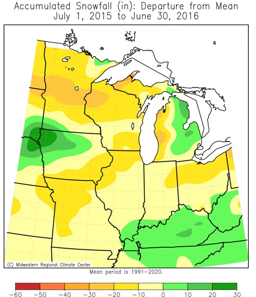 |
| 2006-2007 | 2009-2010 | 2014-2015 | 2015-2016 |
 |
 |
||
| 2018-2019 | 2023-2024 |
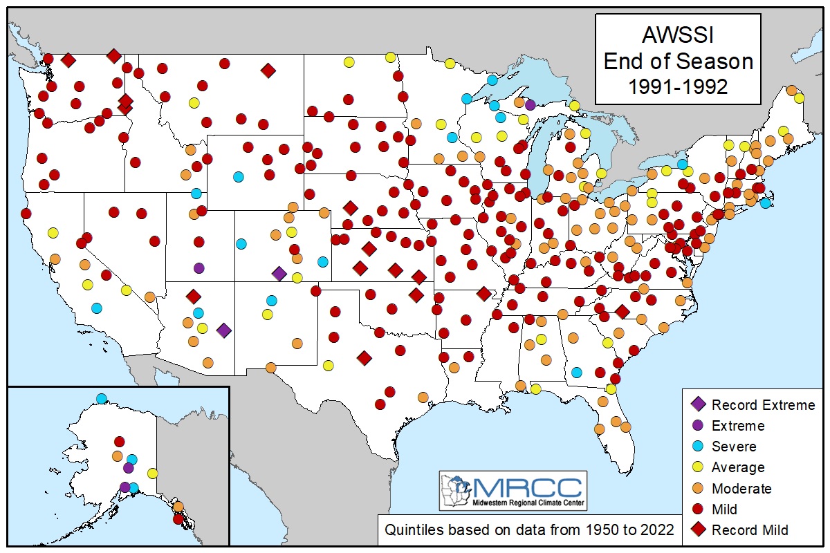
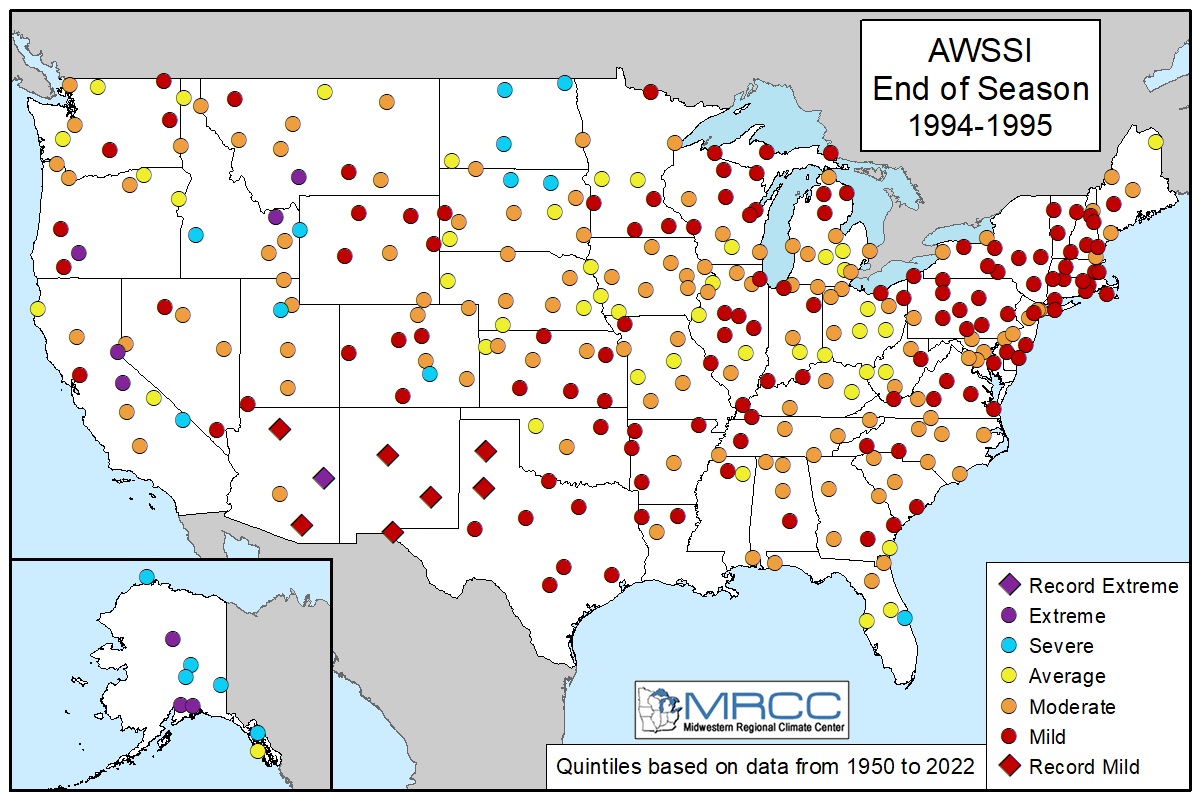
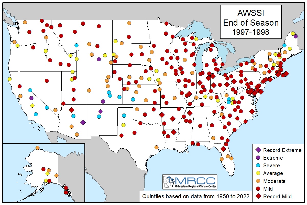
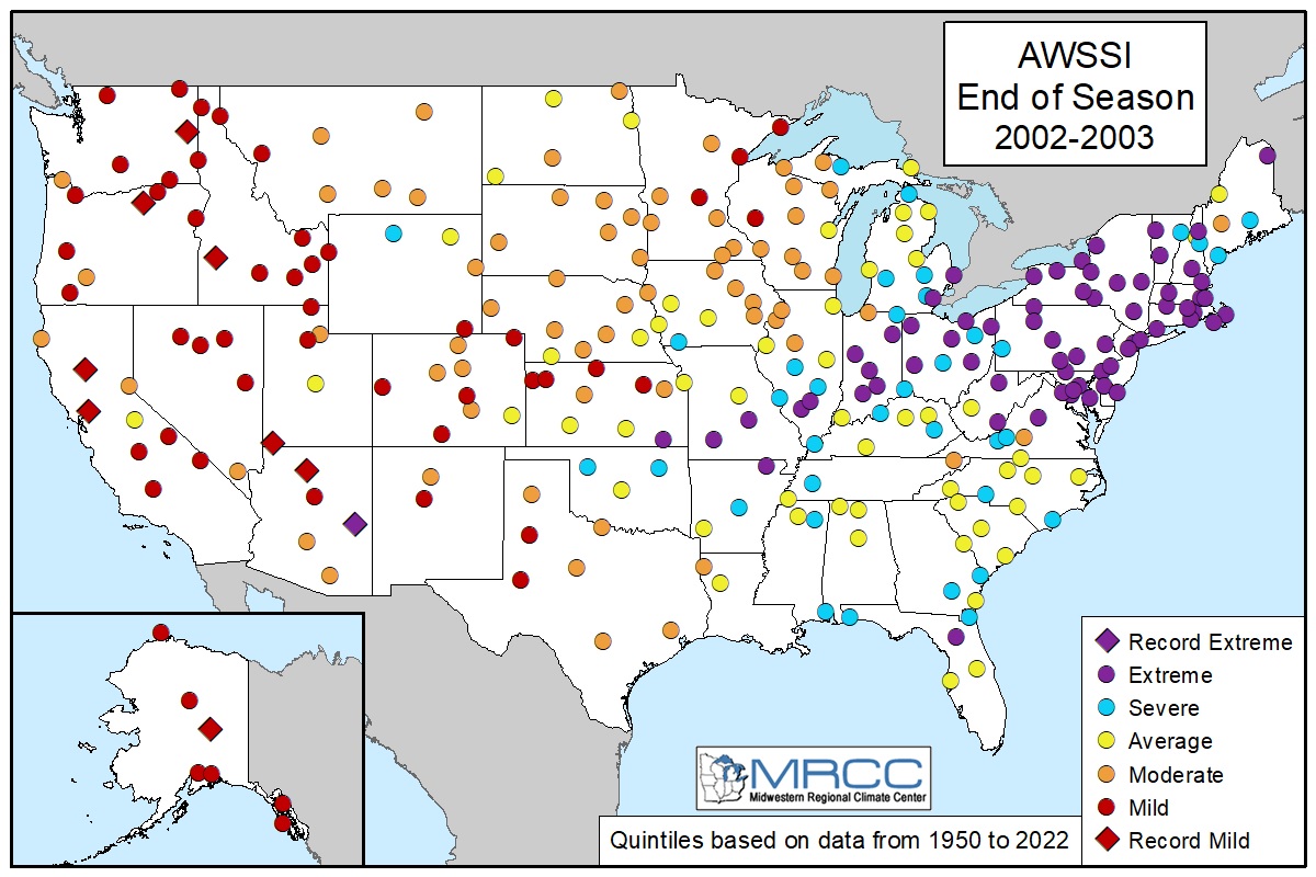
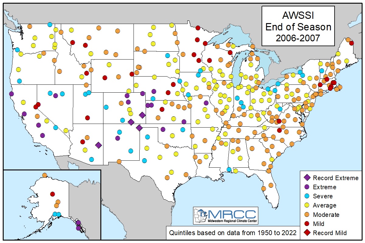
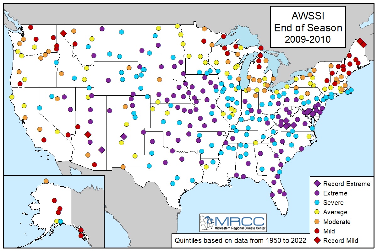
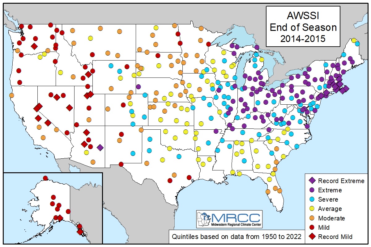
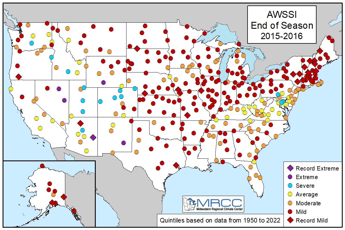
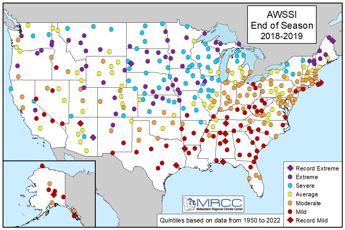
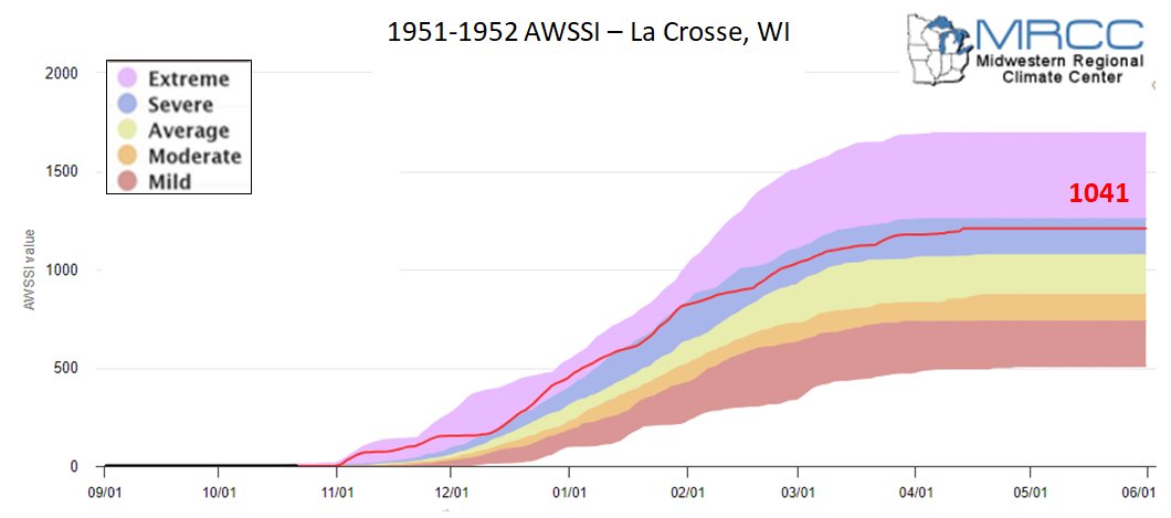
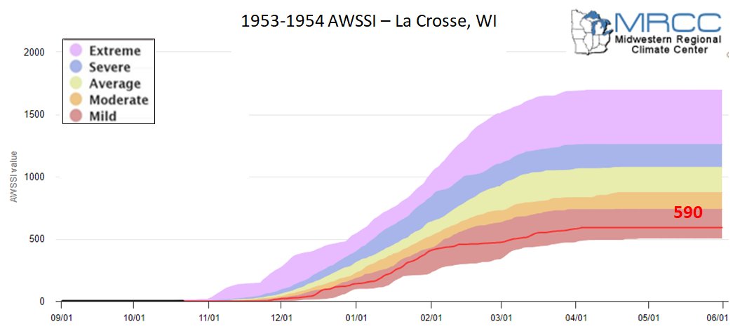
El Niño AWSSI
Author: Midwestern Regional Climate Center
|
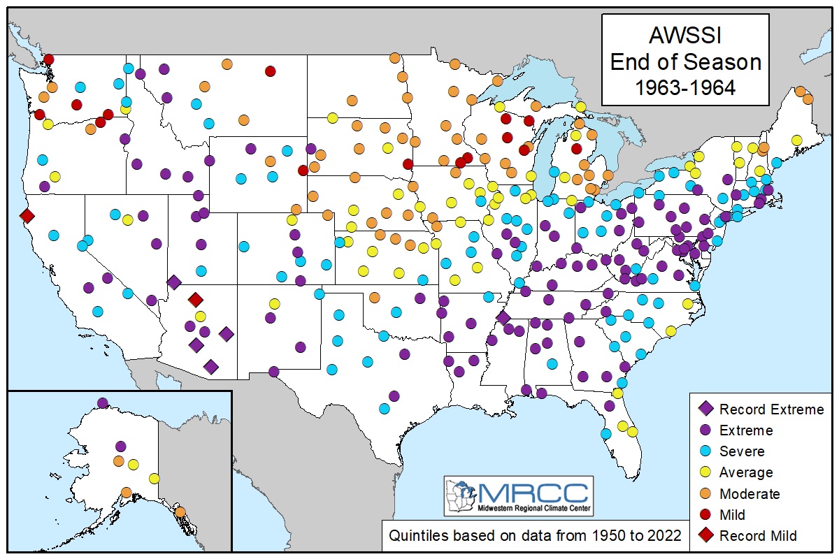
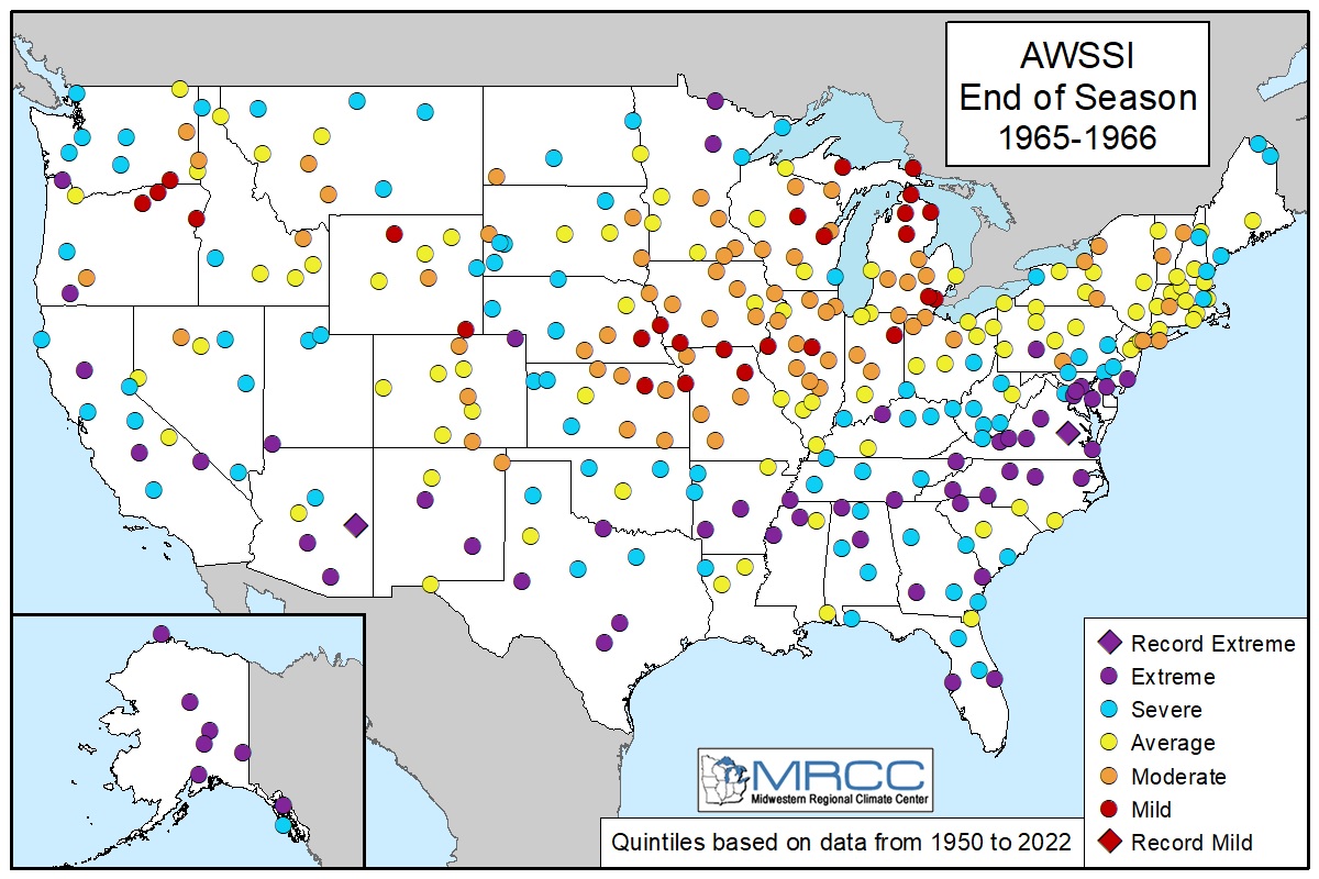
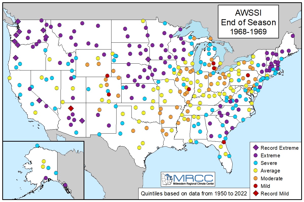
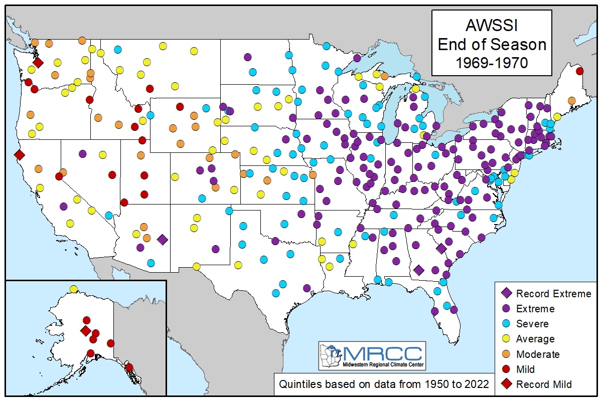
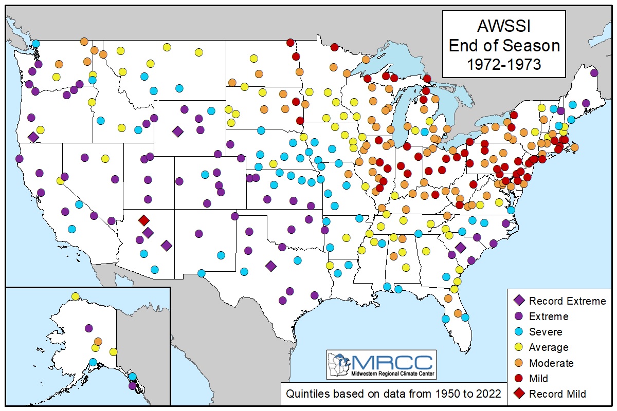
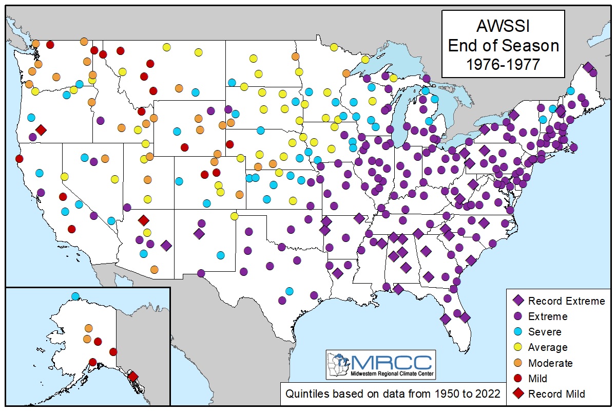
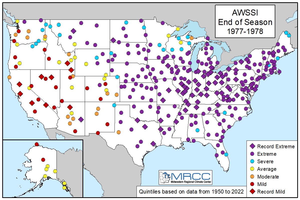
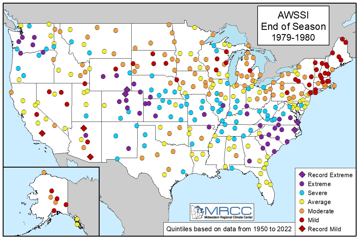
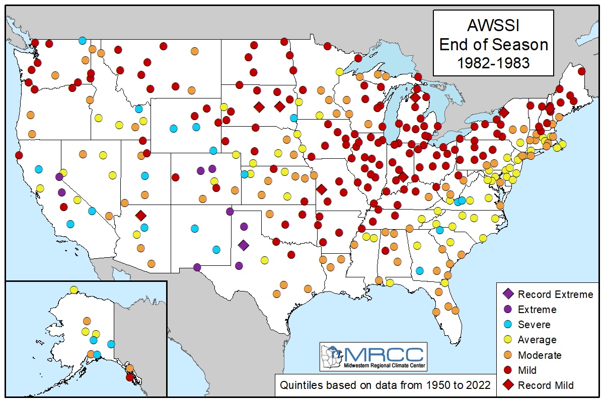
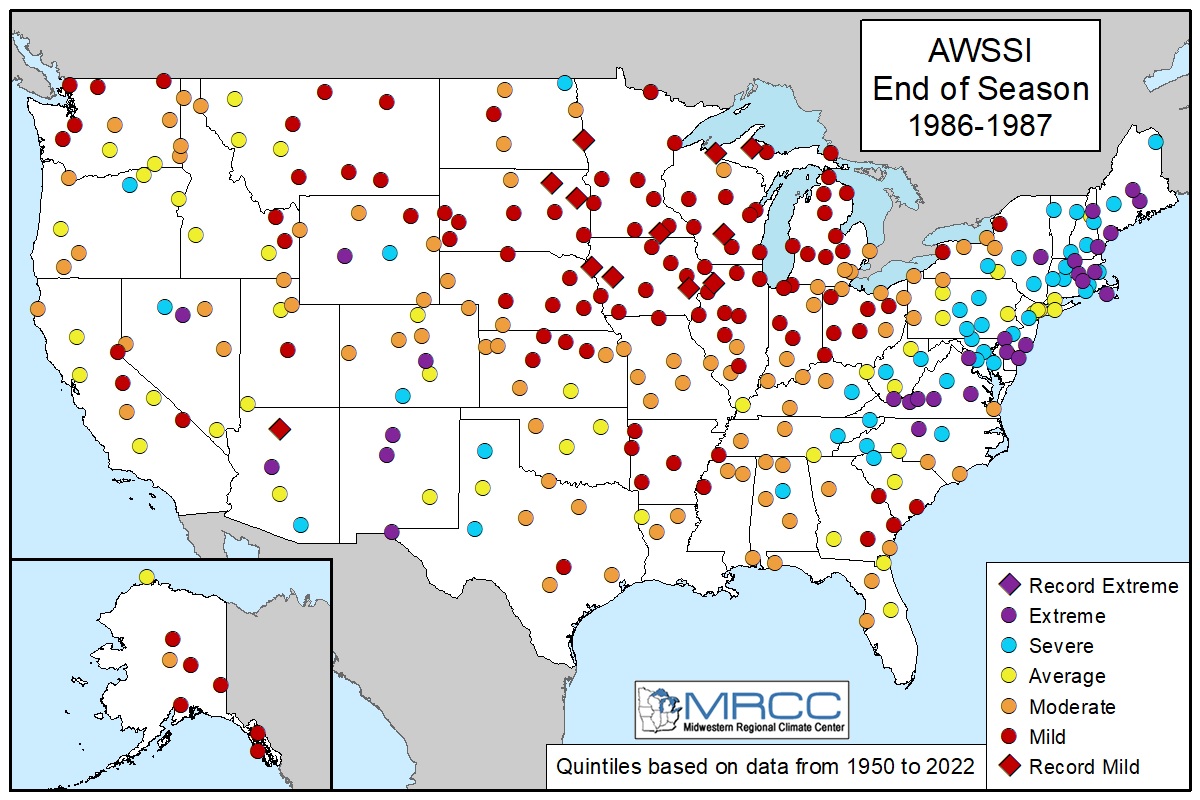
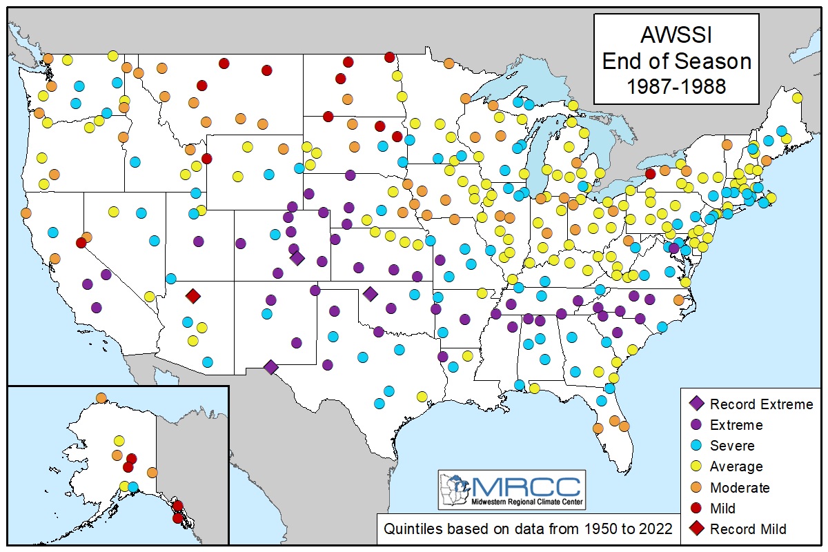
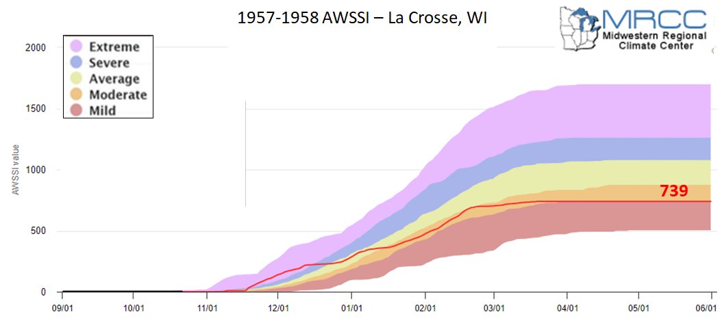
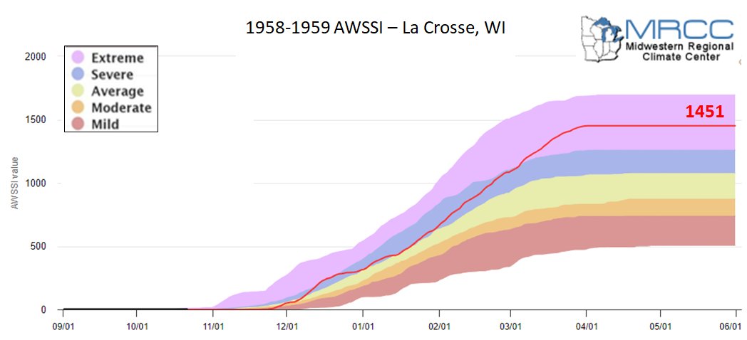
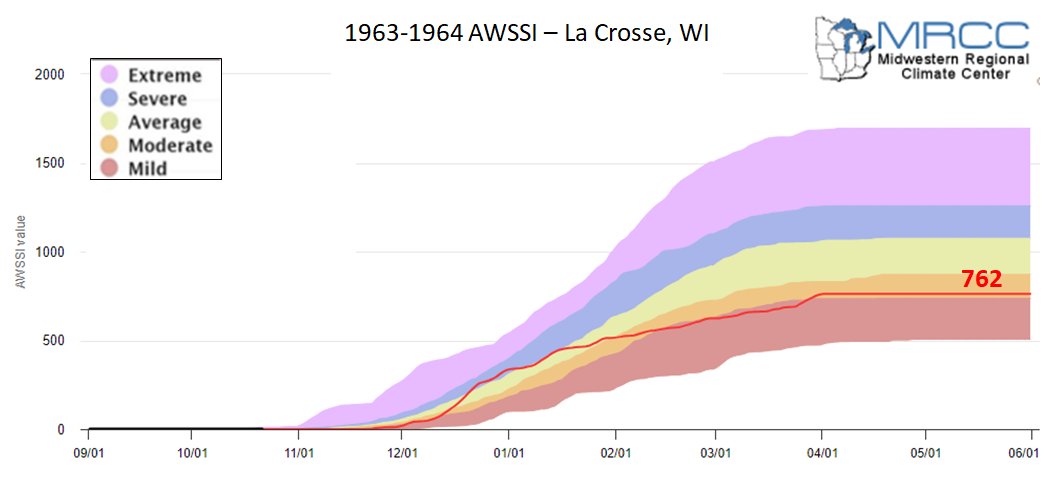
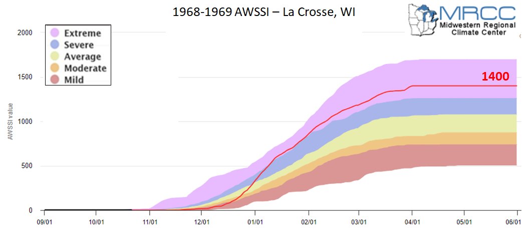
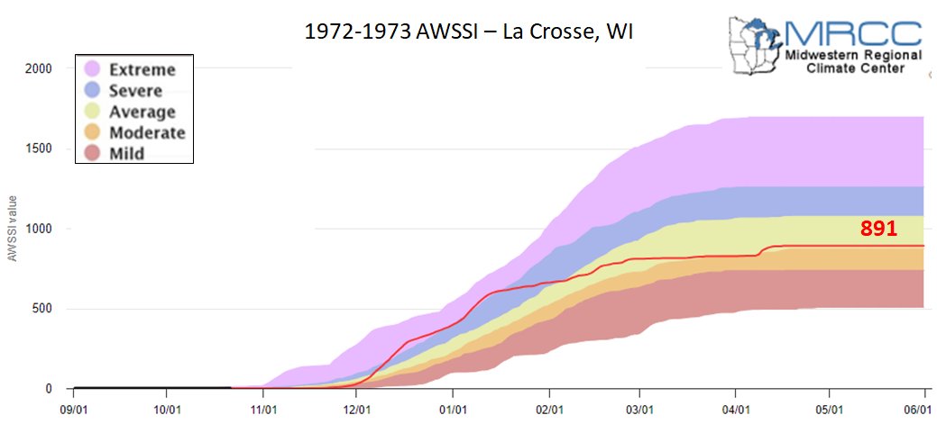
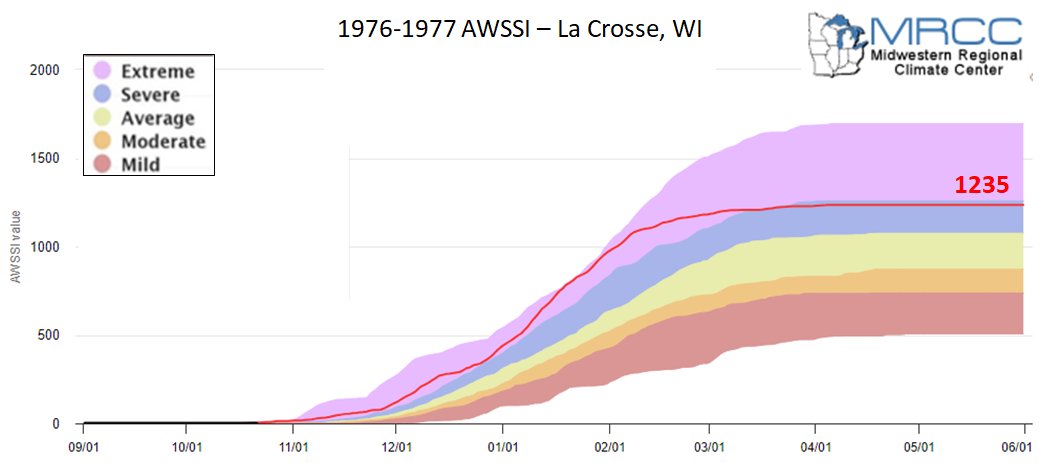
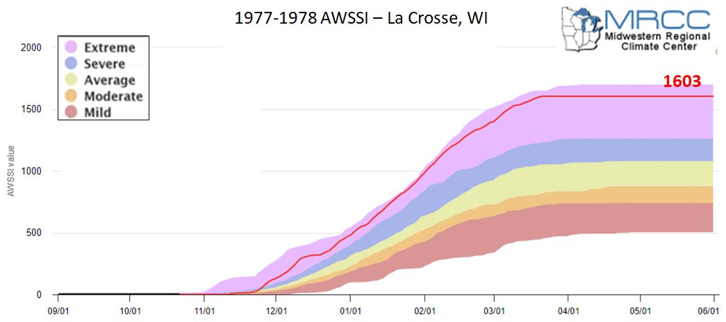
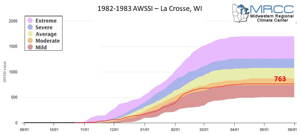
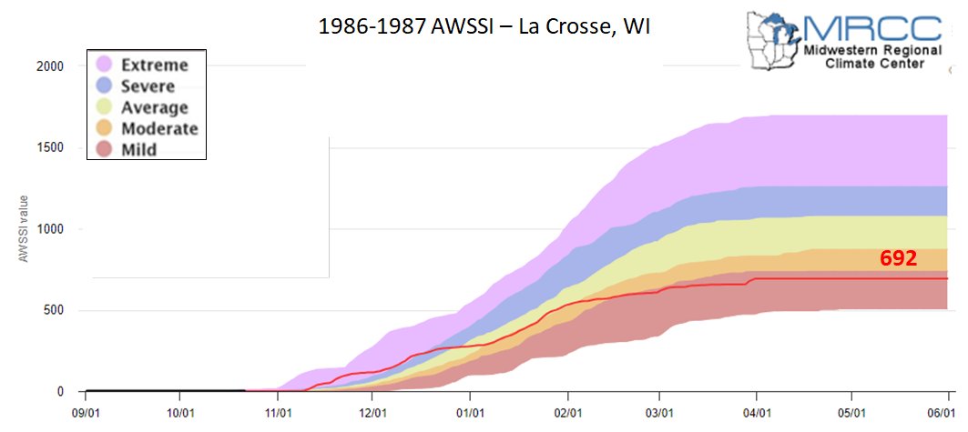
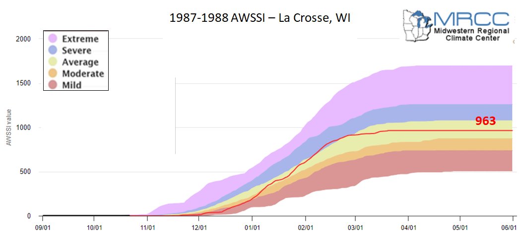
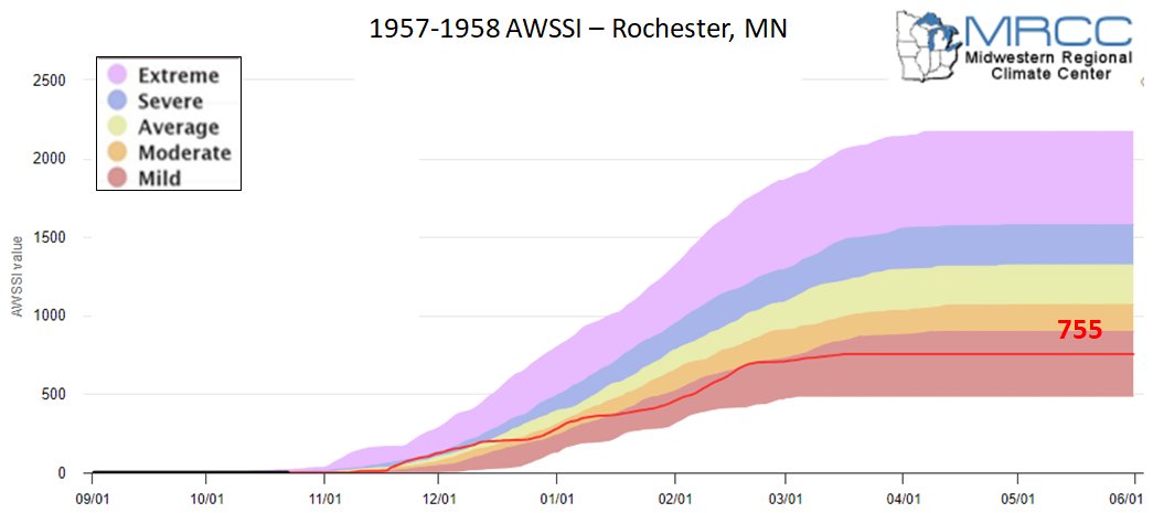
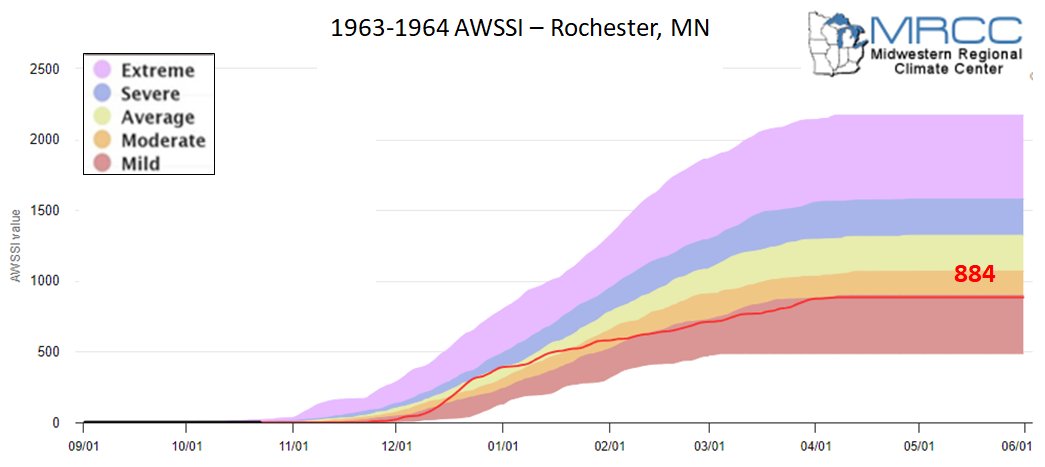
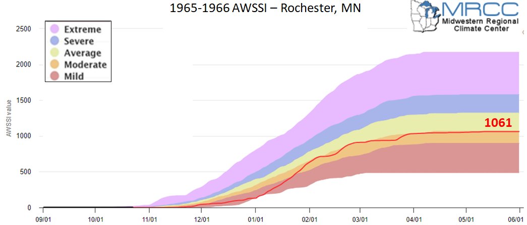
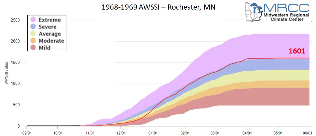
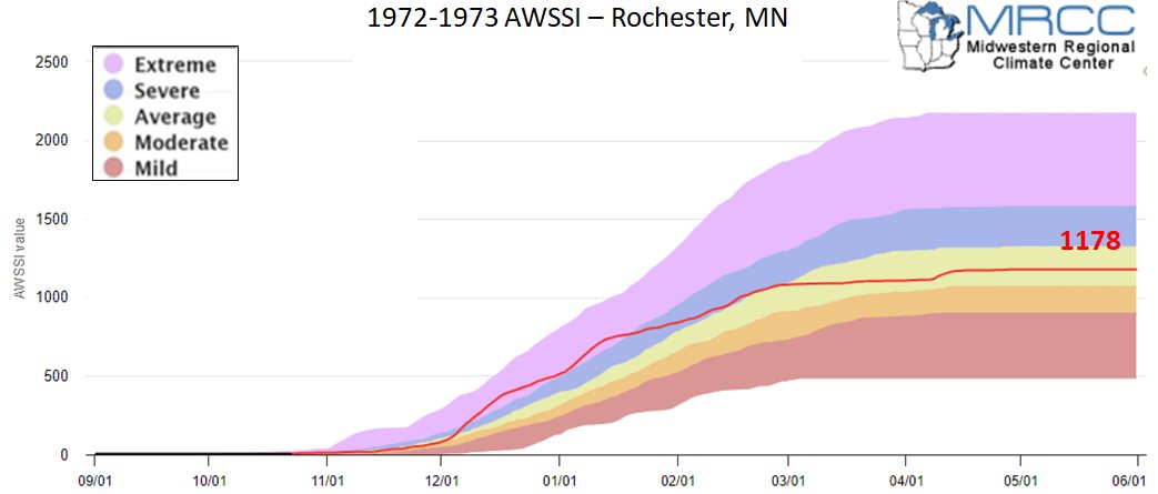
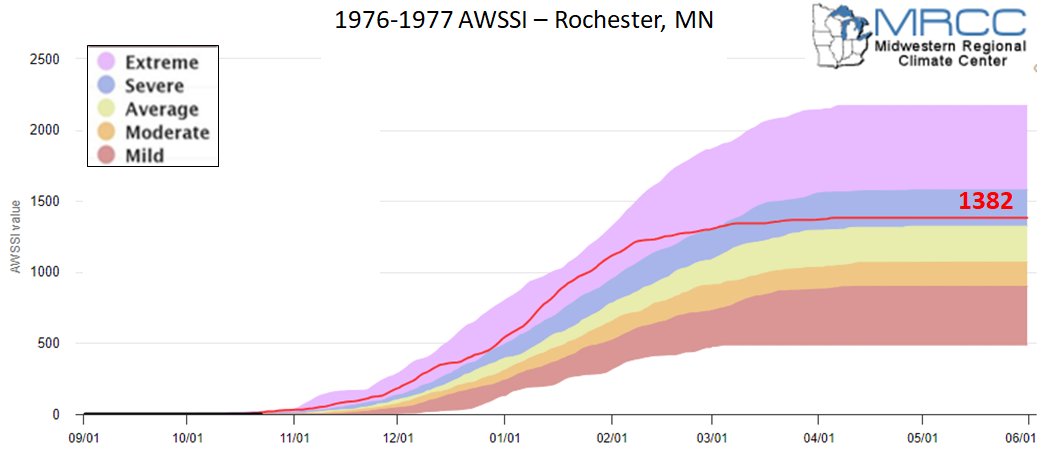
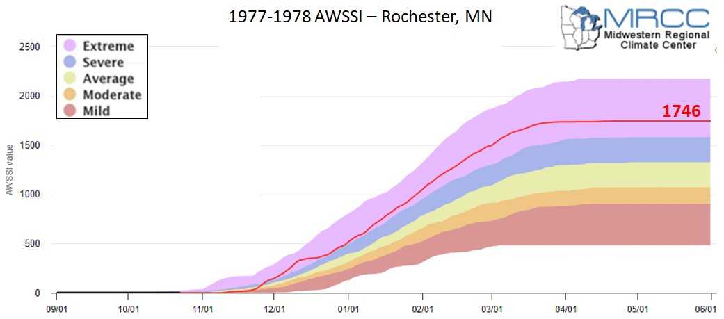
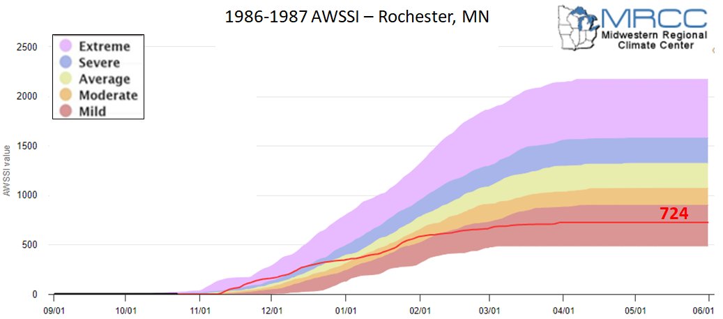
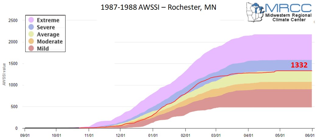
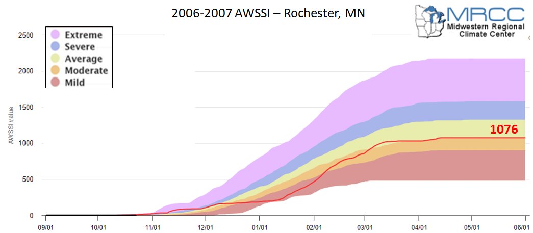
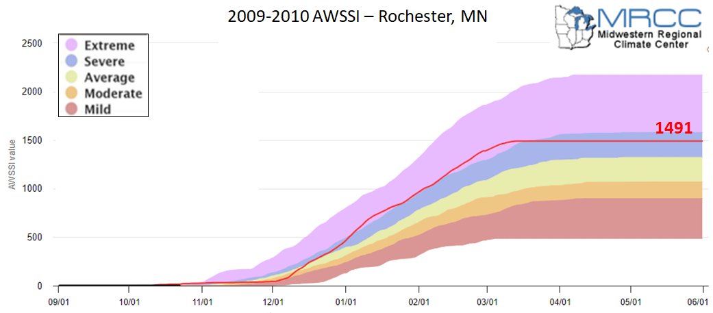
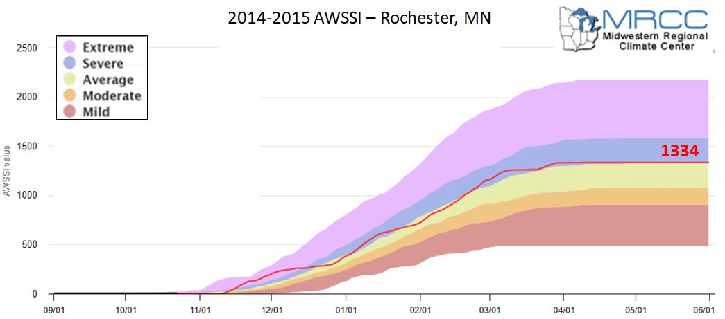
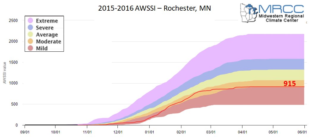
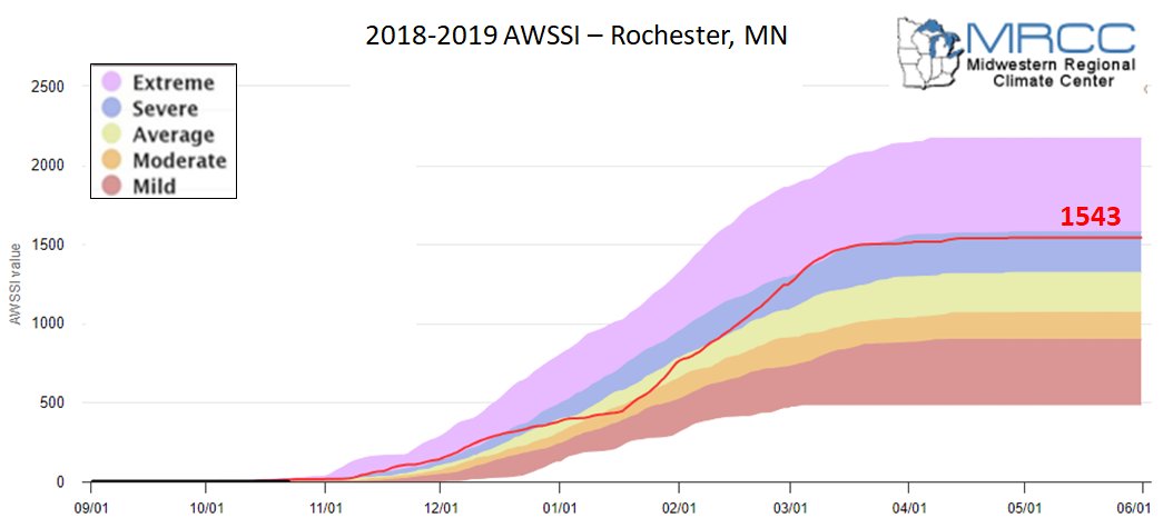
Winter seasons have significant societal impacts across all sectors ranging from direct human health and mortality to commerce, transportation, and education. The question “How severe was this winter?” does not have a simple answer. At the very least, the severity of a winter is related to the intensity and persistence of cold weather, the amount of snow, and the amount and persistence of snow on the ground. The Accumulated Winter Season Severity Index (AWSSI) was developed to objectively quantify and describe the relative severity of the winter season. |
|
Goals of the AWSSI
|
Limitations
|
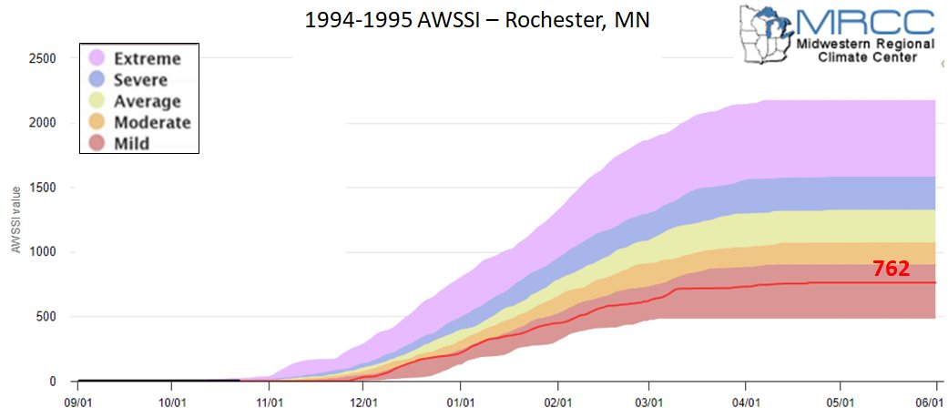
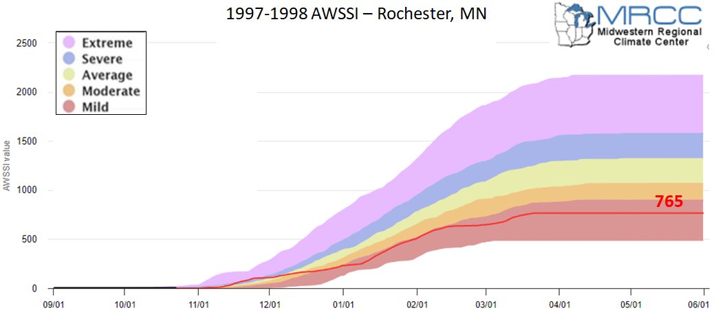
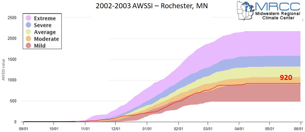
How does the AWSSI accumulate?
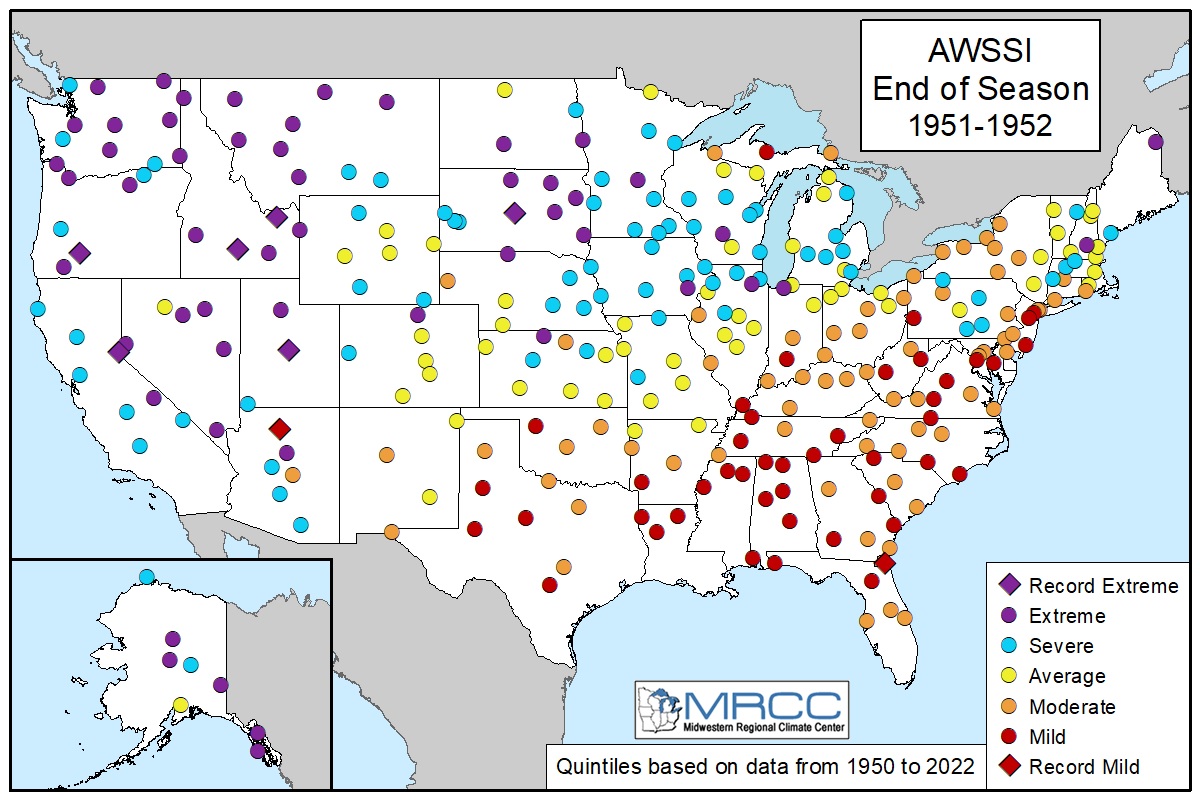
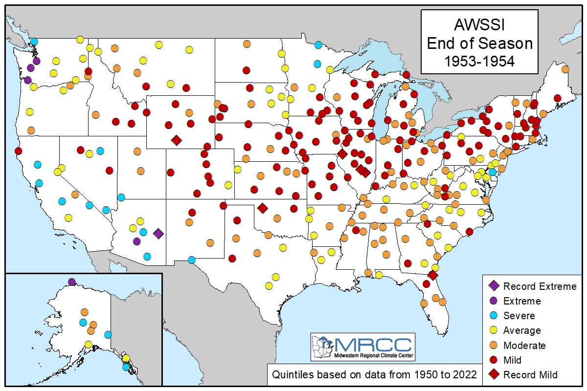
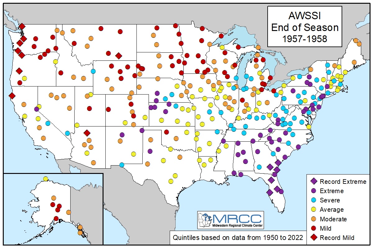
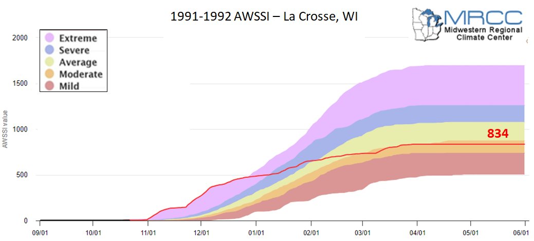
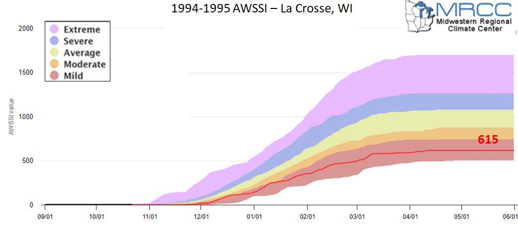
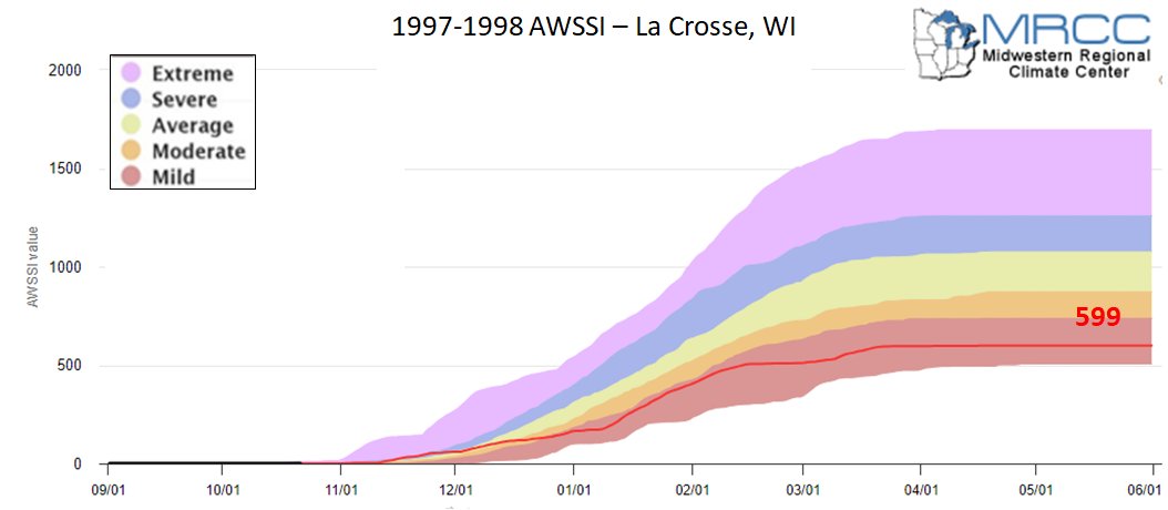
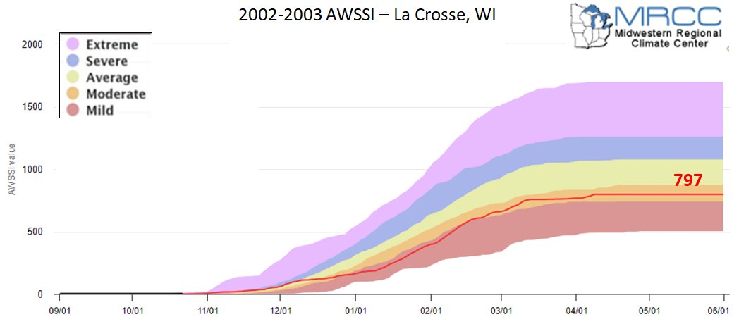
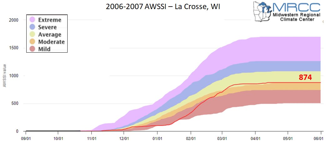
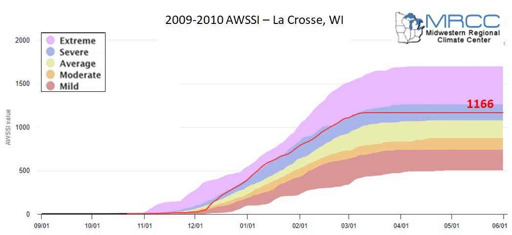
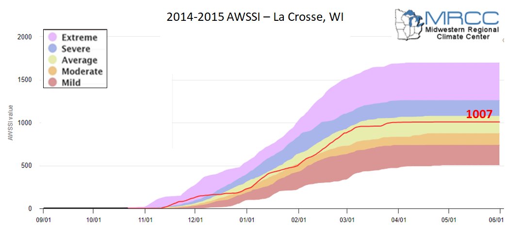
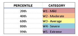
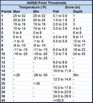
First measurable snowfall (>= 0.1 inch) The winter season ends at the last occurrence of any of the following: Daily scores are calculated based on scores assigned to temperature, snowfall, and snow depth thresholds. The daily scores are accumulated through the winter season, allowing a running total of winter severity in the midst of a season as well as a final, cumulative value characterizing the full season. Accumulations of the temperature and snow components of the index are computed separately and then added together for the total index. This allows a comparison of the relative contribution of each to the total score. The AWSSI has been processed for 52 locations across the continental U.S. to provide a variety of locations in different climate regimes for analysis. The AWSSI is calculated for each season from 1950â€1951 to 2012â€2013. The seasonal data is then subject to quality control, and seasons missing data that would contribute 5% or more of the seasons AWSSI are removed. Averages and standard deviations are calculated for running accumulations of daily temperature and snow scores as well as the total AWSSI. The AWSSI data is gathered every hour throughout the day. Quintiles of AWSSI scores were determined for each location. Descriptive categories were assigned to each quintile as follows:
|
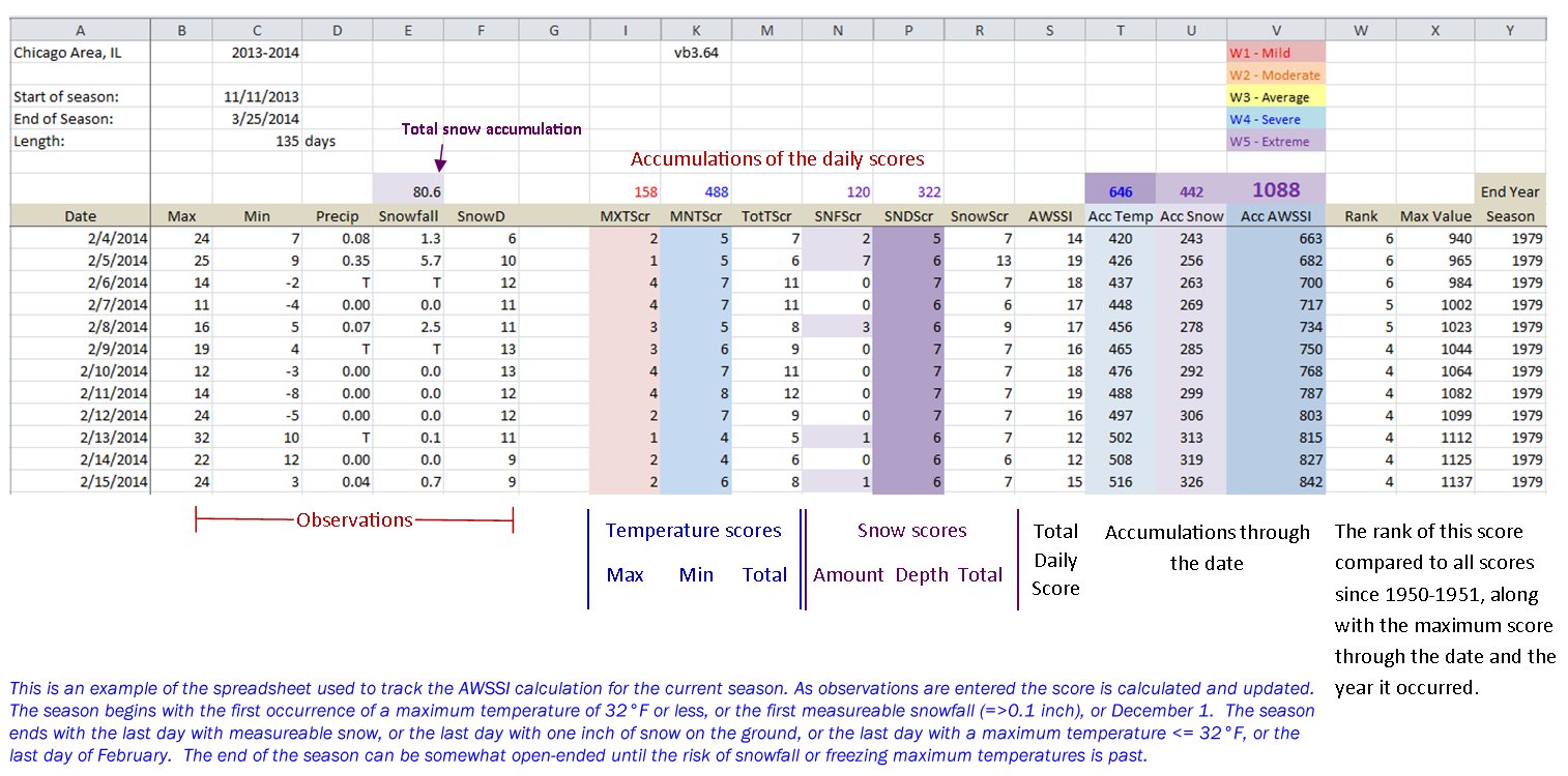
Annotated Scoring Page Sample: |
CONUS AWSSI during El Niño (25 Winters since 1951-52)
 |
 |
 |
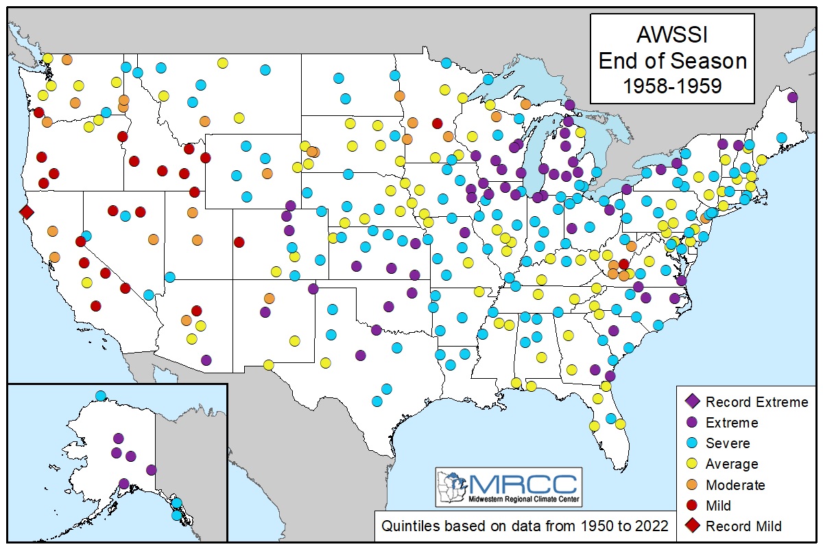 |
| 1951-1952 | 1953-1954 | 1957-1958 | 1958-1959 |
 |
 |
 |
 |
| 1963-1964 | 1965-1966 | 1968-1969 | 1969-1970 |
 |
 |
 |
 |
| 1972-1973 | 1976-1977 | 1977-1978 | 1979-1980 |
 |
 |
 |
 |
| 1982-1983 | 1986-1987 | 1987-1988 | 1991-1992 |
 |
 |
 |
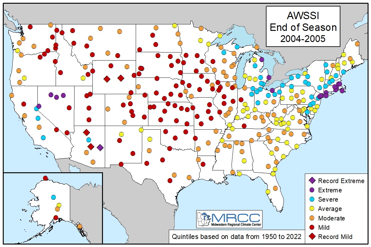 |
| 1994-1995 | 1997-1998 | 2002-2003 | 2004-2005 |
 |
 |
 |
 |
| 2006-2007 | 2009-2010 | 2014-2015 | 2015-2016 |
 |
 |
||
| 2018-2019 | 2023-2024 |
 |
 |
 |
 |
| 1951-1952 | 1953-1954 | 1957-1958 | 1958-1959 |
 |
 |
 |
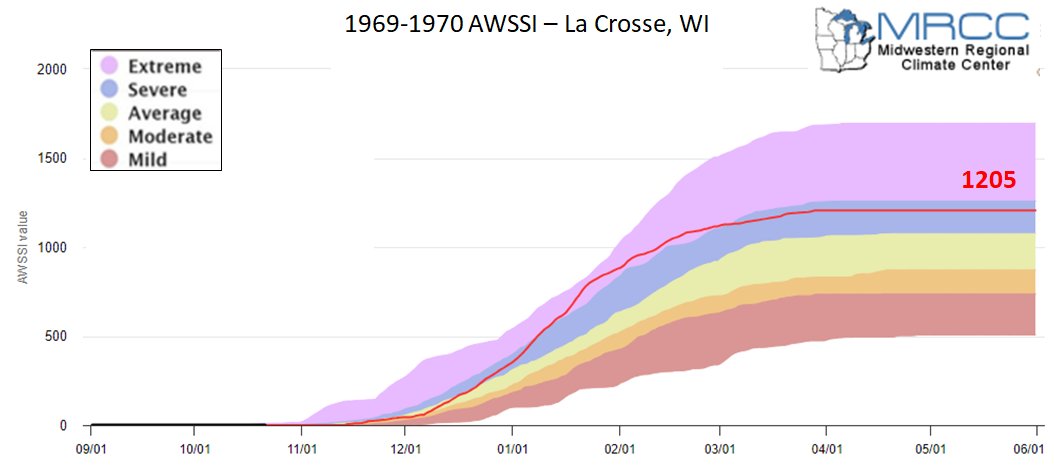 |
| 1963-1964 | 1965-1966 | 1968-1969 | 1969-1970 |
 |
 |
 |
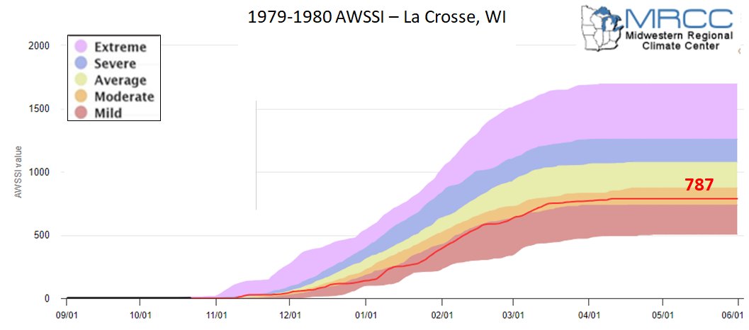 |
| 1972-1973 | 1976-1977 | 1977-1978 | 1979-1980 |
 |
 |
 |
 |
| 1982-1983 | 1987-1987 | 1987-1988 | 1991-1992 |
 |
 |
 |
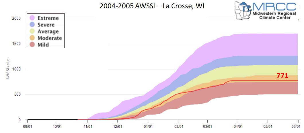 |
| 1994-1995 | 1997-1998 | 2002-2003 | 2004-2005 |
 |
 |
 |
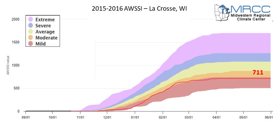 |
| 2006-2007 | 2009-2010 | 2014-2015 | 2015-2016 |
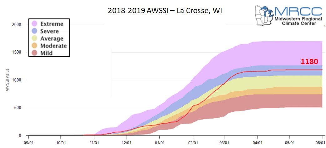 |
 |
The AWSSI Chart for 2026-2027 can be found at https://mrcc.purdue.edu/ research/AWSSI/ chart?stn=LSE |
|
| 2018-2019 | 2023-2024 | 2026-2027 |
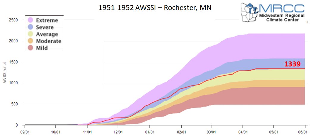 |
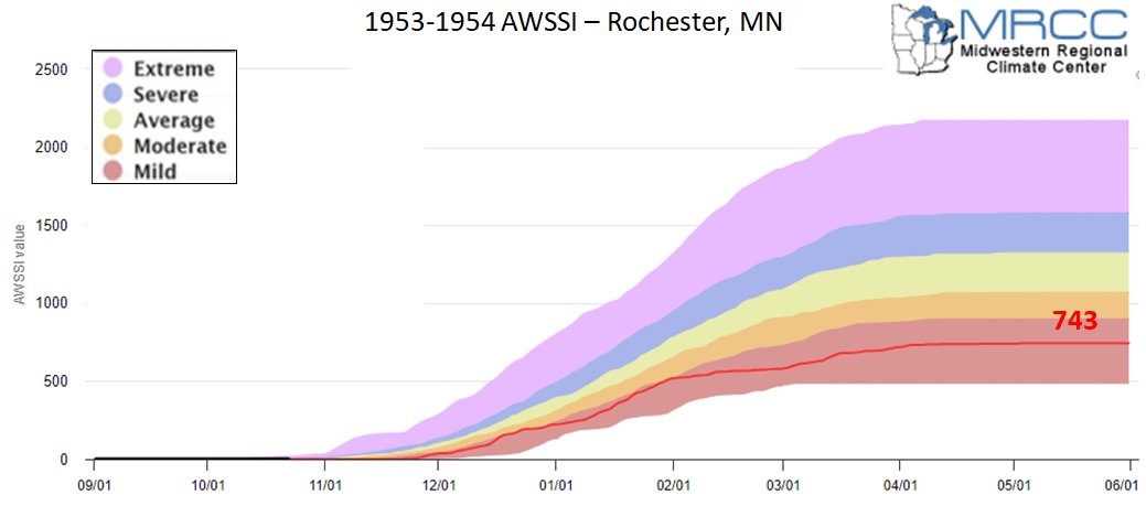 |
 |
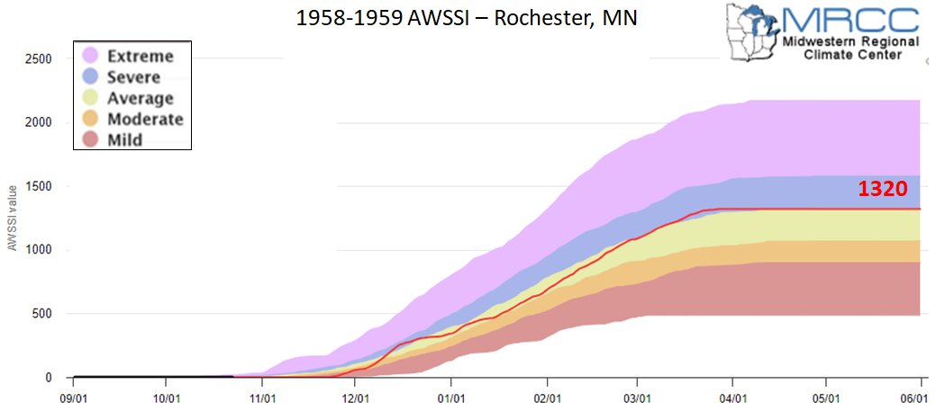 |
| 1951-1952 | 1953-1954 | 1957-1958 | 1958-1959 |
 |
 |
 |
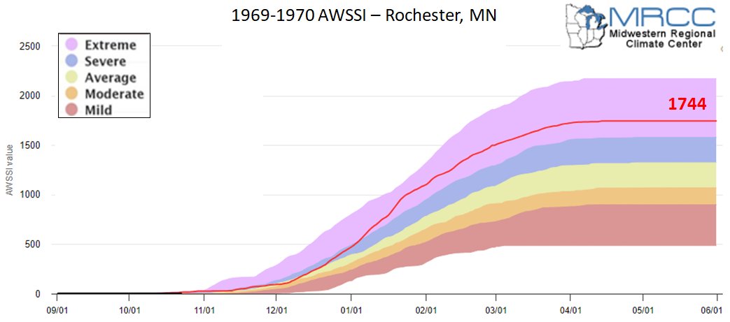 |
| 1963-1964 | 1965-1966 | 1968-1969 | 1969-1970 |
 |
 |
 |
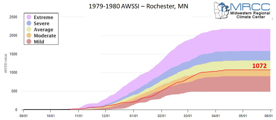 |
| 1972-1973 | 1976-1977 | 1977-1978 | 1979-1980 |
 |
 |
 |
 |
| 1982-1983 | 1986-1987 | 1987-1988 | 1991-1992 |
 |
 |
 |
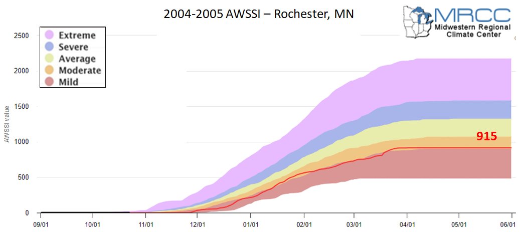 |
| 1994-1995 | 1997-1998 | 2002-2003 | 2004-2005 |
 |
 |
 |
 |
| 2006-2007 | 2009-2010 | 2014-2015 | 2015-2016 |
 |
 |
The AWSSI Chart for 2026-27 can be found at https://mrcc.purdue.edu/ research/AWSSI/ chart?stn=RST |
|
| 2018-2019 | 2023-2024 | 2026-2027 |
El Niño Severe Weather:
El Niño Severe Weather:
Author: Michael K. Tippett and Chiara Lepore
April 27, 2017
ENSO shifts the atmospheric circulation (notably, the jet stream) in ways that affect winter temperature and precipitation over the U.S. The changes in spring (March-May) are similar to those during winter but somewhat weaker.
These shifts would also be expected to impact thunderstorm activity: El Niño tends to shift the jet stream farther south over the U.S., which blocks moisture from the Gulf of America, reducing the fuel for thunderstorms. On the other hand, La Niña is associated with a more wavy and northward-shifted jet stream, which might be expected to enhance severe weather activity in the south and southeast. Indeed, historic tornado outbreaks in 1974, 2008, and 2011 started during La Niña conditions.
However, tornado and severe weather activity are more variable (“noisier” and harder to predict) than ordinary weather (think temperature and precipitation), and any ENSO signal is harder to see. Until recently, the only solid evidence showing that more tornadoes occur during La Niña conditions was for winter (January-March), when the ENSO signal is strongest, but average tornado activity is relatively low (Cook & Schaefer, 2008).
A clearer picture of the impact of ENSO emerges when we look at the ingredients that are conducive to tornado and thunderstorm occurrence (Allen et al., 2015a). Instead of only looking at individual weather events, it’s important to consider the environmental cues for the outbreak of severe weather.
Two important ingredients for tornadoes are atmospheric instability (e.g., warm, moist air near the surface and cool dry air aloft) and vertical wind shear (winds at different altitudes blowing in different directions or speeds). Measures of these tornado-friendly ingredients can be combined into indexes that are less noisy than actual tornado reports and let us see how the phases of ENSO make the environment more or less favorable for severe weather (footnote 1).
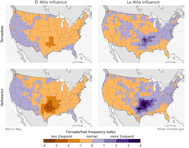
In much of the U.S., La Niña conditions are associated with increases in these environmental factors and in tornado and hail reports. The largest signal is present in the south and southeast (including parts of Texas, Oklahoma, Kansas, Louisiana, Arkansas, and Missouri), except in Florida where the opposite relation is observed. Positive values indicate increased activity and negative values indicate decreased activity compared to the long-term average (1979-2015).
 |
||||||||||
| Figure 1: Sea surface temperature pattern showing the warm phase of the Pacific Decadal Oscillation (top). The status of the PDO between 1950 and this year, shown at the bottom, indicates a predominantly positive phase from about 1978 to 1998 and a negative phase since 1999. Image Credit: Climate Impacts Group, University of Washington. | ||||||||||
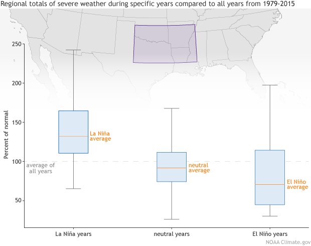
In the South and Southeast, where the signal is strongest, we see a clear shift in activity with the ENSO phase, but with a tremendous range of variability, meaning some El Niño years still have high severe weather activity, and some La Niña years are relatively inactive. While increased tornado activity is generally associated with La Nina conditions, blaming a year’s high activity on the weak La Nina conditions would exaggerate the strength of the historical relationship (footnote 2).
 |
||||||||||
| Figure 2: Regional (100-90W, 31-36N) totals of March-May tornado reports, hail events, a tornado environment index (TEI), and a hail environment index (HEI) expressed as a percentage of their 1979-2015 average and conditioned on the ONI. Box edges mark the 25th and 75th percentiles, and whiskers extend 1 and a half times the interquartile range. Figure by climate.gov; data from the authors. | ||||||||||
Overall, La Nina conditions are associated with enhanced U.S. tornado activity, but more detailed aspects of ENSO may also be relevant (Lee et al., 2012). The Gulf of America sea surface temperature is close to the part of the U.S. most strongly impacted by severe weather: warm Gulf of America surface water in spring enhances low-level moisture transport and southerly flow and is associated with enhanced US tornado and hail activity (Molina et al., 2016). The Gulf of America sea surface temperature is negatively correlated with the tropical Pacific sea surface temperature, meaning when the tropical Pacific is cooler than average (La Niña), the Gulf of America is usually warmer than average.
Seasonal (May-July) averages of Gulf of America SST can be predicted with some skill (Jung and Kirtman, 2016). Atmospheric angular momentum is related to ENSO and also shows the impact of tropical forcing on tornado activity (Gensini and Marinaro, 2016).
Local El Niño Statistics:
Past El Niño Winters Statistics for the Local Area:
In the tables below, red represents a value in the upper third of winters, blue represents a value in the lower third of winters, and black represents a near-normal. For La Crosse, the temperature and precipitation data extend back to the 1872-73 winter and snowfall back to 1895-96. For Rochester, the temperature and precipitation data extend back to the 1886-87 winter and snowfall back to 1908-09.
| El Niño Monthly Mean Avg Temperature for La Crosse, WI | ||||
| Winter | Dec | Jan | Feb | Season |
| 1951-1952 | 18.9 | 16.3 | 25.6 | 20.3 |
| 1953-1954 | 26.0 | 15.5 | 32.8 | 24.8 |
| 1957-1958 | 26.5 | 21.2 | 16.3 | 21.3 |
| 1958-1959 | 15.7 | 10.2 | 14.3 | 13.4 |
| 1963-1964 | 12.5 | 24.2 | 26.7 | 21.1 |
| 1965-1966 | 30.5 | 7.7 | 19.5 | 19.2 |
| 1968-1969 | 19.7 | 12.3 | 20.6 | 17.5 |
| 1969-1970 | 22.3 | 8.6 | 20.7 | 17.2 |
| 1972-1973 | 15.6 | 20.0 | 24.8 | 20.1 |
| 1976-1977 | 12.8 | 2.8 | 21.9 | 12.5 |
| 1977-1978 | 17.0 | 6.6 | 10.7 | 11.4 |
| 1979-1980 | 28.2 | 18.4 | 17.9 | 21.5 |
| 1982-1983 | 27.2 | 19.9 | 25.1 | 24.1 |
| 1986-1987 | 25.1 | 21.7 | 31.2 | 26.0 |
| 1987-1988 | 27.6 | 13.4 | 15.8 | 18.9 |
| 1991-1992 | 23.7 | 23.9 | 30.3 | 26.0 |
| 1994-1995 | 29.0 | 19.6 | 22.3 | 23.6 |
| 1997-1998 | 28.9 | 23.9 | 34.1 | 29.0 |
| 2002-2003 | 27.7 | 16.6 | 17.9 | 20.7 |
| 2004-2005 | 23.6 | 17.4 | 28.5 | 23.2 |
| 2006-2007 | 30.8 | 22.5 | 13.8 | 22.4 |
| 2009-2010 | 20.1 | 14.8 | 19.8 | 18.2 |
| 2014-2015 | 28.0 | 20.6 | 11.3 | 20.0 |
| 2015-2016 | 34.2 | 19.4 | 25.5 | 26.4 |
| 2018-2019 | 29.0 | 15.6 | 16.0 | 20.2 |
| 2023-2024 | 35.3 | 23.7 | 35.4 | 31.5 |
| Dec | Jan | Feb | Season | |
| Long-Term Average (1949-2026) | 22.5 | 16.4 | 20.5 | 19.8 |
| El Niño Mean | 24.6 | 17.0 | 22.8 | 21.5 |
| El Niño Max | 35.3 (2023-2024) |
24.2 (1963-1964) |
35.4 (2023-2024) |
31.5 (2023-24) |
| El Niño Min | 12.5 (1963-1964) |
2.8 (1976-1977) |
10.7 (1977-1978) |
11.4 (1977-1978) |
| El Niño Monthly Total Precipitation for La Crosse, WI | ||||
| Winter | Dec | Jan | Feb | Season |
| 1951-1952 | 0.80 | 2.22 | 0.95 | 3.97 |
| 1953-1954 | 1.42 | 0.56 | 0.19 | 2.17 |
| 1957-1958 | 0.61 | 0.33 | 0.07 | 1.01 |
| 1958-1959 | 0.30 | 0.66 | 2.58 | 3.54 |
| 1963-1964 | 0.49 | 0.34 | 0.09 | 0.92 |
| 1965-1966 | 2.02 | 0.77 | 1.51 | 4.30 |
| 1968-1969 | 2.24 | 1.95 | 0.05 | 4.24 |
| 1969-1970 | 1.69 | 0.56 | 0.33 | 2.58 |
| 1972-1973 | 2.46 | 0.85 | 1.38 | 4.69 |
| 1976-1977 | 0.67 | 0.88 | 0.83 | 2.38 |
| 1977-1978 | 1.40 | 0.76 | 0.68 | 2.84 |
| 1979-1980 | 0.67 | 1.61 | 0.35 | 2.63 |
| 1982-1983 | 2.03 | 0.89 | 2.27 | 5.19 |
| 1986-1987 | 0.38 | 1.17 | 0.30 | 1.85 |
| 1987-1988 | 1.82 | 1.09 | 0.19 | 3.10 |
| 1991-1992 | 1.67 | 0.87 | 0.81 | 3.35 |
| 1994-1995 | 0.71 | 0.73 | 0.38 | 1.82 |
| 1997-1998 | 0.64 | 1.76 | 2.71 | 5.11 |
| 2002-2003 | 0.36 | 0.53 | 0.56 | 1.45 |
| 2004-2005 | 1.29 | 1.40 | 1.28 | 3.97 |
| 2006-2007 | 2.12 | 0.67 | 1.87 | 4.66 |
| 2009-2010 | 3.36 | 1.46 | 0.79 | 5.61 |
| 2014-2015 | 1.10 | 0.67 | 0.54 | 2.31 |
| 2015-2016 | 4.93 | 0.87 | 0.78 | 6.58 |
| 2018-2019 | 2.01 | 1.31 | 3.02 | 6.34 |
| 2023-2024 | 0.96 | 1.16 | 0.28 | 2.40 |
| Dec | Jan | Feb | Season | |
| Long-Term Average (1949-2026) | 1.30 | 1.13 | 1.06 | 3.49 |
| El Niño Mean | 1.53 | 1.04 | 0.93 | 3.50 |
| El Niño Max | 4.93 (2015-2016) |
2.22 (1951-1952) |
3.02 (2018-2019) |
6.58 (2015-2016) |
| El Niño Min | 0.30 (1958-1959) |
0.33 (1957-1958) |
0.05 (1968-1969) |
0.92 (1963-1964) |
| El Niño Monthly Total Snowfall for La Crosse, WI | ||||||||||
|---|---|---|---|---|---|---|---|---|---|---|
|
Snow Season |
Sep |
Oct |
Nov |
Dec |
Jan |
Feb |
Mar |
Apr |
May |
Season |
| 1951-1952 | 0 | T | 8.9 | 11.2 | 15.1 | 11.5 | 10.6 | 10.2 | 0 | 67.5 |
| 1953-1954 | 0 | 0 | 1.2 | 2.5 | 7.7 | 0.5 | 6.9 | T | T | 18.8 |
| 1957-1958 | 0 | 0 | 13.0 | 3.5 | 4.7 | 0.6 | 2.9 | T | 0 | 24.7 |
| 1958-1959 | 0 | 0 | 0.9 | 4.3 | 8.6 | 31.0 | 33.5 | T | 0 | 78.3 |
| 1963-1964 | 0 | 0 | 0.1 | 7.6 | 5.7 | 1.0 | 17.7 | T | 0 | 32.1 |
| 1965-1966 | T | 0 | 0.2 | 1.3 | 10.9 | 5.1 | 2.5 | T | T | 20.0 |
| 1968-1969 | 0 | 0 | 1.0 | 26.6 | 17.0 | 0.8 | 3.7 | 0 | 0 | 49.1 |
| 1969-1970 | 0 | 0 | T | 19.8 | 7.7 | 3.2 | 6.1 | T | T | 36.8 |
| 1972-1973 | 0 | T | 0.8 | 18.6 | 7.3 | 9.0 | T | 17.0 | 0 | 52.7 |
| 1976-1977 | 0 | 0.2 | T | 6.8 | 10.1 | 2.9 | 6.6 | 0.5 | 0 | 27.1 |
| 1977-1978 | 0 | 0 | 12.0 | 18.8 | 8.9 | 7.5 | 3.4 | T | 0 | 50.6 |
| 1979-1980 | 0 | T | 3.2 | T | 10.7 | 4.1 | 10.1 | 3.9 | 0 | 32.0 |
| 1982-1983 | 0 | 0.2 | T | 2.3 | 9.8 | 18.5 | 4.2 | 2.1 | 0 | 37.1 |
| 1986-1987 | 0 | T | 8.7 | 2.6 | 12.6 | 2.3 | 12.5 | T | 0 | 38.7 |
| 1987-1988 | 0 | T | T | 13.3 | 19.1 | 4.2 | 1.2 | T | 0 | 37.8 |
| 1991-1992 | 0 | 1.2 | 30.3 | 8.7 | 5.3 | 7.5 | 11.1 | T | 0 | 64.1 |
| 1994-1995 | T | 0 | 3.2 | 5.7 | 5.9 | 2.2 | 9.6 | 3.8 | T | 30.4 |
| 1997-1998 | 0 | 0 | 1.8 | 6.0 | 16.1 | 3.8 | 9.7 | 0.1 | 0 | 37.5 |
| 2002-2003 | 0 | 0.8 | 2.7 | 1.7 | 7.0 | 6.2 | 6.0 | 6.7 | 0 | 31.1 |
| 2004-2005 | 0 | T | 0.2 | 9.1 | 14.3 | 5.6 | 19.7 | T | T | 48.9 |
| 2006-2007 | 0 | T | 2.9 | T | 12.4 | 23.8 | 7.3 | 3.5 | 0 | 49.9 |
| 2009-2010 | 0 | 0.4 | T | 24.9 | 5.0 | 9.5 | 0 | 0 | 0 | 39.8 |
| 2014-2015 | 0 | 0 | 7.8 | 2.0 | 9.4 | 9.3 | 9.9 | 0.5 | 0 | 38.8 |
| 2015-2016 | 0 | 0 | 0.9 | 11.6 | 4.1 | 10.8 | 12.3 | 0.6 | 0 | 40.3 |
| 2018-2019 | 0 | 0.1 | 1.9 | 4.0 | 15.1 | 31.1 | 5.9 | 6.2 | 0 | 64.3 |
| 2023-2024 | 0 | 1.1 | 1.8 | 1.5 | 12.8 | 1.3 | 6.4 | 1.1 | 0 | 40.0 |
| Sep | Oct | Nov | Dec | Jan | Feb | Mar | Apr | May | Season | |
| Long-Term Average (1949-2026) | 0.0 | 0.4 | 4.2 | 9.9 | 10.5 | 8.8 | 8.5 | 2.9 | 0.1 | 43.4 |
| El Niño Mean | 0.0 | 0.3 | 4.8 | 9.7 | 10.1 | 7.6 | 7.5 | 4.3 | 0.0 | 40.4 |
| El Niño Max | T (1965-1966 & 1994-1995) |
1.2 (1991-1992) |
30.3 (1991-1992) |
26.6 (1968-1969) |
19.1 (1987-88) |
31.1 (2018-2019) |
33.5 (1958-1959) |
17.0 (1972-1973) |
T (5 Years) |
78.3 (1958-1959) |
| El Niño Min | 0.0 (24 Years) |
0.0 (12 Years) |
T (5 Years) |
1.3 (1965-1966) |
4.1 (2015-2016) |
0.5 (1953-1954) |
0.0 (2009-2010) |
0.0 (2 Years) |
0.0 (21 Years) |
18.8 (1953-1954) |
| El Niño Monthly Mean Avg Temperature for Rochester, MN | ||||
|---|---|---|---|---|
|
Winter |
Dec |
Jan |
Feb |
Season |
| 1951-1952 | 16.0 | 13.5 | 24.1 | 17.9 |
| 1953-1954 | 22.4 | 11.9 | 31.8 | 22.0 |
| 1957-1958 | 24.9 | 20.8 | 14.2 | 20.0 |
| 1958-1959 | 14.1 | 9.3 | 12.9 | 12.1 |
| 1963-1964 | 9.6 | 21.3 | 24.7 | 18.5 |
| 1965-1966 | 28.5 | 3.2 | 15.1 | 15.6 |
| 1968-1969 | 17.2 | 9.8 | 18.6 | 15.2 |
| 1969-1970 | 18.6 | 4.3 | 15.1 | 12.7 |
| 1972-1973 | 10.9 | 15.8 | 20.1 | 15.6 |
| 1976-1977 | 9.5 | -1.8 | 21.7 | 9.8 |
| 1977-1978 | 14.3 | 3.5 | 8.3 | 8.7 |
| 1979-1980 | 26.0 | 15.4 | 15.0 | 18.8 |
| 1982-1983 | 26.1 | 17.8 | 23.9 | 22.6 |
| 1986-1987 | 22.5 | 19.2 | 29.3 | 23.7 |
| 1987-1988 | 23.2 | 8.3 | 12.3 | 14.6 |
| 1991-1992 | 21.5 | 21.4 | 26.7 | 23.2 |
| 1994-1995 | 24.0 | 16.3 | 18.9 | 19.7 |
| 1997-1998 | 25.0 | 19.7 | 29.4 | 24.7 |
| 2002-2003 | 24.3 | 13.5 | 14.9 | 17.6 |
| 2004-2005 | 21.6 | 14.3 | 24.6 | 20.2 |
| 2006-2007 | 29.0 | 18.3 | 10.5 | 19.3 |
| 2009-2010 | 16.7 | 11.0 | 15.7 | 14.5 |
| 2014-2015 | 23.6 | 16.9 | 7.8 | 16.1 |
| 2015-2016 | 29.8 | 14.8 | 22.6 | 22.4 |
| 2018-2019 | 23.6 | 12.1 | 11.3 | 15.7 |
| 2023-2024 | 31.8 | 19.3 | 32.6 | 27.9 |
| Dec | Jan | Feb | Season | |
| Long-Term Average (1949-2026) |
19.4 | 13.3 | 17.6 | 16.7 |
| El Niño Mean | 21.5 | 13.6 | 19.8 | 18.3 |
| El Niño Max | 31.8 (2023-24) |
21.4 (1991-1992) |
32.6 (2023-2024) |
27.9 (2023-2024) |
| El Niño Min | 9.5 (1976-1977) |
-1.8 (1976-1977) |
7.8 (2014-2015) |
8.7 (1977-1978) |
| El Niño Monthly Total Precipitation for Rochester, MN | ||||
|---|---|---|---|---|
|
Winter |
Dec |
Jan |
Feb |
Season |
| 1951-1952 | 0.80 | 1.63 | 0.61 | 3.04 |
| 1953-1954 | 1.26 | 0.49 | 0.31 | 2.06 |
| 1957-1958 | 0.50 | 0.15 | 0.06 | 0.71 |
| 1958-1959 | 0.22 | 0.47 | 1.58 | 2.27 |
| 1963-1964 | 0.39 | 0.37 | 0.04 | 0.80 |
| 1965-1966 | 1.41 | 0.68 | 1.06 | 3.15 |
| 1968-1969 | 1.86 | 1.25 | 0.14 | 3.25 |
| 1969-1970 | 1.66 | 0.38 | 0.47 | 2.51 |
| 1972-1973 | 1.45 | 1.05 | 0.88 | 3.38 |
| 1976-1977 | 0.47 | 0.37 | 0.97 | 1.81 |
| 1977-1978 | 1.57 | 0.58 | 0.33 | 2.48 |
| 1979-1980 | 0.48 | 1.52 | 0.52 | 2.52 |
| 1982-1983 | 2.83 | 0.82 | 1.27 | 4.92 |
| 1986-1987 | 0.32 | 0.58 | 0.23 | 1.13 |
| 1987-1988 | 1.75 | 1.16 | 0.22 | 3.13 |
| 1991-1992 | 1.47 | 1.03 | 0.55 | 3.05 |
| 1994-1995 | 0.54 | 0.45 | 0.15 | 1.14 |
| 1997-1998 | 0.38 | 1.47 | 1.44 | 3.29 |
| 2002-2003 | 0.56 | 0.31 | 0.65 | 1.52 |
| 2004-2005 | 0.59 | 1.16 | 1.19 | 2.94 |
| 2006-2007 | 2.04 | 0.53 | 1.65 | 4.22 |
| 2009-2010 | 2.22 | 0.58 | 0.79 | 3.59 |
| 2014-2015 | 1.02 | 0.71 | 0.65 | 2.38 |
| 2015-2016 | 3.21 | 0.75 | 0.65 | 4.61 |
| 2018-2019 | 2.10 | 1.23 | 2.97 | 6.30 |
| 2023-2024 | 1.14 | 0.66 | 0.34 | 2.14 |
| Dec | Jan | Feb | Season | |
| Long-Term Average (1949-2026) |
1.07 | 0.90 | 0.84 | 2.81 |
| El Niño Mean | 1.26 | 0.83 | 0.74 | 2.83 |
| El Niño Max | 3.21 (2015-2016) |
1.62 (1951-1952) |
2.97 (2018-2019) |
6.30 (2018-2019) |
| El Niño Min | 0.22 (1958-1959) |
0.15 (1957-1958) |
0.04 (1963-1964) |
0.71 (1957-1958) |
| El Niño Monthly Total Snowfall for Rochester, MN | ||||||||||
| Season | Sep | Oct | Nov | Dec | Jan | Feb | Mar | Apr | May | Season |
| 1951-1952 | T | T | 8.6 | 13.4 | 12.4 | 9.5 | 18.5 | 11.5 | T | 73.6 |
| 1953-1954 | 0 | 0 | 1.8 | 6.6 | 5.1 | 0.2 | 10.4 | T | 0.7 | 24.8 |
| 1957-1958 | 0 | T | 12.4 | 3.7 | 2.1 | 0.6 | 2.5 | T | 0 | 21.3 |
| 1958-1959 | 0 | 0 | 0.7 | 4.7 | 5.9 | 19.4 | 10.4 | T | 0 | 41.1 |
| 1963-1964 | 0 | 0 | 0.3 | 8.3 | 5.9 | 0.8 | 13.1 | 1.1 | 0 | 29.5 |
| 1965-1966 | T | 0 | 1.1 | 0.9 | 10.5 | 7.3 | 12.2 | 0.4 | 0.2 | 32.6 |
| 1968-1969 | 0 | 0.2 | 4.5 | 20.7 | 9.5 | 2.6 | 5.6 | 0.5 | T | 43.6 |
| 1969-1970 | 0 | 2.1 | 0.6 | 30.6 | 8.5 | 9.0 | 8.4 | 3.4 | T | 62.6 |
| 1972-1973 | 0 | 1.1 | 0.8 | 17.2 | 12.0 | 7.9 | 1.5 | 10.4 | 0.2 | 51.1 |
| 1976-1977 | 0 | 2.9 | 1.9 | 7.7 | 9.2 | 1.8 | 7.5 | 3.5 | 0 | 34.5 |
| 1977-1978 | 0 | T | 10.0 | 18.8 | 7.4 | 5.9 | 5.4 | 1.2 | 0 | 48.7 |
| 1979-1980 | 0 | 5.4 | 5.5 | 0.7 | 13.6 | 6.3 | 12.8 | 10.9 | 0 | 55.2 |
| 1982-1983 | 0 | 0.5 | 2.4 | 8.3 | 7.9 | 15.9 | 11.2 | 16.4 | 0 | 62.6 |
| 1986-1987 | 0 | T | 8.4 | 3.5 | 8.1 | 2.3 | 4.7 | T | 0 | 27.0 |
| 1987-1988 | 0 | 0.9 | 1.7 | 16.0 | 18.2 | 5.8 | 3.1 | 15.6 | 0 | 61.3 |
| 1991-1992 | 0 | 4.5 | 20.3 | 7.3 | 9.0 | 6.5 | 15.0 | T | T | 62.6 |
| 1994-1995 | 0 | 0 | 4.8 | 7.2 | 4.5 | 1.4 | 10.1 | 5.1 | T | 33.1 |
| 1997-1998 | 0 | T | 3.9 | 4.3 | 17.1 | 7.0 | 10.1 | T | 0 | 42.4 |
| 2002-2003 | 0 | 1.4 | 1.0 | 1.6 | 5.7 | 6.4 | 6.0 | 6.4 | 0 | 28.5 |
| 2004-2005 | 0 | 0 | 2.8 | 4.1 | 13.9 | 9.1 | 23.0 | 0.1 | T | 53.0 |
| 2006-2007 | 0 | 0.1 | 10.6 | 0.8 | 10.5 | 20.1 | 12.3 | 7.4 | 0 | 61.8 |
| 2009-2010 | 0 | 7.9 | 0.2 | 26.3 | 4.2 | 13.9 | 0 | 0 | T | 52.5 |
| 2014-2015 | 0 | T | 9.2 | 8.2 | 10.0 | 10.6 | 10.9 | 1.5 | 0 | 50.4 |
| 2015-2016 | 0 | 0.2 | 2.3 | 13.2 | 5.7 | 11.1 | 14.9 | 0.5 | 0 | 47.9 |
| 2018-2019 | 0 | 1.6 | 4.0 | 9.7 | 18.5 | 40.0 | 4.8 | 8.2 | 0 | 86.8 |
| 2023-2024 | 0 | 1.6 | 0.7 | 0.5 | 7.1 | 2.0 | 8.6 | 3.5 | 0 | 24.0 |
| Sep | Oct | Nov | Dec | Jan | Feb | Mar | Apr | May | Season | |
| Long-Term Average (1949-2026) | 0.0 | 1.0 | 4.9 | 9.8 | 9.6 | 8.2 | 9.2 | 3.9 | 0.3 | 43.8 |
| El Niño Mean | 0.0 | 1.5 | 5.0 | 9.6 | 9.6 | 8.2 | 9.1 | 5.6 | 0.1 | 47.3 |
| El Niño Max | T (2 Years) |
7.9 (2009-2010) |
20.3 (1991-1992) |
30.6 (1969-1970) |
18.5 (2018-2019) |
40.0 (2018-2019) |
23.0 (2004-2005) |
16.4 (1982-1983) |
0.7 (1953-1954) |
86.8 (2018-2019) |
| El Niño Min | 0.0 (24 Years) |
0.0 (6 Years) |
0.2 (2009-2010) |
0.5 (2023-2024) |
2.1 (1957-1958) |
0.2 (1953-1954) |
0 (2009-2010) |
0.0 (2009-2010) |
0.0 (16 Years) |
21.3 (1957-1958) |
Arctic Oscillation:
Climate Variability: Arctic Oscillation (AO)
Author: LuAnn Dahlman
August 30, 2009
The Arctic Oscillation (AO) refers to an atmospheric circulation pattern over the mid-to-high latitudes of the Northern Hemisphere. The most obvious reflection of the phase of this oscillation is the north-to-south location of the storm-steering, mid-latitude jet stream. Thus, the AO can have a strong influence on weather and climate in major population centers in North America, Europe, and Asia, especially during winter.
The AO's positive phase is characterized by lower-than-average air pressure over the Arctic paired with higher-than-average pressure over the northern Pacific and Atlantic Oceans. The jet stream is farther north than average under these conditions, and storms can be shifted northward of their usual paths. Thus, the mid-latitudes of North America, Europe, Siberia, and East Asia generally see fewer cold air outbreaks than usual during the positive phase of the AO.
Conversely, AO's negative phase has higher-than-average air pressure over the Arctic region and lower-than-average pressure over the northern Pacific and Atlantic Oceans. The jet stream shifts toward the equator under these conditions, so the globe-encircling river of air is south of its average position. Consequently, locations in the mid-latitudes are more likely to experience outbreaks of frigid, polar air during winters when the AO is negative. In New England, for example, higher frequencies of coastal storms known as "Nor'easters" are linked to AO's negative phase.
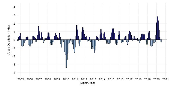 This graph shows monthly values for the Arctic Oscillation index. |
AO phases are analogous to the Southern Hemisphere's Antarctic Oscillation (AAO), a similar pattern of air pressure and jet stream anomalies in the Southern Hemisphere. Viewed from above either pole, these patterns show a characteristic ring shape or "annular" pattern; thus, AO and AAO are also referred to as the Northern Annular Mode (NAM) and Southern Annular Mode (SAM), respectively.
Monthly and Daily values for the Arctic Oscillation Index are available from NOAA's Climate Prediction Center.
Madden Julian Oscillation:
Climate Variability: Madden-Julian Oscillation (MJO)
Author: Jon Gottschalck
December 31, 2014
While the Madden-Julian Oscillation (MJO) is a lesser-known phenomenon, it can have dramatic impacts in the mid-latitudes. Several times a year the MJO is a strong contributor to various extreme events in the United States, including Arctic air outbreaks during the winter months across the central and eastern portions of the United States.
Imagine ENSO as a person riding a stationary exercise bike in the middle of a stage all day long. His unchanging location is associated with the persistent changes in tropical rainfall and winds that we have previously described as being linked to ENSO. Now imagine another bike rider entering the stage on the left and pedaling slowly across the stage, passing the stationary bike (ENSO), and exiting the stage at the right. This bike rider we will call the MJO and he/she may cross the stage from left to right several times during the show.
So, unlike ENSO, which is stationary, the MJO is an eastward-moving disturbance of clouds, rainfall, winds, and pressure that traverses the planet in the tropics and returns to its initial starting point in 30 to 60 days, on average. This atmospheric disturbance is distinct from ENSO, which once established, is associated with persistent features that last several seasons or longer over the Pacific Ocean basin. There can be multiple MJO events within a season, and so the MJO is best described as intraseasonal tropical climate variability (i.e. varies on a week-to-week basis).
The MJO was first discovered in the early 1970s by Dr. Roland Madden and Dr. Paul Julian when they were studying tropical wind and pressure patterns. They often noticed regular oscillations in winds (as defined by departures from average) between Singapore and Canton Island in the west-central equatorial Pacific (Madden and Julian, 1971; 1972; Zhang, 2005).
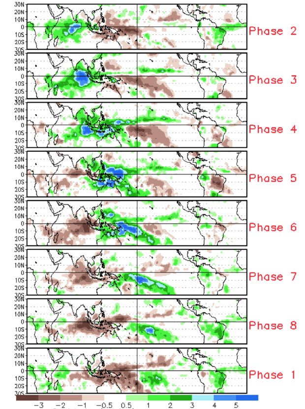
The MJO consists of two parts, or phases: one is the enhanced rainfall (or convective) phase and the other is the suppressed rainfall phase. Strong MJO activity often dissects the planet into halves: one half within the enhanced convective phase and the other half in the suppressed convective phase. These two phases produce opposite changes in clouds and rainfall and this entire dipole (i.e., having two main opposing centers of action) propagates eastward. The location of the convective phases is often grouped into geographically based stages that climate scientists number 1-8 as shown in Figure 1.
 |
||||||||
| Figure 1: Difference from average rainfall for all MJO events from 1979-2012 for November-March for the eight phases described in the text. The green shading denotes above-average rainfall, and the brown shading shows below-average rainfall. In first order, the green shading areas correspond to the extent of the enhanced convective phase of the MJO and the brown shading areas correspond to the extent of the suppressed convective phase of the MJO. Note the eastward shifting of shaded areas with each successive numbered phase as you view the figure from top to bottom. | ||||||||
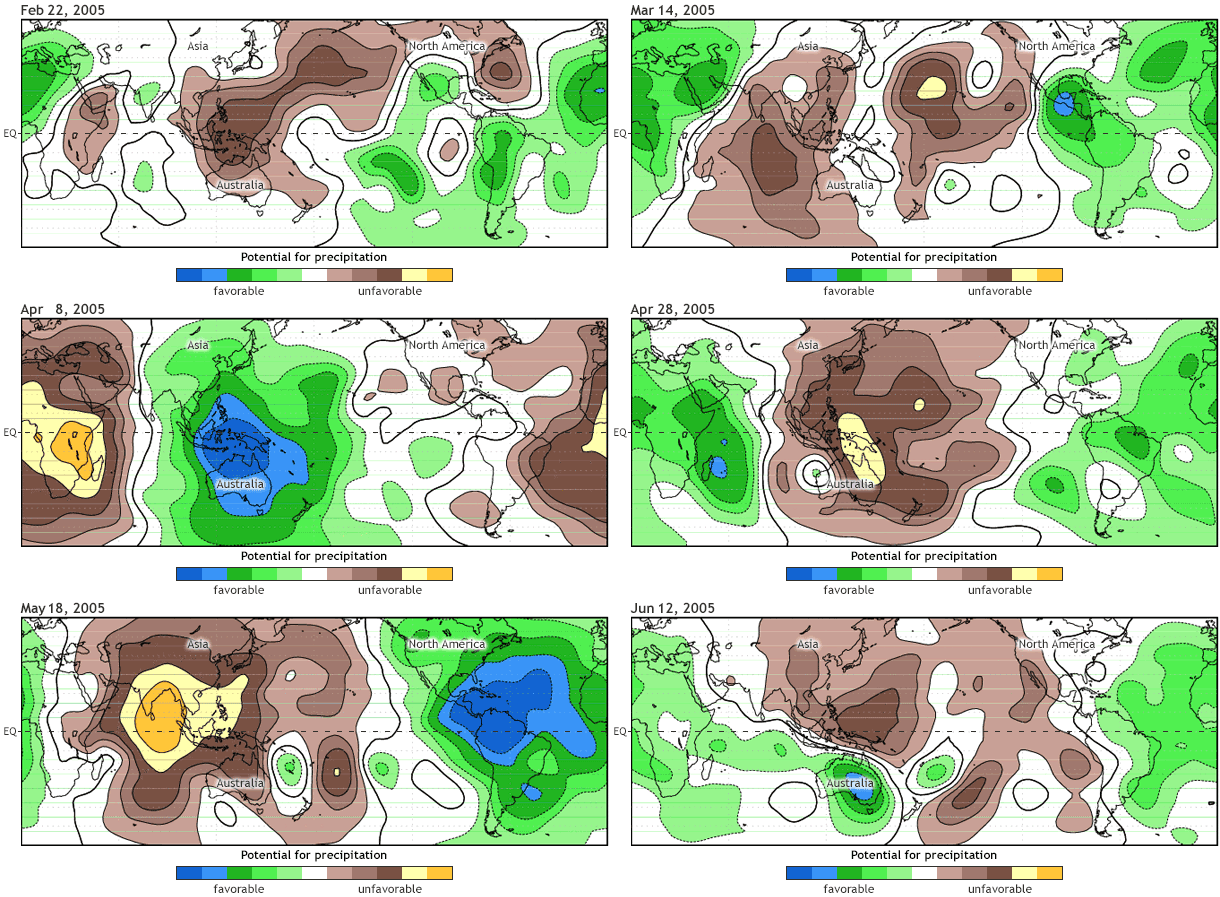
For the MJO to be considered active, this dipole of enhanced/suppressed convective phases must be present and shifting eastward with time. An animated illustration that depicts the global scale and eastward propagation of these two phases of the MJO is shown here (Fig. 2: animation).
 |
||||||||||
| Figure 2: An animation illustrating the organization of the MJO into its enhanced and suppressed convective phases during an MJO event during the spring of 2005. The green shading denotes conditions favorable for large-scale enhanced rainfall, and the brown shading shows conditions unfavorable for rainfall. The MJO becomes organized during late March through May as the green shading covers one half of the planet, and brown shades the other half all along as these areas move west to east with time. Notice how the shading returns to the same location on the order of about 45 days. | ||||||||||
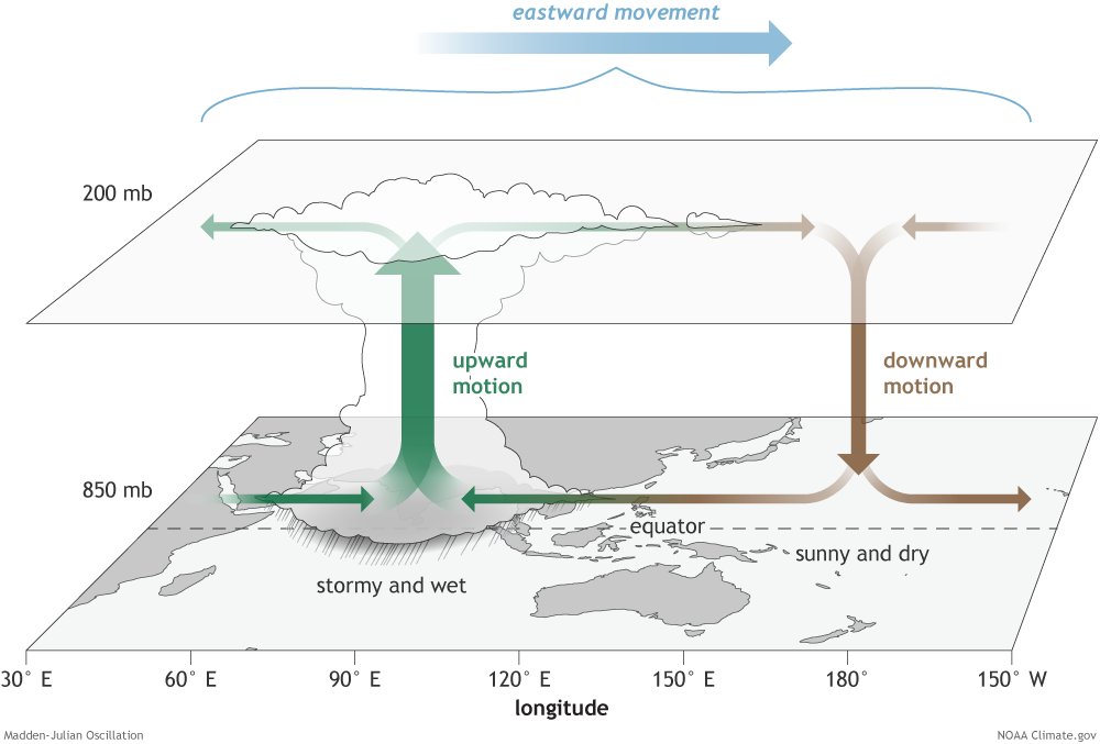
Let’s dig a little deeper and look at some of the characteristics within these two convective phases (Figure 3). In the enhanced convective phase, winds at the surface converge, and the air is pushed up throughout the atmosphere. At the top of the atmosphere, the winds reverse (i.e., diverge). Such rising air motion in the atmosphere tends to increase condensation and rainfall.
 |
||||||||||
| Figure 3: The surface and upper-atmosphere structure of the MJO for a period when the enhanced convective phase (thunderstorm cloud) is centered across the Indian Ocean and the suppressed convective phase is centered over the west-central Pacific Ocean. Horizontal arrows pointing left represent wind departures from average that are easterly, and arrows pointing right represent wind departures from average that are westerly. The entire system shifts eastward over time, eventually circling the globe and returning to its point of origin. Climate.gov drawing by Fiona Martin. | ||||||||||
In the suppressed convective phase, winds converge at the top of the atmosphere, forcing air to sink and, later, to diverge at the surface (Rui and Wang, 1990). As air sinks from high altitudes, it warms and dries, which suppresses rainfall.
It is this entire dipole structure, illustrated in Figure 3, that moves west to east with time in the Tropics, causing more cloudiness, rainfall, and even storminess in the enhanced convective phase, and more sunshine and dryness in the suppressed convective phase.
The changes in rainfall and winds described above impact both the Tropics and the Extratropics, which makes the MJO important for extended-range weather and climate prediction over the U.S. and many other areas. The MJO can modulate the timing and strength of monsoons (e.g., Jones and Carvalho, 2002; Lavender and Matthews, 2009), influence tropical cyclone numbers and strength in nearly all ocean basins (e.g., Maloney and Hartmann, 2000), and result in jet stream changes that can lead to cold air outbreaks, extreme heat events, and flooding rains over the United States and North America (Higgins et al. 2000, Cassou, 2008, Lin et al. 2009, Zhou et al., 2012, Riddle et al., 2013, Johnson et al., 2014).
The MJO can produce impacts similar to those of ENSO, but which appear only in weekly averages before changing, rather than persisting and therefore appearing in seasonal averages as is the case for ENSO.
Future posts will focus on the details of how we monitor and assess the strength of the MJO, provide details on impacts and the reasons for those impacts, and describe the current state of MJO predictability. Real-time MJO information that is updated daily or weekly can be found on the NOAA CPC MJO webpage.
North Atlantic Oscillation:
Climate Variability: North Atlantic Oscillation (NAO)
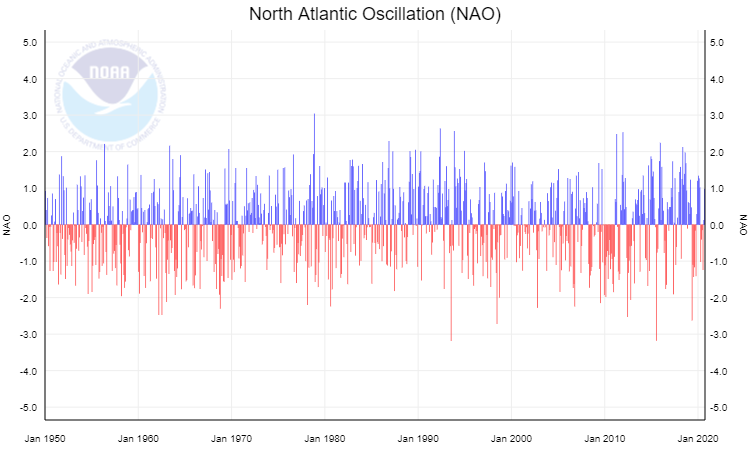
The North Atlantic Oscillation (NAO) index is based on the surface sea-level pressure difference between the Subtropical (Azores) High and the Subpolar Low. The positive phase of the NAO reflects below-normal heights and pressure across the high latitudes of the North Atlantic and above-normal heights and pressure over the central North Atlantic, the eastern United States, and western Europe. The negative phase reflects an opposite pattern of height and pressure anomalies over these regions. Both phases of the NAO are associated with basin-wide changes in the intensity and location of the North Atlantic jet stream and storm track, and in large-scale modulations of the normal patterns of zonal and meridional heat and moisture transport, which in turn results in changes in temperature and precipitation patterns often extending from eastern North America to western and central Europe.
During particularly prolonged periods dominated by one particular phase of the NAO, abnormal height and temperature patterns are also often seen extending well into central Russia and north-central Siberia.
The NAO exhibits considerable interseasonal and interannual variability, and prolonged periods (several months) of both positive and negative phases of the pattern are common.
The NAO index is obtained by projecting the NAO loading pattern to the daily anomaly 500 millibar height field over 0-90°N. The NAO loading pattern has been chosen as the first mode of a Rotated Empirical Orthogonal Function (EOF) analysis using monthly mean 500 millibar height anomaly data from 1950 to 2000 over 0-90°N latitude.
 |
For more information, please visit the NCEI and Climate Prediction Center NAO pages.
Quasi-Biennial Oscillation:
Climate Variability: Quasi-Biennial Oscillation (QBO)
The Quasi-Biennial Oscillation (QBO) is a regular, periodic reversal of the wind direction in the tropical stratosphere—alternating between easterly (from the east) and westerly (from the west)—that completes a full cycle in an average of 28 months (roughly every 2 years).
Key Features of the QBO
How the QBO Affects Global Climate?
 |
You can track historical and monthly data through resources like the NOAA Physical Sciences Laboratory QBO Timeseries or read breakdown analyses on NOAA Climate.gov.
For more information, please visit the NCEI and Climate Prediction Center NAO pages.
Past Winters:
Below are the temperature, precipitation, and snow data for La Crosse, WI, and Rochester, MN.
|
|
||||||||||||||||||||||||||||||||||||||||||||||||||||||||||||||||||||||||||||||||||||||||||||||||||||||||||||||||||||||||||||||||||||||||||||||||||||||||||||||||||||||||||||||||||||||||||||||||||||||||||||||||||||||||||||||||||||||||||||||||||||||||||||||||||||||||||||||||||||||||||||||||||||||||||||||||||||||||||||||||||||||||||||||||||||||||||||||||||||||||||||||||||||||||||||||||||||||||||||||||||||||||||||||||||||||||||||||||||||||||||||||||||||||||||||||||||||||||||||||||||||||||||||||||||||||||||||||||||||||||||||||||||||||||||||||||||||||||||||||||||||||||||||||||||||||||||||||||||||||||||||||||||||||||||||||||||||||||||||||||||||||||||||||||||||||||||||||||||||||||||||||||||||||||||||||||||||||||||||||||||||||||||||||||||||||||||||||||||||||||||||||||||||||||||||||||||||||||||||||||||||||||||||||||||||||||||||||||||||||||||||||||||||||||||||||||||||||||||||||||||||||||||||||||||||||||||||||||||||||||||||||||||||||||||||||||||||||||||||||||||||||||||||||||||||||||||||||||||||||
|
|||||||||||||||||||||||||||||||||||||||||||||||||||||||||||||||||||||||||||||||||||||||||||||||||||||||||||||||||||||||||||||||||||||||||||||||||||||||||||||||||||||||||||||||||||||||||||||||||||||||||||||||||||||||||||||||||||||||||||||||||||||||||||||||||||||||||||||||||||||||||||||||||||||||||||||||||||||||||||||||||||||||||||||||||||||||||||||||||||||||||||||||||||||||||||||||||||||||||||||||||||||||||||||||||||||||||||||||||||||||||||||||||||||||||||||||||||||||||||||||||||||||||||||||||||||||||||||||||||||||||||||||||||||||||||||||||||||||||||||||||||||||||||||||||||||||||||||||||||||||||||||||||||||||||||||||||||||||||||||||||||||||||||||||||||||||||||||||||||||||||||||||||||||||||||||||||||||||||||||||||||||||||||||||||||||||||||||||||||||||||||||||||||||||||||||||||||||||||||||||||||||||||||||||||||||||||||||||||||||||||||||||||||||||||||||||||||||||||||||||||||||||||||||||||||||||||||||||||||||||||||||||||||||||||||||||||||||||||||||||||||||||||||||||||||||||||||||||||||||||
|
|
||||||||||||||||||||||||||||||||||||||||||||||||||||||||||||||||||||||||||||||||||||||||||||||||||||||||||||||||||||||||||||||||||||||||||||||||||||||||||||||||||||||||||||||||||||||||||||||||||||||||||||||||||||||||||||||||||||||||||||||||||||||||||||||||||||||||||||||||||||||||||||||||||||||||||||||||||||||||||||||||||||||||||||||||||||||||||||||||||||||||||||||||||||||||||||||||||||||||||||||||||||||||||||||||||||||||||||||||||||||||||||||||||||||||||||||||||||||||||||||||||||||||||||||||||||||||||||||||||||||||||||||||||||||||||||||||||||||||||||||||||||||||||||||||||||||||||||||||||||||||||||||||||||||||||||||||||||||||||||||||||||||||||||||||||||||||||||||||||||||||||||||||||||||||||||||||||||||||||||||||||||||||||||||||||||||||||||||||||||||||||||||||||||||||||||||||||||||||||||||||||||||||||||||||||||||||||||||||||||||||||||||||||||||||||||||||||||||||||||||||||||||||||||||||||||||||||||||||||||||||||||||||||||||||||||||||||||||||||||||||||||||||||||||||||||||||||||||||||||||
|
|||||||||||||||||||||||||||||||||||||||||||||||||||||||||||||||||||||||||||||||||||||||||||||||||||||||||||||||||||||||||||||||||||||||||||||||||||||||||||||||||||||||||||||||||||||||||||||||||||||||||||||||||||||||||||||||||||||||||||||||||||||||||||||||||||||||||||||||||||||||||||||||||||||||||||||||||||||||||||||||||||||||||||||||||||||||||||||||||||||||||||||||||||||||||||||||||||||||||||||||||||||||||||||||||||||||||||||||||||||||||||||||||||||||||||||||||||||||||||||||||||||||||||||||||||||||||||||||||||||||||||||||||||||||||||||||||||||||||||||||||||||||||||||||||||||||||||||||||||||||||||||||||||||||||||||||||||||||||||||||||||||||||||||||||||||||||||||||||||||||||||||||||||||||||||||||||||||||||||||||||||||||||||||||||||||||||||||||||||||||||||||||||||||||||||||||||||||||||||||||||||||||||||||||||||||||||||||||||||||||||||||||||||||||||||||||||||||||||||||||||||||||||||||||||||||||||||||||||||||||||||||||||||||||||||||||||||||||||||||||||||||||||||||||||||||||||||||||||||||||
| Caption (source) |
Caption (source) |
Caption (source) |
Caption (source) |
 |
Media use of NWS Web News Stories is encouraged! Please acknowledge the NWS as the source of any news information accessed from this site. |
|



 Weather Story
 Weather Map
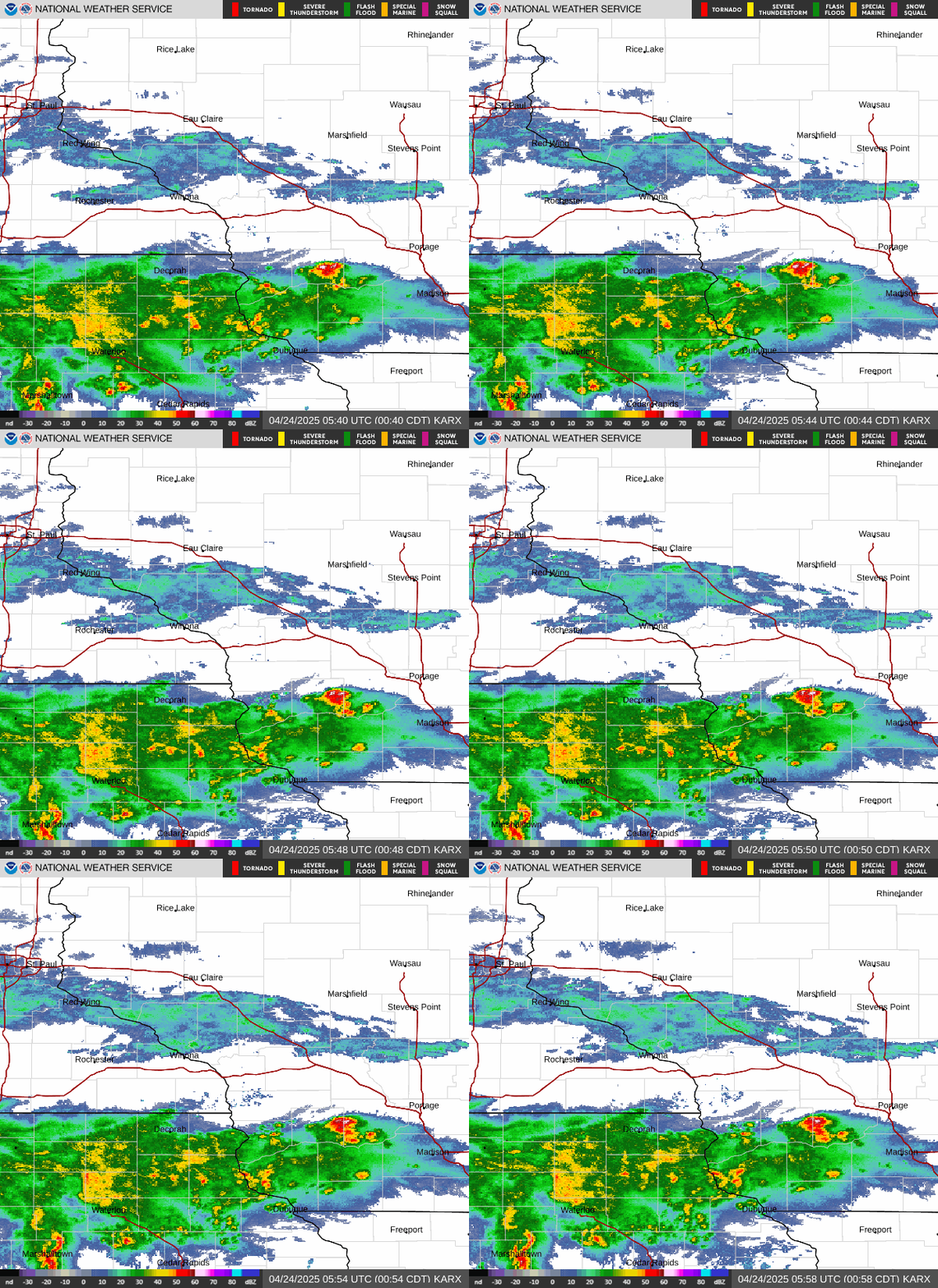 Local Radar
 Follow us on X
 Follow us on Facebook
 Follow us on YouTube
 ARX RSS Feed
![[Fig. 1]](https://www.cpc.ncep.noaa.gov/products/analysis_monitoring/enso_advisory/figure01.gif)
![[Fig. 2]](https://www.cpc.ncep.noaa.gov/products/analysis_monitoring/enso_advisory/figure02.gif)
![[Fig. 3]](https://www.cpc.ncep.noaa.gov/products/analysis_monitoring/enso_advisory/figure03.gif)
![[Fig. 4]](https://www.cpc.ncep.noaa.gov/products/analysis_monitoring/enso_advisory/figure04.gif)
![[Fig. 5]](https://www.cpc.ncep.noaa.gov/products/analysis_monitoring/enso_advisory/figure05.gif)
![-8]](https://www.cpc.ncep.noaa.gov/products/analysis_monitoring/enso_advisory/figure08.gif)