Life-threatening and locally catastrophic flash and urban flooding is expected across portions of south-central Texas through early Friday, with significant river flooding and rapid rises on small streams, arroyos, and typically dry washes expected. A significant heat wave continues for the Rockies, Northern Plains, and Great Lakes into the Mid-Atlantic, peaking in intensity through midweek. Read More >
Overview
|
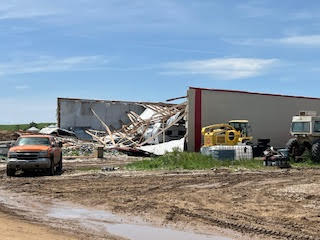
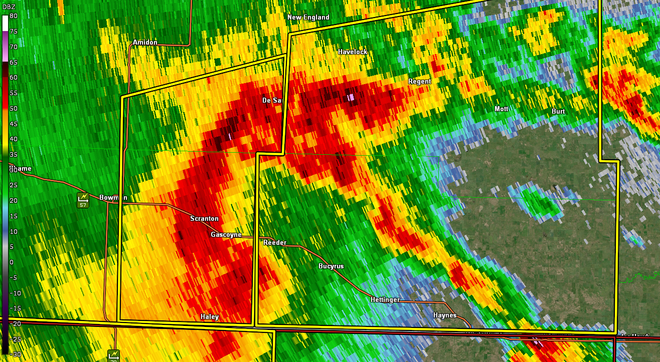
A strong storm system moving across the northern High Plains started to approach western North Dakota late Sunday night (June 15, 2025). A Severe Thunderstorm Watch was issued at 9:55 PM MDT / 10:55 PM CDT as a cluster of severe storms started to move in from eastern Montana. A couple of initial storms produced severe hail across far northwest North Dakota up to half dollar size, but the most significant severe weather came in the form of damaging winds across southwest North Dakota early Monday morning (June 16, 2025). An NDAWN station located 1 mile west northwest of Hettinger (Adams County) reported a 94 mph wind gust and another site recorded a 92 mph gust 2 miles north of Bentley in Hettinger County. Significant straight line wind damage was also reported as the storms moved quickly across the southwest and south central through the early morning hours. Several other gusts ranging from 59 mph to 74 mph were recorded as storms moved further east. Finally, widespread rainfall amounts ranging from an inch to just over 3 inches were reported as the storm complex moved through. |
|
Wind
 |
 |
 |
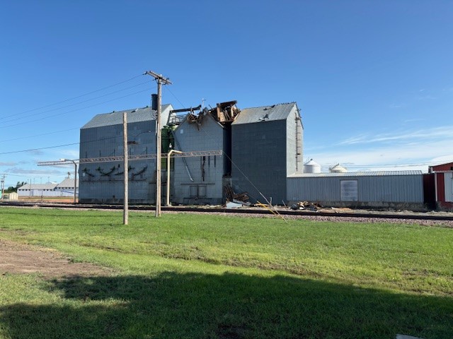 |
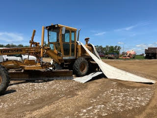
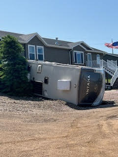
| 6 South of Reeder, Photo Courtesy of Michele Gaylord | 2 West of Hettinger, Photo Courtesy of Chris Feller | 2 West of Hettinger, Photo Courtesy of Chris Feller | Bowman, Photo Courtesy of Dean Pearson |
 |
 |
 |
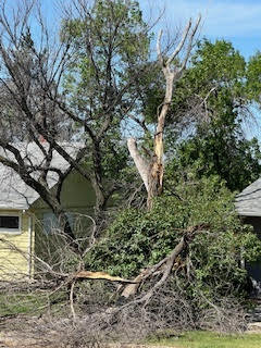 |
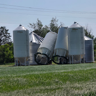
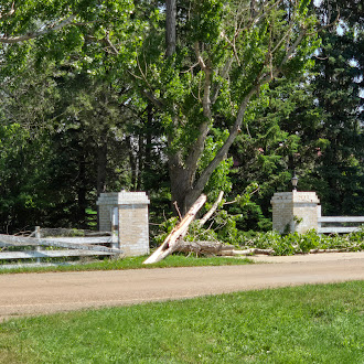
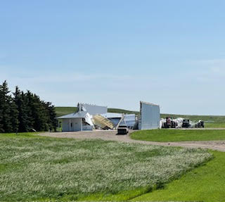
| Bowman, Photo Courtesy of Dean Pearson | 2 South of Hettinger, Photo Courtesy of Michele Gaylord | Hettinger, Photo Courtesy of Michele Gaylord | Hettinger, Photo Courtesy of Michele Gaylord |
Rain Reports
Location                     Amount    Time/Date
6 NNW New Hradec             3.04 in   0845 AM 06/16
5 NNW Regan                  2.88 in   0813 AM 06/16
Wilton                       2.54 in   0801 AM 06/16
Carson                       2.35 in   0749 AM 06/16
9 NNW New Leipzig            2.20 in   0840 AM 06/16
2 NNE Hirschville            2.09 in   0840 AM 06/16
12 N Reeder                  1.92 in   0845 AM 06/16
1 NNE Amidon                 1.79 in   0840 AM 06/16
11 NNE Scranton              1.78 in   0847 AM 06/16
3 ESE Griffin                1.77 in   0835 AM 06/16
4 NNW Fortuna                1.76 in   0835 AM 06/16
Rhame 1.9 E                  1.75 in   0750 AM 06/16
2 E Rhame                    1.75 in   0754 AM 06/16
2 NNW Marmarth               1.73 in   0857 AM 06/16
5 SW Judson                  1.69 in   0840 AM 06/16
1 SSE Sanger                 1.62 in   0843 AM 06/16
9 W Manning                  1.60 in   0840 AM 06/16
10 NNE Sentinel Butte        1.59 in   0845 AM 06/16
Hurdsfield                   1.59 in   0845 AM 06/16
1 NNE Mott                   1.57 in   0845 AM 06/16
Dickinson Airport            1.55 in   0756 AM 06/16
1 ESE Lark                   1.51 in   0845 AM 06/16
9 NNW Wing                   1.51 in   0850 AM 06/16
7 NW Streeter                1.41 in   1240 PM 06/16
4 NNE Golva                  1.39 in   0850 AM 06/16
2 NW Dickinson               1.39 in   0850 AM 06/16
7 W Venturia                 1.38 in   0850 AM 06/16
Halliday 2.4 N               1.30 in   0800 AM 06/16
8 NE Dunn Center             1.27 in   0850 AM 06/16
Killdeer 5.4 SW              1.26 in   0640 AM 06/16
5 W New England              1.25 in   0855 AM 06/16
Wishek 0.2 WNW               1.20 in   0700 AM 06/16
1 NE Denhoff                 1.18 in   0855 AM 06/16
Hebron 11.2 NE               1.16 in   0600 AM 06/16
Manning 1.3 NE               1.15 in   0730 AM 06/16
5 SE Johnsons Corner         1.13 in   0855 AM 06/16
10 NNE Dunn Center           1.10 in   0900 AM 06/16
4 W Fryburg                  1.08 in   0855 AM 06/16
Edgeley 5.2 NW               1.03 in   0800 AM 06/16
Kulm 4.0 NNE                 1.02 in   0800 AM 06/16
7 SSW Hebron                 1.02 in   0855 AM 06/16
10 SE Lefor                  1.02 in   0855 AM 06/16
5 SE Buchanan                1.00 in   0740 AM 06/16
7 SSW Fryburg                1.00 in   0900 AM 06/16
Storm Reports
...HIGHEST WIND REPORTS...

Location                     Speed     Time/Date
1 WNW Hettinger              94 MPH    0115 AM 06/16
2 N Bentley                  92 MPH    0215 AM 06/16
8 N Selfridge                74 MPH    0240 AM 06/16
2 E Rhame                    70 MPH    0215 AM 06/16
15 SSW Leith                 64 MPH    0200 AM 06/16
3 WSW Buffalo Springs        64 MPH    0256 AM 06/16
5 W Wishek                   64 MPH    0344 AM 06/16
3 ESE Griffin                63 MPH    0253 AM 06/16
9 NW Williston               62 MPH    1149 PM 06/15
1 SSW Crosby                 60 MPH    0801 PM 06/15
15 SSW Leith                 60 MPH    0159 AM 06/16
11 NNE Scranton              59 MPH    0104 AM 06/16
4 SE Griffin                 57 MPH    1232 AM 06/16
9 NNW New Leipzig            57 MPH    0233 AM 06/16
3 SSW Temvik                 56 MPH    0318 AM 06/16
...HAIL REPORTS...

Location                     Size      Time/Date
7 NW Fortuna                 1.25 in   0715 PM 06/15
5 SSW Larson                 1.00 in   0848 PM 06/15
Radar
 |
 |
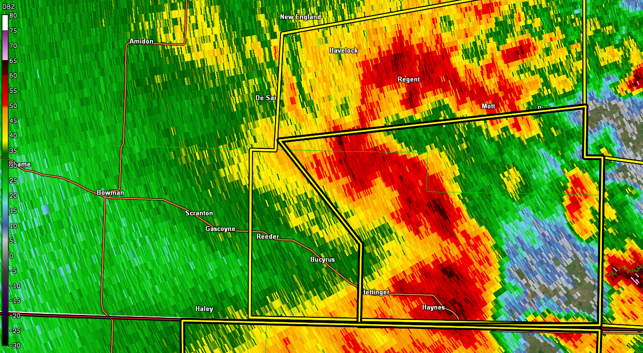 |
| 11:58 PM MDT, Significant Damage Occurring South of Reeder | 12:14 AM MDT, Significant Wind Gusts Occurring in and Around Hettinger | 12:32 AM MDT |
 |
Media use of NWS Web News Stories is encouraged! Please acknowledge the NWS as the source of any news information accessed from this site. |
|