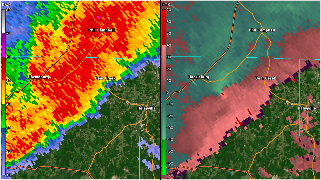
National Weather Service United States Department of Commerce


Tornadoes of April 1, 2023

Overview
 

Severe thunderstorms from late on March 31 to early on April 1 resulted in damage in the northern part of Central Alabama. This particular event affected several states and produced several strong tornadoes. Perhaps the hardest hit areas were central and eastern Arkansas (particularly Little Rock and Wynne), West Tennessee, and northern Mississippi. Below are links to additional NWS storm survey information from this tornado outbreak.

 
Interactive Damage Map


**The data below are considered PRELIMINARY.**

Location/Clickable Detailed Summary Link
Damage Rating/Estimated Maximum Wind Speeds
Injuries/Fatalities
Damage Path Length/Width
Starting Point/Time
Ending Point/Time
Marion/Winston Tornado
(Marion/Winston Counties)
EF-1
110 mph
1 Injury 17.05 miles
675 yards
3 SSW Hackleburg
34.2379/-87.8510
2:32 am CDT
1 SSW Pebble
34.2658/-87.5563
2:52 am CDT
Sardis City Tornado
(Etowah County)
EF-0
85 mph

 
2 Injuries 3.10 miles
250 yards
1 SSE Boaz
34.1805/-86.1494
4:51 am CDT
2 ENE Sardis City
34.1829/-86.0957
4:55 am CDT
 
Marion/Winston EF-1
 

Marion/Winston EF-1 Tornado (Marion & Winston Counties)
  April 1, 2023


Event Summary

EF-1
Estimated Maximum Wind:
110 mph
Injuries/Fatalities:
1 Injury
Damage Path Length:
17.05 miles
Maximum Path Width:
675 yards
Approximate Start Point/Time:
3 SSW Hackleburg
34.2379/-87.8510
at 2:32 am CDT
Approximate End Point/Time:
1 SSW Pebble
34.2658/-87.5563
at 2:52 am CDT


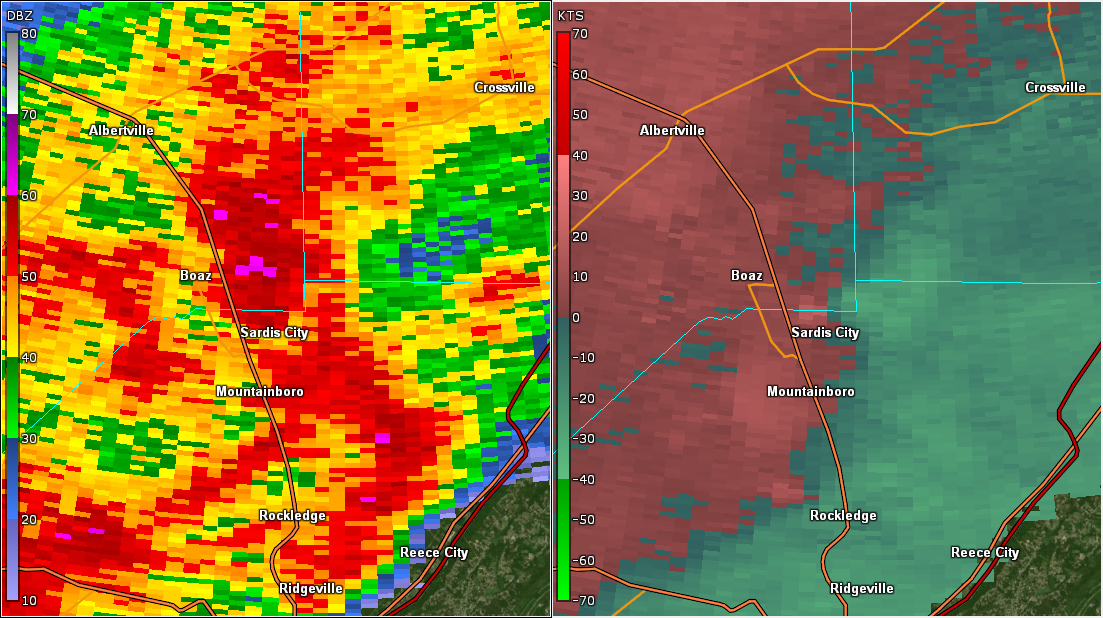
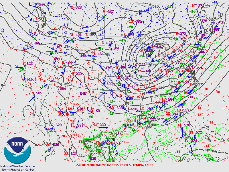
NWS personnel have surveyed the damage in Marion and Winston Counties and determined that the damage was caused by an EF1 tornado with maximum wind speeds of 110 mph.

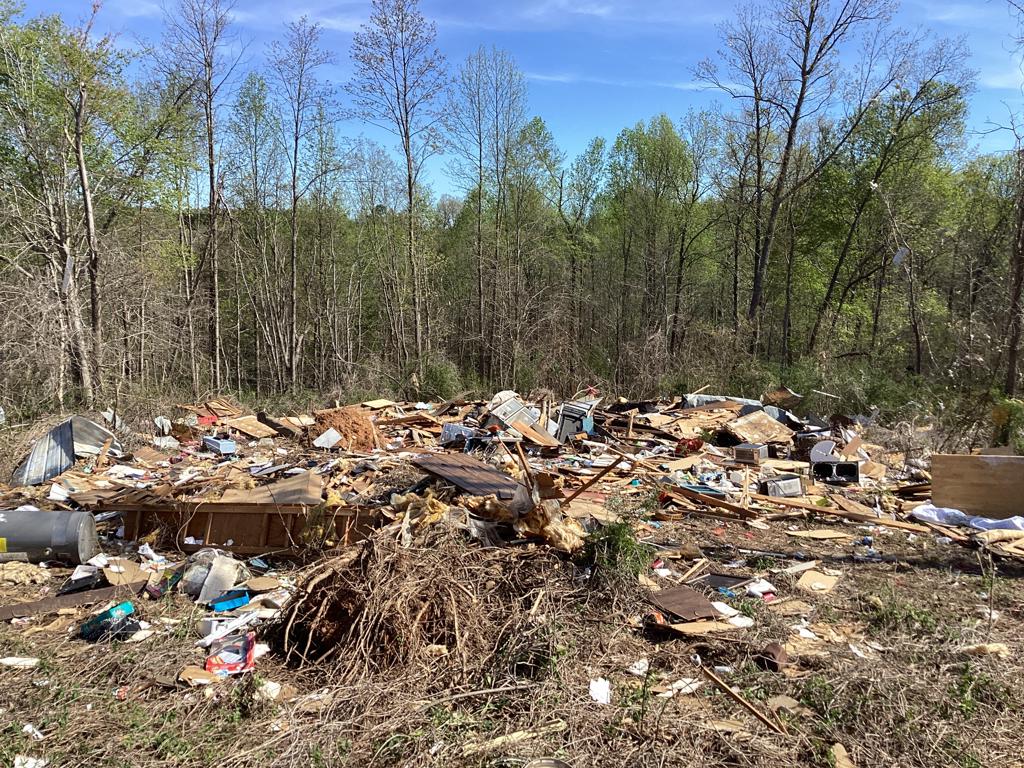
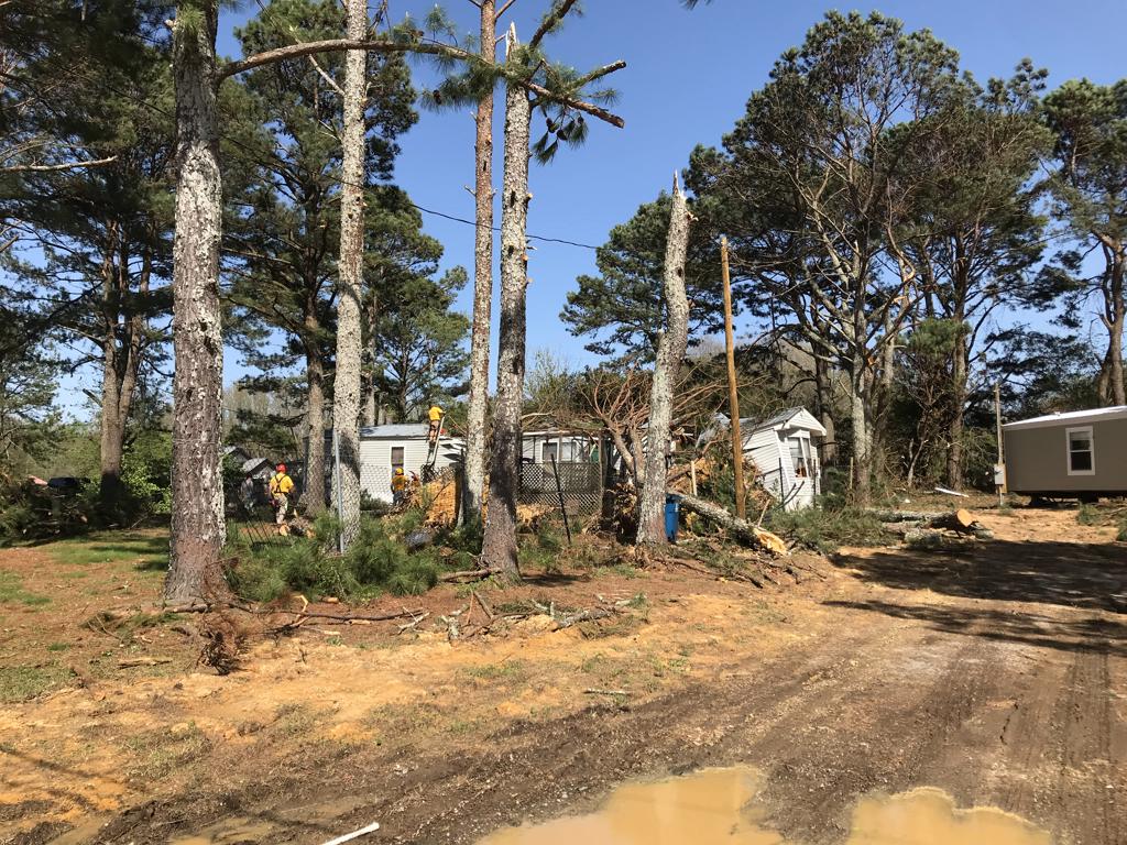
The tornado began on Marion County Road 348 west of AL Highway 253 south of Hackleburg, where minor tree damage was noted. The tornado rapidly increased and caused significant damage as it crossed AL Hwy 253, uprooting several trees and causing superficial damage to a home on the edge of the track. The tornado continued east-northeastward along Union Hill Road, crossing the twisting road twice before the intersection with Chalk Mine Road. Damage in this segment of the path consisted solely of pockets of tree damage which varied in intensity but was easily identified as tornado damage. As the tornado paralleled Chalk Mine Road, it produced more widespread tree damage, and destroyed a manufactured home that was exposed on a knob of a hill. The damage to trees surrounding the manufactured home was minimal, which contributed to a below expected value or 100 mph assigned to the flipping and tossing of the home. The tornado continued across the Fairview community causing significant tree damage just east of County Road 12, with a grove of pine trees all being sheared off about 20 feet above ground level. The tornado then continued over inaccessible areas south of County Road 6 as it headed towards the Lumbull community, crossing Alabama Highway 241 just south of Lumbull. As it approached Bear Creek, it continued to cause sparse but notable tree damage.

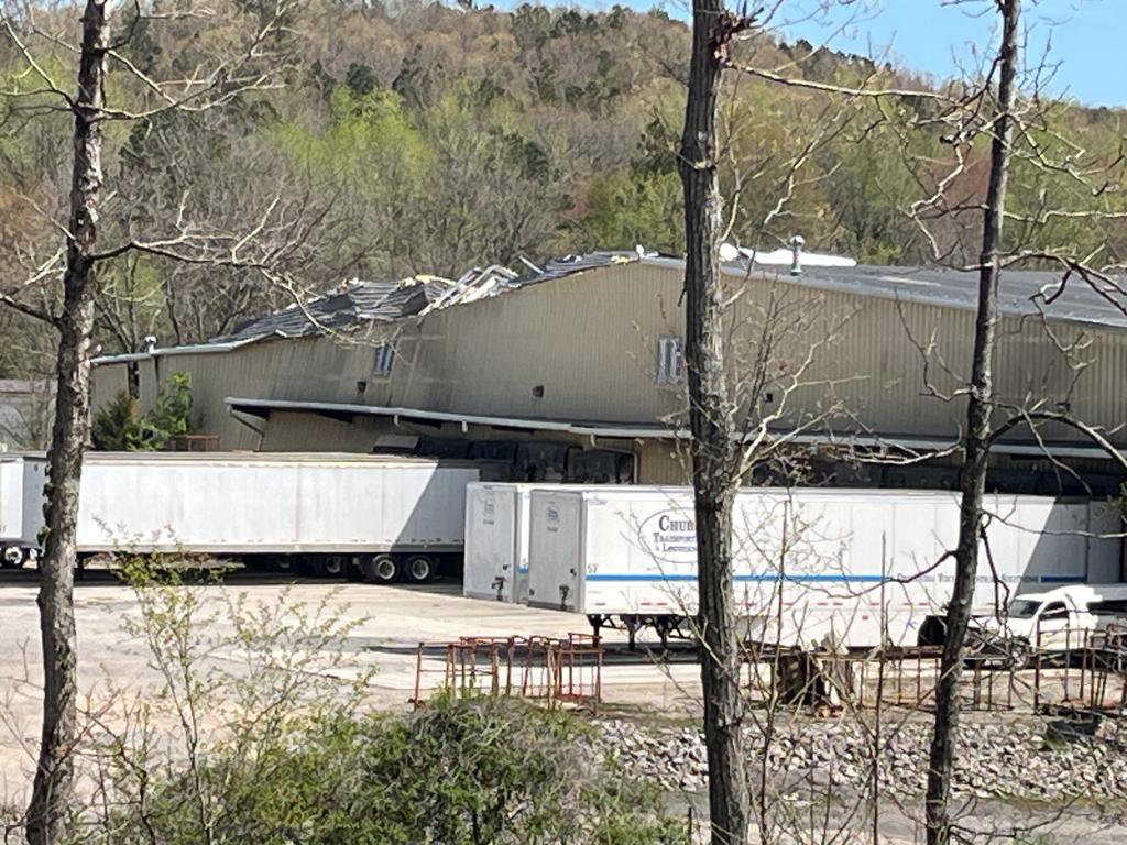
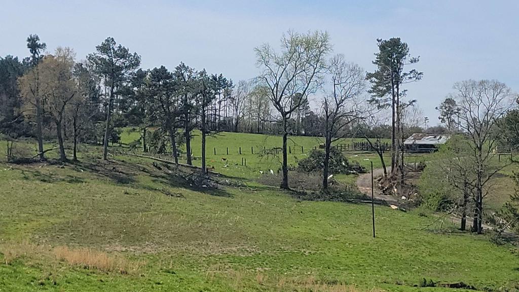
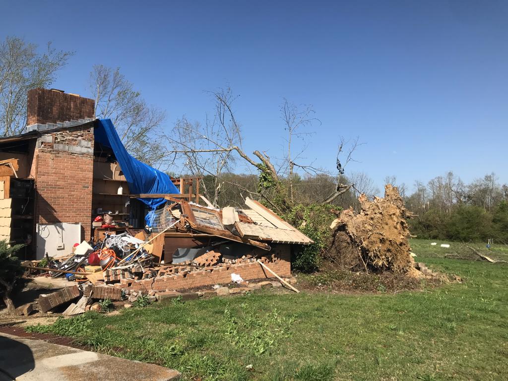
The most significant damage along the entire path occurred along Alabama Highway 13 south of Bear Creek, where a large metal building structure received significant damage to the windward side of the building. Winds in this area approached 110 mph, bringing this tornado to a high end EF-1 tornado. The tornado then crossed AL Hwy 13, where an individual received major injuries as the manufactured home being occupied was flipped upside-down. The tornado continued eastward, crossing Old Union Road, then paralleling County Line Church Road until the tornado passed into Winston County, snapping and uprooting trees in a continuous but sparse pattern. A few homes and outbuildings were affected either by minor wind damage or trees falling on them. The tornado weakened somewhat as it crossed the county line, and the damage path widened. As it approached the vicinity of Posey Field, the tornado seemed to intensify locally, uprooting several trees in a residential neighborhood. The tornado crossed Airport Road, damaging trees and a detached garage at a residence. The tornado continued eastward through the Center community, with damage decreasing and becoming more sporadic before eventually dissipating just north of County Road 68 just west of Alabama Highway 195 


Radar Image
Reflectivity (left) and velocity (right) as the tornado passed through the Brush Creek Hollow area.
Images are from KGWX at 2:37 am CDT.


Damage Photo
 Manufactured Home Destroyed
Damage Photo
 Structural Damage to Kith Furniture
Damage Photo
 Timber & Structural Damage
 
Sardis City EF-0
 

Sardis City EF-0 Tornado (Etowah County)
  April 1, 2023


Event Summary

EF-0
Estimated Maximum Wind:
85 mph
Injuries/Fatalities:
2 Inuries
Damage Path Length:
3.10 miles
Maximum Path Width:
250 yards
Approximate Start Point/Time:
1 SSE Boaz
34.1805/-86.1494
at 4:51 am CDT
Approximate End Point/Time:
2 ENE Sardis City
34.1829/-86.0957
at 4:55 am CST


A damage survey conducted in the Sardis City area of northern Etowah County revealed an EF0 tornado that occurred on the morning of April 1.

The damage path began with an uprooted tree along Coosa Road before moving across Highway 431, where a shop had large doors blown out and a church had the roof partially removed. At Morningview Drive and Hood Drive, several homes had significant roof damage and numerous trees were uprooted. A shed was blown several yards and destroyed, a fence was blown down, and one home had failure of the west facing garage door which caused the roof to be removed and walls to collapse. More trees were downed in a wooded area before the tornado moved along Patterson Street. Here, one home sustained roof damage, a silo was damaged, a metal shed had significant damage to the southeast corner, and a tree fell through another home`s backyard privacy fence. Many hundred-year-old trees were uprooted around both homes. Another home was damaged by a falling tree at the corner of Patterson and Church Road. More trees were downed across Parkway Drive and Alexander Drive. Two pine trees fell through two mobile homes on Alexander Drive. Two people were injured in one of the mobile homes. A few more pine trees were uprooted, with smaller limbs snapped off as well, across Kristie Lane and Oak Drive. At Horton Circle, numerous trees were uprooted, and a house sustained minor shingle damage. The damage path ended after crossing Broadwell Road near the Sardis Drive intersection.


Radar Image
Reflectivity (left) and velocity (right) of the tornado.
Images are from KHUN at 4:53 am CDT.


Damage Photo
 Structural Damage
Damage Photo
 Structural Damage
 
Outlooks & Reports
 

Local Day 3 Outlook
Local Day 3 Outlook
Mar 29 at 430 am

Local Day 2 Outlook
Local Day 2 Outlook
Mar 30 at 415 am

Local Day 1 Outlook
Local Day 1 Outlook
Mar 31 at 330 pm

Storm Reports
Storm Reports
Thru 7 AM on April 1


Surface & Upper Air Charts
 

250mb Analysis
250mb Analysis
Mar 31 at 7 pm

500mb Analysis
500mb Analysis
Mar 31 at 7 pm

850mb Analysis
850mb Analysis
Mar 31 at 7 pm

250mb Analysis
250mb Analysis
Apr 1 at 7 am

500mb Analysis
500mb Analysis
Apr 1 at 7 am

850mb Analysis
850mb Analysis
Apr 1 at 7 am

KBMX Sounding
KBMX Sounding
Apr 1 at 1 am

Surface Chart
Surface Analysis
Mar 31 at 10 pm

Surface Analysis
Surface Analysis
Apr 1 at 1 am

Surface Analysis
Surface Analysis
Apr 1 at 4 am

Surface Analysis
Surface Analysis
Apr 1 at 7 am