|
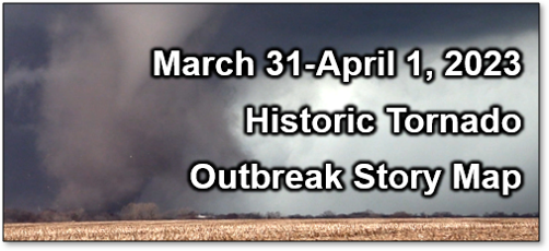
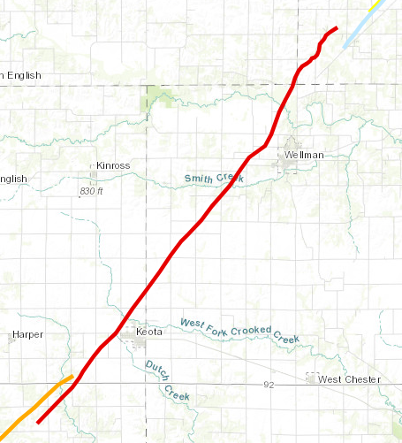
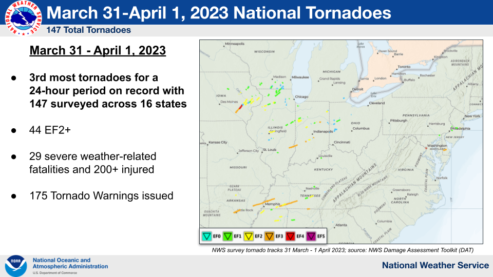
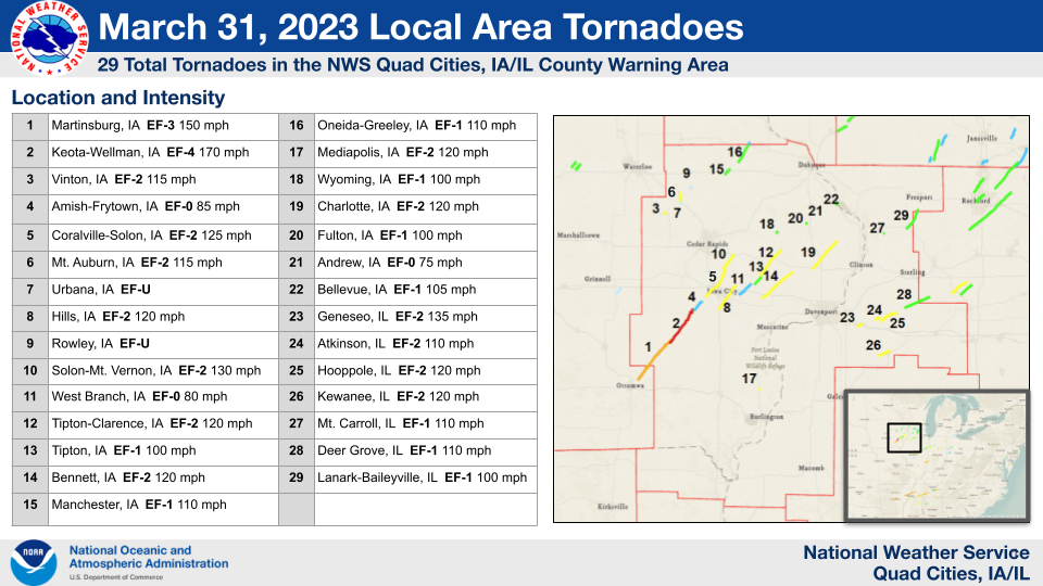
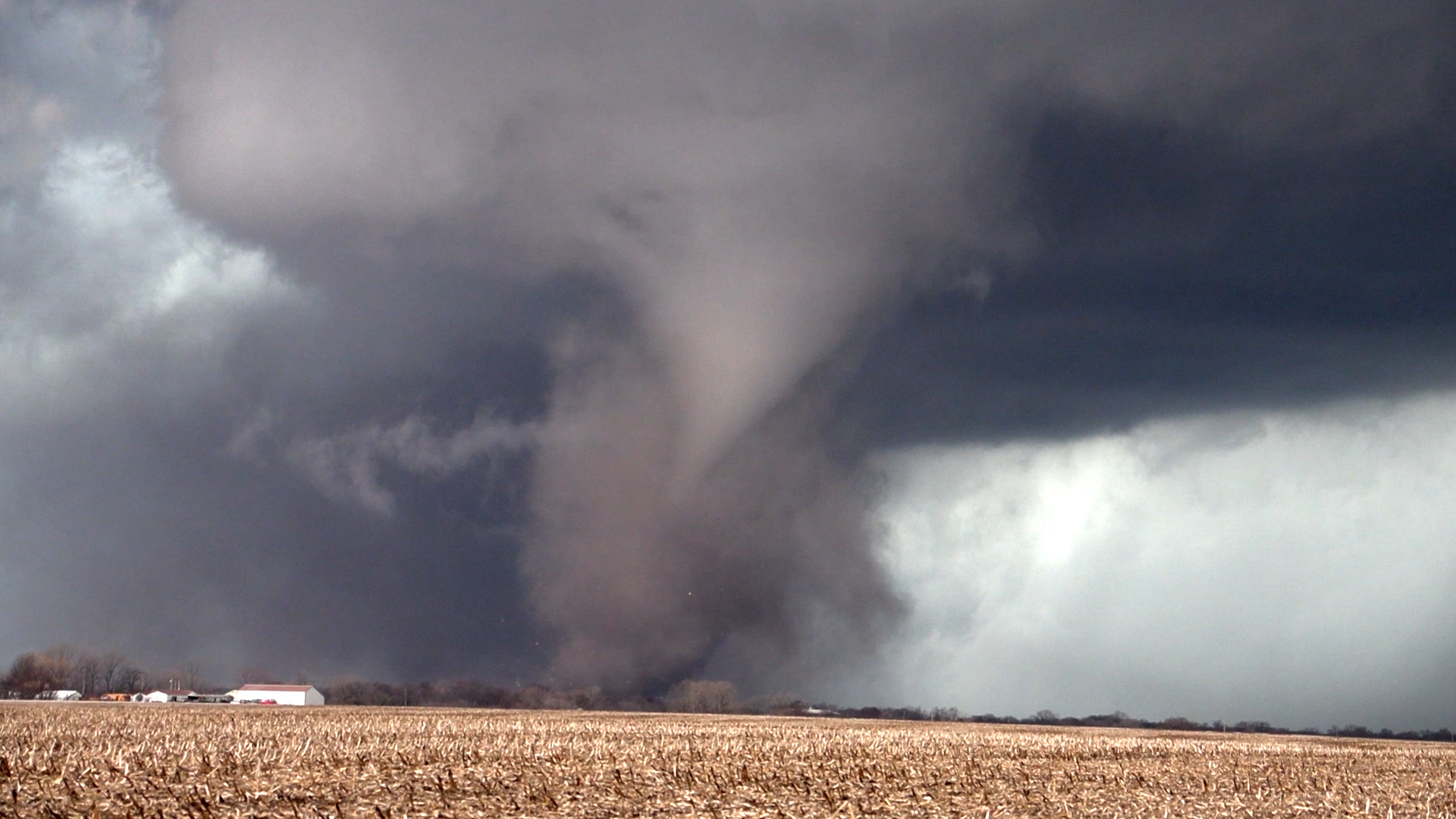
Overview A widespread tornado outbreak occurred Friday, March 31, 2023 involving nearly 150 tornadoes across the country. This included 29 tornadoes in the NWS Quad Cities County Warning Area (CWA), with eleven (11) reported injuries, and no fatalities. This was one of the nation's largest tornado outbreaks in terms of total number of tornadoes, and was the largest tornado outbreak in the NWS Quad Cities CWA on record (since 1950). The strongest tornado developed southwest of Keota, IA and moved northeast towards Wellman before finally dissipating in far southwestern Johnson county. It was rated EF4 with maximum sustained winds estimated around 170 mph. This was the strongest tornado in the NWS Quad Cities CWA since 1995. |
|
Tornado Totals:
 |
 |
||
| National Tornadoes on March 31-April 1, 2023 | NWS Quad Cities County Warning Area Tornadoes on March 31, 2023 |
Damage Assessment Toolkit Viewer
Damage including Tornado Tracks KMZ File for in/near DVN CWA
Damage including Tornado Tracks Shapefile for in/near DVN CWA
| NWS Quad Cities CWA Statistics | |||||
| Tornadoes: 29 Injuries: 11 Fatalities: 0 | |||||
| EFU UNKN |
EF0 Weak 65-85 mph |
EF1 Moderate 86-110 mph |
EF2 Significant 111-135 mph |
EF3 Severe 136-165 mph |
EF4 Extreme 166-200 mph |
| 2 | 3 | 9 | 13 | 1 | 1 |
| EF Scale | |||||
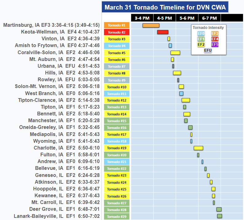 |
| Timeline of Tornadoes in the NWS Quad Cities CWA on March 31, 2023 |
Photos & Video
 |
 |
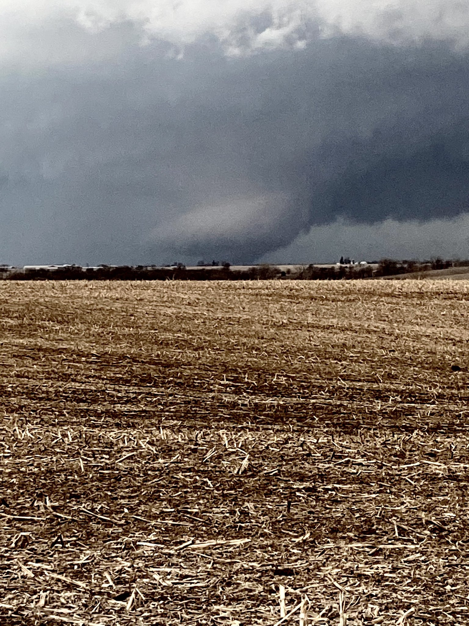 |
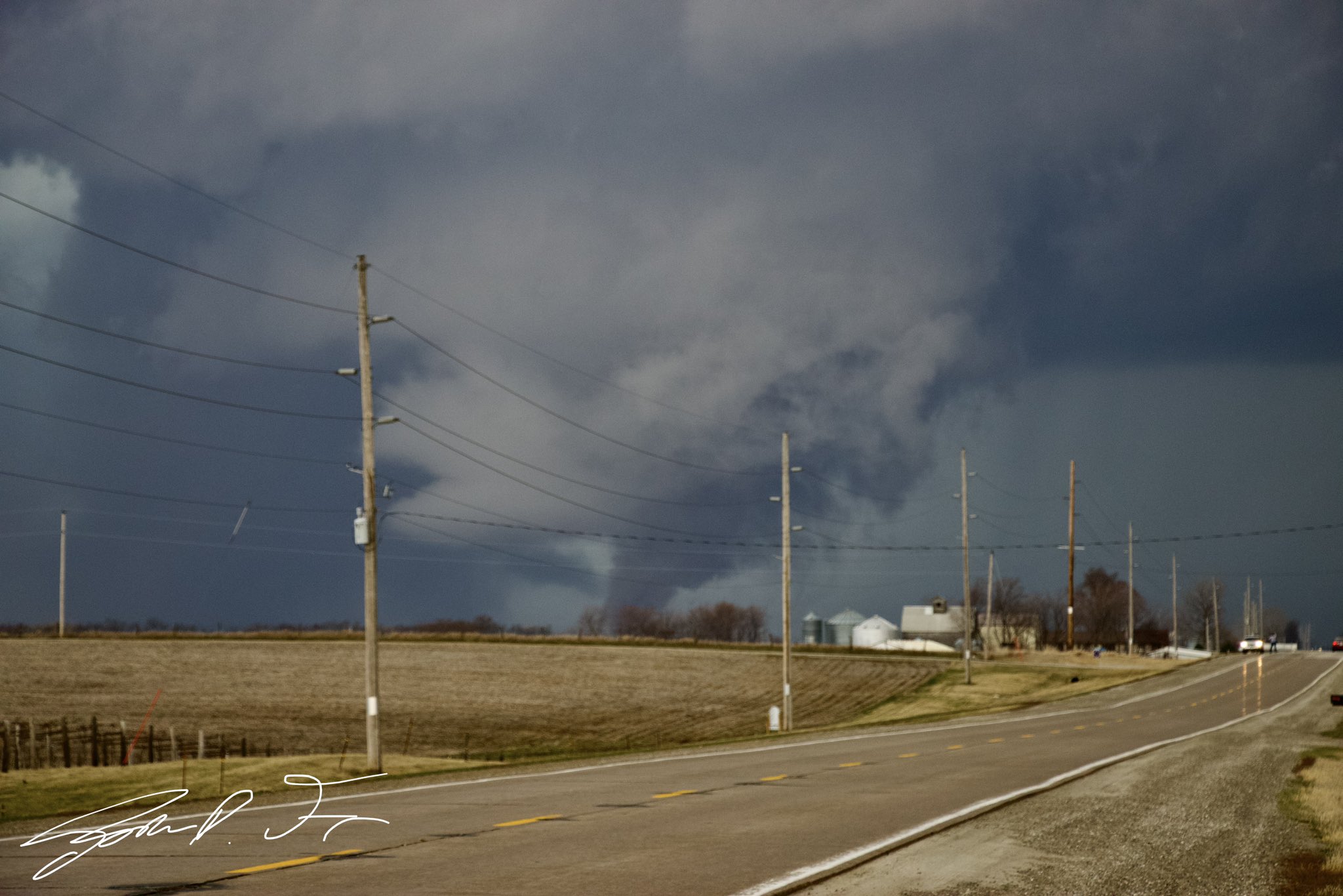
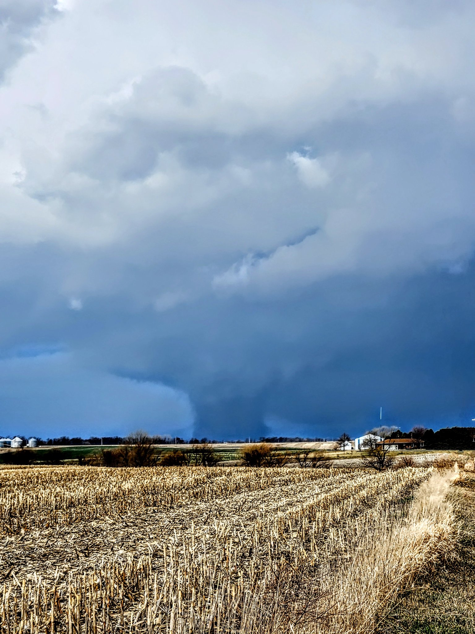
| Keota, IA (Josh Franson) |
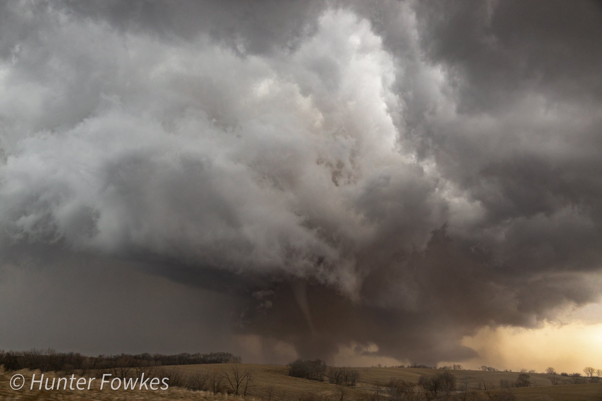
Keota, IA (Hunter Fowkes) |
Keota, IA (Sam Ritter) |
 |
 |
 |
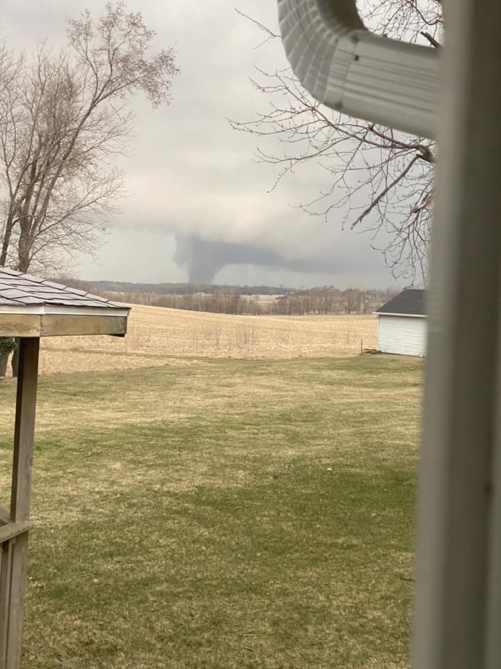
| De Witt Looking Northwest (Clinton EMA) |
West Branch, IA (Nick Stewart) |
2 W Packwood, IA (David Foster) |
 |
||
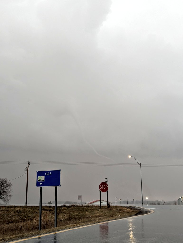
| Keota, IA (Andre Wehrle) |
Radar
| Local Radar Loop | EF-4 Parent Supercell Thunderstorm Radar Loop |
 |
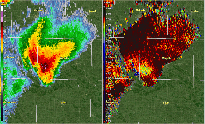 |
| Interactive Radar Loop - Courtesy IEM | This two hour long radar loop of the KDVN 0.5° reflectivity (left) and correlation coefficient (right) covers 3:20 PM - 5:20 PM and is centered on the supercell thunderstorm that produced the EF3 and EF4 tornadoes in southeast Iowa. Much of the blue in the correlation coefficient indicate the presence of non-meteorological targets, or in this case, debris lofted by the strong tornadoes. The height in which the debris had been lofted correlates to violent tornado intensity. |
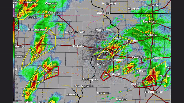
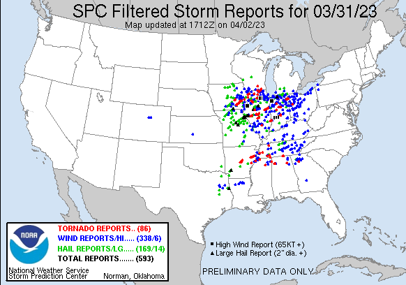
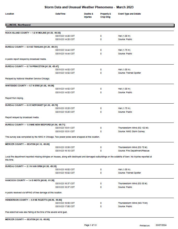
Storm Reports
| SPC Storm Reports | March 31 Storm Reports | |
 |
 |
|
| Interactive Storm Report Map (SPC) | ||
| Interactive Storm Report Map (IEM) |
PRELIMINARY LOCAL STORM REPORT...SUMMARY
NATIONAL WEATHER SERVICE QUAD CITIES IA IL
113 AM CDT SAT APR 1 2023
..TIME... ...EVENT... ...CITY LOCATION... ...LAT.LON...
..DATE... ....MAG.... ..COUNTY LOCATION..ST.. ...SOURCE....
..REMARKS..
0143 PM TSTM WND DMG ANTIOCH 40.31N 91.69W
03/31/2023 CLARK MO LAW ENFORCEMENT
TREE DOWN OVER HIGHWAY 81. PUBLIC REPORT
RELAYED BY LAW ENFORCEMENT.
0148 PM HAIL 2 NNE SPERRY 40.97N 91.14W
03/31/2023 M0.70 INCH DES MOINES IA TRAINED SPOTTER
PEA TO DIME SIZE HAIL.
0208 PM HAIL 1 WSW NEW LONDON 40.92N 91.43W
03/31/2023 M1.00 INCH HENRY IA TRAINED SPOTTER
0320 PM HAIL 2 NE ROCK ISLAND 41.50N 90.55W
03/31/2023 E1.00 INCH ROCK ISLAND IL PUBLIC
0344 PM HAIL TISKILWA 41.29N 89.51W
03/31/2023 M1.75 INCH BUREAU IL PUBLIC
RELAYED BY BROADCAST MEDIA.
0352 PM HAIL ERIE 41.66N 90.08W
03/31/2023 U1.00 INCH WHITESIDE IL PUBLIC
REPORT FROM MPING: QUARTER (1.00 IN.).
0352 PM HAIL PRINCETON 41.38N 89.47W
03/31/2023 M1.00 INCH BUREAU IL TRAINED SPOTTER
RELAYED BY NWS CHICAGO.
0357 PM TORNADO 2 SSE LANCASTER 41.26N 92.15W
03/31/2023 EF0 KEOKUK IA TRAINED SPOTTER
LARGE TORNADO ON THE GROUND.
0410 PM TORNADO 4 W TALLEYRAND 41.30N 92.04W
03/31/2023 KEOKUK IA PUBLIC
0421 PM TORNADO WELLMAN 41.47N 91.84W
03/31/2023 WASHINGTON IA PUBLIC
MICHAEL HARTLEY HEADING TOWARDS KALONA
SPOTTER REPORT.
0425 PM HAIL NEPONSET 41.30N 89.79W
03/31/2023 E1.75 INCH BUREAU IL PUBLIC
CYLE DICKENS NWS CHAT.
0427 PM HAIL COGGON 42.28N 91.53W
03/31/2023 E0.70 INCH LINN IA EMERGENCY MNGR
NWSCHAT.
0429 PM HAIL KEOTA 41.36N 91.96W
03/31/2023 M1.00 INCH KEOKUK IA TRAINED SPOTTER
0430 PM TSTM WND GST GARRISON 42.15N 92.14W
03/31/2023 M60 MPH BENTON IA EMERGENCY MNGR
0430 PM HAIL GARRISON 42.14N 92.14W
03/31/2023 E1.00 INCH BENTON IA EMERGENCY MNGR
0433 PM TORNADO 2 NE WELLMAN 41.49N 91.80W
03/31/2023 WASHINGTON IA TRAINED SPOTTER
CONFIRMED TORNADO ON THE GROUND BEING
FOLLOWED BY SPOTTERS.
0436 PM TORNADO WELLMAN 41.47N 91.84W
03/31/2023 EF1 WASHINGTON IA LAW ENFORCEMENT
DEPUTY WATCHING, REPORTED IN CHAT ROOM.
0440 PM HAIL VAN HORNE 42.01N 92.09W
03/31/2023 M1.00 INCH BENTON IA TRAINED SPOTTER
0440 PM HAIL JESUP 42.48N 92.07W
03/31/2023 E0.50 INCH BUCHANAN IA TRAINED SPOTTER
PEA TO HALF INCH SIZED HAIL.
0441 PM HAIL 1 W VAN HORNE 42.01N 92.11W
03/31/2023 E0.50 INCH BENTON IA TRAINED SPOTTER
OCCURRING RIGHT NOW. PEA TO HALF INCH HAIL
AND A LOT OF IT.
0444 PM TSTM WND DMG 2 NE GARRISON 42.16N 92.11W
03/31/2023 BENTON IA FIRE DEPT/RESCUE
FIRE DEPARTMENT REPORTED 70 MPH WITH DAMAGE
TO HOMES. REPORT RELAYED BY THE EMERGENCY
MANAGER.
0445 PM TSTM WND DMG GARRISON 42.14N 92.14W
03/31/2023 BENTON IA EMERGENCY MNGR
ESTIMATED NEAR 70 MPH WINDS. LARGE BARN WAS
DAMAGED, TRAILER DAMAGED, TREE BRANCHES
DOWN, AND AN OUTBUILDING WITH DAMAGE.
POSSIBLE TORNADO.
0445 PM TSTM WND DMG 1 NW VINTON 42.17N 92.03W
03/31/2023 BENTON IA PUBLIC
BARNS DOWN NEAR VINTON AFTER INITIAL LINE
WENT THROUGH, POSSIBLE TORNADO.
0446 PM HAIL 2 NE GARRISON 42.16N 92.11W
03/31/2023 E1.00 INCH BENTON IA EMERGENCY MNGR
0446 PM HAIL 2 SSW WILLIAMSTOWN 41.54N 91.74W
03/31/2023 E0.50 INCH JOHNSON IA TRAINED SPOTTER
0450 PM HAIL 2 WSW BECKWITH 41.01N 91.91W
03/31/2023 E0.25 INCH JEFFERSON IA PUBLIC
HIGH WINDS BREAKING BRANCHES.
0455 PM HAIL 1 WSW CEDAR RAPIDS 41.97N 91.69W
03/31/2023 E0.25 INCH LINN IA TRAINED SPOTTER
DEBRIS FALLING, WOOD AND HUSKS.
0459 PM HAIL CORALVILLE 41.69N 91.60W
03/31/2023 E1.00 INCH JOHNSON IA PUBLIC
HAIL INCREASING AND SHEET METAL AND
INSULATION FALLING FROM THE SKY.
0500 PM HAIL VAN HORNE 42.01N 92.09W
03/31/2023 M1.00 INCH BENTON IA TRAINED SPOTTER
0502 PM HAIL 2 N VAN ORIN 41.58N 89.35W
03/31/2023 M1.00 INCH BUREAU IL TRAINED SPOTTER
0505 PM TSTM WND GST 1 WNW BELLE PLAINE 41.91N 92.30W
03/31/2023 M70 MPH BENTON IA EMERGENCY MNGR
AT LEAST 70; COULD BE 70 PLUS WIND GUST.
0515 PM HAIL 2 E NORTH LIBERTY 41.74N 91.58W
03/31/2023 M1.75 INCH JOHNSON IA PUBLIC
0520 PM TSTM WND DMG LISBON 41.92N 91.39W
03/31/2023 LINN IA TRAINED SPOTTER
TREES DOWN AT THIS LOCATION. 6 INCH DIAMETER
TREES.
0520 PM TSTM WND DMG 1 NW KAHOKA 40.43N 91.72W
03/31/2023 CLARK MO TRAINED SPOTTER
LIGHT DAMAGE TO BUILDINGS, SIGNS BLOWN DOWN,
AND 3-8 INCH TREE LIMBS DOWN. ESTIMATE NEAR
70-80 MPH WINDS.
0525 PM HAIL FORT MADISON 40.41N 91.40W
03/31/2023 E0.70 INCH LEE IA TRAINED SPOTTER
STRONG WIND TRAFFIC STUCK ON THE BYPASS.
0528 PM TSTM WND DMG 1 SSW MANCHESTER 42.47N 91.47W
03/31/2023 DELAWARE IA EMERGENCY MNGR
BUILDINGS DOWN ON BURRINGTON RD AND SOUTH
5TH. ALSO POWER POLES DOWN.
0528 PM HAIL COLUMBUS JUNCTION 41.28N 91.36W
03/31/2023 E1.00 INCH LOUISA IA TRAINED SPOTTER
SC556 STORM CHASER.
0529 PM HAIL VINTON 42.17N 92.03W
03/31/2023 M1.00 INCH BENTON IA TRAINED SPOTTER
0532 PM TSTM WND GST NORWAY 41.90N 91.92W
03/31/2023 E70 MPH BENTON IA TRAINED SPOTTER
DELAYED REPORT.
0534 PM TSTM WND GST YARMOUTH 41.03N 91.32W
03/31/2023 M61 MPH DES MOINES IA FIRE DEPT/RESCUE
0535 PM TSTM WND GST MUSCATINE MUNICIPALITY 41.37N 91.15W
03/31/2023 M63 MPH MUSCATINE IA AWOS
AWOS.
0536 PM TSTM WND GST CEDAR RAPIDS MUNICIPALI 41.88N 91.72W
03/31/2023 M69 MPH LINN IA ASOS
ASOS.
0537 PM TSTM WND DMG 1 SSE NIOTA 40.60N 91.28W
03/31/2023 HANCOCK IL PUBLIC
MPING OF TREE DAMAGE AT LOCATION.
0537 PM TSTM WND GST WEVER 40.72N 91.23W
03/31/2023 E55 MPH LEE IA TRAINED SPOTTER
0537 PM TSTM WND GST SHELLSBURG 42.09N 91.87W
03/31/2023 M70 MPH BENTON IA EMERGENCY MNGR
0538 PM TSTM WND DMG 1 SE BEAVERDALE 40.84N 91.21W
03/31/2023 DES MOINES IA TRAINED SPOTTER
SEMI BLOWN OFF THE ROAD ON HIGHWAY 61.
0539 PM TSTM WND DMG 1 ESE CORALVILLE 41.68N 91.58W
03/31/2023 JOHNSON IA TRAINED SPOTTER
BUILDINGS DOWN IN CORALVILLE FROM THE STRIP
TO BOSTON WAY, NEAR THE MALL.
0541 PM TSTM WND DMG MEDIAPOLIS 41.01N 91.17W
03/31/2023 DES MOINES IA EMERGENCY MNGR
5 HOUSES MISSING ROOFS; TRAMPOLINE IN A TREE
WITH CONSIDERABLE OTHER DAMAGE. TIME
ESTIMATED FROM RADAR.
0542 PM TSTM WND GST BURLINGTON REGIONAL AIR 40.78N 91.13W
03/31/2023 M59 MPH DES MOINES IA ASOS
ASOS.
0542 PM HAIL LOWDEN 41.86N 90.92W
03/31/2023 E0.75 INCH CEDAR IA CO-OP OBSERVER
GUSTY WINDS ROTATION SPOTTED.
0545 PM HAIL LOWDEN 41.86N 90.92W
03/31/2023 M1.50 INCH CEDAR IA CO-OP OBSERVER
0545 PM HAIL 2 N BURLINGTON 40.84N 91.12W
03/31/2023 M0.70 INCH DES MOINES IA TRAINED SPOTTER
VIA SOCIAL MEDIA. TIME ESTIMATED.
0545 PM TSTM WND GST HIAWATHA 42.05N 91.68W
03/31/2023 E70 MPH LINN IA TRAINED SPOTTER
ALSO PEA SIZED HAIL.
0552 PM TSTM WND GST 1 N ROZETTA 40.96N 90.86W
03/31/2023 M81 MPH HENDERSON IL PUBLIC
ALSO PEA SIZED HAIL.
0554 PM TSTM WND DMG MEDIAPOLIS 41.01N 91.17W
03/31/2023 DES MOINES IA TRAINED SPOTTER
REPORTS OF DAMAGE TO HOMES.
0556 PM HAIL DAVENPORT MUNICIPALITY 41.61N 90.58W
03/31/2023 M0.25 INCH SCOTT IA OFFICIAL NWS OBS
AT THE OFFICE.
0600 PM TSTM WND DMG SEATON 41.10N 90.80W
03/31/2023 MERCER IL FIRE DEPT/RESCUE
CORRECTS PREVIOUS TSTM WND DMG REPORT FROM
SEATON. DAMAGE SEEMED MORE SEVERE THAN
STRAIGHT LINE WINDS, MISSING SHINGLES,
DESTROYED AND DAMAGED OUTBUILDINGS ON THE
OUT SKIRTS OF TOWN. NO INJURIES REPORTED AT
THIS TIME.
0600 PM HAIL 1 NNW MAQUOKETA 42.07N 90.67W
03/31/2023 E0.88 INCH JACKSON IA TRAINED SPOTTER
DIME TO NICKEL HAIL. TIME ESTIMATED.
0600 PM TSTM WND DMG 4 SW ELEANOR 40.94N 90.75W
03/31/2023 WARREN IL TRAINED SPOTTER
CORRECTS THE TIME OF THE TSTM WND DMG REPORT
FROM 4 SW ELEANOR. TOPS SNAPPED OUT OF
TREES. ESTIMATED WINDS OF 70 TO 75 MPH.
0600 PM HAIL 4 NE ILLINOIS CITY 41.44N 90.84W
03/31/2023 E0.88 INCH ROCK ISLAND IL TRAINED SPOTTER
DIME TO NICKEL HAIL.
0601 PM TSTM WND GST 1 ENE BURLINGTON REGION 40.79N 91.11W
03/31/2023 E65 MPH DES MOINES IA TRAINED SPOTTER
ESTIMATED WINDS OF 60 TO 70 MPH.
0605 PM TSTM WND GST 2 WSW ROCK ISLAND 41.46N 90.61W
03/31/2023 M58 MPH ROCK ISLAND IL TRAINED SPOTTER
I280 AT JUMERS.
0610 PM TSTM WND DMG 1 ESE CORALVILLE 41.68N 91.58W
03/31/2023 JOHNSON IA TRAINED SPOTTER
POSS TORNADO MULTIPLE BUILDINGS DOWN,
COMMERCIAL BUILDINGS SOME APTS MISSING
ROOFS.
0611 PM TSTM WND DMG 2 S EDMORE 42.53N 90.68W
03/31/2023 DUBUQUE IA TRAINED SPOTTER
POWER LINES AND TREES DOWN AT INTERSECTION
OF 32ND ST AND PERU ROAD.
0613 PM HAIL 1 NNW FRUITLAND 41.49N 90.52W
03/31/2023 U1.00 INCH ROCK ISLAND IL PUBLIC
REPORT FROM MPING: QUARTER (1.00 IN.).
0613 PM TSTM WND DMG 2 SSW MILLERSBURG 41.21N 90.83W
03/31/2023 MERCER IL TRAINED SPOTTER
LIMBS DOWN ESTIMATED WINDS OF 70 MPH.
0613 PM HAIL BETTENDORF 41.56N 90.48W
03/31/2023 E1.00 INCH SCOTT IA PUBLIC
4015 WAKONDA DRIVE.
0614 PM TSTM WND GST MOLINE QUAD-CITY AIRPOR 41.45N 90.50W
03/31/2023 M53 MPH ROCK ISLAND IL ASOS
ASOS.
0615 PM HAIL 2 W BETTENDORF 41.56N 90.51W
03/31/2023 E1.00 INCH SCOTT IA TRAINED SPOTTER
0618 PM TSTM WND GST LORE 42.52N 90.80W
03/31/2023 M73 MPH DUBUQUE IA TRAINED SPOTTER
WIND DATA CAPTURED FROM OBSERVATION
EQUIPMENT. DOWNED TREE AT LOCATION WAS 6IN
DIAMETER. OTHER LARGE BRANCHES DOWN.
0620 PM HAIL HAMPTON 41.55N 90.41W
03/31/2023 M0.75 INCH ROCK ISLAND IL PUBLIC
VIA SOCIAL MEDIA.
0620 PM TSTM WND DMG WOODHULL 41.18N 90.32W
03/31/2023 HENRY IL TRAINED SPOTTER
ROOF OFF OF A BARN WITH DAMAGE TO
OUTBUILDINGS.
0623 PM HAIL 2 E SPRING LAKE 41.51N 90.68W
03/31/2023 E0.75 INCH SCOTT IA TRAINED SPOTTER
0627 PM TSTM WND DMG 2 ESE NEKOMA 41.17N 90.15W
03/31/2023 HENRY IL EMERGENCY MNGR
4 POWER POLES BROKEN. TIME ESTIMATED FROM
RADAR.
0627 PM TSTM WND GST 1 ESE CAMANCHE 41.79N 90.26W
03/31/2023 E50 MPH CLINTON IA TRAINED SPOTTER
50+ MPH WINDS AND RAIN COMING IN ALL
DIRECTIONS SHAKING THE CAR NEAR FOLLETTS,
IA.
0630 PM TSTM WND DMG 1 E DUBUQUE 42.51N 90.67W
03/31/2023 DUBUQUE IA TRAINED SPOTTER
LARGE TREE BLOWN DOWN.
0630 PM TSTM WND GST DUBUQUE REGIONAL ARPT 42.40N 90.72W
03/31/2023 M68 MPH DUBUQUE IA ASOS
ASOS.
0630 PM TORNADO 2 W GENESEO 41.45N 90.19W
03/31/2023 EF0 HENRY IL LAW ENFORCEMENT
STATE POLICE SIGHTED MOVING EAST.
0634 PM TSTM WND DMG CAMBRIDGE 41.31N 90.19W
03/31/2023 HENRY IL TRAINED SPOTTER
POSSIBLE TORNADO, NEAR CEMETERY. WINDS
GUSTING UP TO 50 MPH. DIME SIZE HAIL.
0636 PM TSTM WND DMG 3 NNE ATKINSON 41.46N 90.00W
03/31/2023 HENRY IL TRAINED SPOTTER
TORNADO POSSIBLE, DETACHED GARAGE DAMAGED.
SEVERAL TREE LIMBS DOWN, ONE WINDOW BROKEN
IN THE HOMES. DAMAGE TO FARM OUTBUILDINGS.
TIME OF THE EVENT ESTIMATED USING RADAR.
0636 PM TSTM WND DMG 4 S GERMAN CORNER 41.24N 90.04W
03/31/2023 HENRY IL PUBLIC
2 GRAIN BINS BLOWN DOWN. TIME ESTIMATED FROM
RADAR.
0640 PM NON-TSTM WND DMG 2 N DUBUQUE REGIONAL AR 42.42N 90.71W
03/31/2023 DUBUQUE IA TRAINED SPOTTER
POWER POLE SNAPPED AT ROOSEVELT AND PERU.
0642 PM TSTM WND DMG 3 SSE MOUNT CARROLL 42.05N 89.95W
03/31/2023 CARROLL IL FIRE DEPT/RESCUE
POWER POLES DOWN. POSSIBLE TORNADO DAMAGE.
0646 PM HEAVY RAIN 1 W BETTENDORF 41.56N 90.49W
03/31/2023 M2.00 INCH SCOTT IA TRAINED SPOTTER
FELL SINCE ABOUT 1PM.
0648 PM TSTM WND DMG 2 SE DAVENPORT 41.54N 90.57W
03/31/2023 SCOTT IA TRAINED SPOTTER
80MPH WINDS 13TH AND MAIN IN DAVENPORT
BRANCHES DOWN, POWER POLE BENT AT 30 DEGREE
ANGLE, STORM WINDOW KNOCKED IN TO BEDROOM.
0650 PM TORNADO 2 N KEWANEE 41.27N 89.93W
03/31/2023 HENRY IL PUBLIC
MET STUDENTS FROM NIU SAW THE TORNADO CROSS
ILLINOIS 78 NORTH OF TOWN FOLLOWED BY
TRANSFORMER EXPLOSIONS.
0652 PM TSTM WND DMG 4 S SHANNON 42.10N 89.74W
03/31/2023 CARROLL IL FIRE DEPT/RESCUE
DAMAGE TO HOMES FROM POSSIBLE TORNADO.
0653 PM TSTM WND DMG 4 NNW NEW BEDFORD 41.57N 89.75W
03/31/2023 BUREAU IL EMERGENCY MNGR
MULTIPLE OUTBUILDINGS AND A DETACHED GARAGE
DOWN WITH SIDING DAMAGE TO A HOUSE. TIME
ESTIMATED FROM RADAR.
0654 PM TSTM WND DMG 1 NW MANLIUS 41.47N 89.68W
03/31/2023 BUREAU IL EMERGENCY MNGR
TWO BUILDINGS DAMAGED; 40X50 SHED DOWN AND
AN 80X100 SHED WITH THE ROOF REMOVED. TIME
ESTIMATED FROM RADAR.
0705 PM TSTM WND GST 3 N STOCKTON 42.40N 90.00W
03/31/2023 M51 MPH JO DAVIESS IL CO-OP OBSERVER
0707 PM TSTM WND GST 4 NNE STOCKTON 42.40N 89.99W
03/31/2023 M64 MPH JO DAVIESS IL TRAINED SPOTTER
0714 PM TSTM WND DMG 3 NNE CEDAR RAPIDS 42.01N 91.66W
03/31/2023 LINN IA TRAINED SPOTTER
1INCH DIAMETER STEEL FLAG POLE, BENT 30
DEGREE ANGLE AT THE BASE TREE DEBRIS BLOWN
FORM A DISTANCE ONTO THE PROPERTY.
0719 PM TSTM WND DMG 2 N DUBUQUE REGIONAL AR 42.42N 90.71W
03/31/2023 DUBUQUE IA TRAINED SPOTTER
ASBURY AND JFK LARGE TREE BRANCH BLOCKING AN
ENTIRE LANE.
0722 PM TSTM WND DMG 3 SSW HOMESTEAD 41.73N 91.89W
03/31/2023 IOWA IA TRAINED SPOTTER
LOST PART OF METAL BARN ROOF CATTLE SHED
DESTROYED.
0724 PM TSTM WND DMG 2 N DUBUQUE REGIONAL AR 42.42N 90.71W
03/31/2023 DUBUQUE IA TRAINED SPOTTER
8INCH DIAMETER BRANCHES DOWN.
Environment
The culprit to this outbreak was a potent low pressure system that developed on the morning of March 31 and tracked across the state of Iowa. This system pulled unseasonably warm and moist conditions into the Midwest, that when coupled with a very favorable wind profile created a volatile environment for severe thunderstorms. Discrete supercell thunderstorms initially occurred, but quickly transitioned into a quasi-linear area of storms resulting in additional tornadoes and severe straight-line winds.
SPC Severe Weather Event Page March 31, 2023
 |
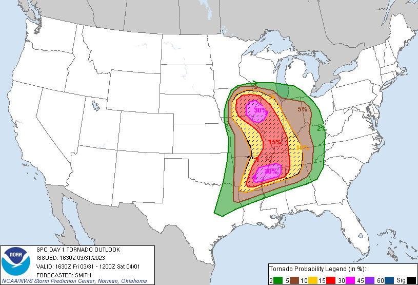 |
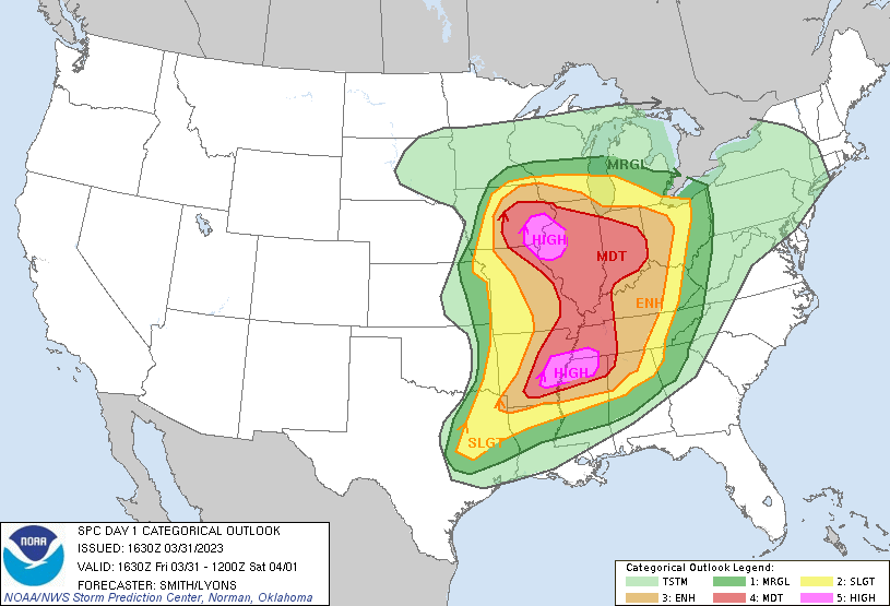
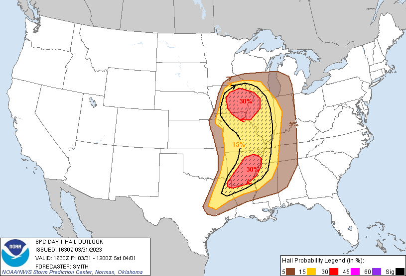 |
| Figure 1: SPC 1630z Day 1 Outlook | Figure 2: SPC 1630z Day 1 Tornado Probabilities | Figure 3: SPC 1630z Day 1 Hail Probabilities |
 |
 |
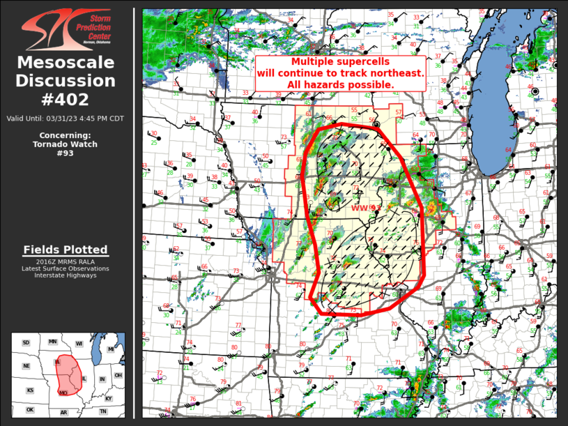 |
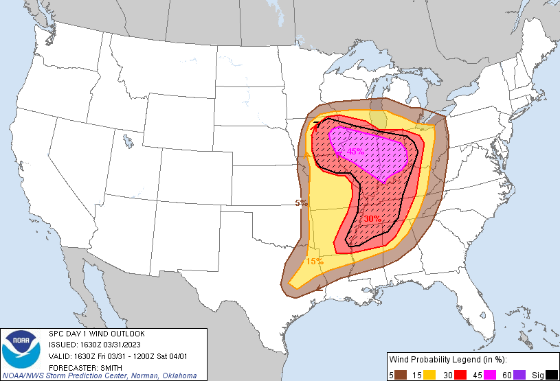
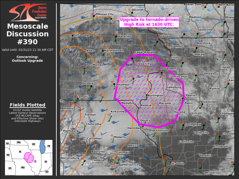
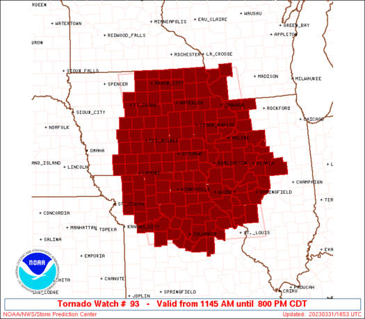
| Figure 2: SPC 1630z Day 1 Wind Probabilities | Figure 5: Mesoscale Discussion | Figure 6: Mesoscale Discussion |
 |
 |
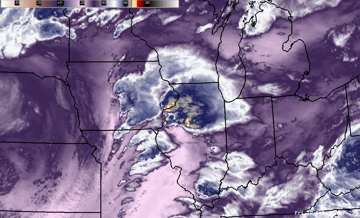 |
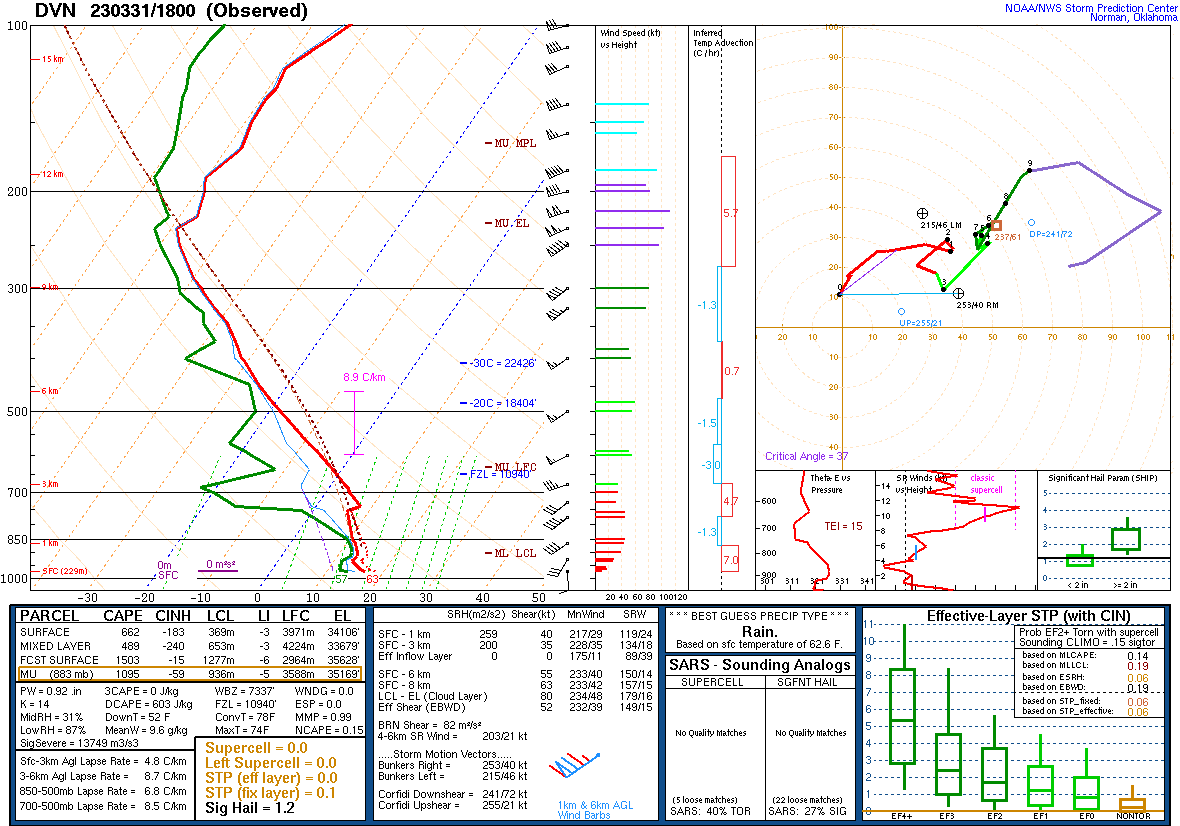
| Figure 7: Tornado Watch Area | Figure 8: 18z (1 PM CDT) DVN Sounding | Figure 9: Loop of GOES-16 "mid-level" water vapor imagery between approximately 3:00 and 9:30 PM CDT (courtesy NWS Chicago) |
 |
 |
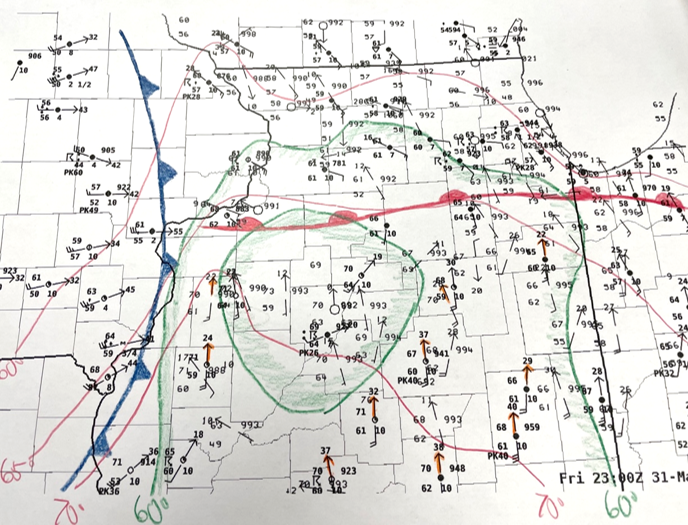 |
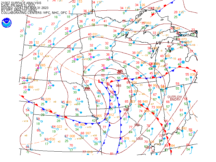
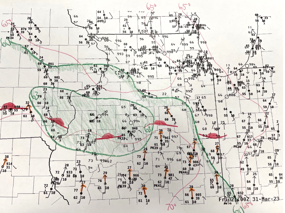
| Figure 10: 21Z (4 PM CDT) Surface Weather Map | Figure 11: 21Z (4 PM CDT) surface hand analysis of strengthening warm front across southeast Iowa and central Illinois, with the parent supercell of the violent tornado beginning near this time near Ottumwa, IA. | Figure 12: 23Z (6 PM CDT) surface hand analysis of "triple point" area (lower relative pressure) tracking east near I-80 as the storms evolved from tornadic supercells to a tornadic and severe wind-producing quasi-linear convective system (QLCS). |
Individual Tornadoes
|
Tornado #1 - Martinsburg, IA
Track Map 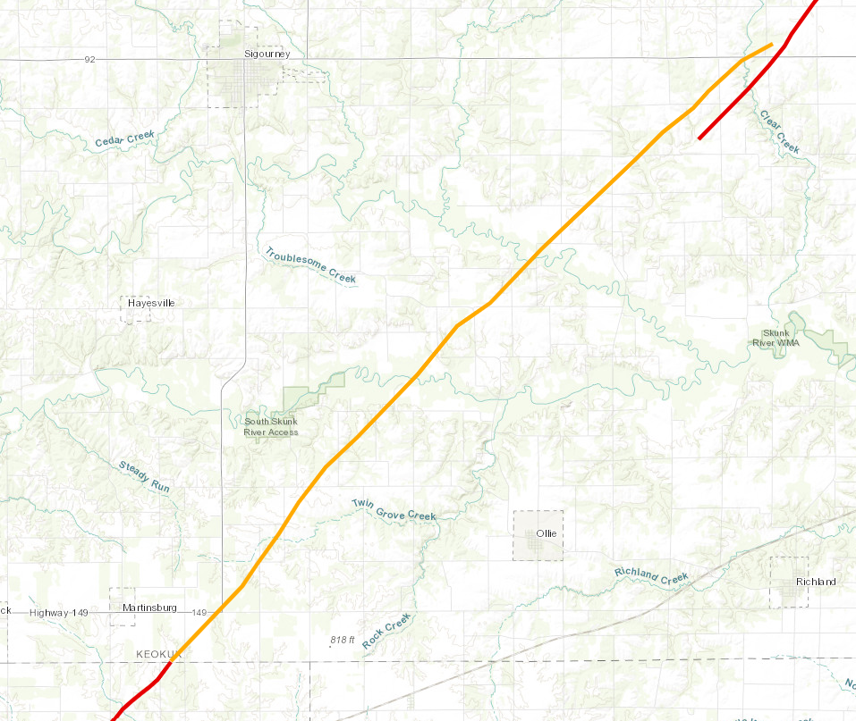 
|
||||||||||||||||
|
Tornado #2 - Keota, IA
Track Map
|
||||||||||||||||
|
Tornado #3 - Vinton, IA
Track Map 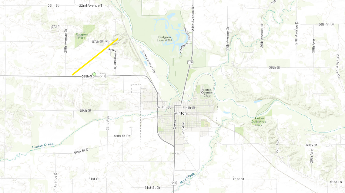 |
||||||||||||||||
|
Tornado #4 - Amish to Frytown, IA
Track Map 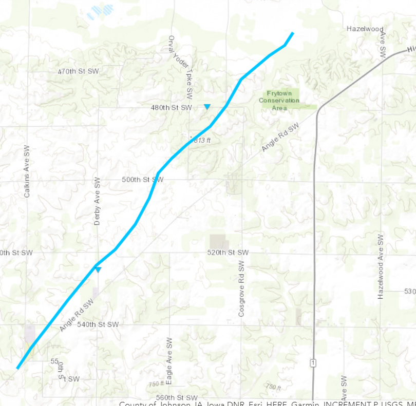 |
||||||||||||||||
|
Tornado #5 - Coralville to Solon, IA
Track Map 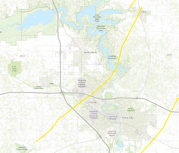
|
||||||||||||||||
|
Tornado #6 - Mount Auburn, IA
Track Map 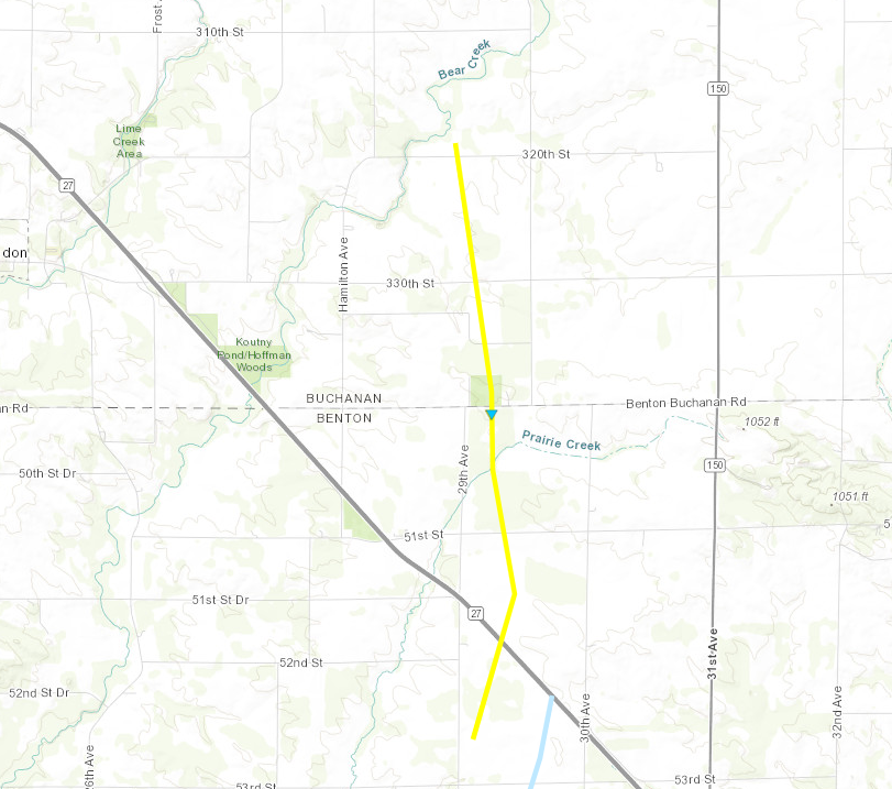 |
||||||||||||||||
|
Tornado #7 - Urbana, IA
Track Map 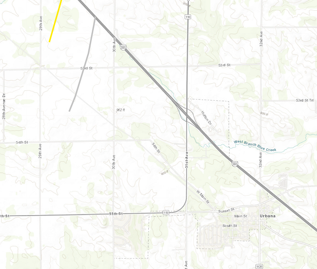 |
||||||||||||||||
|
Tornado #8 - Hills, IA
Track Map 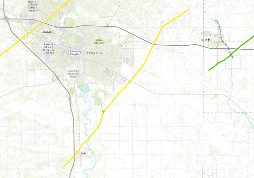
|
||||||||||||||||
|
Tornado #9 - Rowley, IA
Track Map 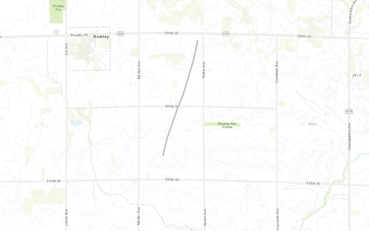 |
||||||||||||||||
|
Tornado #10 - Solon to Mount Vernon, IA
Track Map 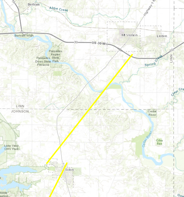 |
||||||||||||||||
|
Tornado #11 - West Branch, IA
Track Map 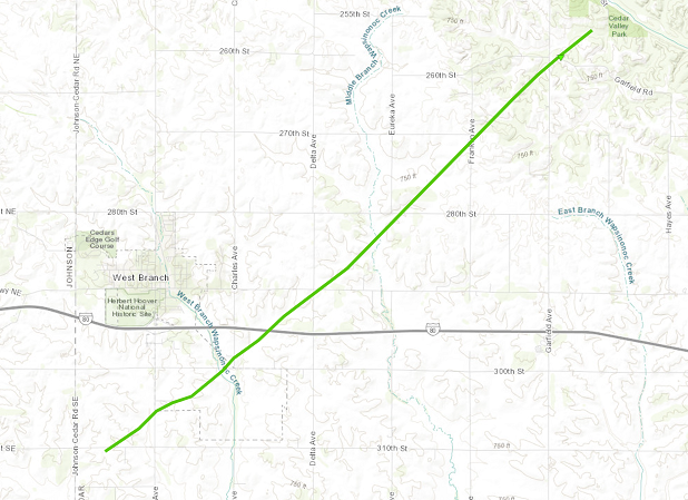 |
||||||||||||||||
|
Tornado #12 - Tipton to Clarence IA
Track Map 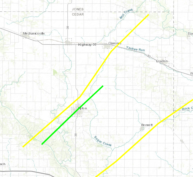 |
||||||||||||||||
|
Tornado #13 - Tipton, IA
Track Map |
||||||||||||||||
|
Tornado #14 - Bennett, IA
Track Map 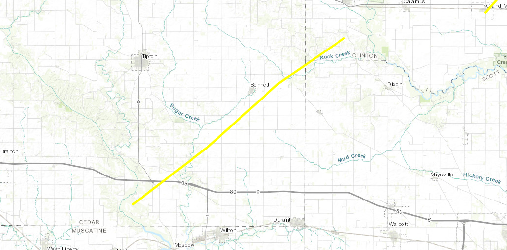
|
||||||||||||||||
|
Tornado #15 - Manchester, IA
Track Map 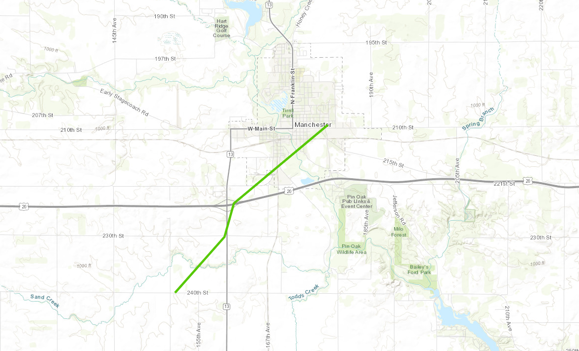 |
||||||||||||||||
|
Tornado #16 - Oneida-Greeley, IA
Track Map 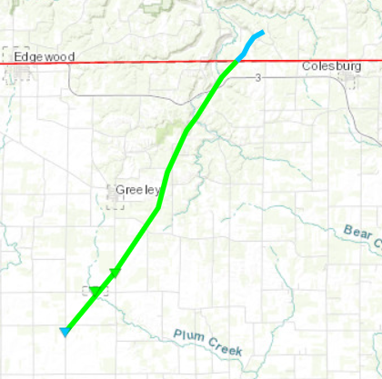 |
||||||||||||||||
|
Tornado #17 - Mediapolis, IA
Track Map 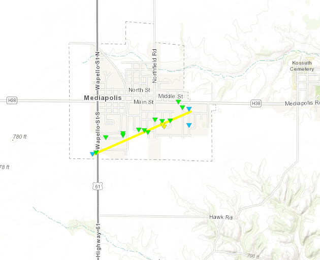 |
||||||||||||||||
|
Tornado #18 - Wyoming, IA
Track Map 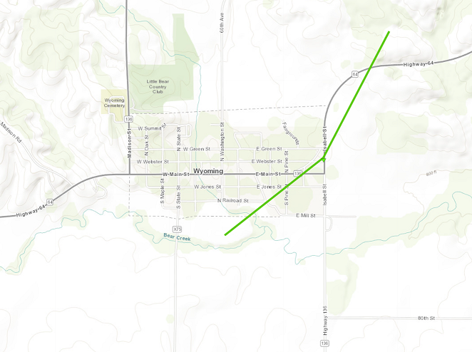 |
||||||||||||||||
|
Tornado #19 - Charlotte, IA
Track Map 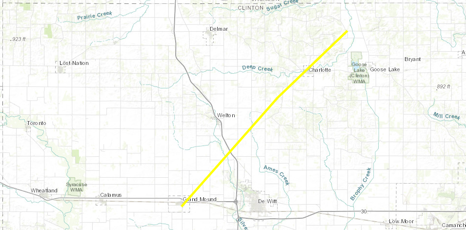
|
||||||||||||||||
|
Tornado #20 - Fulton, IA
Track Map 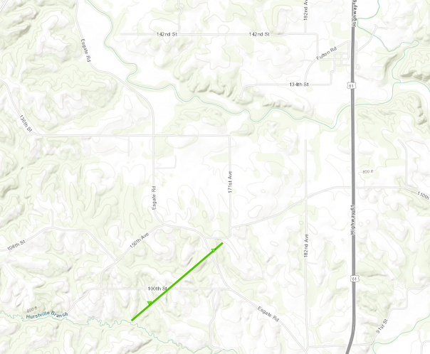 |
||||||||||||||||
|
Tornado #21 - Andrew, IA
Track Map 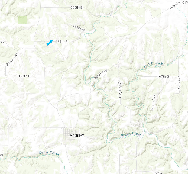 |
||||||||||||||||
|
Tornado #22 - Bellevue, IA
Track Map 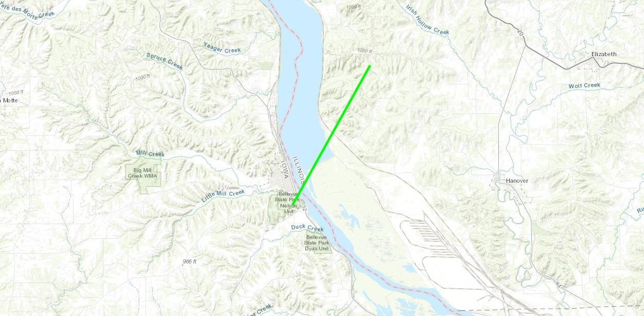
|
||||||||||||||||
|
Tornado #23 - Geneseo, IL
Track Map 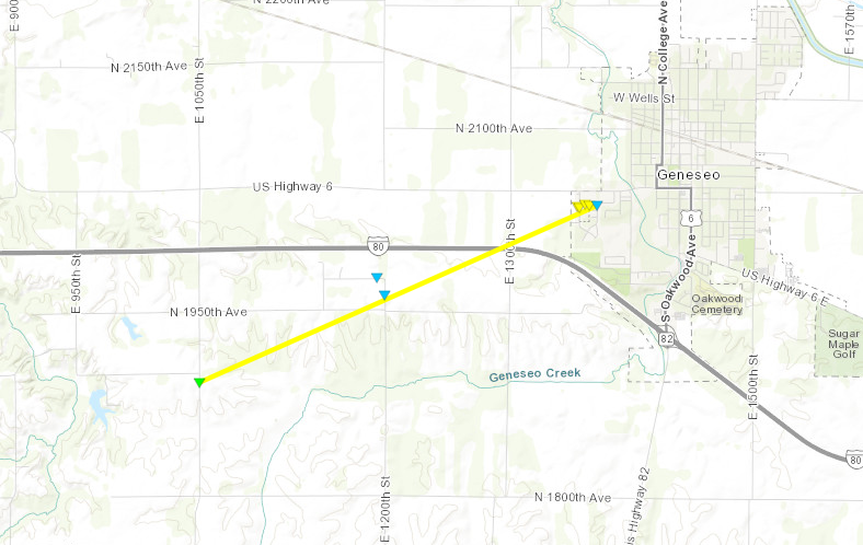
|
||||||||||||||||
|
Tornado #24 - Atkinson, IL
Track Map 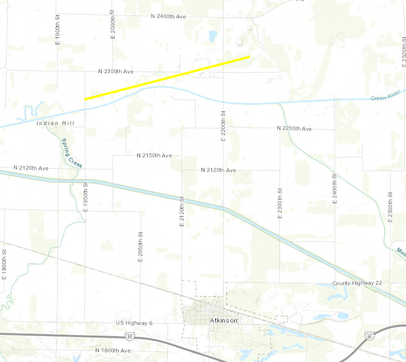 |
||||||||||||||||
|
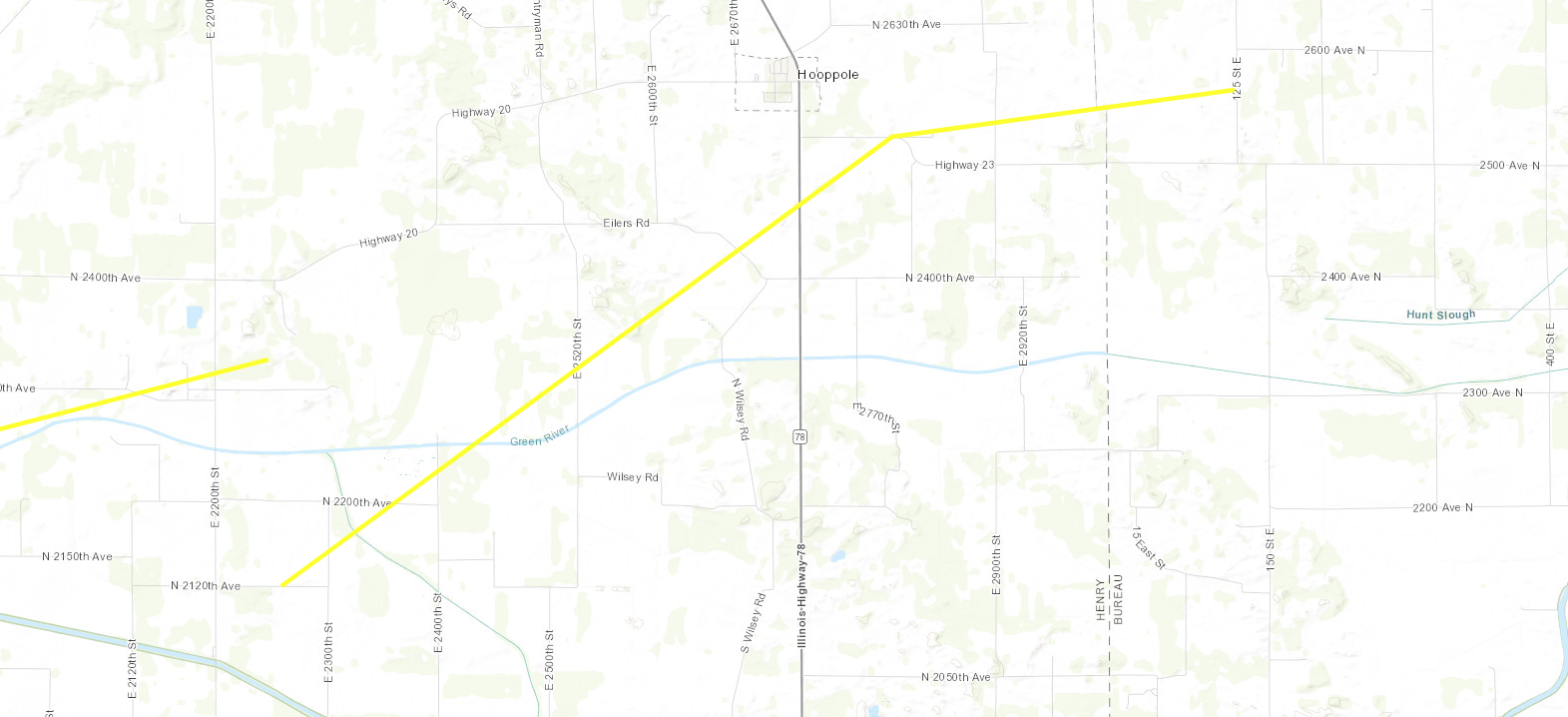
Tornado #25 - Hooppole IL
Track Map
|
||||||||||||||||
|
Tornado #26 - Kewanee, IL
Track Map 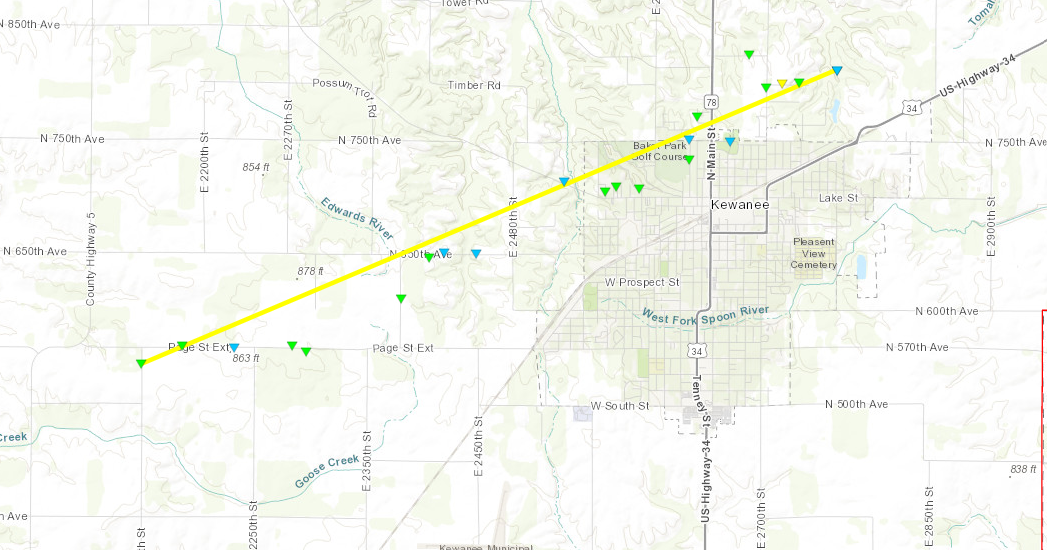 |
||||||||||||||||
|
Tornado #27 - Mount Carroll, IL
Track Map 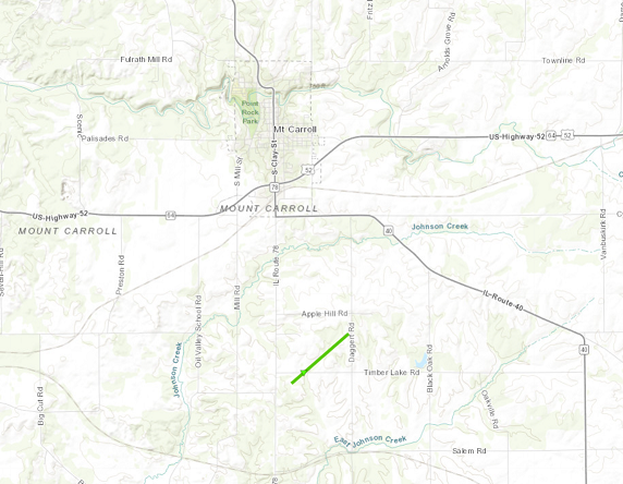 |
||||||||||||||||
|
Tornado #28 - Deer Grove, IL Bureau County, Whiteside County, and Lee County, IL
Track Map 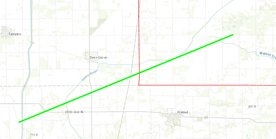
|
||||||||||||||||
|
Tornado #29 - Lanark IL to Baileyville IL Carroll County, Ogle County, and Stephenson County, IL
Track Map 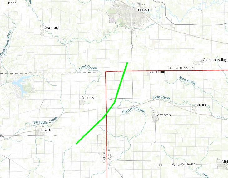
|
||||||||||||||||
The Enhanced Fujita (EF) Scale classifies tornadoes into the following categories:
| EF0 Weak 65-85 mph |
EF1 Moderate 86-110 mph |
EF2 Significant 111-135 mph |
EF3 Severe 136-165 mph |
EF4 Extreme 166-200 mph |
EF5 Catastrophic 200+ mph |
 |
|||||
Research & More
NWS Quad Cities Research & Presentations on March 31, 2023:
The March 31, 2023 Tornado Outbreak - Matthew Friedlein, Timothy Gunkel, & Zachary Uttech as part of a collaborative presentation with NWS Des Moines and NWS Duluth. Central Iowa National Weather Association (NWA) Severe Storms and Doppler Radar Conference Oral Presentation - Ankeny, IA, March 2024.
Science-to-Service Methods During a Violent Tornado in Southeast Iowa During the Historic 31 March - 01 April 2023 Tornado Outbreak - Zachary Uttech & Matthew Friedlein. American Meteorological Society (AMS) Oral Presentation - Baltimore, MD, February 2024.
Early Season Historic Tornado Outbreak Across Iowa and Illinois 31 March 2023 (7-Minute Video Summary) - Zachary Uttech, Matthew Friedlein, & Alex Gibbs. National Weather Association (NWA) Showcase Presentation - Kansas City, MO, September 2023.
Other NWS Office Recaps of March 31-April 1:
Central Iowa (NWS Des Moines)
North Central & Northeast Illinois (NWS Chicago)
Central Illinois | StoryMap (NWS Lincoln)
Southern Wisconsin | StoryMap (NWS Milwaukee)
Central Arkansas (NWS Little Rock)
Eastern Arkansas, Western Tennessee, and Northern Mississippi | StoryMap (NWS Memphis)
Central Tennessee (NWS Nashville)
Northern Indiana (NWS Northern Indiana)
Central Indiana (NWS Indianapolis)
Southeast Michigan (NWS Detroit)
Western and Central Ohio (NWS Wilmington, OH)
Mid-Atlantic (NWS Philadelphia)
 |
Media use of NWS Web News Stories is encouraged! Please acknowledge the NWS as the source of any news information accessed from this site. |
|