
In the Northern Plains into the Upper Great Lakes and Mid-Atlantic, heavy to excessive rain may bring flash and urban flooding Tuesday. Severe thunderstorms producing damaging winds are most likely over parts of the Dakotas into Minnesota Tuesday afternoon into the overnight, with other isolated storms producing hail or wind over the northern High Plains. Extreme heat returns to the southwest U.S. Read More >
Overview
|
|
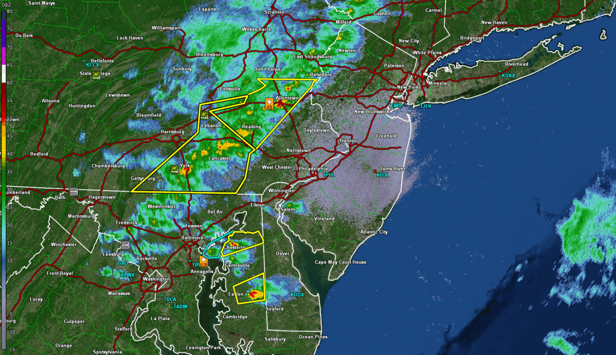 Radar loop from KDIX on April 1st, 2023 |
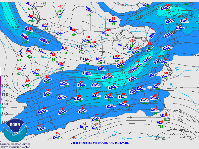
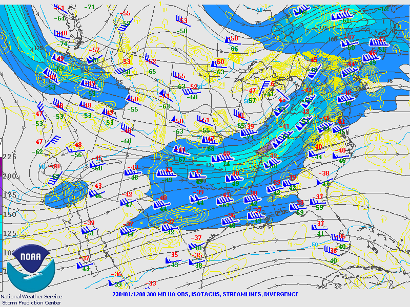
Synoptic Overview at 12z 01 April 2023 (courtesy of SPC)
 |
 |
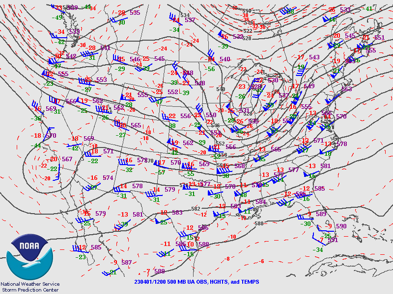 |
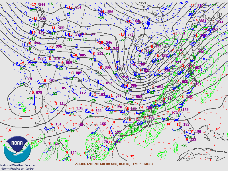
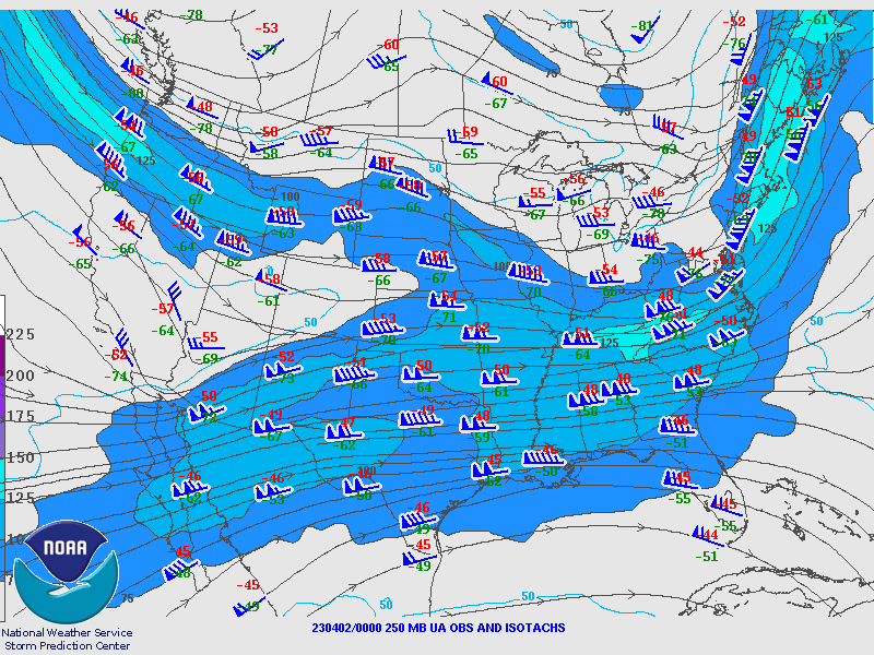
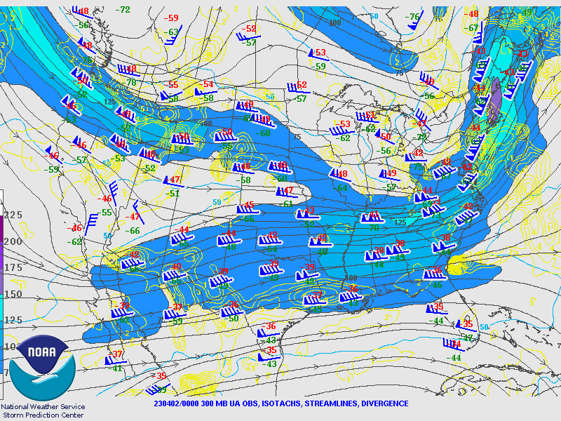
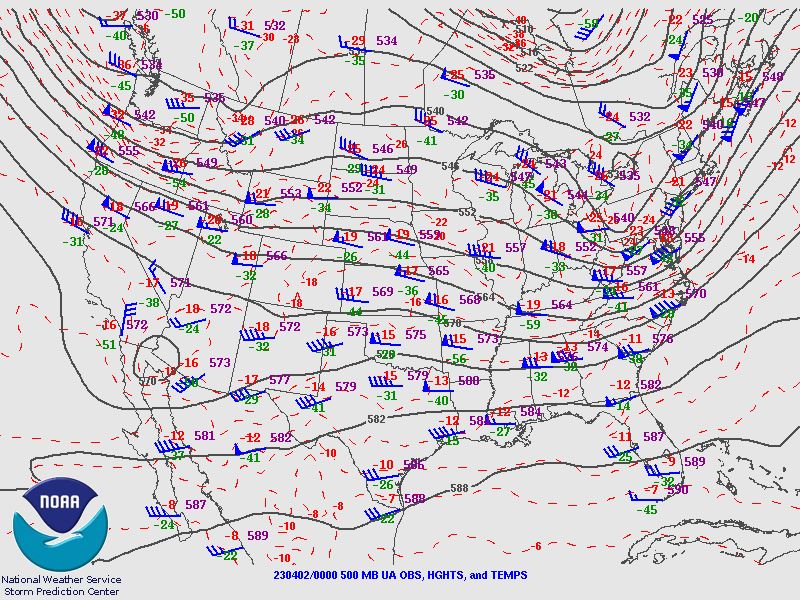
| Figure 1: 250-mb analysis | Figure 2: 300-mb analysis | Figure 3: 500-mb analysis |
 |
 |
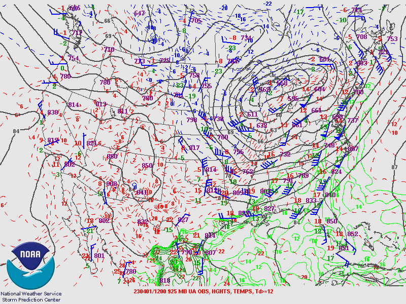 |
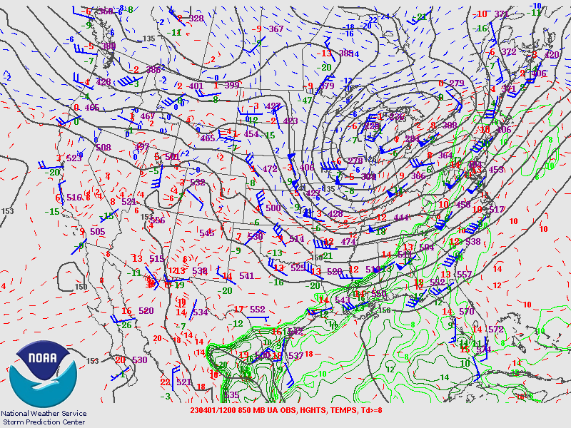
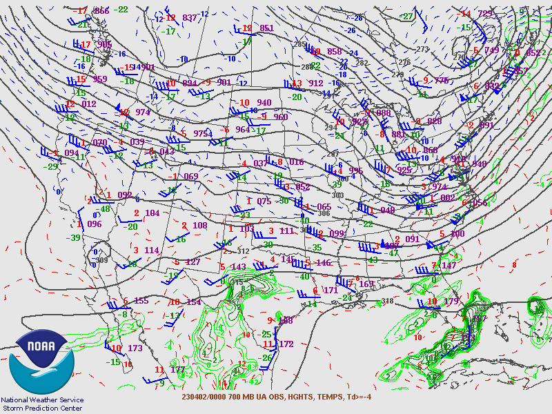
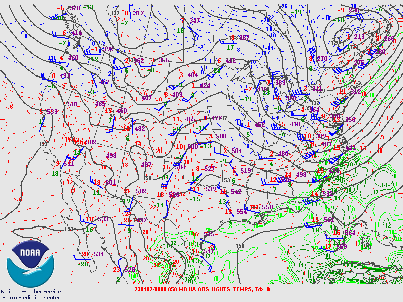
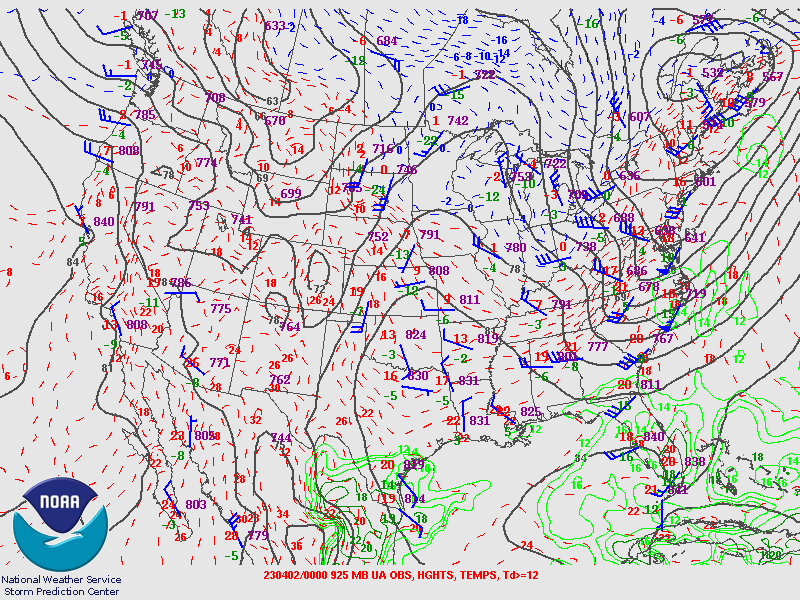
| Figure 4: 700-mb analysis | Figure 5: 850-mb analysis | Figure 6: 925-mb analysis |
Synoptic Overview at 00z 02 April 2023 (courtesy of SPC)
 |
 |
 |
| Figure 7: 250-mb analysis | Figure 8: 300-mb analysis | Figure 9: 500-mb analysis |
 |
 |
 |
| Figure 10: 700-mb analysis | Figure 11: 850-mb analysis | Figure 12: 925-mb analysis |
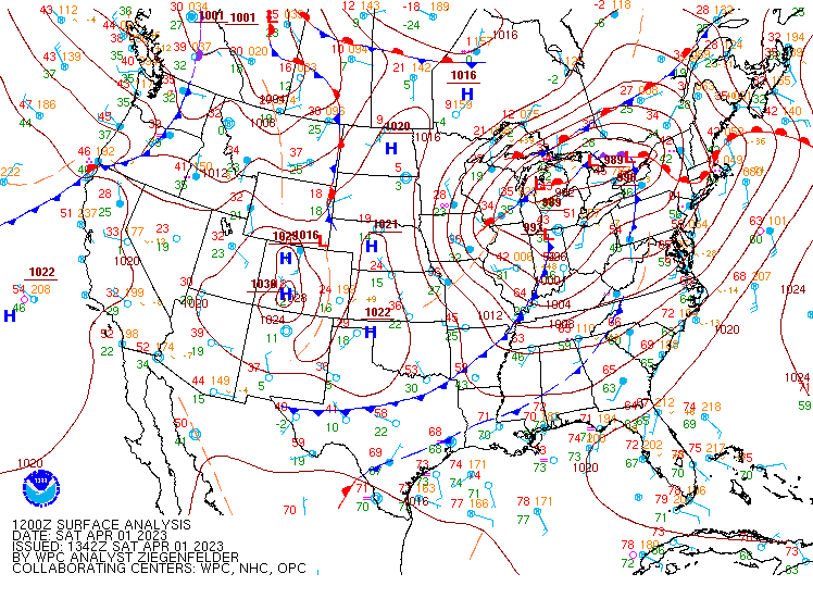
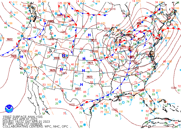
Surface Maps (courtesy of WPC)
 |
 |
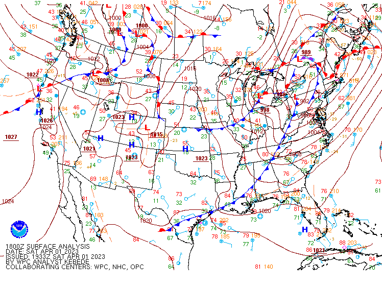 |
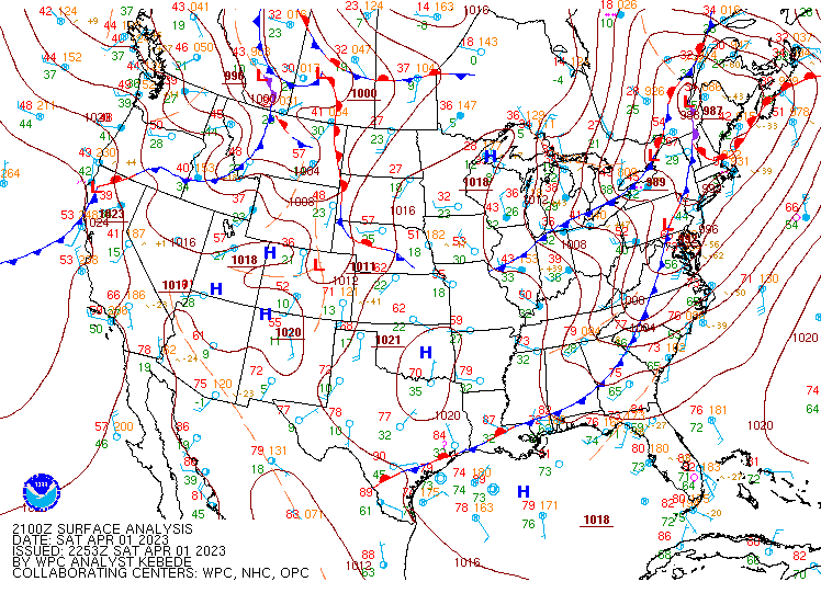
| Figure 13: 12z surface map | Figure 14: 15z surface map | Figure 15: 18z surface map |
 |
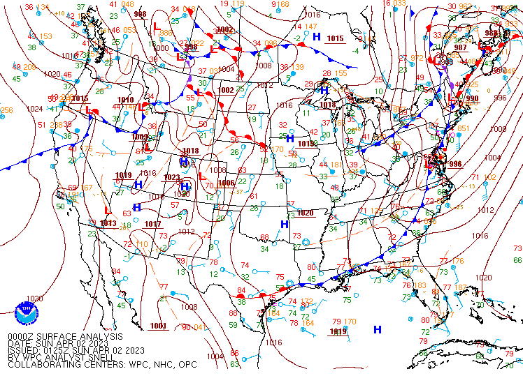 |
| Figure 16: 21z surface map | Figure 17: 00z surface map |
Observed and Forecast Soundings
 |
 |
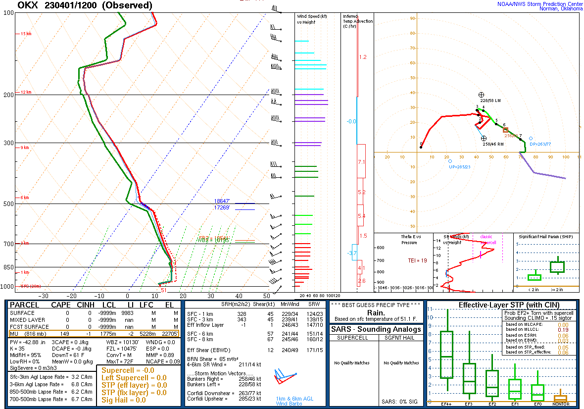 |
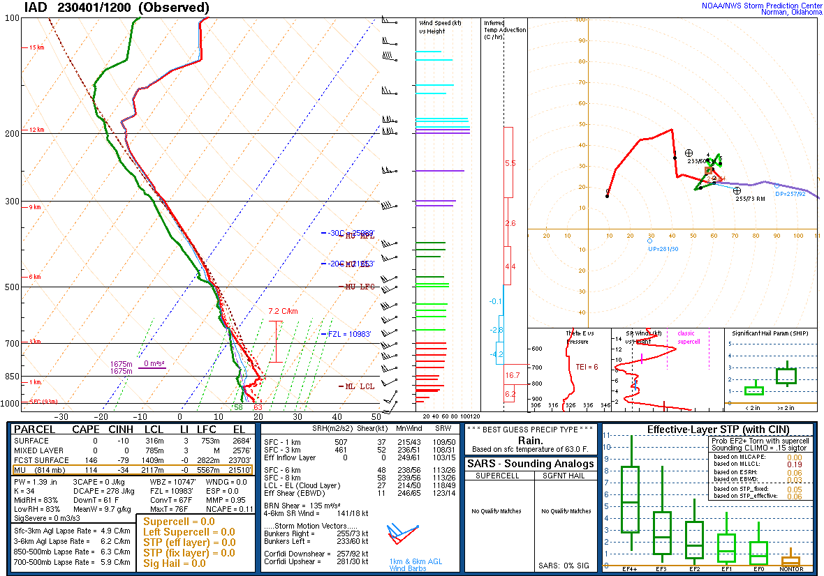
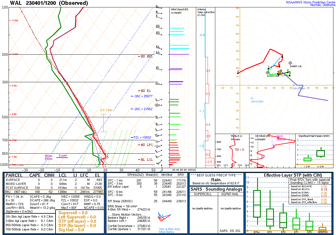
| Figure 18: 12z Sterling, VA sounding | Figure 19: 12z Wallops Island, VA sounding | Figure 20: 12z Upton, NY sounding |
 |
 |
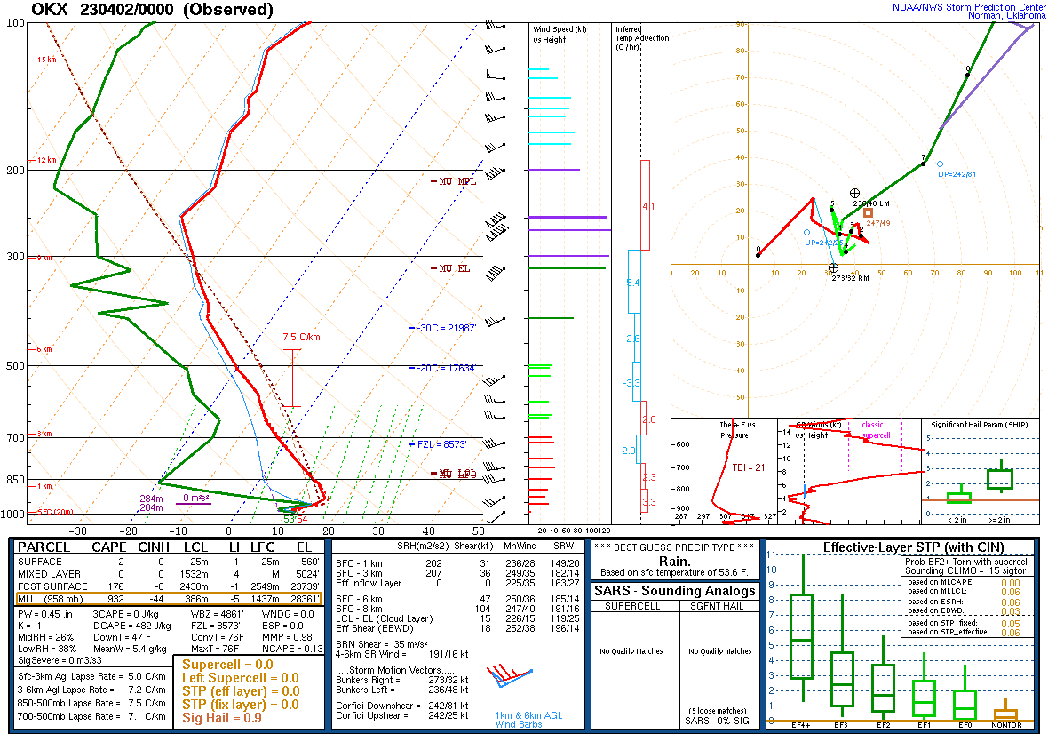 |
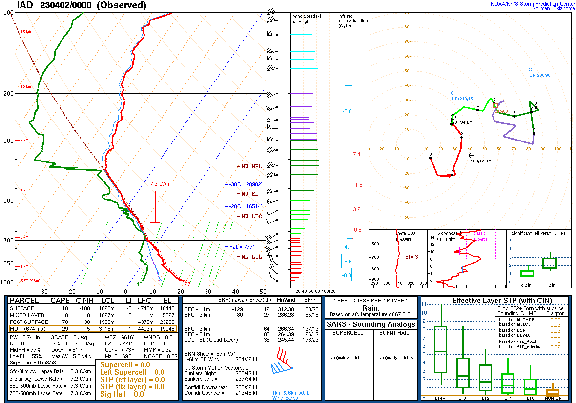
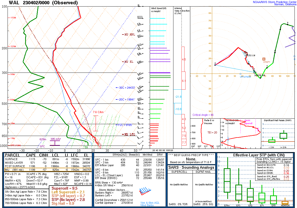
| Figure 21: 00z Sterling, VA sounding | Figure 22: 00z Wallops Island, VA sounding | Figure 23: 00z Upton, NY sounding |
 |
 |
 |
| Figure 1: National Preliminary Reports 12z 01 April 2023 to 12z 02 April 2023 | Figure 2: Zoomed Preliminary Reports for the same period. | Figure 3: Evolution of SPC outlooks leading into this event, beginning with an initial indication of severe weather potential on the Day 3 outlook for April 1st. |
|
Timeline of Watches and Mesoscale Discussions Issued
|
Number of convective warnings issued: Tornado...........................8 Severe Thunderstorm.....17 Special Marine.................6 Flash Flood......................0 Total............................31
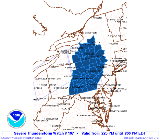
URGENT - IMMEDIATE BROADCAST REQUESTED
   Severe Thunderstorm Watch Number 107
   NWS Storm Prediction Center Norman OK
   225 PM EDT Sat Apr 1 2023

   The NWS Storm Prediction Center has issued a

   * Severe Thunderstorm Watch for portions of
     Central New York
     Central and Eastern Pennsylvania

   * Effective this Saturday afternoon and evening from 225 PM until
     800 PM EDT.

   * Primary threats include...
     Scattered damaging wind gusts to 65 mph possible

   SUMMARY...A fast-moving band of storms will pose mainly a damaging
   wind risk this afternoon.

   The severe thunderstorm watch area is approximately along and 110
   statute miles north and south of a line from 45 miles north
   northwest of State College PA to 20 miles northeast of Wilkesbarre
   PA. For a complete depiction of the watch see the associated watch
   outline update (WOUS64 KWNS WOU7).

   PRECAUTIONARY/PREPAREDNESS ACTIONS...

   REMEMBER...A Severe Thunderstorm Watch means conditions are
   favorable for severe thunderstorms in and close to the watch area.
   Persons in these areas should be on the lookout for threatening
   weather conditions and listen for later statements and possible
   warnings. Severe thunderstorms can and occasionally do produce
   tornadoes.

   &&

   OTHER WATCH INFORMATION...CONTINUE...WW 105...WW 106...

   AVIATION...A few severe thunderstorms with hail surface and aloft to
   1 inch. Extreme turbulence and surface wind gusts to 55 knots. A few
   cumulonimbi with maximum tops to 400. Mean storm motion vector
   26050.

   ...Guyer
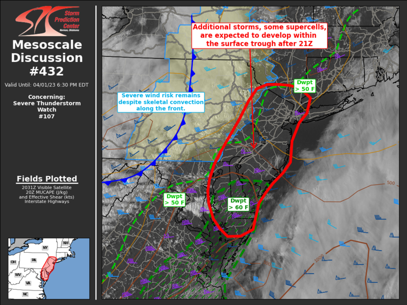
 Mesoscale Discussion 0432
   NWS Storm Prediction Center Norman OK
   0337 PM CDT Sat Apr 01 2023

   Areas affected...parts of eastern Pennsylvania...New
   Jersey...Delaware and eastern Maryland and southern New York

   Concerning...Severe Thunderstorm Watch 107...

   Valid 012037Z - 012230Z

   The severe weather threat for Severe Thunderstorm Watch 107
   continues.

   SUMMARY...Storms may rejuvenate along the front as it moves into
   eastern Pennsylvania and southern New York, with additional develop
   possible ahead of the front from the Delmarva into New Jersey.
   Damaging winds are likely, with a risk of isolated tornadoes and
   large hail by early evening.

   DISCUSSION...Showers and embedded thunderstorms continue to move
   rapidly east with the cold front, with a relative decrease in severe
   wind gusts compared to earlier in the day, due in part to limited
   moisture. East of the ongoing central PA/NY activity, temperatures
   continue to warm, with a recent trend of a few stations reporting
   rising dewpoints across southern NJ and far southeast PA.

   Satellite imagery shows increasing CU over parts of MD, though this
   activity is currently shallow. Over the next 1-2 hours, additional
   storms are expected to form from the Delmarva across far eastern PA
   and into NJ, as lift increases. Some storms may become supercells,
   and the tornado risk will also increase through early evening
   coincident with strengthening low-level shear and cooling aloft. Any
   increase in dewpoints will also increase the probability of a
   tornado. Activity may become linear as the cold front overtakes any
   activity ahead of it, with both damaging winds possible across
   southern NY and New England.

   ..Jewell/Guyer.. 04/01/2023
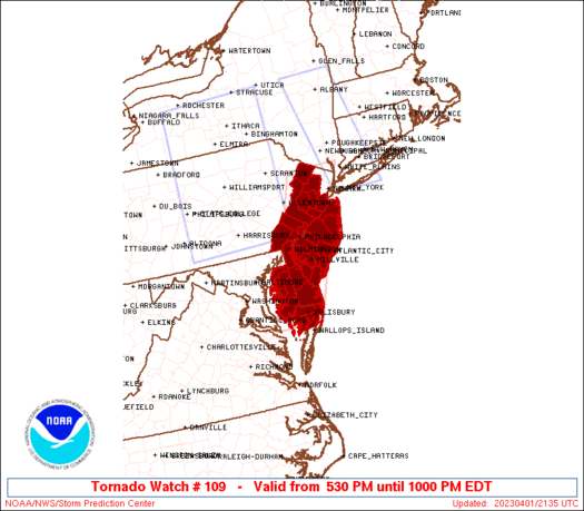
  BULLETIN - IMMEDIATE BROADCAST REQUESTED
   TORNADO WATCH OUTLINE UPDATE FOR WT 109
   NWS STORM PREDICTION CENTER NORMAN OK
   530 PM EDT SAT APR 1 2023

   TORNADO WATCH 109 IS IN EFFECT UNTIL 1000 PM EDT FOR THE
    FOLLOWING LOCATIONS

   DEC001-003-005-020200-
   /O.NEW.KWNS.TO.A.0109.230401T2130Z-230402T0200Z/

   DE
   .    DELAWARE COUNTIES INCLUDED ARE

   KENT                 NEW CASTLE          SUSSEX


   MDC011-019-029-035-039-041-045-047-020200-
   /O.NEW.KWNS.TO.A.0109.230401T2130Z-230402T0200Z/

   MD
   .    MARYLAND COUNTIES INCLUDED ARE

   CAROLINE             DORCHESTER          KENT
   QUEEN ANNE'S         SOMERSET            TALBOT
   WICOMICO             WORCESTER


   NJC001-005-007-009-011-015-019-021-023-025-027-029-033-035-037-
   041-020200-
   /O.NEW.KWNS.TO.A.0109.230401T2130Z-230402T0200Z/

   NJ
   .    NEW JERSEY COUNTIES INCLUDED ARE

   ATLANTIC             BURLINGTON          CAMDEN
   CAPE MAY             CUMBERLAND          GLOUCESTER
   HUNTERDON            MERCER              MIDDLESEX
   MONMOUTH             MORRIS              OCEAN
   SALEM                SOMERSET            SUSSEX
   WARREN


   PAC017-029-045-091-101-020200-
   /O.NEW.KWNS.TO.A.0109.230401T2130Z-230402T0200Z/

   PA
   .    PENNSYLVANIA COUNTIES INCLUDED ARE

   BUCKS                CHESTER             DELAWARE
   MONTGOMERY           PHILADELPHIA


   ANZ430-431-020200-
   /O.NEW.KWNS.TO.A.0109.230401T2130Z-230402T0200Z/

   CW
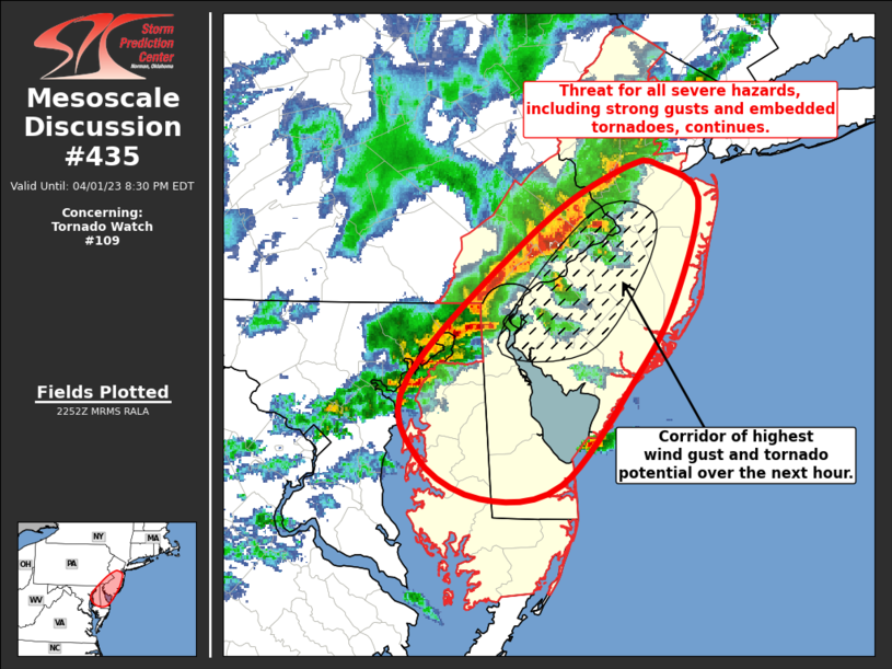
 Mesoscale Discussion 0435
   NWS Storm Prediction Center Norman OK
   0555 PM CDT Sat Apr 01 2023

   Areas affected...Far Eastern PA...Central/Southern NJ...Eastern
   MD...DE

   Concerning...Tornado Watch 109...

   Valid 012255Z - 020030Z

   The severe weather threat for Tornado Watch 109 continues.

   SUMMARY...Threat for severe thunderstorms capable of all severe
   hazards, including damaging gusts and embedded tornadoes, continues.

   DISCUSSION...Ongoing convective line has strengthened over the past
   hour as it moves through the more buoyant air mass in place across
   the northern Mid-Atlantic Coast. Modest buoyancy persists downstream
   of the line across far east-central PA, NJ, eastern MD, and DE where
   temperatures remain in the 70s and dewpoints in the mid 50s.
   Vertical shear also remains strong throughout this region, with
   recent VAD profiles from DOX sampling over 70 kt of 0-6 km bulk
   shear. This combination of buoyancy and deep-layer shear should
   support a continued risk for strong to severe thunderstorms.
   Additionally, area VAD profiles at DIX and DOX also show notable
   low-level veering, which could support an embedded tornado or two
   over the next hour or so.

   Recent radar imagery has shown a trend toward forward propagation,
   particularly towards central/southern NJ, where a corridor of
   greater risk for damaging gusts may be developing.

   ..Mosier.. 04/01/2023
|
NWUS51 KPHI 020224 LSRPHI PRELIMINARY LOCAL STORM REPORT...SUMMARY NATIONAL WEATHER SERVICE MOUNT HOLLY NJ 1024 PM EDT SAT APR 1 2023 ..TIME... ...EVENT... ...CITY LOCATION... ...LAT.LON... ..DATE... ....MAG.... ..COUNTY LOCATION..ST.. ...SOURCE.... ..REMARKS.. 0531 PM HAIL 3 SE WEISENBERG TWP 40.57N 75.71W 04/01/2023 U0.50 INCH LEHIGH PA PUBLIC REPORT FROM MPING: HALF-INCH (0.50 IN.). 0601 PM TORNADO 2 WNW BRIDGEVILLE 38.76N 75.63W 04/01/2023 SUSSEX DE EMERGENCY MNGR REPORTS OF TREES AND WIRES DOWNED NEAR SEASHORE HIGHWAY ROUTE 404 AND DUBLIN HILL ROAD. LIKELY TORNADO. TIME ESTIMATED VIA RADAR. 0602 PM TSTM WND DMG 1 N BRIDGEVILLE 38.76N 75.60W 04/01/2023 SUSSEX DE BROADCAST MEDIA REPORT OF TRAIN FLIPPED OVER. TORNADO LIKELY. TIME ESTIMATED VIA RADAR. 0603 PM FUNNEL CLOUD GREENWOOD 38.81N 75.59W 04/01/2023 SUSSEX DE TRAINED SPOTTER TRAINED SPOTTER REPORTS FUNNEL CLOUD AT 6:03 PM IN GREENWOOD, DE. 0605 PM TSTM WND GST 2 SSE BRIDGEVILLE 38.72N 75.59W 04/01/2023 M98 MPH SUSSEX DE MESONET NANTICOKE RIVER BRIDGE DEOS MESONET MEASURED A 98 MPH GUST LIKELY DUE TO MESONET STATION HIT BY TORNADO. 0606 PM TORNADO 4 SE GREENWOOD 38.77N 75.54W 04/01/2023 SUSSEX DE EMERGENCY MNGR SUSSEX EM REPORTS A CONFINED SPACE RESCUE IN THE VICINITY OF TUCKER ROAD. LIKELY TORNADO. TIME ESTIMATED VIA RADAR. 0608 PM FUNNEL CLOUD 4 S HOUSTON 38.87N 75.50W 04/01/2023 SUSSEX DE PUBLIC 0611 PM TSTM WND DMG 1 W ELLENDALE 38.81N 75.44W 04/01/2023 SUSSEX DE BROADCAST MEDIA REPORTS OF OFF AND ON TREE DAMAGE FROM ROUTE 13 TO ROUTE 113. TORNADO LIKELY. TIME ESTIMATED VIA RADAR. 0618 PM FUNNEL CLOUD 1 SW GEORGETOWN 38.68N 75.40W 04/01/2023 SUSSEX DE PUBLIC 0620 PM HAIL NEWARK 39.68N 75.76W 04/01/2023 M0.70 INCH NEW CASTLE DE TRAINED SPOTTER DIME SIZED HAIL REPORT IN NEWARK, DE. TIME ESTIMATED VIA RADAR. 0624 PM HAIL STANTON 39.72N 75.65W 04/01/2023 M0.70 INCH NEW CASTLE DE TRAINED SPOTTER DIME SIZED HAIL IN STANTON, DE. TIME GIVEN IN REPORT. 0625 PM HAIL LANSDALE 40.24N 75.29W 04/01/2023 M0.70 INCH MONTGOMERY PA PUBLIC PUBLIC REPORTS BRIEF PERIOD OF DIME SIZED HAIL IN LANSDALE. 0625 PM HAIL MALVERN 40.04N 75.51W 04/01/2023 M0.70 INCH CHESTER PA PUBLIC 0630 PM TSTM WND DMG HONEY BROOK 40.10N 75.91W 04/01/2023 CHESTER PA PUBLIC PICTURE OF LARGE TREES DOWNED IN HONEY BROOK, PA. TIME ESTIMATED VIA RADAR. 0635 PM HAIL 1 W EAST WHITELAND TWP 40.05N 75.57W 04/01/2023 E0.25 INCH CHESTER PA PUBLIC 0639 PM HAIL 1 SW DOWNINGTON 40.00N 75.72W 04/01/2023 U0.50 INCH CHESTER PA PUBLIC REPORT FROM MPING: HALF-INCH (0.50 IN.). 0640 PM TSTM WND DMG 1 SW WHITEMARSH TWP 40.08N 75.27W 04/01/2023 MONTGOMERY PA EMERGENCY MNGR LARGE TREE DOWN ON BARREN HILL ROAD JUST WEST OF RIDGE PIKE. 0640 PM HAIL 2 SSE UPPER UWCHLAN TWP 40.05N 75.67W 04/01/2023 M1.00 INCH CHESTER PA PUBLIC REPORT FROM MPING: QUARTER (1.00 IN.). 0642 PM TSTM WND DMG 1 NE KING OF PRUSSIA 40.10N 75.37W 04/01/2023 MONTGOMERY PA DEPT OF HIGHWAYS US-422 CLOSED IN BOTH DIRECTIONS BETWEEN THE PA-23 BRIDGEPORT AND PA 363 AT AUDUBON EXITS IN UPPER MERION TOWNSHIP, MONTGOMERY COUNTY DUE TO DOWNED UTILITY LINES. TIME ESTIMATED VIA RADAR. 0643 PM LIGHTNING 1 W WEST NORRITON 40.13N 75.41W 04/01/2023 MONTGOMERY PA TRAINED SPOTTER SPOTTER REPORTED LIGHTNING STRIKE THAT DESTROYED POLE AND DOWNED WIRES. TIME ESTIMATED VIA RADAR. 0643 PM HAIL 1 W KING OF PRUSSIA 40.08N 75.41W 04/01/2023 U0.50 INCH MONTGOMERY PA PUBLIC REPORT FROM MPING: HALF-INCH (0.50 IN.). 0644 PM HAIL OXFORD 39.78N 75.97W 04/01/2023 U0.50 INCH CHESTER PA PUBLIC REPORT FROM MPING: HALF-INCH (0.50 IN.). 0646 PM HAIL 1 S KING OF PRUSSIA 40.07N 75.39W 04/01/2023 U0.50 INCH MONTGOMERY PA PUBLIC REPORT FROM MPING: HALF-INCH (0.50 IN.). 0648 PM TSTM WND DMG 1 WNW CHESTNUT HILL 40.08N 75.23W 04/01/2023 PHILADELPHIA PA EMERGENCY MNGR LARGE TREE DOWNED BLOCKING BELLS MILL ROAD IN ANDORRA SECTION OF PHILADELPHIA COUNTY. TIME ESTIMATED VIA RADAR. 0648 PM TSTM WND DMG COLONIAL HEIGHTS 39.75N 75.58W 04/01/2023 NEW CASTLE DE EMERGENCY MNGR TREE INTO HOUSE ON NORTH CLEVELAND ROAD. TIME ESTIMATED VIA RADAR. 0649 PM TSTM WND GST LOWER MORELAND TWP 40.13N 75.06W 04/01/2023 M68 MPH MONTGOMERY PA PUBLIC 0649 PM HAIL 1 E GLASGOW 39.60N 75.73W 04/01/2023 U0.50 INCH NEW CASTLE DE PUBLIC REPORT FROM MPING: HALF-INCH (0.50 IN.). 0650 PM TSTM WND DMG NEWARK 39.68N 75.76W 04/01/2023 NEW CASTLE DE EMERGENCY MNGR MULTIPLE TREES INTO HOUSES REPORTED IN NEWARK. TIME ESTIMATED VIA RADAR. 0650 PM HAIL 1 E GLASGOW 39.60N 75.73W 04/01/2023 U0.50 INCH NEW CASTLE DE PUBLIC REPORT FROM MPING: HALF-INCH (0.50 IN.). 0651 PM TSTM WND DMG LANGHORNE 40.18N 74.92W 04/01/2023 BUCKS PA PUBLIC PICTURES OF TREES AND FENCING DOWN IN LANGHORNE, PA. TIME ESTIMATED VIA RADAR. 0654 PM HAIL LOWER MAKEFIELD TWP 40.22N 74.84W 04/01/2023 M1.00 INCH BUCKS PA PUBLIC PICTURE OF QUARTER SIZED HAIL IN LOWER MAKEFIELD TOWNSHIP. TIME ESTIMATED VIA RADAR. 0654 PM HAIL MORRISVILLE 40.21N 74.78W 04/01/2023 M1.00 INCH BUCKS PA TRAINED SPOTTER QUARTER SIZED HAIL PICTURES FROM TRAINED SPOTTER. 0658 PM TSTM WND DMG 2 NNE EWING 40.29N 74.79W 04/01/2023 MERCER NJ NWS EMPLOYEE REPORT OF LARGE TREE DOWN BLOCKING THE OFFRAMP ON I-295 TO ROUTE 31. TIME ESTIMATED VIA RADAR. 0700 PM TSTM WND DMG CASTLE HILLS 39.69N 75.56W 04/01/2023 NEW CASTLE DE EMERGENCY MNGR TREES DOWN INTO A HOUSE ON WARDOR AVE. TIME ESTIMATED VIA RADAR. 0701 PM HAIL 1 N YARDLEY 40.26N 74.84W 04/01/2023 U0.50 INCH MERCER NJ PUBLIC REPORT FROM MPING: HALF-INCH (0.50 IN.). 0702 PM HAIL 2 W NORTHEAST PHILADELP 40.10N 75.05W 04/01/2023 U0.50 INCH PHILADELPHIA PA PUBLIC REPORT FROM MPING: HALF-INCH (0.50 IN.). 0705 PM TSTM WND GST MOORESTOWN 39.98N 74.90W 04/01/2023 M60 MPH BURLINGTON NJ MESONET 0705 PM TSTM WND DMG 1 E NEW ALBANY 40.00N 74.96W 04/01/2023 BURLINGTON NJ TRAINED SPOTTER LARGE AMOUNT OF TREE DAMAGE FROM RIVERTON COUNTRY CLUB ALONG A STRAIGHT LINE TO PARRY ROAD, TENBY CHASE DRIVE, AND HAINES MILL ROAD IN DELRAN. TORNADO POSSIBLE. TIME ESTIMATED VIA RADAR. 0706 PM TSTM WND DMG SOUTH BRUNSWICK TWP 40.38N 74.53W 04/01/2023 MIDDLESEX NJ LAW ENFORCEMENT LARGE TREES DOWNED BLOCKING MAJOR ROAD. TIME ESTIMATED VIA RADAR. 0706 PM HAIL MERCERVILLE 40.24N 74.69W 04/01/2023 M1.00 INCH MERCER NJ TRAINED SPOTTER TIME ESTIMATED VIA RADAR. 0706 PM TSTM WND DMG 2 ESE TRENTON 40.20N 74.74W 04/01/2023 MERCER NJ PUBLIC PICTURES OF LARGE TREES DOWNED ON LALOR STREET IN HAMILTON, NJ. TIME ESTIMATED VIA RADAR. 0706 PM TSTM WND GST 1 WNW BURLINGTON 40.08N 74.87W 04/01/2023 M65 MPH BURLINGTON NJ PUBLIC TIME ESTIMATED VIA RADAR. 0707 PM TSTM WND GST PHILADELPHIA INTERNATIO 39.88N 75.22W 04/01/2023 M62 MPH PHILADELPHIA PA ASOS 0707 PM TSTM WND DMG PENNSVILLE 39.65N 75.52W 04/01/2023 SALEM NJ TRAINED SPOTTER TREE DOWN ON RIVIERA DRIVE NEAR BOSTON ROAD. TIME ESTIMATED VIA RADAR. 0708 PM TSTM WND DMG 1 E NEW ALBANY 40.00N 74.96W 04/01/2023 BURLINGTON NJ PUBLIC PICTURES OF TREES AND FENCES DOWNED. TIME ESTIMATED VIA RADAR. 0710 PM TSTM WND GST YARDVILLE 40.18N 74.66W 04/01/2023 M71 MPH MERCER NJ TRAINED SPOTTER 0710 PM HAIL EWING 40.27N 74.80W 04/01/2023 M1.00 INCH MERCER NJ TRAINED SPOTTER QUARTER SIZED HAIL IN EWING FROM TRAINED SPOTTER. TIME GIVEN IN REPORT. 0710 PM HAIL GREEN RIDGE 39.87N 75.42W 04/01/2023 U0.50 INCH DELAWARE PA PUBLIC REPORT FROM MPING: HALF-INCH (0.50 IN.). 0711 PM HAIL FELLOWSHIP 39.93N 74.96W 04/01/2023 U0.50 INCH BURLINGTON NJ PUBLIC REPORT FROM MPING: HALF-INCH (0.50 IN.). 0712 PM TSTM WND DMG 1 NE CINNAMINSON 40.00N 74.99W 04/01/2023 BURLINGTON NJ NWS EMPLOYEE LARGE AMOUNT OF TREES DOWN IN THE NEIGHBORHOOD AROUND LOCUST LANE. TIME ESTIMATED VIA RADAR. 0712 PM TSTM WND DMG CINNAMINSON 40.00N 74.99W 04/01/2023 BURLINGTON NJ NWS EMPLOYEE TREES BLOCKING RIVERTON ROAD. TIME ESTIMATED VIA RADAR. 0715 PM TSTM WND DMG STEVENSVILLE 38.99N 76.31W 04/01/2023 QUEEN ANNE'S MD 911 CALL CENTER REPORT OF A TREE BLOWN DOWN INTO A HOUSE. TIME ESTIMATED FROM RADAR. 0715 PM TSTM WND DMG CHESTERTOWN 39.22N 76.07W 04/01/2023 KENT MD 911 CALL CENTER REPORTS OF SEVERAL TREES DOWN ACROSS KENT COUNTY. TIME ESTIMATED FROM RADAR. 0715 PM TSTM WND GST 2 SSW ROCK HALL 39.12N 76.25W 04/01/2023 M60 MPH KENT MD MESONET HUNTINGFIELD POINT MEASURED WIND GUST TO 60 MPH AT 7:15 PM. 0716 PM HAIL 1 E LAWNDALE 40.04N 75.07W 04/01/2023 E0.50 INCH PHILADELPHIA PA PUBLIC 0716 PM HAIL 1 E KING OF PRUSSIA 40.09N 75.37W 04/01/2023 E0.50 INCH MONTGOMERY PA PUBLIC 0717 PM TSTM WND GST WOODSTOWN 39.65N 75.32W 04/01/2023 M60 MPH SALEM NJ TRAINED SPOTTER TRAINED SPOTTER REPORTS 60 MPH GUST. TIME ESTIMATED VIA RADAR. 0718 PM TSTM WND DMG 1 NNE ELLISBURG 39.93N 74.99W 04/01/2023 CAMDEN NJ TRAINED SPOTTER TREES DOWNED ON SPRINGDALE ROAD NEAR CHURCH ROAD AND ROUTE 70. 0720 PM HAIL 2 S JACOBSTOWN 40.05N 74.59W 04/01/2023 E0.25 INCH BURLINGTON NJ PUBLIC 0721 PM HAIL ALLENTOWN 40.18N 74.58W 04/01/2023 U1.50 INCH MONMOUTH NJ PUBLIC REPORT FROM MPING: PING PONG BALL (1.50 IN.). 0721 PM HAIL 1 E LUMBERTON TWP 39.96N 74.80W 04/01/2023 U0.50 INCH BURLINGTON NJ PUBLIC REPORT FROM MPING: HALF-INCH (0.50 IN.). 0723 PM HAIL 1 SW VINCENTOWN 39.93N 74.76W 04/01/2023 U0.50 INCH BURLINGTON NJ PUBLIC REPORT FROM MPING: HALF-INCH (0.50 IN.). 0724 PM TSTM WND DMG 1 S IMLAYSTOWN 40.15N 74.52W 04/01/2023 MONMOUTH NJ PUBLIC TREES AND WIRES DOWN ON DAVIS STATION ROAD IN UPPER FREEHOLD. POSSIBLE TORNADO. TIME ESTIMATED VIA RADAR. 0726 PM HAIL 2 SE EASTAMPTON TWP 39.97N 74.74W 04/01/2023 U0.75 INCH BURLINGTON NJ PUBLIC REPORT FROM MPING: DIME (0.75 IN.). 0730 PM TSTM WND DMG 1 SW HOWELL 40.15N 74.23W 04/01/2023 MONMOUTH NJ PUBLIC PICTURES OF SIGNIFICANT TREE DAMAGE AROUND HOWELL WITH REPORTS OF POWER OUTAGES AND WIRES DOWNED. POSSIBLE TORNADO. TIME ESTIMATED VIA RADAR. 0730 PM MARINE TSTM WIND 6 ESE WOODLAND BEACH 39.31N 75.38W 04/01/2023 M60 MPH ANZ430 DE OTHER FEDERAL SHIP JOHN SHOAL. 0730 PM HAIL 1 SW PITMAN 39.72N 75.13W 04/01/2023 U0.75 INCH GLOUCESTER NJ PUBLIC REPORT FROM MPING: DIME (0.75 IN.). 0732 PM TSTM WND DMG 2 SSW HOWELL 40.14N 74.23W 04/01/2023 MONMOUTH NJ BROADCAST MEDIA REPORT OF GAZEBO LIFTED FROM PORCH. TORNADO POSSIBLE. TIME ESTIMATED VIA RADAR. 0733 PM TSTM WND GST 1 NW LAKEWOOD 40.08N 74.18W 04/01/2023 M62 MPH OCEAN NJ TRAINED SPOTTER 0733 PM HAIL 2 WSW LAKEWOOD TWP 40.08N 74.25W 04/01/2023 M1.00 INCH OCEAN NJ TRAINED SPOTTER 0733 PM TSTM WND DMG HOWELL 40.16N 74.23W 04/01/2023 MONMOUTH NJ PUBLIC PICTURES OF LARGE TREES DOWNED ON LAKE DRIVE AND ALDRICH DRIVE IN HOWELL. POSSIBLE TORNADO. TIME ESTIMATED VIA RADAR. 0738 PM TSTM WND GST 5 W LAKEHURST 40.03N 74.39W 04/01/2023 M58 MPH OCEAN NJ ASOS 0740 PM TSTM WND DMG 1 W RAMTOWN 40.12N 74.17W 04/01/2023 MONMOUTH NJ PUBLIC TREES SNAPPED AND LARGE BRANCHES DOWN. A VEHICLE WAS DAMAGED. PROBABLE TORNADO. 0741 PM TSTM WND GST 3 ESE FARMINGDALE 40.19N 74.12W 04/01/2023 M61 MPH MONMOUTH NJ AWOS 0741 PM MARINE TSTM WIND 1 SSW POINT PLEASANT 40.05N 74.08W 04/01/2023 M55 MPH ANZ451 NJ TRAINED SPOTTER 0744 PM TSTM WND GST MILLVILLE MUNICIPAL AIR 39.37N 75.07W 04/01/2023 M58 MPH CUMBERLAND NJ ASOS 0750 PM TSTM WND GST COLTS NECK 40.29N 74.18W 04/01/2023 M58 MPH MONMOUTH NJ PUBLIC TIME ESTIMATED VIA RADAR. 0750 PM HAIL 3 SE RAMTOWN 40.10N 74.11W 04/01/2023 U0.75 INCH OCEAN NJ PUBLIC REPORT FROM MPING: DIME (0.75 IN.). 0755 PM HAIL FARMINGTON 38.87N 75.58W 04/01/2023 M1.00 INCH KENT DE TRAINED SPOTTER TIME GIVEN IN REPORT. 0757 PM HAIL ASBURY PARK 40.22N 74.01W 04/01/2023 U1.00 INCH MONMOUTH NJ PUBLIC REPORT FROM MPING: QUARTER (1.00 IN.). 0759 PM MARINE TSTM WIND 2 S ISLAND BEACH STATE 39.85N 74.09W 04/01/2023 M38 MPH OCEAN NJ MESONET 0804 PM TSTM WND GST ATLANTIC CITY INTERNATI 39.45N 74.57W 04/01/2023 M60 MPH ATLANTIC NJ ASOS 0805 PM MARINE TSTM WIND SURF CITY 39.66N 74.17W 04/01/2023 M59 MPH OCEAN NJ MESONET WUNDERGROUND STATION KNJSURFC12. 0805 PM TSTM WND GST SURF CITY 39.66N 74.17W 04/01/2023 M59 MPH OCEAN NJ PUBLIC WUNDERGROUND STATION KNJSURFC12. 0809 PM WATER SPOUT 1 SE ATLANTIC CITY 39.36N 74.40W 04/01/2023 ANZ452 NJ BROADCAST MEDIA BROADCAST MEDIA PASSES ALONG PICTURE OF FUNNEL CLOUD NEAR THE NORTHERN EDGE OF ATLANTIC CITY. TIME ESTIMATED VIA RADAR. 0812 PM MARINE TSTM WIND 1 SSW NORTH CAPE MAY 38.97N 74.96W 04/01/2023 M45 MPH CAPE MAY NJ OTHER FEDERAL 0812 PM TSTM WND DMG 3 ESE DENNISVILLE 39.18N 74.76W 04/01/2023 CAPE MAY NJ TRAINED SPOTTER MULTIPLE TREES DOWNED ON CORSON TAVERN ROAD AND ROUTE 9. TIME ESTIMATED VIA RADAR. 0812 PM LIGHTNING 1 WNW RIO GRANDE 39.02N 74.89W 04/01/2023 CAPE MAY NJ TRAINED SPOTTER STRUCTURE FIRE CAUSED BY LIGHTNING. TIME ESTIMATED VIA RADAR. 0840 PM MARINE TSTM WIND DEWEY BEACH 38.69N 75.08W 04/01/2023 M51 MPH ANZ455 DE MESONET 0909 PM MARINE TSTM WIND 8 ESE EAST LONG BRANCH 40.27N 73.84W 04/01/2023 M40 MPH ANZ450 NJ BUOY CORRECTS PREVIOUS MARINE TSTM WIND REPORT FROM 10 E EAST LONG BRANCH. BUOY 65 MEASURED GUST. 0915 PM NON-TSTM WND GST 1 WSW VALLEY TWP 39.98N 75.87W 04/01/2023 M48 MPH CHESTER PA AWOS 0925 PM NON-TSTM WND GST 2 SW STEVENSVILLE 38.98N 76.33W 04/01/2023 M58 MPH QUEEN ANNE'S MD AWOS 0931 PM NON-TSTM WND GST 1 SSW RUSCOMBMANOR TWP 40.41N 75.83W 04/01/2023 M53 MPH BERKS PA MESONET CWOP STATION. && $$
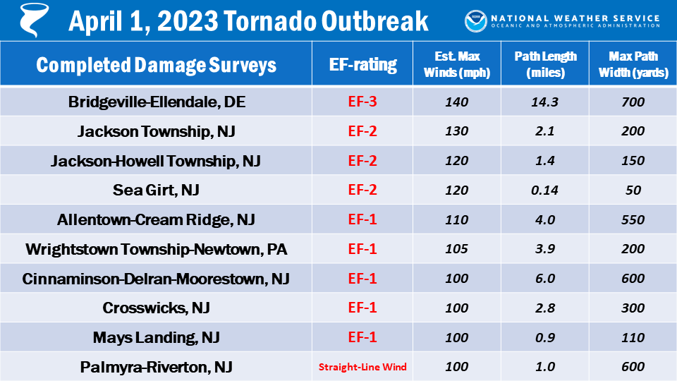
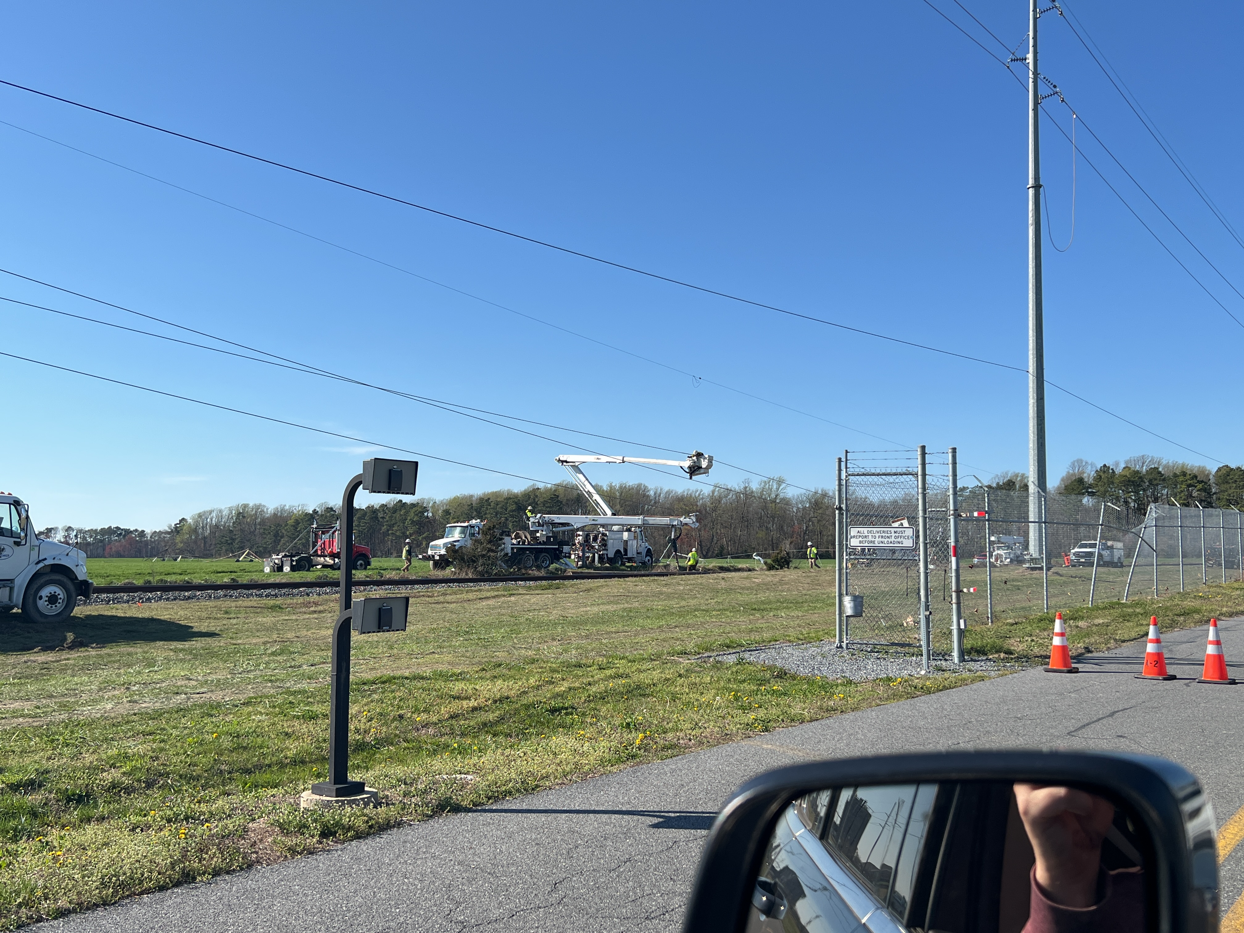
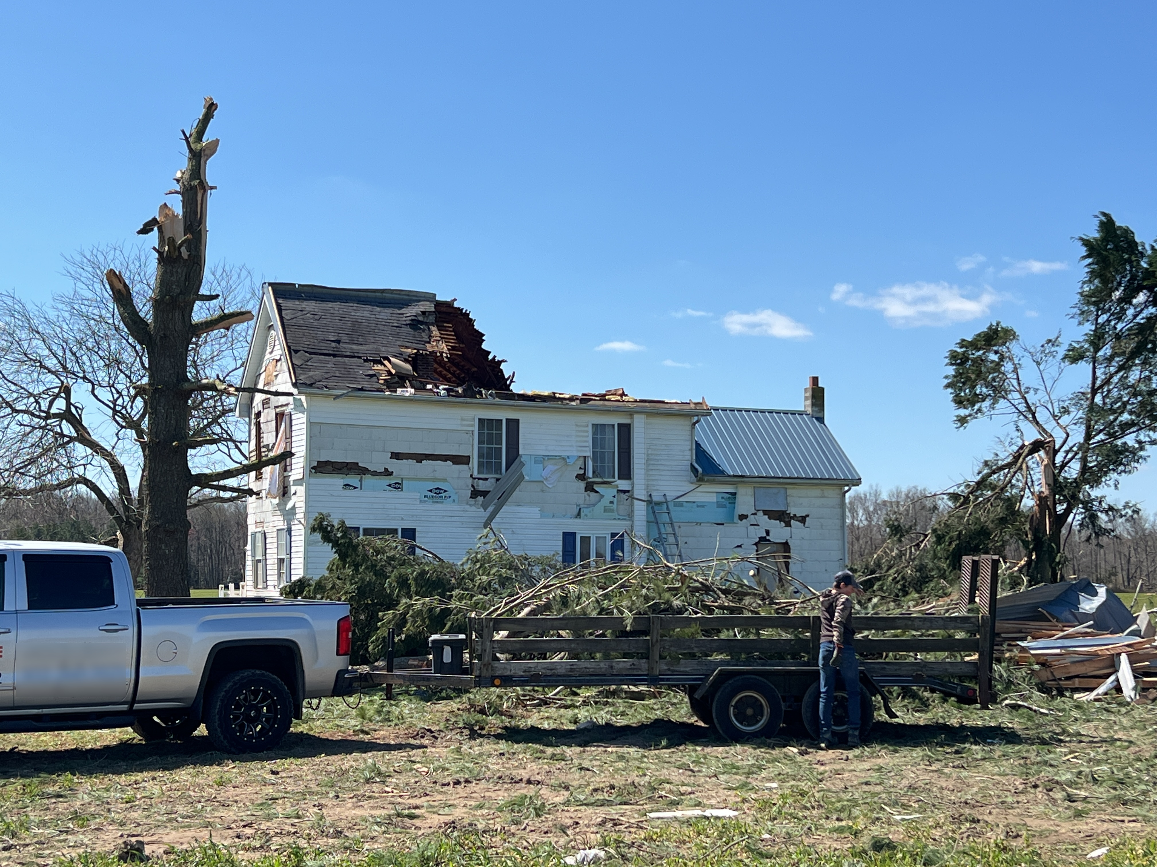
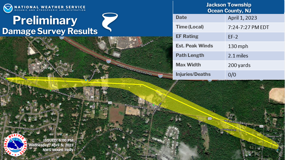
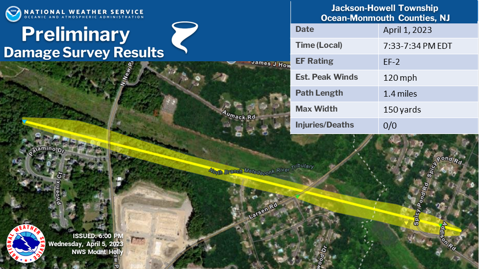
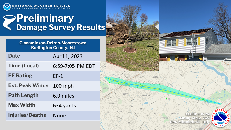
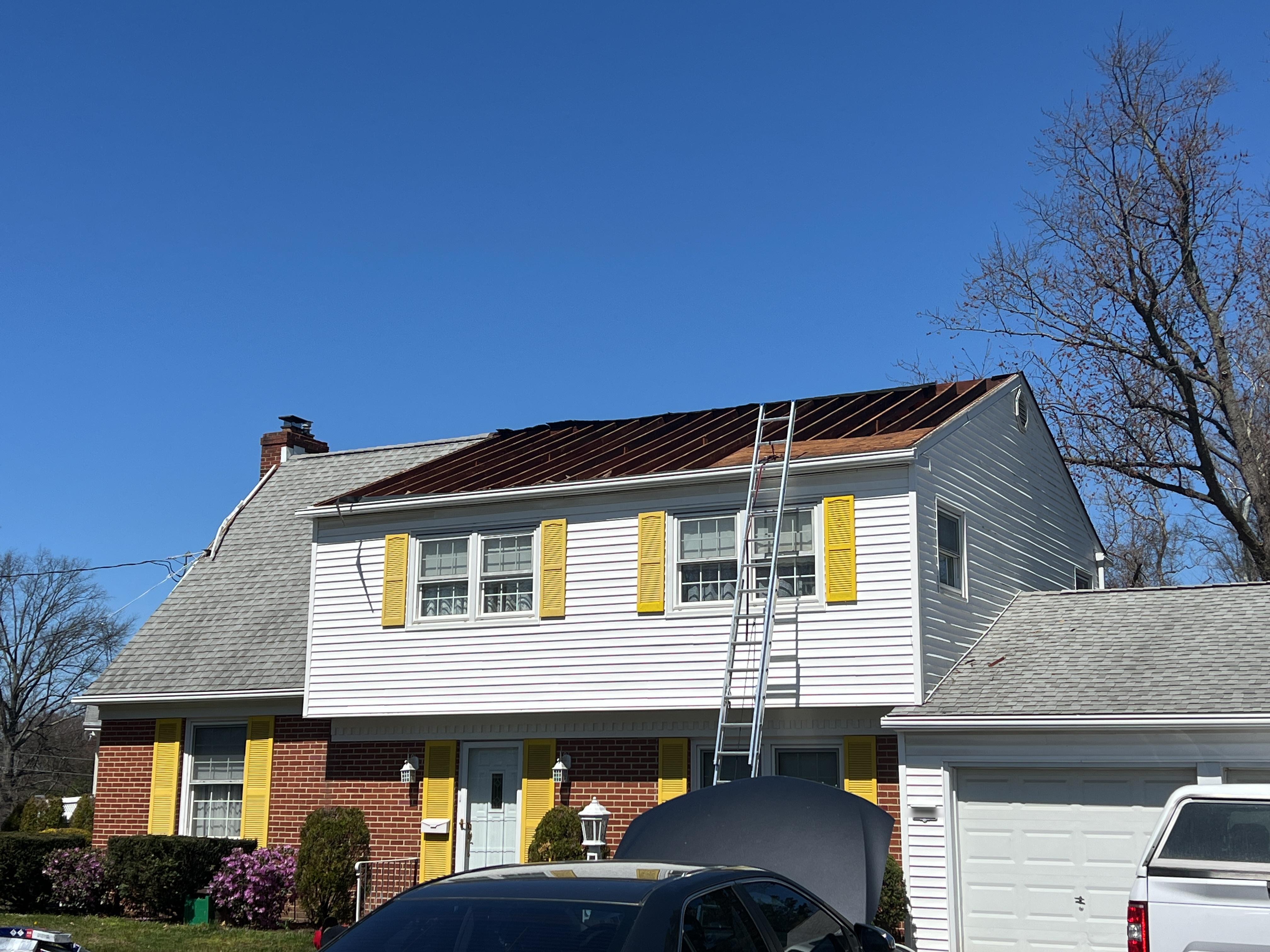
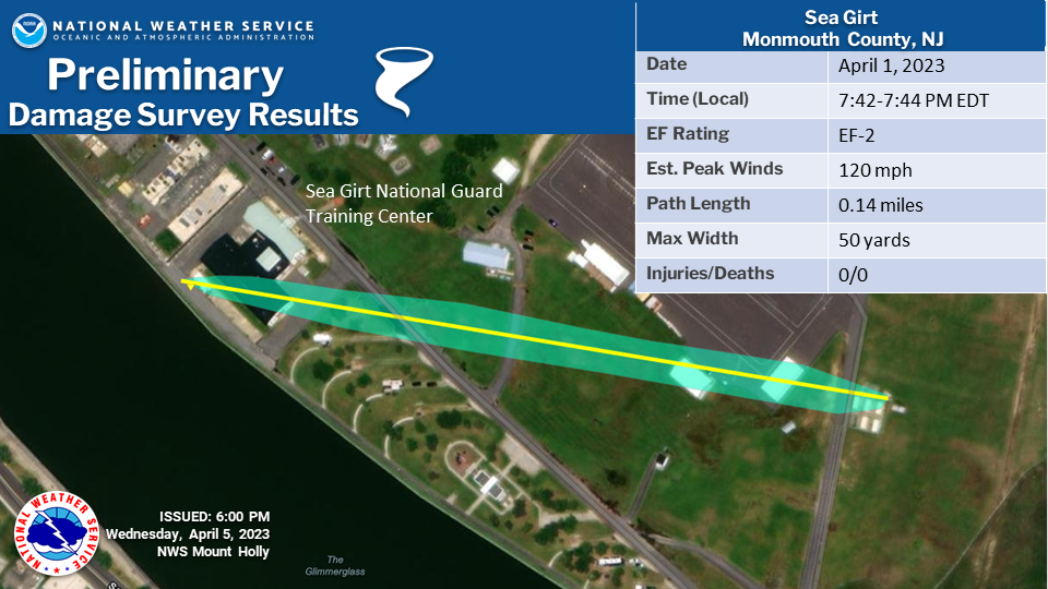
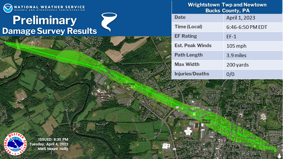
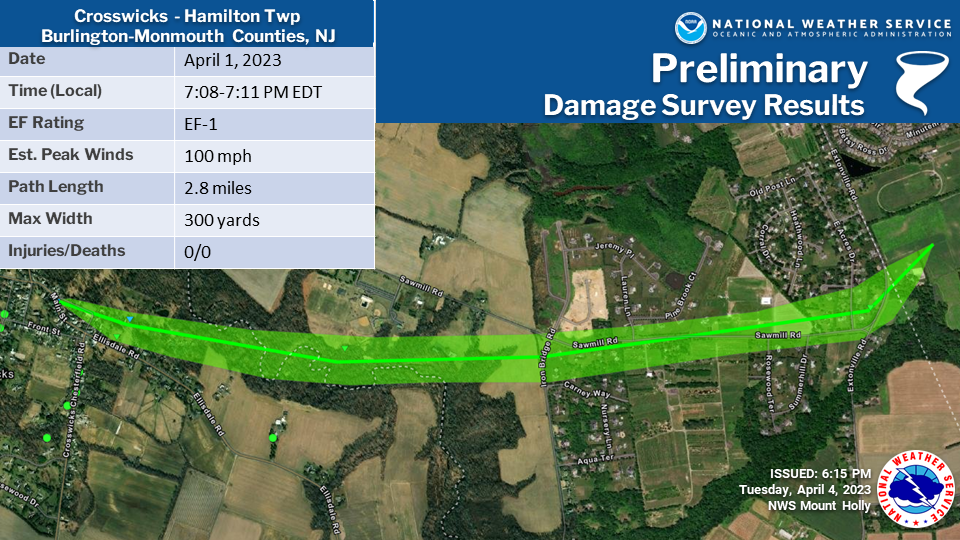
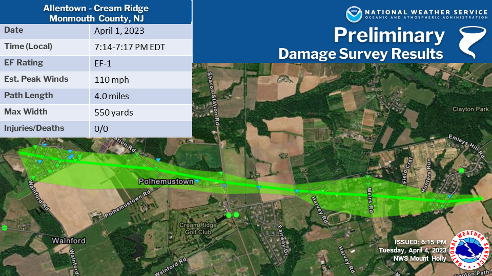
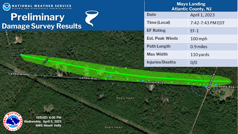
Public Information Statement - TornadoNOUS41 KPHI 071602 PNSPHI DEZ001>004-NJZ010-012>027-PAZ070-071-102-104-106-080415- Public Information Statement National Weather Service Mount Holly NJ 1202 PM EDT Fri Apr 7 2023 ...NWS Damage Surveys for April 1, 2023 Tornado Outbreak and Wind Event... .Update 10...Minor adjustment made to the end point and time for the Cinnaminson-Delran-Moorestown Tornado based on an additional report of damage. .Overview... A line of severe thunderstorms crossed the region Saturday night, April 1, 2023. A total of 9 tornadoes have been confirmed (7 in NJ, 1 in PA and 1 in DE). Tornado statistics for Delaware since 1950: The only other recorded fatality in a tornado in Delaware occurred with an F2 tornado on July 21, 1983 near Hartley in Kent County. The strongest tornado on record in Delaware struck on April 28, 1961 in New Castle. It had an F3 rating based upon it having destroyed a 13-inch wall of a warehouse and having tossed large doors from the warehouse two blocks away. It also damaged several house roofs. The longest track tornado on record in Delaware struck Kent and New Castle Counties on August 4, 2020 during Tropical Storm Isaias. It traveled 35.5 miles from the area of Dover to near Glasgow and had an intensity of EF2. The two widest tornadoes previously on record in Delaware were the EF2 tornadoes which struck the state on August 4, 2020 during Tropical Storm Isaias, both of which had widths of 500 yards. Historically, Delaware has gone multiple years without any tornadoes, only to then have multiple occur in a short time. There were no tornadoes for about a 7 year period between September 28, 2004 and August 27, 2011. Delaware had 5 tornadoes in a single day during Tropical Storm Isaias, the most daily on record. The most in a year were 6 in 1992 and 2020. .Bridgeville-Ellendale DE Tornado... Rating: EF-3 Estimated Peak Wind: 140 mph Path Length /statute/: 14.3 miles Path Width /maximum/: 700 yards (0.4 miles) Fatalities: 1 Injuries: 0 Start Date: April 1, 2023 Start Time: 5:59 PM EDT Start Location: Bridgeville / Sussex County / DE Start Lat/Lon: 38.7570 / -75.6398 End Date: April 1, 2023 End Time: 6:19 PM EDT End Location: Ellendale / Sussex County / DE End Lat/Lon: 38.8180 / -75.3892 The Bridgeville-Ellendale Tornado began around 5:59 PM EDT near the intersection of Polk Road and Dublin Hill Road where a section of a small barn roof was blown off. The tornado continued east- northeast crossing Seashore Highway. Along this section of the damage path, a couple wooden power poles were blown down along with several trees uprooted or snapped. On tree fell onto a house causing significant collateral roof damage. The tornado continued eastward paralleling Newton Road where a farmstead sustain significant tree damage. About a half dozen parked semi- trailers were blow over along a driveway. Farther east, more tree damage and snapped power poles were observed. Near the intersection of Precious Lane and Newton Road, a 2 story house was collapsed after appearing to have slid off its foundation. A small outbuilding was also severely damaged nearby. Debris from this area was blown several hundred yards east into nearby fields. Another farmstead was struck by the tornado as it continued east on Dale Farm Road. A large barn had 2 exterior walls blown out and a smaller shed was blown over. Several trees were also snapped or uprooted on the property. The tornado continued east, crossing a railroad track and impacting a Delaware Department of Transportation facility. Along the railroad track, a half dozen or more wooden high tension power poles were snapped and collapsed along with 2 steel high tension power poles. This is where the tornado's estimated peak wind speeds of 140 mph were reached. The DE DOT facility sustained significant damage. A maintenance garage building experienced a collapse of an exterior wall and large portion of its roof. 2 smaller garage buildings nearby experienced several garage doors blown out, roofing material removal, and exterior wall damage. A building storing road salt had it's roof completely destroyed. The facility's office building had a few windows blown out, siding, and roofing material blown off. Some of the siding material was found embedded into the ground downstream where a Delaware Environmental Observing System mesonet gauge measured a 98 mph wind gust at 3 meters (~10 feet) above the ground at 6:05 PM EDT. The tornado continued across a field, then crossed US Route 13 where a few utility poles were snapped. The tornado continued east into a wooded area where significant tree damage occurred. Numerous trees were snapped, one of which fell onto a double-wide manufactured home. After continuing through the wooded area, the tornado emerged into a field along Sugar Hill Road. A house along the road sustained significant roof removal, exterior wall damage, and blown out windows. A small outbuilding sustained roof material removal and several trees near the house were snapped or uprooted. The tornado continued across Sugar Hill Road and east into another field where 2 irrigation pivots were blown over. The tornado emerged into a wooded residential area along Fawn Road where the tornado appeared to have intensified. The tornado cause significant uprooted and snapped trees in the area as well as significant removal of roofing material and blown out windows to some of the single-family houses along Fawn Road. Farther east, the significant tree damage continued and a large detached garage collapsed. The tornado continued northeast toward the northern extension of Fawn Road where more significant tree damage occurred. A single story single family home appeared to have slid off its foundation and collapsed. A few other homes sustained roofing material and other cosmetic material blown off. The tornado continued east into another wooded residential area along Quail Hollow Road where mostly significant tree damage occurred. Numerous trees were snapped or uprooted. One snapped tree fell into a house causing significant collateral damage. On large detached garage was severely damaged with exterior walls and roof collapse near Tuckers Road And Quail Hollow Road. The tornado moved northeast from this area into a wooded area just south of Tuckers Road, emerging into an open field. This was the point where the tornado reached its maximum with of about 700 yards (~0.4 miles). The tornado struck a small farmstead along Tuckers Road. The house appeared to have slide off its foundation and collapsed. 2 barns on the property were completely destroyed along with snapped trees and power poles. Farther east, several homes sustained damage from fallen trees and wind blowing off roof material. A few irrigation pivots were blown over in this area. Numerous trees were snapped or uprooted along Owens Road and Sharps Mill Road near Tuckers Road. Just east of Tuckers Road, a single family house sustained significant structural damage. A large section of roof was blown off and an exterior wall was partially blown out. Several windows were blown out and the vinyl fencing on the property was almost completely blown away. A few more trees and minor cosmetic damage to structures occurred a few hundred yards east of Tuckers Road as the tornado continued northeast. Another residence was struck by the tornado on Tuckers Road where a large portion of exterior wall along the attic was blown off. The home's chimney was also blown off and a few windows were blown out. A detached garage on the property had its roof almost completely blown off. A chicken house behind the residence had a small portion of its roof blown off. Some trees were uprooted along a tree line before the tornado moved into a large and inaccessible wooded area. The tornado appeared to have maintained a fairly steady intensity as it continued northeast toward Ellendale while crossing several roads. The tornado crossed Oak Road, B and R Road, Oakley Road, Union Church Road, and Beaver Dam Road. Along these road crossings, the tornado produced consistent tree damage and some minor cosmetic damage to some homes. More notable areas of damage include: a large chicken house along B and R Road was severely damaged with some collapse of the northern end of the structure; A house along Oakley Road had an exterior garage wall pushed inward; more significant tree damage was also noted along Oakley Road; and a small portion of a single family house was blown off on Beaver Dam Road. The tornado crossed US Route 113 into Ellendale where sporadic tree damage occurred in a residential area along Sharons Road. An entire attached garage roof and walls were blown off on a single family home on Pine Oak Street near Sharons Road. Some other houses sustained roof material blown off in this area. The tornado crossed Beach Highway/Main Street near Old State Road where some minor tree damage occurred and some shingles were blown off of a few homes. The tornado crossed Washington Avenue and McCaulley Avenue where a small portion of roof material was blow off of a free standing garage. The tornado began to weaken considerably moving northeast of downtown Ellendale. It crossed Ponder Road where some roof material was blown off of a automotive service building. The tornado continued into a wooded area then crossed Holly Tree Road emerging into a field. The tornado circulation dissipated around 6:19 PM EDT just after turning over an irrigation pivot near Hummingbird Road and Benson Road. One fatality occurred from this tornado, but no other known serious injuries occurred. The National Weather Service survey team would like to thank the Delaware Emergency Management Agency and Sussex County Emergency Management Agency for their assistance with this survey. .Jackson Township NJ Tornado... Rating: EF-2 Estimated Peak Wind: 130 mph Path Length /statute/: 2.1 miles Path Width /maximum/: 200 yards Fatalities: 0 Injuries: 0 Start Date: April 1, 2023 Start Time: 7:24 PM EDT Start Location: Jackson Township / Ocean County / NJ Start Lat/Lon: 40.1558 / -74.3936 End Date: April 1, 2023 End Time: 7:27 PM EDT End Location: Jackson Township / Ocean County / NJ End Lat/Lon: 40.1494 / -74.3579 A tornado formed from along an eastward moving rotating supercell within a line of thunderstorms and made initial touchdown near Patterson road, off of West Commodore Road, in Jackson Township and continued east for approximately a 3/4 mile long and 200 yard width path across the residences on the north side of Stonehenge Ct and along West Commodore Blvd, before going across the residences and businesses across Wright Debow and Hamilton Rd. Dozens of large hardwood and softwood trees were snapped or uprooted in a convergent pattern, power poles downed or snapped, fences demolished, and sheds, small outbuildings, and dumpsters flipped or moved. Despite the significant tree damage, generally only minor siding and roof shingle damage was noted. This damage was consistent with EF1 winds of 90 to 110 mph. The tornado then likely strengthened to its greatest intensity as it continued east, across a cleared and paved area, to a newly built large warehouse development. The southern half of the warehouse, made up of several 3 story concrete pre-fab tilt-up walls, both on the east and west side, tied together with metal roofing system above, collapsed in an eastward direction. Based on the degree of damage and construction this was determined to be high end EF2 winds of 120 to 130 mph. In addition dozens of hard and soft wood trees on the south and southeast side of the building and east side parking lot were uprooted or trunks snapped laying in a E/NE direction. The tornado continued on, now in an east southeast direction, for about 3/4 mile with about 200 yd path width, just north of GasTime, across Diamond Road and back along West Commodore road, and into the residences around Indiero Lane and Oaktree Lanes. The most extensive tree and powerline damage was seen along West Commodore Road, with hundreds of mature hard and soft wood trees uprooted or snapped in a convergent pattern, numerous power poles downed or snapped, as well as roofing and insulation debris from the warehouse being littered along the way. The tree damage along part of West Commodore Road was consistent with winds of 100 to 120 mph. The tornado appeared to be weakening to EF0 as it entered the residences around Indiero Lane and Oaktree Lanes, south of West Commodore, with the tree damage path becoming scattered and narrowing to 100 yards, and only minor siding and roof shingle damage noted. The tornado likely occluded just before reaching the Land O Pines Mobile Home Park, where the tornado path ended. The National Weather Service would like to thank Jackson Township Emergency Management, Ocean County Emergency Management and New Jersey State Police for their help in this survey. .Jackson-Howell Township NJ Tornado... Rating: EF-2 Estimated Peak Wind: 120 mph Path Length /statute/: 1.4 miles Path Width /maximum/: 150 yards Fatalities: 0 Injuries: 0 Start Date: April 1, 2023 Start Time: 7:33 PM EDT Start Location: Jackson Township / Ocean County / NJ Start Lat/Lon: 40.1539 / -74.2733 End Date: April 1, 2023 End Time: 7:34 PM EDT End Location: Howell Township / Monmouth County / NJ End Lat/Lon: 40.1511 / -74.2557 A tornado formed along an eastward moving rotating supercell within a line of thunderstorms and made an initial touchdown on the north side of Palomino Drive. A 100 yard wide path of dozens of large hardwood and softwood trees were snapped or uprooted in a convergent east to northeast pattern between the north side of Palomino Drive and the high tension powerlines paralleling to the north. In addition to the extensive tree damage, numerous fences were demolished with moderate roof and shingle damage to houses on the north side of Palomino Drive. The path of tree damage continued east southeast, across N New Prospect Rd, and along the north and northeast periphery of the newly built Paragon apartment complex. The degree of tree and home damage is consistent with winds of 100-120 mph. The tornado continued east southeast down to the intersection of Larsen Road and Maplewood Place. Several large hard and soft wood trees were snapped or uprooted in a convergent pattern, and power poles downed, on either side of Larsen at this intersection. The tornado tracked east southeast across the residences along the east side of Maplewood and the northeast section of Dogwood Rd, with about a 150 yd width path of dozens of large trees snapped or uprooted in a convergent pattern, power poles downed or snapped, fences demolished, and sheds flipped or moved. Despite the significant tree damage, generally only minor siding and roof shingle damage was noted. This damage was consistent with EF1 winds of 90 to 110 mph. The tornado likely moved southeast from here across a shallow NE to SW cleared valley area along the Monmouth/Ocean county border with transmission lines running through. No damage was noted to the transmission lines or the metal truss towers. The tornado then likely strengthened to its greatest intensity as it continued east southeast from the clearing to the residences on the southwest corner of Spicy Pond Rd. Numerous large trees were snapped or uprooted in a 300 yd long and 150 yd wide convergent pattern, fences demolished, and several houses having minor to moderate siding, gutter, awning, deck and roof shingle damage. The worst damage occurred to a house facing to the southwest on the southwest corner of Spicy Pond Road, whose whole roof was lifted and tossed into their backyard and immediate neighbor backyards. Some of the debris, including a larger roof rafter was lofted about 125 yards, impaling the roof and second floor of a house on the east side of Addison Road. In addition, some siding from the house was impaled into the siding of the neighboring house to the north, with insulation and siding debris littering the neighborhood for about 200 yds to to the east southeast. Based on the degree of damage and construction this was determined to be EF2 wind damage of 110-120 mph. The tornado likely quickly occluded after passing Addison Rd, ending its short path. The National Weather Service would like to thank Jackson and Howell Township Emergency Management, Ocean and Monmouth County Emergency Management and New Jersey State Police for their help in this survey. .Cinnaminson-Delran-Moorestown NJ Tornado... Rating: EF-1 Estimated Peak Wind: 100 mph Path Length /statute/: 6.0 miles Path Width /maximum/: 600 yards Fatalities: 0 Injuries: 0 Start Date: April 1, 2023 Start Time: 6:59 PM EDT Start Location: Cinnaminson / Burlington County / NJ Start Lat/Lon: 40.0062 / -75.0009 End Date: April 1, 2023 End Time: 7:05 PM EDT End Location: Moorestown / Burlington County / NJ End Lat/Lon: 39.9800 / -74.8900 Survey Summary: A tornado formed along a line of thunderstorms and made initial touchdown in Cinnaminson, NJ, near the intersection of Riverton Road and Woodside Lane where multiple trees were snapped and uprooted. It then traveled east-southeast towards Cinnaminson High School and Eleanor Rush Intermediate School, where the damage path expanded to around 0.3 miles wide or about 520 yards, spreading across much of the surrounding neighborhood where numerous trees were reported down. The strongest wind damage occurred near the intersection of Wynwood Drive and Locust Lane where a majority of the roof covering was peeled off a single- family home. The tornado continued east-southeast across US HWY 130 into Lakeview Memorial Park where a large swath of softwood trees were either uprooted or snapped at the trunk. Continuing east-southeast, the damage path continued through the neighborhoods surrounding New Albany Road and Endicott Ave, moving towards the communities near Ravenswood Park, uprooting and snapping multiple trees. The tornado then crossed Haines Mill Road in Delran where it grew to its greatest width of approximately 0.3 miles or 600 yards. After persisting east- southeast and crossing Bridgeboro Road, it likely pushed through Esther Yanai Preserve where the damage path was lost due to lack of road networks in the preserve. Minor tree and limb damage was observed again near John Pryor Field in Moorestown. More widespread damage was then found near the intersection of Hartford Road and Worthington Drive with multiple softwood trees uprooted or snapped. The wide swath of tree damage continued over to Dominion Drive with numerous trees uprooted or snapped and left leaning on utility lines along Borton Landing Road. It is likely at this point the tornado began to occlude and wrap up. Additional snapped branches and minor damage to veneers and siding was found along a narrow strip of Country Club Drive in the Laurel Creek Country Club neighborhood. The tornado then caused minor damage to some roof shingles on a home on Augusta Drive. Near Centerton Road, the tornado snapped the top of a utility pole and damaged the top of a silo at the Burlington County Agricultural Center before lifting. The National Weather Service would like to thank Emergency Management in Burlington County and the municipalities for their help in this survey. .Sea Girt NJ Tornado... Rating: EF-2 Estimated Peak Wind: 120 mph Path Length /statute/: 0.14 miles Path Width /maximum/: 50 yards Fatalities: 0 Injuries: 0 Start Date: April 1, 2023 Start Time: 7:42 PM EDT Start Location: Sea Girt / Monmouth County / NJ Start Lat/Lon: 40.1223 / -74.0397 End Date: April 1, 2023 End Time: 7:44 PM EDT End Location: Sea Girt / Monmouth County / NJ End Lat/Lon: 40.1226 / -74.0369 A tornado formed from an east southeast moving rotating supercell within a line of thunderstorms and made a brief touchdown on the National Guard Training Center Grounds in Sea Girt, NJ. The tornado likely developed over Stockton Lake and tracked east southeast over the New Jersey Youth Challenge Academy. The entire half dome, wood frame, shingled roof of the southwest facing academy building, about 25 yards wide and 50 yards long, was lifted and thrown eastward. The debris was lofted and strewn for about 250 yards to the east northeast in a tapering, semi-circled debris drag marks and layout pattern. In addition one tree was uprooted and laid in an east northeast direction. The tornado likely lifted as it tracked east across the parking lot and open grass fields. Based on the degree of damage and construction this was determined to be EF2 wind damage of 110- 120 mph, with debris and downed tree pattern indicative of a tornado. Isolated large tree damage was noted upstream of the National Guard Training Center starting at the corner of Sea Girt Ave and Route 35, working east southeast down Sea Girt Avenue, across the intersection of Atlantic and Broad Street, to Pearce Avenue and behind Manasquan Fire Department. There is not enough evidence in the damage indicators to classify as part of the tornado track, and so more likely associated with a narrow developing rear flank downdraft of 70-80 mph, that shortly later lead to tornado formation over Stockton Lake. A couple of other notable impacts, 400 yards to the north of the New Jersey Youth Challenge Academy building, a couple of bleachers were pushed about 40 yards east northeast from their starting position across the Athletic field. Once again, not enough supporting evidence for this being a separate EF0 tornado, but instead, more likely due to straight line winds or gustnado of 70 to 80 mph winds. Finally, a small bleacher was overturned at the Manasquan Little League Fields, about 600 yards southeast of New Jersey Youth Challenge Academy and right before the ocean beachfront, again consistent with straight line winds of 70 to 80 mph. For reference, the Sea Girt observing site measured a similar 71 mph gust at this time. The National Weather Service would like to thank Sea Girt Emergency Management, Army National Guard Leadership, Monmouth County Emergency Management and New Jersey State Police for their help in this survey. .Wrightstown Township and Newtown PA Tornado... Rating: EF-1 Estimated Peak Wind: 105 mph Path Length /statute/: 3.9 miles Path Width /maximum/: 200 yards Fatalities: 0 Injuries: 0 Start Date: April 1, 2023 Start Time: 6:46 PM EDT Start Location: 1 S Wrightstown Township / Bucks County / PA Start Lat/Lon: 40.2486 / -74.9914 End Date: April 1, 2023 End Time: 6:50 PM EDT End Location: Newtown / Bucks County / PA End Lat/Lon: 40.2275 / -74.9227 Survey Summary: A tornado developed as a line of storms moved through lower Bucks County. Several trees were uprooted and snapped on the south side of Wrightstown Township. As the tornado progressed southeast near Swamp road, additional tree damage occurred in residential areas as well as on the Bucks County Community College Campus. The maximum estimated wind speed was associated with damage observed on the north side of Newtown where a roof facade was blown over on a portion of a strip mall building. Additional tree damage was observed in downtown Newtown. The continuous path of damage ended in the vicinity of the Newtown Cemetery. The National Weather Service would like to thank Emergency Management in Bucks County, Newtown Fire, and Mr. Lou Ruh for their assistance with this survey. .Crosswicks-Hamilton Twp NJ Tornado... Rating: EF-1 Estimated Peak Wind: 100 mph Path Length /statute/: 2.8 miles Path Width /maximum/: 300 yards Fatalities: 0 Injuries: 0 Start Date: April 1, 2023 Start Time: 7:08 PM EDT Start Location: Crosswicks / Burlington County / NJ Start Lat/Lon: 40.1525 / -74.6461 End Date: April 1, 2023 End Time: 7:11 PM EDT End Location: Upper Freehold Twp / Monmouth County / NJ End Lat/Lon: 40.1550 / -74.5945 After a straight line wind event upstream toward Bordentown along Ward Avenue, a QLCS tornado developed in the village of Crosswicks around 7:08 PM EDT. Much of the damage in Crosswicks was primarily tree damage with numerous trees uprooted or snapped. Additional straight line wind damage occurred south of the village that was not directly related to the tornadic circulation. The tornado moved east out of the village just north of Ellisdale Road where fairly significant tree damage continued on residential properties. The tornado moved into an inaccessible wooded area along Crosswicks Creek where it crossed into Hamilton Twp in Mercer County. It emerged along a tree line near the back of the Sawmill YMCA property where it continued east toward the intersection of Sawmill Road and Iron Bridge Road. Near this intersection, several trees were uprooted. The tornado continued east along Sawmill Road toward Extonville Road Where additional trees were uprooted. The tornado dissipated in a field around 7:11 PM EDT east of Extonville Road where it crossed just over the Monmouth County boarder into Upper Freehold Twp. No additional tornadic damage was observed east of this field across Ellisdale Road until the next tornado began near Walnford Road. .Allentown-Cream Ridge Tornado... Rating: EF-1 Estimated Peak Wind: 110 mph Path Length /statute/: 4.0 miles Path Width /maximum/: 550 yards Fatalities: 0 Injuries: 0 Start Date: April 1, 2023 Start Time: 7:14 PM EDT Start Location: Allentown / Monmouth County / NJ Start Lat/Lon: 40.1541 / -74.5715 End Date: April 1, 2023 End Time: 7:17 PM EDT End Location: Upper Freehold Twp / Monmouth County / NJ End Lat/Lon: 40.1484 / -74.4965 A new QLCS tornado developed just west of a neighborhood on Walnford Road southeast of Allentown. The most significant damage from the tornado occurred to properties within the neighborhood, especially those along an open field to the southeast. The tornado was also near its widest point in this area. Numerous trees were uprooted or snapped within the neighborhood. A few homes sustained removal of roofing material, siding removal, windows blown out, and a couple garage doors blown out. Damage in this area was consistent with wind speeds estimated to be near 110 mph. An irrigation pivot was blown into a fence separating the neighborhood and the field where it was toppled over, partially into some residential yards. The tornado continued eastward across the field toward Allentown Davis Station Road where another shorter irrigation pivot was overturned. Along the road, several trees were snapped or uprooted near and northwest of the intersection with Polhemustown Road and Holmesmill Road. A wooden power pole was also leaning in the direction of the tornado's motion. The tornado continued east along Allentown Davis Station Road where more mainly minor tree damage occurred. At the traffic circle intersection with Sharon Station Road, several road signs were blown down in various directions. The tornado moved east-southeastward into a field just south of a farmstead and north of Davis Station Road. The tornado entered another wooded residential area near the intersection of Davis Station Road ans Harvey Road where more significant tree damage occurred and the tornadic circulation widened. The tornado moved east across Meirs Road where numerous trees were snapped or uprooted on residential properties, once of which fell onto power lines. The tornado moved east toward a residential neighborhood along Long Acre Drive where some additional tree damage occurred. The tornado moved east of the residential area across a tree line and then dissipated in an open field along Emleys Hill-Prospertown Road. .Mays Landing Tornado... Rating: EF-1 Estimated Peak Wind: 100 mph Path Length /statute/: 0.9 miles Path Width /maximum/: 110 yards Fatalities: 0 Injuries: 0 Start Date: April 1, 2023 Start Time: 7:42 PM EDT Start Location: 7 mi WNW of Mays Landing / Atlantic County / NJ Start Lat/Lon: 39.4738 / -74.8579 End Date: April 1, 2023 End Time: 7:43 PM EDT End Location: 6 mi WNW of Mays Landing / Atlantic County / NJ End Lat/Lon: 39.4722 / -74.8412 A tornado formed along a line of thunderstorms and made an initial touchdown just east of Llewellyn Avenue and south of US HWY 40 in the Richland section of Buena Vista Township. This was a heavily forested area with large branches snapped. The tornado continued east, moving parallel to Landis Avenue, and into Mays Landing. As it moved into Mays Landing, the tornado produced its strongest wind damage, where a roof was partially lifted off a single-family home. Numerous trees on the property had large branches broken, with an area of uprooted trees just to the east of the home. The tornado continued to progress eastward along Landis Avenue, with large amounts of uprooted trees, snapped trunks, and broken branches. Damage remained mainly confined to the north side of the road. The tornado then crossed Estelle Avenue, where broken branches and snapped trunks continued for about another 200 yards into the densely forested area. .Palmyra-Riverton NJ Downburst... Peak Wind /E/: 100 mph Path Length /statute/: 1.0 miles Path Width /maximum/: 600 yards Fatalities: 0 Injuries: 0 Start Date: April 1, 2023 Start Time: 6:55 PM EDT Start Location: Palmyra / Burlington County / NJ Start Lat/Lon: 40.0059 / -75.0182 End Date: April 1, 2023 End Time: 6:58 PM EDT End Location: Cinnaminson / Burlington County / NJ End Lat/Lon: 40.0034 / -75.0069 Survey Summary: Strong downburst winds across parts of Palmyra, Riverton, and Cinnaminson preceded the tornado that formed and impacted Cinnaminson, Delran, and Moorestown. Numerous trees were uprooted or snapped beginning near the intersection of East Broad Street and Elm Ave on the border of Palmyra, NJ. A swath of sporadic tree damage was then found to continue east-southeast towards the Riverton Country Club where numerous trees were found to have snapped or been uprooted. All trees were found to have fallen in a east-southeasterly direction. && EF Scale: The Enhanced Fujita Scale classifies tornadoes into the following categories: EF0...Weak......65 to 85 mph EF1...Weak......86 to 110 mph EF2...Strong....111 to 135 mph EF3...Strong....136 to 165 mph EF4...Violent...166 to 200 mph EF5...Violent...>200 mph NOTE: The information in this statement is preliminary and subject to change pending final review of the events and publication in NWS Storm Data. $$ MJL/MLB/Staarmann/DeSilva/Wunderlin/Johnson/Vaz/RCM/Gorse/Hoeflich |
Numerous wooden and steel high tension power poles were destroyed as the tornado reached its estimated peak wind speed of 140 mph.
This house sustained significant destruction of the roof and exterior wall. Multiple snapped tree trunks surround the structure.
The concrete walls of a newly built warehouse collapsed after the tornado reached its peak intensity with maximum estimated winds around 120-130 mph.
The entire roof of this single family home was lofted by the tornado as it reached its peak intensity with an estimated maximum wind speed of 110-120 mph, throwing much of the debris about 125 yards away and causing damage to another structure.
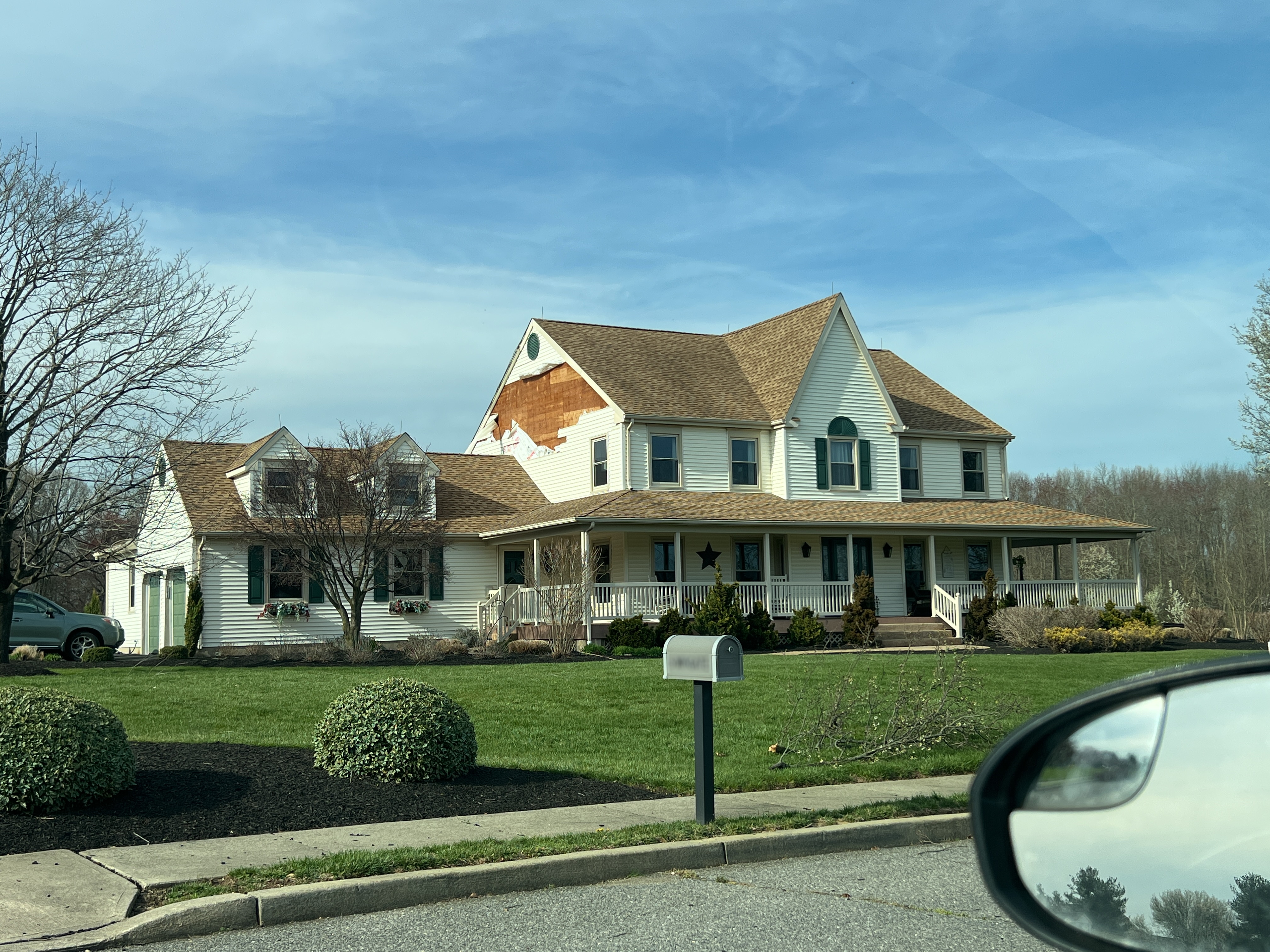
A large section of roof was peeled off of this single-family home as the tornado reached its peak intensity with maximum estimated winds of 100 mph.
Debris was lofted about 250 yards from a damaged building at the New Jersey Youth Challenge Academy as the tornado reached its peak strength with winds around 110-120 mph.
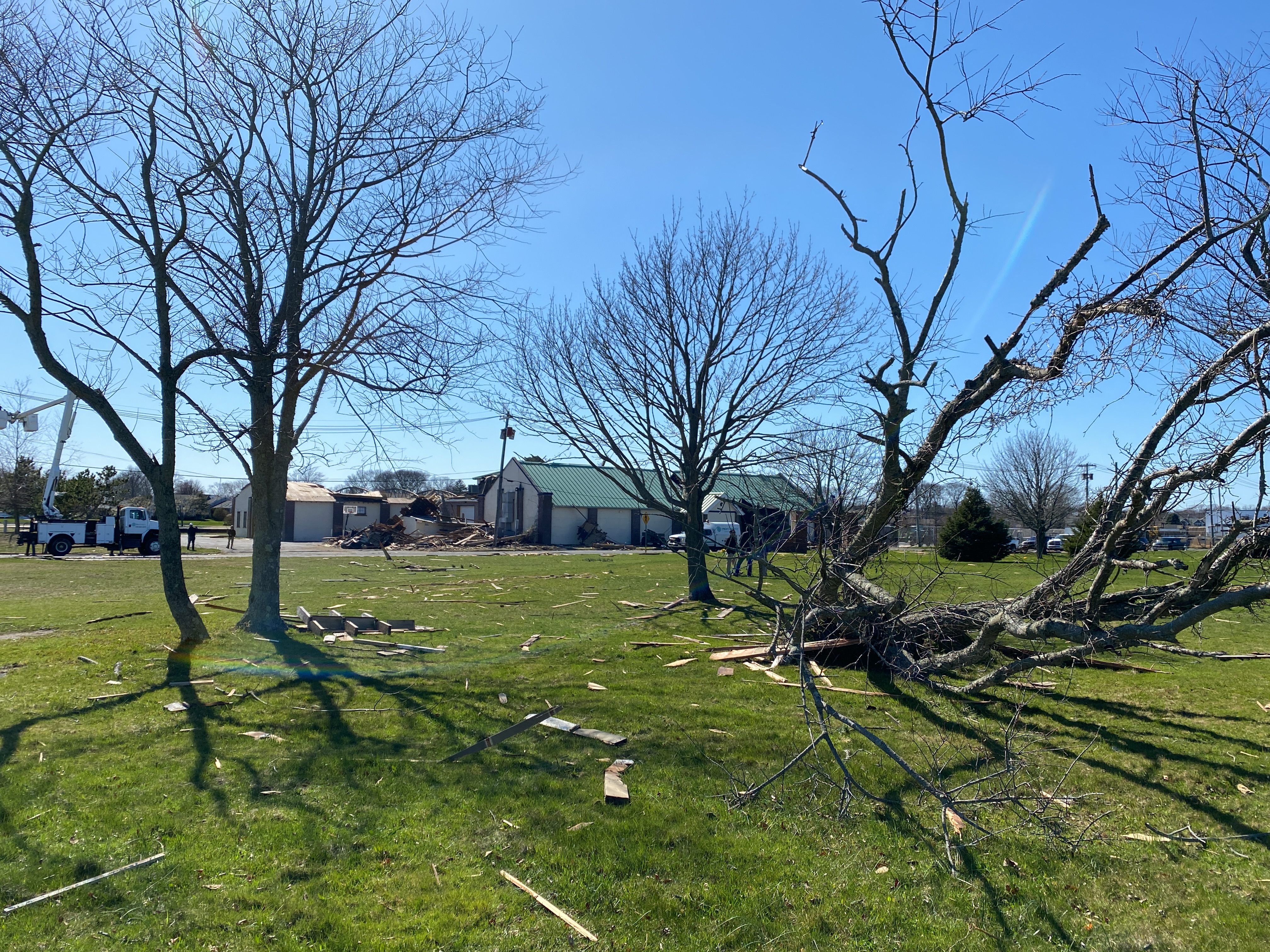
Large sections of siding was peeled off of this single-family house as the tornado reached its maximum intensity with estimated peak winds of 110 mph.
Numerous trees were uprooted and snapped across this golf course, resulting in damage consistent with 100 mph straight-line winds. |


.jpg)


 Coastal Flood
 Marine Forecasts
 Text Products
 Climate Information
 Skywarn
 Submit Storm Report
 Weather Event Archives
 Forecast Discussion
 Emergency Managers
 Briefing Page