 |
METHODOLOGY
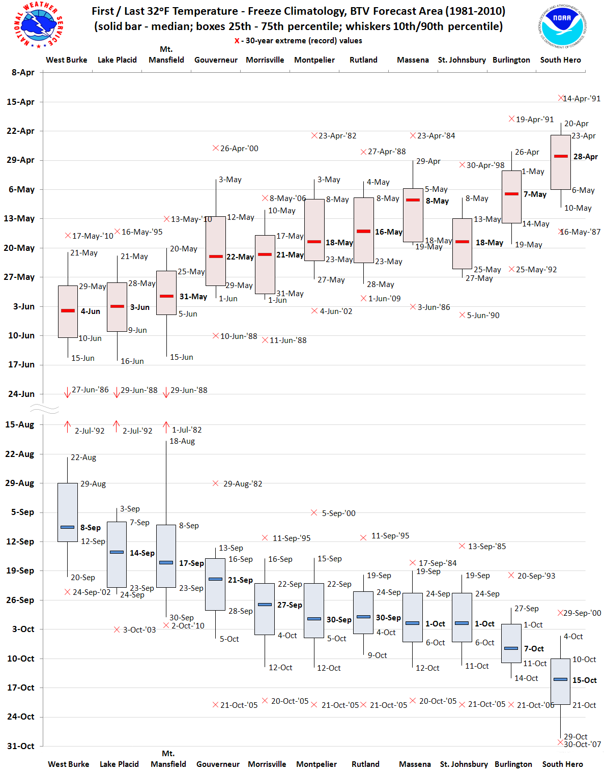
Seasonal dates of the first and last freezing temperature (at or below 32oF) over a 30-year period are analyzed using a percentile rank analysis for each surface observing site. Locations include first-order reporting stations, such as Burlington International Airport, and many long-running cooperative observing stations spread across the North Country. These freeze data are important for agricultural purposes.
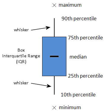
How to read the box and whisker graphs: Box and whisker diagrams are employed to view the data distribution. An example of the box and whisker diagram format is shown at left. The shaded region of each graph (i.e., "the box") shows the middle 50% of the range of first/last freeze dates. The top of the box is the 75th percentile and the bottom is the 25th percentile. The solid line within the box shows the median (or 50th percentile) first/last freeze date for that location. The lines extending upward and downward from the box (i.e., "the whiskers") reach to the 10th and 90th percentile of the data distribution. That is, only 10% of the data lies above and below the ends of the whiskers. Lastly, the "x" indicates the extreme (record) freeze dates back to 1970, or for the period of record if the station record is shorter. The intent of the box and whisker format is to give a comprehensive view of the range of first and last freeze dates at individual sites, and facilitate comparison between different locations around WFO Burlington's forecast area
(see Banacos 2011 for more info). For additional freeze climatology discussion, see text accompanying each freeze region below. |
 |
|
|
|
|
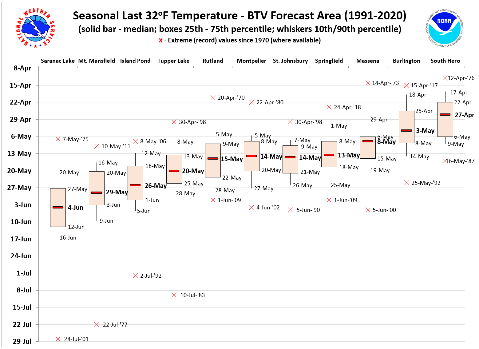
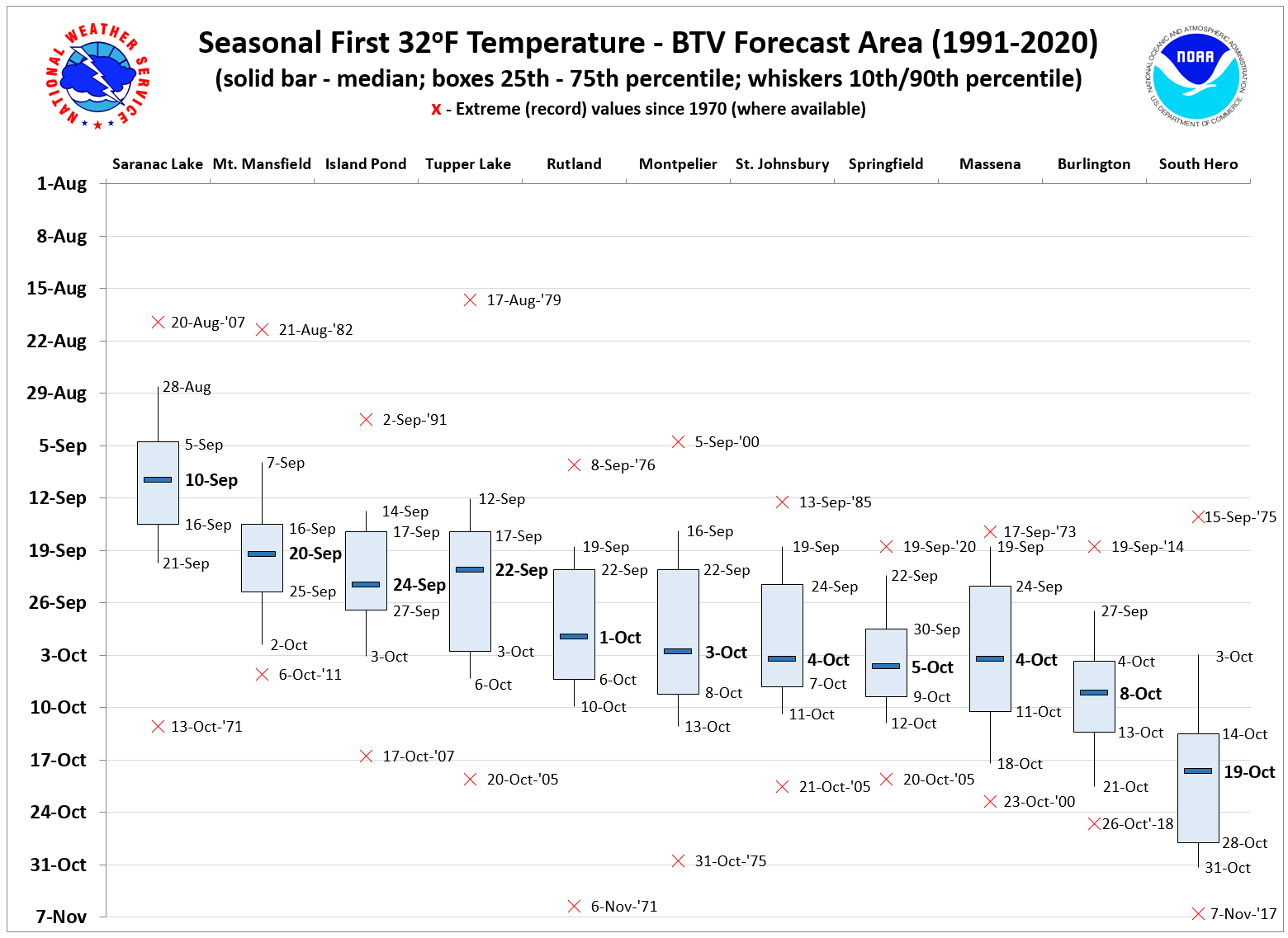
NORTH COUNTRY OVERVIEW
The varied topography of the North Country includes two major mountainous areas (the Adirondacks and Green Mountains), Lake Champlain, river basins both wide and narrow, and smaller, sheltered valleys of varying elevation. Topographic effects contribute largely to the high spatial variability in the dates of first and last freeze, evident in the box and whisker graphs.
In a typical season across the forecast area, first and last freezes occur in three stages, based on factors related to how well a site is able to radiatively cool on favorably calm, dry, and clear nights during the transition months in the spring and late summer/early fall. This is determined largely by local terrain, but other considerations such as land surface/soil type, and the potential mitigating effect of nocturnal fog - more frequent in some areas - also plays a modulating role. Freeze occurrence in the late summer/early fall typically progresses as follows: from the smaller, sheltered valleys of the Adirondacks and Northeast Vermont, across areas removed from the moderating influence of Lake Champlain, at sites very near Lake Champlain. The last freeze in spring occurs in reverse order. Despite inherent small-scale variability, some generalities can be made from the climatology, especially when divided into regions of similar topography.
|
|
|
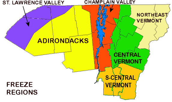
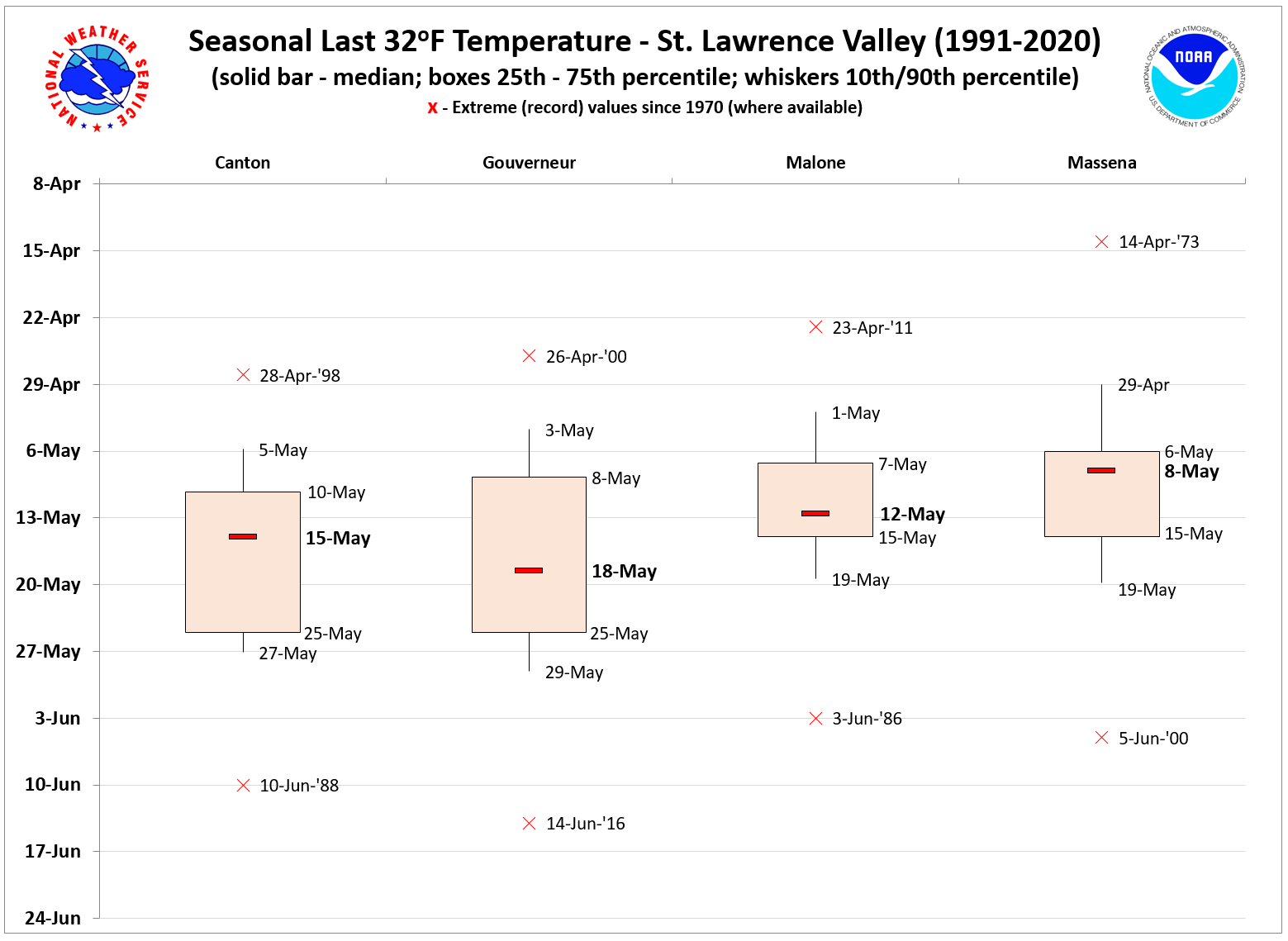
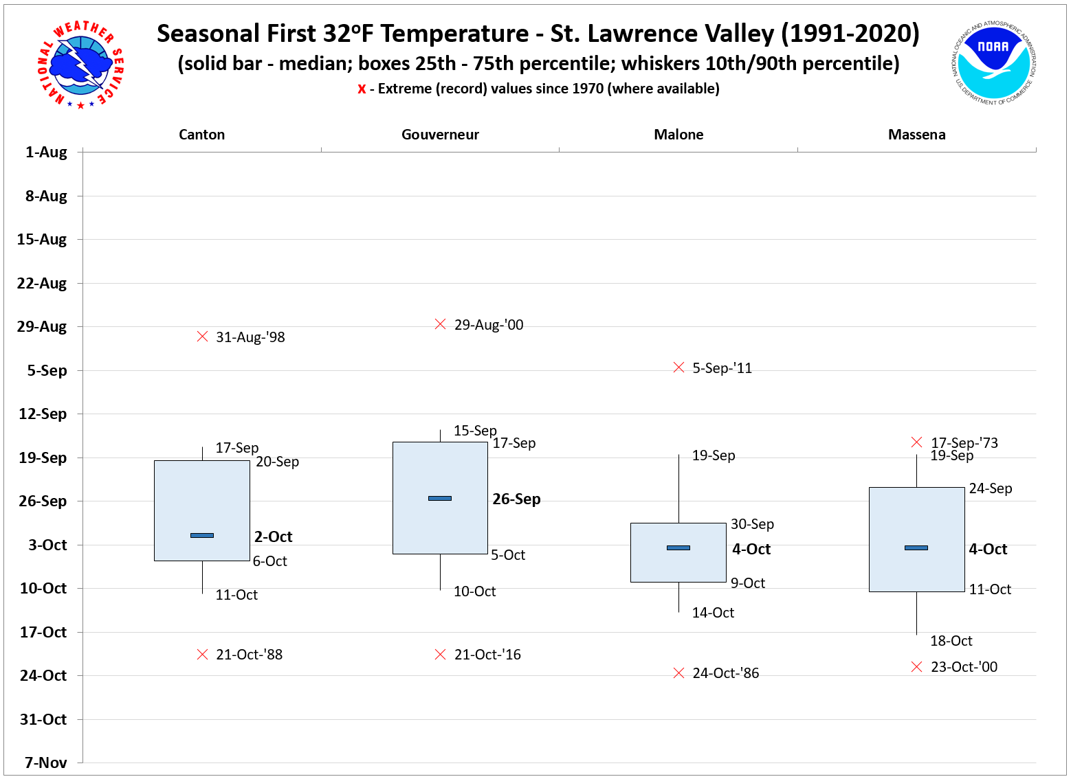
ST. LAWRENCE VALLEY
As a relatively wide and flat region (at elevations generally between 200 - 450 feet), the St. Lawrence valley tends to have higher surface winds and experiences boundary layer "decoupling" later at night than the adjacent valleys within the Adirondacks. Thus, the potential for downward turbulent mixing of warmer air through the surface/radiative inversion tends to be greater during the night, having the effect of slowing the overall rate of cooling. The climatology shows that this can be sufficient to avoid a freeze with marginal air masses that might produce freezes elsewhere in the Adirondacks or Northeast Vermont. First freeze dates generally stretch from the third week of September into the first week of October, with the earlier freezes occurring away from the immediate area of the St. Lawrence river itself (e.g., at Canton and Gouverneur). The unfavorably wet pattern of early October 2005 delayed the first freeze in this region until the night of October 20th/21st. The last freeze of spring will typically occur during early May at locations near the St. Lawrence River, but up to 2.5 weeks later at sites removed from the river and on the fringe of the Northern Adirondacks (e.g., Canton and Gouverneur). |
|
SPRING
|
FALL
|
 |
 |
|
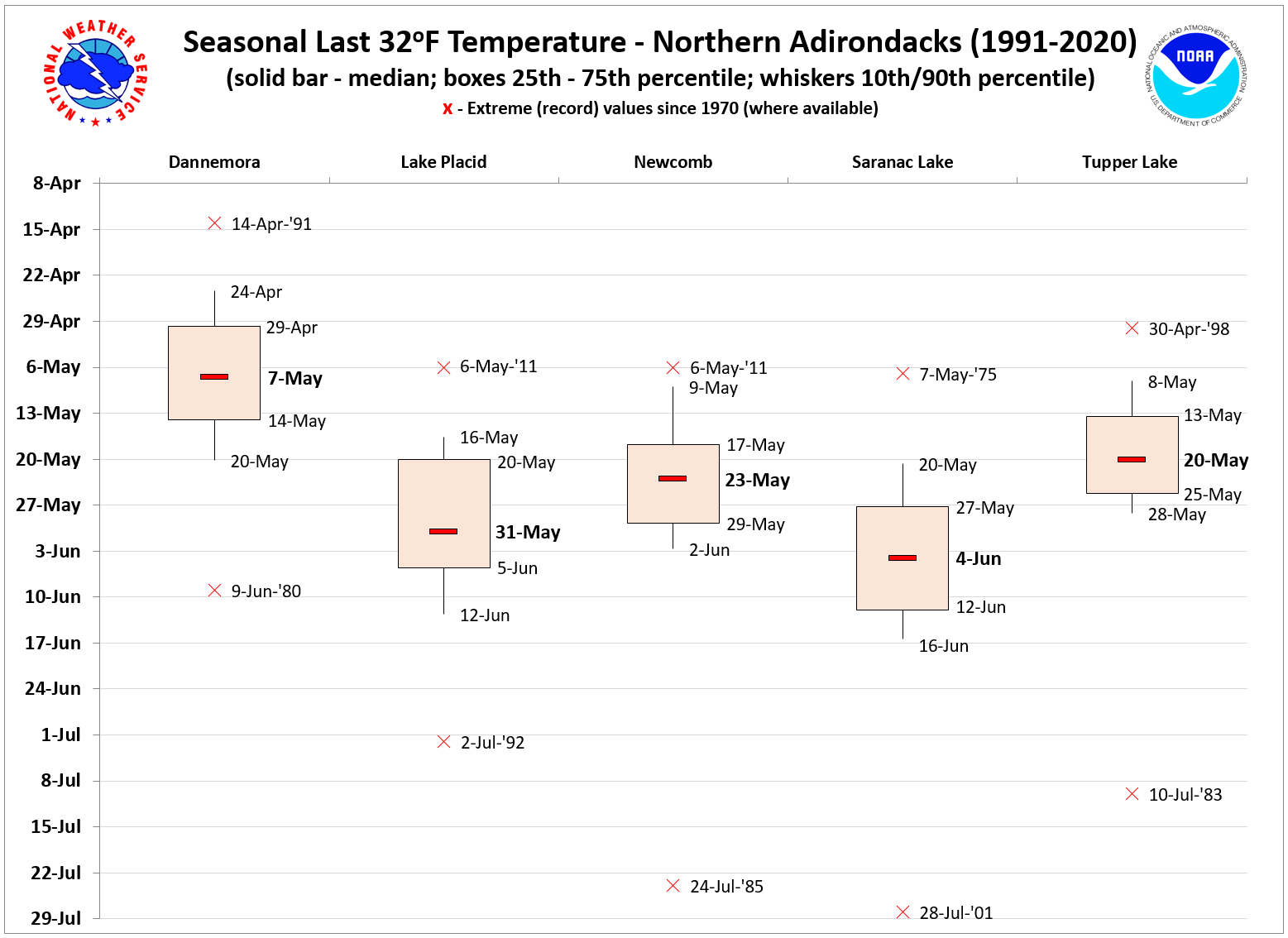
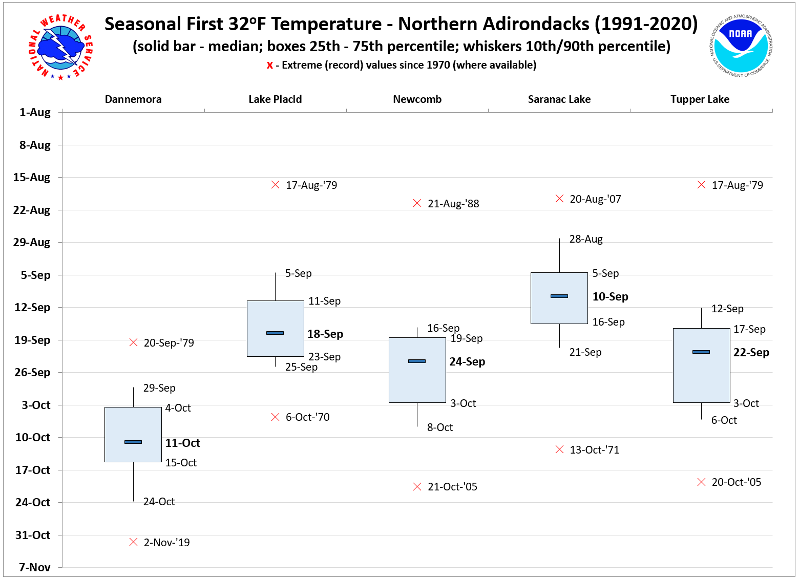
NORTHERN ADIRONDACKS
A region of complex terrain consisting of high peaks (many in excess of 4000 ft., with Mt. Marcy at 5344 ft.) and narrow, steep valleys. Valley floors in the region are of relatively high elevation, above 1000 ft. The Lake Placid cooperative observer site is at an elevation of 1940 ft. These sheltered, "elevated valley" sites tend to decouple quickly and radiate effectively at night when skies are clear. This results in relatively early first (late last) freeze dates, rivaled only by sheltered valleys of Northeast Vermont. Also, similar to Northeast Vermont, rare mid-summer freezes have been recorded during the period (e.g., 7/2/92 at Lake Placid, 7/10/83 at Tupper Lake, 7/24/85 at Newcomb, and 7/28/01 at Saranac Lake). Saranac Lake - a noted "cold spot" in the Burlington forecast area - has a median first freeze of September 10th, which is the earliest in the forecast area. In this region, the first freeze is rarely delayed into October, and last freezes can easily spread into the first half of June, especially at Lake Placid and Saranac Lake. |
|
SPRING
|
FALL
|
 |
 |
|
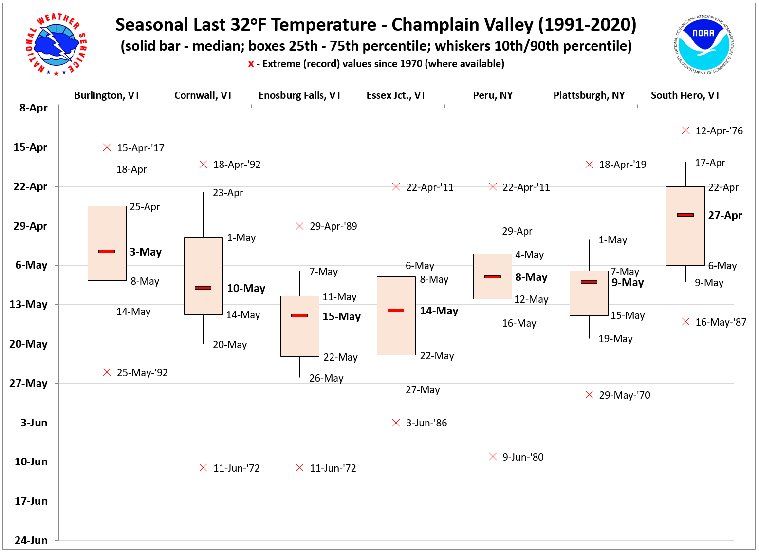
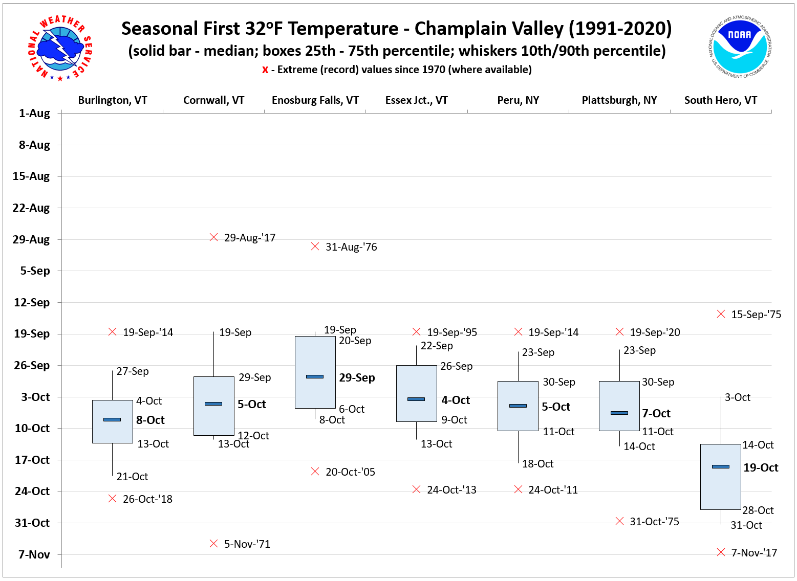
CHAMPLAIN VALLEY
This region has the longest growing season owing largely to the moderating influence of Lake Champlain. The north-south valley orientation, and steep terrain at its limits, tends to result in higher surface winds compared to smaller adjacent valleys. As a result, the boundary layer tends to decouple more slowly on clear nights. The time of median first freeze is progressively delayed at sites closer to the lake (and particularly at South Hero, situated in the Champlain Islands). The relatively warm lake in the fall also limits the strength of the nocturnal inversion, allowing for downward turbulent mixing of warmer air through the nocturnal inversion, slowing the rate of overnight cooling. This effect is also evident during the spring. However, because the lake temperatures are closer to freezing in the spring, the differences are less pronounced, with more overlap in the freeze data distribution between Burlington and South Hero for the last freeze as opposed to the first. The first freeze during the fall typically will occur during the first two weeks of October. At South Hero, the first freeze is typically in mid to late October. In the spring, the last freeze at South Hero is typical between the last week of April and the first week of May. Elsewhere, last freezes typically occur in early to mid May. |
|
SPRING
|
FALL
|
 |
 |
|
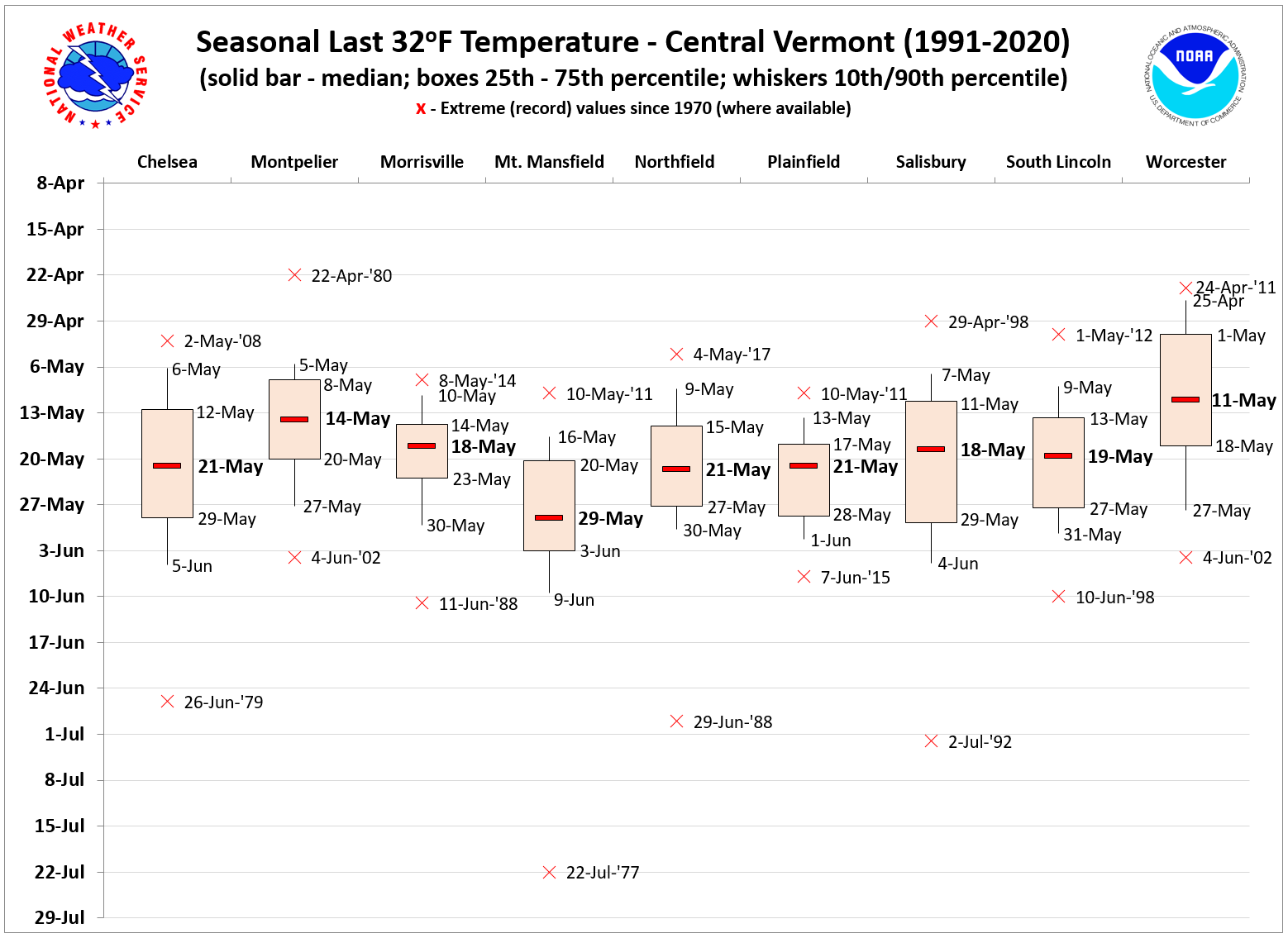
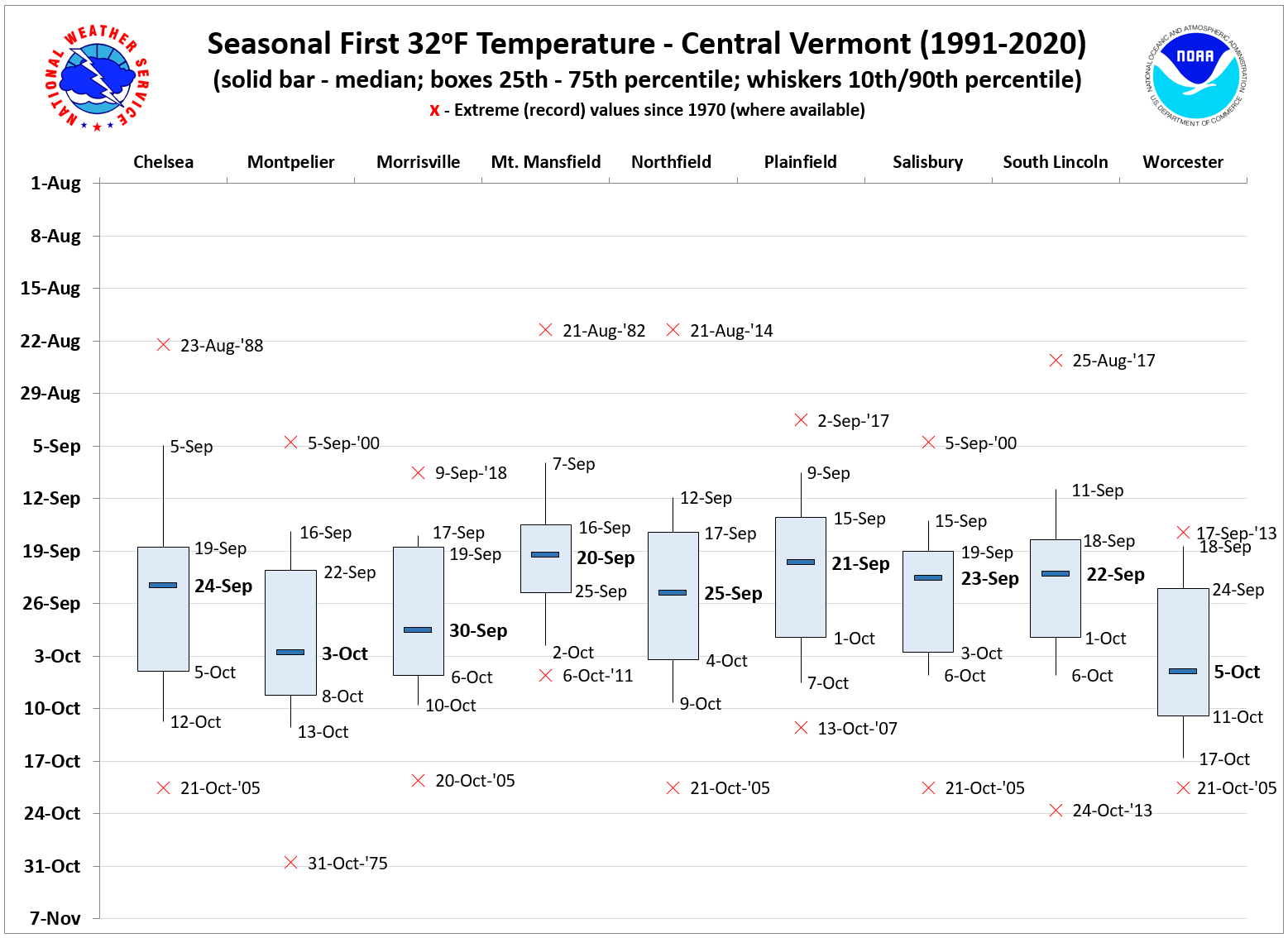
CENTRAL VERMONT
Terrain in central Vermont is highly variable, with several mountain ranges, steep river valleys, and a few sheltered valleys. Central Vermont is generally a more moderate freeze region than Northeast Vermont, with first freeze dates typically occurring in the latter half of September into the first week of October. The Mt. Mansfield observation near the summit has the most focused first freeze distribution, with 50% of occurrences between 16 - 25 September. The wet weather pattern of October 2005 delayed the first freeze until the night of October 20th/21st uniformly across this region. The last freeze of spring is typical between the second and third week of May, but can extend into early June in some years. |
|
SPRING
|
FALL
|
 |
 |
|
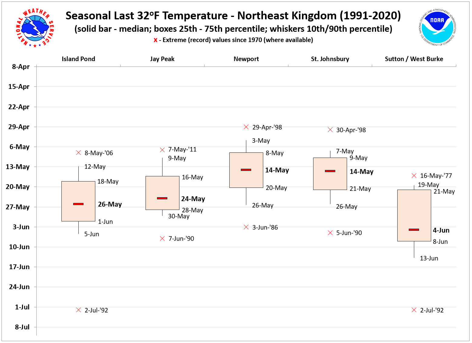
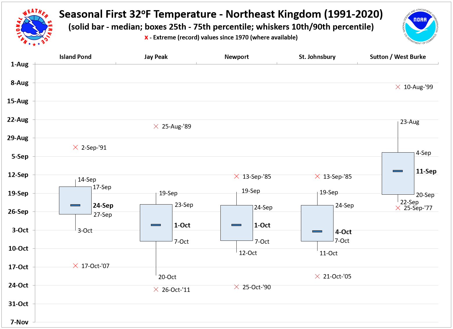
NORTHEAST VERMONT
Northeast Vermont displays high variability between stations situated in smaller, more sheltered valleys (e.g., Island Pond) as compared to larger river basins (e.g., St. Johnsbury). Sheltered locations have recorded rare freezes during the summer months, such as occurred at Island Pond and West Burke on July 2nd, 1992. The first freezes typically occur in two stages across the region. First, in the sheltered valleys in mid-September, which experience the best radiative cooling conditions (e.g., Island Pond and Sutton). Second, in the larger basins during the last week of September into the first week of October (Newport and St. Johnsbury). The propensity for nocturnal/valley fog in the larger river basins also contribute to the delayed freezes in portions of the Upper Connecticut and Passumpsic River basins, including in St. Johnsbury. The last freeze typically occurs between the second and third week of May at Newport and St. Johnsbury, but sometimes stretches into early June at Island Pond and especially Sutton / West Burke. |
|
SPRING
|
FALL
|
 |
 |
|
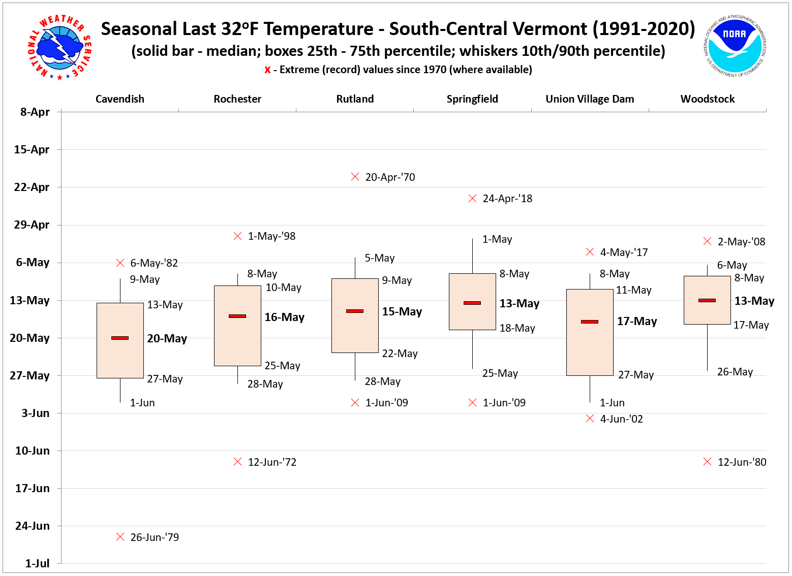
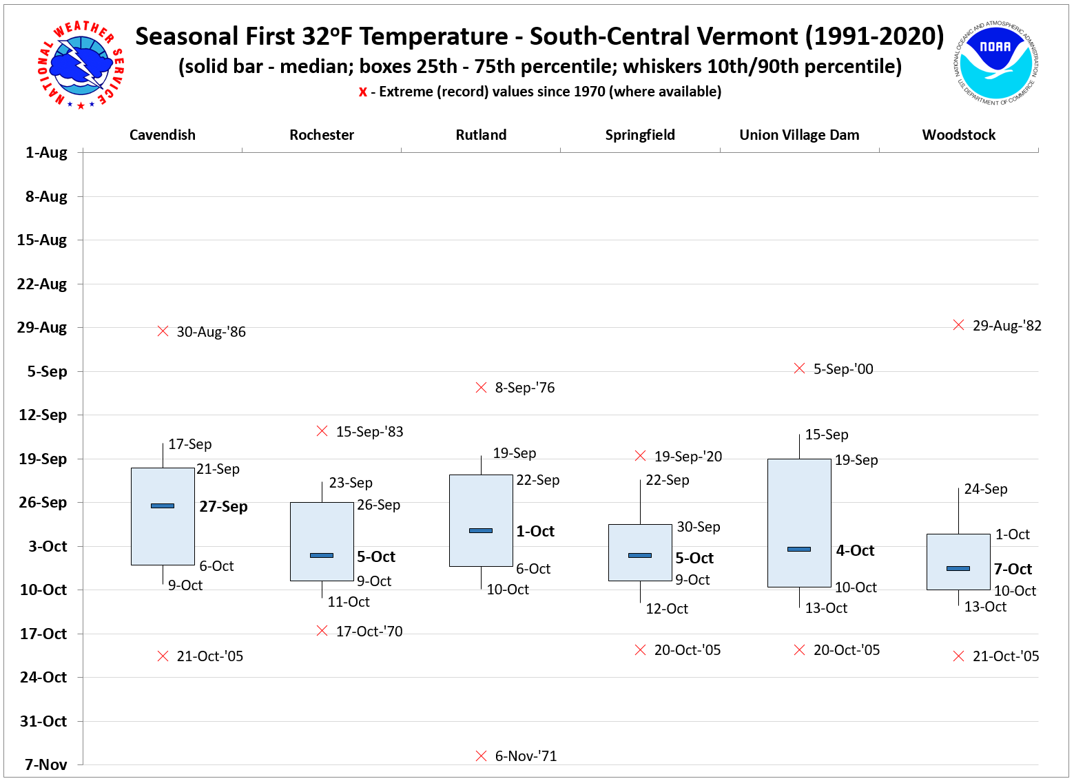
SOUTH-CENTRAL VERMONT
Despite highly varied terrain, south-central Vermont exhibits relatively uniform first and last freeze dates between stations in the region. In the spring, the last freeze typically occurs during the second or third week of May, with median last freeze dates between May 13th and May 20th for the five sites analyzed. All sites have recorded freezes beyond June 1st, but such late freeze events occur in less than 10% of years. Cavendish recorded a late June freeze on 6/26/1979. The first freeze of the fall typically occurs during the last week of September or first week of October, similar to the Central Vermont freeze region. A couple of late August freezes have occurred in the record since 1970 (8/29/1982 at Woodstock and 8/30/1986 at Cavendish). Many of the stations exhibit the same October 20-21, 2005 extreme late freeze event, which was associated with an anomalously cloudy and wet October that year. |
|
SPRING
|
FALL
|
 |
 |
|
Questions pertaining to this resource may be referred to peter.banacos@noaa.gov.
REFERENCE
Banacos, P. C., 2011: Box and whisker plots for local climate datasets: Interpretation and creation using Excel 2007/2010. NWS Eastern Region Technical Attachment No. 2011-01, National Weather Service, Eastern Region Headquarters, Bohemia, NY, 20 pp.

