National Weather Service United States Department of Commerce


Direct questions/comments to author Seth Kutikoff


Meteorological Event Overview

The 20 February 2026, winter storm was characterized by a potent synoptic-scale setup that favored a brief but intense period of heavy snowfall across northern New York and Vermont. The large-scale forcing was dynamic, bolstered by a powerful upper-level jet stream. At 12Z on February 20th, the 250-mb analysis revealed a robust 150+ kt jet streak extending from southern Arizona and New Mexico northeastward into the Ohio River Valley (Figure 1). By Friday evening, as the trough advanced, the North Country became favorably positioned within the left exit region of this intense jet streak, inducing enhanced upper-level diffluence, divergence and strong deep-layer ascent.


Figure 1. The 250-mb analysis valid at 12Z on 20 February 2026. Rawinsonde observations are plotted along with streamlines. Isotachs are shaded at 25 kt intervals starting at 75 kt.[click to enlarge]


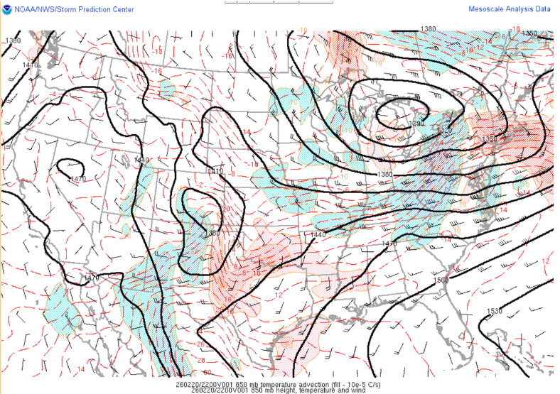
In the lower troposphere, during the daylight hours of February 20th, a closed 850mb low tracked east-northeastward across the central Great Lakes region. Extending eastward from the closed low, an 850mb warm front lifted northeastward across Pennsylvania and New York providing favorable low-level warm aid advection for synoptic ascent (Fig 2.). This provided a coupled setup featuring favorable jet dynamics in the upper troposphere juxtaposed with lower-level isentropic ascent driven by the advancing warm front. This combination generated a pronounced "front-end thump" of snowfall, supported by rich moisture transport into the Northeast. Snowfall rates during the evening commute that Friday evening reached 1 to 2 inches per hour.


Figure 2. 850 mb analysis valid at 22Z on 20 February 2026. Solid black contours denote geopotential height (meters), dashed red contours represent temperature (deg C), and wind barbs indicate wind speed and direction. Each full (half) barb represents 10 (5) knots. Color-filled regions represent 850 mb temperature advection (scaled at 10-5 C s-1), highlighting areas of strong warm air advection (red) and cold air advection (blue). Data and graphic courtesy of the NOAA/NWS/Storm Prediction Center (SPC). The SPC mesoanalysis using a RAP 1-hour forecast as its first guess field. [click to enlarge]


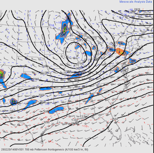
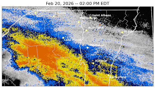
As the synoptic forcing translated over the region, the precipitation organized into a mesoscale snowband near the advancing northeast edge of the precipitation shield. This organization was directly tied to the lower-level frontal zone, as strong 850–700 mb deformation and frontogenesis translated northeastward into Vermont and northern New York. A loop of 700 mb 2-D Petterssen frontogenesis is available in Figure 3.


Figure 3. The 700mb loop of geopotential heights (meters, black solid lines), temperature (Celsius, red dashed lines), and positive frontogenesis (shaded, K 100km-1 3 hr-1) valid from 14Z through 23Z on 20 February 2026.[click to enlarge]

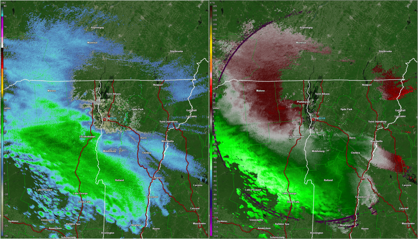
This intense frontogenesis produced a robust secondary/transverse circulation, forcing the frontal-scale banded precipitation observed during the event. Snowfall was developing in the Champlain Valley area during the mid-late afternoon hours (Fig. 4). It was this leading mesoscale snowband that contained the heaviest snowfall rates. Increasing downslope flow is evident across eastern Chittenden County between 20 and 21Z; these downslope winds resulted in a localized minimum in snowfall totals across eastern Chittenden County.


Figure 4. The Burlington, Vermont (KCXX) reflectivity (dBZ, left) and base velocity (knots, right) at 1.3 degree elevation angle from 1902Z through 2133Z on 20 February 2026. Key features include a laterally translating mesoscale reflectivity band on the leading edge of precipitation, and the development of downslope flow on the western slopes of the Green mountains (right panel), which helped limit snowfall totals in eastern Chittenden County.[click to enlarge]

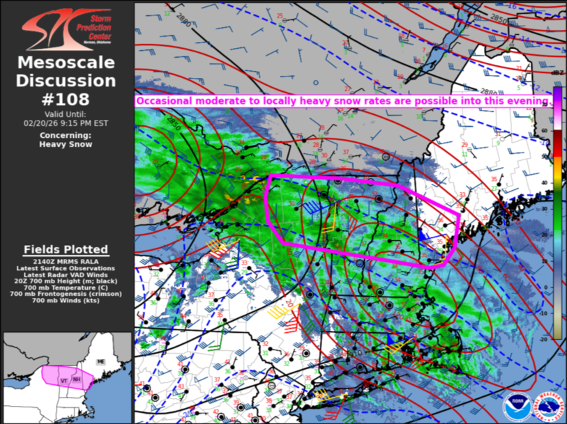
Consistent with the classification scheme established by Kenyon et al. (2020), this feature exhibited the classic structural and kinematic signatures of a laterally translating snowband (Fig. 5). The near-band environment was characterized by diffluent southwest flow, modest warm advection along the band axis, and wind profiles that veered with height.


Figure 5. Conceptual model for the laterally translating snowband, from Kenyon et al. (2020), their Figure 17a.[click to enlarge]

References:


A special thanks to Peter Banacos and Robert Haynes for reviewing and providing input.


DISCLAIMER


Radar imagery for Figure 4 was generated using GR2Analyst, Gibson Ridge Software Company http://www.grlevelx.com/gr2analyst_2/


Fast Facts/Summary


[click to enlarge]  

  • Overlap of a potent mid-level warm front and strong upward motion associated with a low pressure system spinning over northern Michigan resulted in a large area of heavy snowfall, which translated northeastward across northern New York and Vermont Friday afternoon and evening, February 20, 2026.

  • Prior to issuing a Winter Storm Watch, we highlighted the expected impacts for the Friday evening commute, including heavy snowfall rates, as seen in the graphic below:


[click to enlarge]  


  • Observed snowfall rates were up to 2 inches per hour; continuous moderate to heavy snow lasted about 4 to 6 hours in most locations before snow rapidly diminished in intensity.

  • This heavy and wet snow made for very difficult driving conditions; many cars were stuck, including on a hill on US-2 in Colchester, and other traffic incidents were reported in towns such as Shoreham and Worcester in Vermont and Port Henry and Keene in New York.


Snowfall Accumulations

Public Information Statement
National Weather Service Burlington VT
1131 AM EST Sat Feb 21 2026

...SNOWFALL REPORTS...

Location                     Amount    Time/Date       Provider             

...New York...

...Clinton County...
Saranac                      9.3 in    0630 AM 02/21   Public               
1 E Schuyler Falls           8.8 in    1210 AM 02/21   Trained Spotter      
2 WNW Cadyville              8.7 in    0335 AM 02/21   Mesonet              
Peru                         8.5 in    1230 AM 02/21   Public               
Altona                       8.5 in    0730 AM 02/21   Public               
Plattsburgh                  8.5 in    0917 AM 02/21   Public               
Morrisonville                8.1 in    0911 AM 02/21   Public               
3 NW Point Au Roche          7.5 in    0700 AM 02/21   Public               
Ellenburg                    6.3 in    0335 AM 02/21   Mesonet              
West Chazy                   6.0 in    0415 AM 02/21   Public               
1 WNW Chazy                  5.5 in    0335 AM 02/21   Mesonet              

...Essex County...
Lake Placid                  11.0 in   0815 AM 02/21   COOP                 
Keene Valley 2.5 NE          10.3 in   0630 AM 02/21   COCORAHS             
Olmstedville 4.6 NNE         9.5 in    0756 AM 02/21   COCORAHS             
2 W Wilmington               9.4 in    0335 AM 02/21   Mesonet              
Bloomingdale 0.2 NW          9.3 in    0743 AM 02/21   COCORAHS             
Moriah                       8.5 in    0900 AM 02/21   Public               
4 NNE North Hudson           8.3 in    0335 AM 02/21   Mesonet              
1 SW Port Henry              8.0 in    0845 AM 02/21   Public               
3 W Newcomb                  7.9 in    0335 AM 02/21   Mesonet              
Newcomb                      7.8 in    0800 AM 02/21   Public               
Ticonderoga                  7.8 in    0800 AM 02/21   Public               
1 WNW Essex                  7.5 in    0335 AM 02/21   Mesonet              
1 W North Elba               7.5 in    0335 AM 02/21   Mesonet              

...Franklin County...
Saranac Lake 6.2 N           9.9 in    0745 AM 02/21   COCORAHS             
1 S Gabriels                 9.4 in    0335 AM 02/21   Mesonet              
1 E Tupper Lake              8.3 in    0335 AM 02/21   Mesonet              
Burke                        6.0 in    0745 AM 02/21   Public               
0.9 W Malone                 5.0 in    0700 AM 02/21   COOP                 

...St. Lawrence County...
Massena                      5.5 in    1013 AM 02/21   Trained Spotter      
1 SE Potsdam                 4.7 in    0335 AM 02/21   Mesonet              
Heuvelton 0.3 WNW            4.5 in    0810 AM 02/21   COCORAHS             
1 WSW Edwardsville           4.3 in    0335 AM 02/21   Mesonet              
3 SW Louisville              2.8 in    0335 AM 02/21   Mesonet              
Colton                       2.0 in    0745 AM 02/21   Public               

...Vermont...

...Addison County...
Shoreham                     8.0 in    0845 AM 02/21   Public               
Shoreham 3.5 NNE             7.8 in    0800 AM 02/21   COCORAHS             
Vergennes                    7.7 in    0400 AM 02/21   COOP                 
Orwell 1.2 WNW               7.3 in    0700 AM 02/21   COCORAHS             
Shoreham 0.3 SW              7.2 in    0730 AM 02/21   COCORAHS             
1 S Mt. Philo State Park     7.0 in    0630 AM 02/21   Public               
Weybridge                    7.0 in    0700 AM 02/21   Public               
Panton                       7.0 in    0730 AM 02/21   Public               
Bristol                      6.0 in    0645 AM 02/21   COOP                 
Starksboro 4.4 ENE           5.0 in    0900 AM 02/21   COCORAHS             

...Caledonia County...
1 W Walden                   8.0 in    0810 AM 02/21   Trained Spotter      
1 NW Ricker State Park       7.0 in    0945 AM 02/21   Public               
2 SSE East Burke             5.5 in    0700 AM 02/21   Public               
Wells River 2.1 WNW          5.4 in    0655 AM 02/21   COCORAHS             
St. Johnsbury 0.4 N          5.0 in    0700 AM 02/21   COCORAHS             
Barnet 3.5 W                 5.0 in    0745 AM 02/21   COCORAHS             
Lyndonville 1.1 W            4.7 in    0720 AM 02/21   COCORAHS             
West Burke                   4.5 in    0700 AM 02/21   Public               
Lyndonville                  4.0 in    0530 AM 02/21   Public               

...Chittenden County...
2 NNE Shelburne              8.7 in    0900 AM 02/21   Public               
South Burlington 2.6 SSW     7.9 in    0725 AM 02/21   COCORAHS             
Burlington 3.8 NW            7.5 in    0800 AM 02/21   COCORAHS             
Burlington                   7.0 in    0600 AM 02/21   Public               
Shelburne 0.5 ENE            7.0 in    0700 AM 02/21   COCORAHS             
2 N Milton                   6.8 in    0830 AM 02/21   Public               
Charlotte 2.9 NE             6.7 in    0800 AM 02/21   COCORAHS             
New North End                6.5 in    0615 AM 02/21   NWS Employee         
2 WSW Milton                 6.5 in    0817 AM 02/21   NWS Employee         
Colchester                   6.4 in    0700 AM 02/21   NWS Employee         
1 ENE South Burlington       6.0 in    0650 AM 02/21   Official NWS Obs     
Underhill 4.4 NNE            6.0 in    0700 AM 02/21   COCORAHS             
Williston 0.2 WSW            6.0 in    0700 AM 02/21   COCORAHS             
1 WSW Colchester             6.0 in    0700 AM 02/21   NWS Employee         
2 NW Westford                6.0 in    0900 AM 02/21   NWS Employee         
2 E Underhill Center         5.8 in    0630 AM 02/21   Public               
Hinesburg 1.5 SW             5.8 in    0700 AM 02/21   COCORAHS             
Underhill 5.1 NNE            5.8 in    0700 AM 02/21   COCORAHS             
Williston 3.2 SSW            5.6 in    0800 AM 02/21   COCORAHS             
Huntington 6.5 S             5.5 in    0800 AM 02/21   COCORAHS             
Hinesburg 0.9 N              5.5 in    0845 AM 02/21   COCORAHS             
1 S Essex Center             5.4 in    0630 AM 02/21   NWS Employee         
Williston 2.9 NW             5.0 in    0700 AM 02/21   COCORAHS             
Nashville 1 E                4.4 in    0645 AM 02/21   COOP                 
1 ESE Jericho                4.3 in    0900 AM 02/21   Public               

...Essex County...
Lunenburg 2.3 NNW            6.0 in    0530 AM 02/21   COCORAHS             
Island Pond                  6.0 in    1011 AM 02/21   COOP                 

...Franklin County...
Fairfax 4.9 WNW              6.6 in    0900 AM 02/21   COCORAHS             
1 ESE Saint Albans           6.5 in    0800 AM 02/21   Trained Spotter      
Saint Albans Bay State Park  6.0 in    0700 AM 02/21   Public               
2 E Fairfax                  5.8 in    0809 AM 02/21   Public               
Swanton 0.5 NNE              5.5 in    0700 AM 02/21   COCORAHS             
Swanton                      5.3 in    0839 AM 02/21   NWS Employee         
Enosburg Falls 2.5 N         5.1 in    0730 AM 02/21   COCORAHS             
Enosburg Falls               5.0 in    0741 AM 02/21   COOP                 
Montgomery 4.1 ESE           4.0 in    0700 AM 02/21   COCORAHS             

...Grand Isle County...
Grand Isle                   8.0 in    0710 AM 02/21   Public               

...Lamoille County...
Morrisville                  8.2 in    0630 AM 02/21   Public               
1 SSE Smugglers Notch        7.5 in    0720 AM 02/21   Public               
Stowe 0.2 SW                 7.2 in    0730 AM 02/21   COCORAHS             
1 WSW Morrisville            7.0 in    0720 AM 02/21   Public               
2 E North Hyde Park          7.0 in    1032 AM 02/21   Public               
Johnson 2 N                  6.5 in    0700 AM 02/21   COOP                 
Jeffersonville 1.3 SSW       5.9 in    0700 AM 02/21   COCORAHS             
Cambridge                    5.3 in    0748 AM 02/21   Public               

...Orange County...
Tunbridge                    8.5 in    0700 AM 02/21   Public               
Braintree 2.8 SW             8.2 in    0700 AM 02/21   COCORAHS             
1.5 E Corinth Corners        7.8 in    0700 AM 02/21   COOP                 
Williamstown                 7.5 in    0900 AM 02/21   Public               
Williamstown 3.0 WSW         7.4 in    0700 AM 02/21   COCORAHS             
Bradford 2.2 NNW             7.3 in    0600 AM 02/21   COCORAHS             
West Fairlee 1.8 ENE         6.3 in    0830 AM 02/21   COCORAHS             

...Orleans County...
Morgan 6.7 SE                6.0 in    0800 AM 02/21   COCORAHS             
Newport Center               6.0 in    1030 AM 02/21   Public               
Greensboro 3.9 NNE           5.6 in    0620 AM 02/21   COCORAHS             
Westfield 0.8 WNW            5.0 in    0700 AM 02/21   COCORAHS             
Albany                       4.8 in    0845 AM 02/21   Public               
Greensboro 2.1 NNW           4.6 in    0700 AM 02/21   COCORAHS             
Derby Line 1.9 W             4.6 in    0700 AM 02/21   COCORAHS             
Brownington 4.7 ESE          4.2 in    0800 AM 02/21   COCORAHS             
Newport                      4.0 in    0909 AM 02/21   Public               

...Rutland County...
Pittsford 2.2 SSE            8.5 in    0800 AM 02/21   COCORAHS             
Rutland 1.2 N                8.0 in    0700 AM 02/21   COCORAHS             
1 N Rutland                  8.0 in    0700 AM 02/21   COOP                 
Shrewsbury 0.8 W             6.5 in    0545 AM 02/21   COCORAHS             
Chittenden                   6.5 in    0747 AM 02/21   Public               
West Rutland                 6.5 in    0825 AM 02/21   Public               
West Rutland 1.2 N           5.3 in    0615 AM 02/21   COCORAHS             
Wallingford 2.7 SSW          4.6 in    0700 AM 02/21   COCORAHS             

...Washington County...
Warren 2.8 E                 12.0 in   0700 AM 02/21   COCORAHS             
Waterbury 3.0 NW             9.5 in    0600 AM 02/21   COCORAHS             
Montpelier 1.7 NE            8.1 in    0700 AM 02/21   COCORAHS             
Northfield 1.5 N             8.0 in    0700 AM 02/21   COCORAHS             
3 SSW Woodbury               8.0 in    0815 AM 02/21   Public               
Waitsfield                   8.0 in    0900 AM 02/21   Public               
East Montpelier              7.6 in    0730 AM 02/21   COCORAHS             
Berlin 4.3 WNW               7.4 in    0645 AM 02/21   COCORAHS             
Moretown 2.1 N               7.2 in    0800 AM 02/21   COCORAHS             
Woodbury 1.3 NNW             7.1 in    0800 AM 02/21   COCORAHS             
4 ESE Marshfield             7.0 in    1040 AM 02/21   Trained Spotter      
Woodbury 3.4 NNW             6.5 in    0700 AM 02/21   COCORAHS             
Cabot 3.9 ENE                6.5 in    0900 AM 02/21   COCORAHS             
2 ENE Cabot                  6.4 in    1050 AM 02/21   Public               
Plainfield 1 ESE             6.2 in    0700 AM 02/21   COOP                 

...Windsor County...
Quechee                      9.8 in    1045 AM 02/21   Public               
1 N Quechee                  9.3 in    0100 AM 02/21   Public               
4 NE West Hartford           8.9 in    0754 AM 02/21   Public               
2 N West Windsor             8.0 in    0630 AM 02/21   Trained Spotter      
South Pomfret                7.5 in    1128 PM 02/20   Public               
South Royalton               7.5 in    0630 AM 02/21   Public               
Barnard 2.7 NW               7.5 in    0700 AM 02/21   COCORAHS             
Rochester 1.7 NNE            7.0 in    0500 AM 02/21   COCORAHS             
Ludlow 3.4 S                 7.0 in    0700 AM 02/21   COCORAHS             
0.6 E Woodstock              7.0 in    0800 AM 02/21   COOP                 
3 S Ludlow                   7.0 in    0821 AM 02/21   Trained Spotter      
Proctorsville 0.3 NNE        6.8 in    0700 AM 02/21   COCORAHS             
1 ESE Weston                 6.5 in    0700 AM 02/21   COCORAHS             
Andover 2.5 NW               6.5 in    0700 AM 02/21   COCORAHS             
Chester 3.0 WSW              6.2 in    0700 AM 02/21   COCORAHS             
Chester 4.1 WNW              6.0 in    0800 AM 02/21   COCORAHS             


Mesoscale Meteorology


Intervals of sleet and freezing rain took place in the St. Lawrence Valley between about 1 PM and 5 PM. Above is the 20 February 2026 at 12Z HREF output for MSS (Massena, NY) at 4 PM, which shows the plumes of model forecast temperature, with only one depicting a narrow warm nose off the surface. Freezing rain observed at Massena around 4 PM was not in the model consensus.[click to enlarge]


Simulated sounding at BTV as heavy snow was falling at 7 PM. Inferred warm air advection is occurring in the DGZ (roughly 3 to 4 kilometers above ground level), and intense precipitation is supported by strong upward motion in this layer and extending downward in a deep moist layer to near the surface.[click to enlarge]


The second of two SPC mesoscale discussions during this event in the NWS Burlington County Warning Area. Strongly veering winds are plotted (red, yellow, and blue wind barbs) at the CXX radar as heavy snow was ongoing. Surface observations show temperatures at 5 PM in the upper 20s to mid 30s. [click to enlarge]


Regional radar loop showing heavy snow bands (yellows and orange colors) moving northward through the region from 2 PM to midnight. Bands become briefly stationary but generally translate northeastward and diminish in intensity generally after 9 PM. Aside from the beam blockage evident in eastern Caledonia County and Essex County in Vermont, the reflectivity is a good proxy for how the snowstorm unfolded spatially.[click to enlarge]


A graph of accumulated precipitation as measured by the ASOS rain gauge at the BTV airport also shows observed visibility based on METARs. Heavy snow during the first 17 minutes of the hour occurred in which 0.08” of liquid equivalent was measured. A second burst of ¼ SM heavy snow began 40 past the hour with this one lasting 10 minutes. Altogether, 0.17” was measured between 7 and 8 PM; concurrently, snowfall of 2.0 inches was measured by the FAA Contract Weather Observer, supporting a snow to liquid ratio of just under 12:1.[click to enlarge]


NBM Verification


This data corresponds with the latest run of the operational National Blend of Models available at the time of Winter Storm Watch issuance. 8” probabilities suggested the highest likelihood of reaching Winter Storm Warning (WSW) criteria in Essex County, New York, and Addison and Windsor counties in Vermont. The 6” probability greater than 60% would have served as a good WSW issuance threshold for this event. Largely widespread 4”+ observations match well with the probabilistic data showing high probabilities of Winter Weather Advisory criteria being exceeded areawide.[click to enlarge]


This graph is a box and whisker of the snowfall probability, and the final forecast values in the blue square. The range of potential outcomes were spread between 2-4” on the low end, and about 7-10” on the high end. This spans the range of being below criteria for any winter headline and winter storm warnings, and it offers insight into uncertainty in the forecast.[click to enlarge]


Comparing the final NWS forecast with the 50th percentile, we added value across the Champlain Valley through much of central Vermont.[click to enlarge]


Videos and Links


Large aggregates produced very low visibilities between ½ and ¼ miles. Credit: Tommy Horn[click to enlarge]
Original X Post


Wet snow caked to tree limbs, but the weight of snow was not so heavy to cause significant impacts. Credit: Christina Fulton[click to enlarge]
Original Facebook Post