Dangerous heat will expand from the Gulf Coast into the Southern Plains and Desert Southwest through week's end. Additional extreme heat impacting the Pacific Northwest will shift to the northern Plains by the weekend. Tropical Storm Bertha is expected to continue to impact portions of the northwestern Gulf Coast from south central Louisiana to the upper Texas coast today. Read More >
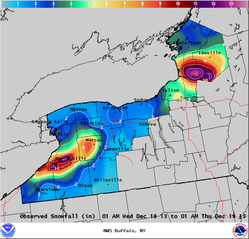
Lake Effect Summary - December 18-19, 2013
|
|
|
Maximum Snowfall: Lake Erie 12" (West Falls); Lake Ontario 11.2" (Highmarket) Duration: 24 hours +/-
Prime feature: Hybrid synoptic and lake effect.
The fourth lake effect event of the season was a combination of light synoptic snows, followed by some lake effect snows. A shortwave rode through a long wave trough over the eastern United States, and this shortwave brought several inches of snow across Western and North Central New York. Behind this shortwave, temperatures at 850 hpa dropped down to about -12C, which created enough instability over a cold, but not frozen lake surface to generate lake effect snow. Snow fell through the morning and afternoon hours off Lake Erie, before migrating northward through the evening hours and dissipated under weakening lake effect snow parameters and warm air advection. The lake effect band of snow off Lake Ontario intensified through the late morning and afternoon hours while impacting the Tug Hill region. This band too also shifted northward overnight and weakened.
|