Dangerous heat will expand from the Gulf Coast into the Southern Plains and Desert Southwest through week's end. Additional extreme heat impacting the Pacific Northwest will shift to the northern Plains by the weekend. Tropical Storm Bertha is expected to continue to impact portions of the northern Gulf Coast from the western Florida Panhandle to southeastern Louisiana through tonight. Read More >
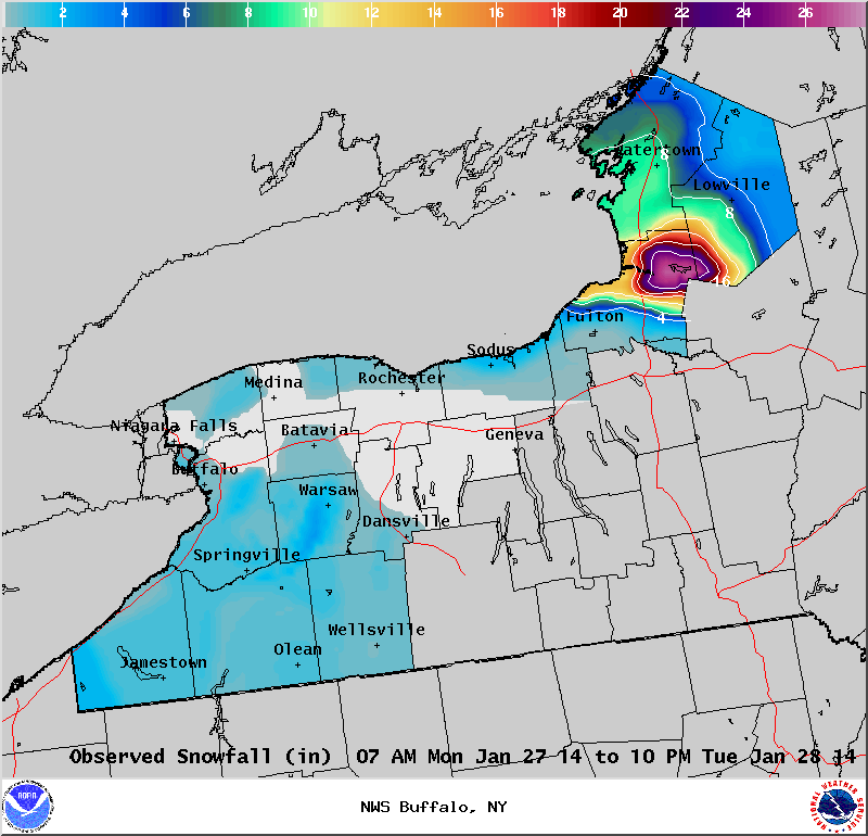
Lake Effect Summary - January 27-28, 2014
|
|
|
Maximum Snowfall: Lake Erie 2.5" (Warsaw); Lake Ontario 26" (Osceola) Duration: 36 hours +/-
Prime feature: Snow primarily Lake Ontario, very little Lake Erie Our 8th event of the long winter season began what will end up as four Lake Effect events that primarily targeted the eastern Lake Ontario region. Ice coverage on Lake Erie, and the presence of ice on upstream Great Lakes greatly limited the influence from Lake Erie. On Monday morning, January 27th, a cold front swept across the Eastern Great Lakes region and gave a burst of synoptic snow of just several inches, happening during the morning rush hour. This snarled traffic on local byways. Behind this front, a deep pool of cold air aloft, with temperatures at 850 hPa dropping to -26 to -28C, poured over the eastern Great Lakes. This set the stage for our lake effect snow event. By late January, Lake Erie was largely ice covered which greatly limited the amount of snow generated across Western New York. Narrow bands of snow did streak across Western New York, and most areas received two inches or less of snow through the event. A portion of northeast Lake Ontario was ice covered by this time as well, but much of the Lake was open which allowed an intense band of snow to form. Just a few hours after the cold front passed through the region, a band of lake effect snow formed, just south of Watertown and fanned out across northern Lewis County. As the winds aligned more westerly, this band of snow consolidated into a narrower band as it began to slowly drop southward. Snowfall rates of 1 to 2 inches per hour, combined with winds gusting to 30 to 40 mph created poor visibilities through the afternoon hours east of Lake Ontario. By late afternoon this band of snow had settled across northern Oswego County and southern Lewis and northern Oneida Counties. Lake induced equilibrium levels rose to just over 10,000 feet and with the extreme instability, lake effect snow continued into the overnight hours. A shortwave crossing over Lake Ontario lifted the band of snow a little in the evening hours, such that it focused again towards the Tug Hill region, which endured the brunt of the lake effect event. This snow band remained stationary over the Tug Hill region through much of the night. In addition to the lake effect snow, bitterly cold wind chills brought wind chills down into the negative teens through the night and morning hours Tuesday. During the day Tuesday, winds backed a little on the periphery of a surface high pressure edging northeastward from the northern Plains and Ohio Valley region. These backing winds lifted the lake effect snow band north from the Tug Hill Tuesday morning to far northern Jefferson County by noon. The increasing wind shear and southwest flow began to weaken the band such that snow fall rates diminished from their early Tuesday morning 2-3 inches per hour rate. Lake effect snow continued across northern Jefferson County through the afternoon and evening hours, though in a weakened state as a multiple banded structure occurred. With wind shear not allowing the multi banded lake snows to again form a single band, the weakened lake bands settled southward through the late overnight and daytime hours Wednesday with only a few additional inches of snow falling across Jefferson and Lewis counties.
|