Dangerous heat will expand from the Gulf Coast into the Southern Plains and Desert Southwest through week's end. Additional extreme heat impacting the Pacific Northwest will shift to the northern Plains by the weekend. Tropical Storm Bertha is expected to continue to impact portions of the northern Gulf Coast from the western Florida Panhandle to southeastern Louisiana through tonight. Read More >
Lake Effect Summary - February 9-11, 2014
|
|
|
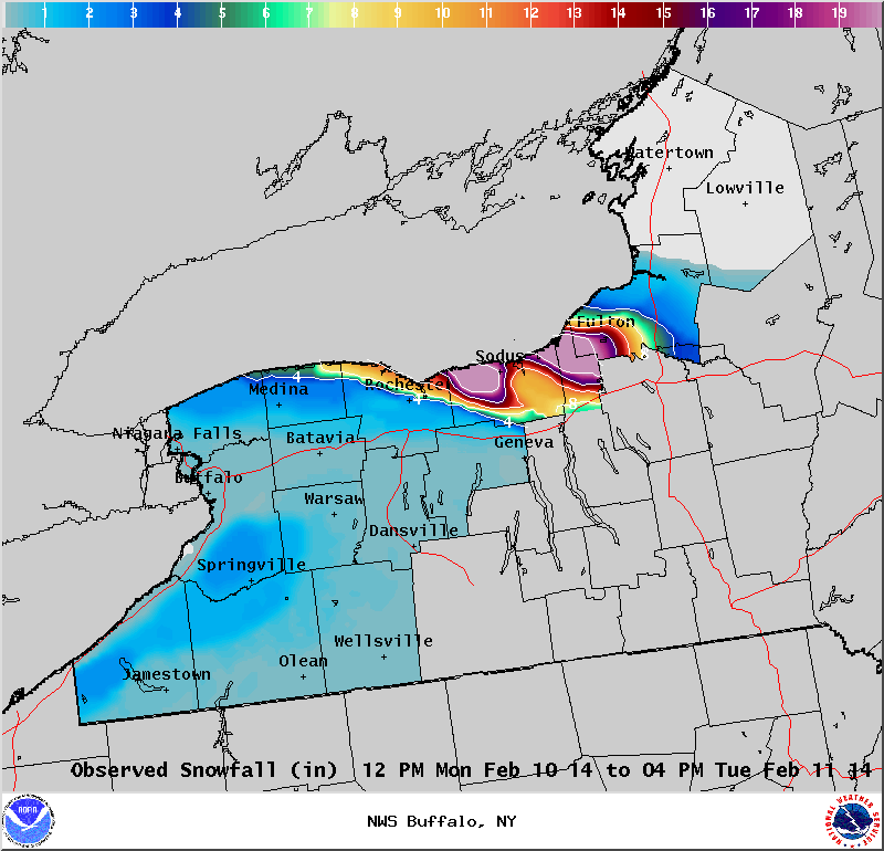
Maximum Snowfall: Lake Erie 2.1" (Ripley); Lake Ontario 30" (Martville) Duration: 48 hours +/- Prime feature: West-northwest flow event; very local heavy amounts. Our 12th lake effect event of the season started during the evening hours of February 9th and continued through the early evening of the 11th with varying intensity. The airmass was cold again, with surface temperatures in the teens to low 20s during the day and single numbers at night in lake effect areas, with 850mb temperatures bottoming out near -20C. Unlike the numerous west to southwest flow lake effect snow events this season, this event was characterized by west-northwest flow through the entire period. Multiple bands of lake effect snow were observed along much of the south shore of Lake Ontario during this event, with one or two becoming dominant at times and producing locally heavy snow. On the evening of the 9th, multiple bands of moderate to heavy lake effect snow developed first over the west end of Lake Ontario over Niagara and Orleans counties. Lake effect snow quickly filled in overnight farther east along the entire south shore of the lake. During the wee hours of the 10th, one snow band became more dominant from the northeast suburbs of Rochester into portions of western Wayne County, dropping locally heavy snow. This band slowly lifted northeast across Wayne County through early afternoon and became disorganized due to daytime heating from the higher February sun angle. The band of lake effect snow then reorganized during the early evening of the 10th over far western Oswego County, northern Cayuga County, and the northeast corner of Wayne County, where it dumped heavy snow overnight with 2 to 3 inches per hour of very fluffy, low density snow. Multiple bands of lake effect snow also filled back in along much of the south shore of the lake overnight. One of these became more dominant again from the northeast suburbs of Rochester to western Wayne County with locally heavier snow. These bands of snow remained in place during the morning of the 11th, before the higher February sun angle once again took its toll and forced the lake effect bands to break up into disorganized snow showers during the afternoon. The disorganized snow showers continued through early evening before dissipating overnight as high pressure built directly over the lower Great Lakes. The heaviest snow totals from this event were very localized, which is typical for this wind direction. The maximum amounts of 2 to 2.5 feet fell in a small area from Fair Haven to Martville and Blind Sodus Bay. A secondary area of 1 to 1.5 feet fell from near Webster to Ontario and Williamson. Elsewhere along the south shore of Lake Ontario amounts of 3 to 8 inches were common near the lake. Lake Erie was completely ice covered and produced little in the way of snowfall. The 1 to 2 inch amounts observed across the higher terrain well south of Buffalo were likely due to upslope flow and moisture from the Upper Great Lakes.
|