Overview
|
During the early morning hours of July 17, 2016, a line of thunderstorms tracked from southeast South Dakota to eastern Iowa, bringing damaging winds to many locations along its path. In north central Iowa, locations such as Eagle Grove, Fort Dodge, and Steamboat Rock bore much of the damage. It appears that all of the wind damage in central Iowa was the result of straight-line winds. Multiple buildings were impacted along with hundreds of trees downed, along with crop damage. These storms also brought heavy rainfall to northern Iowa and resulted in flash flooding to some locations, including Mason City.
|
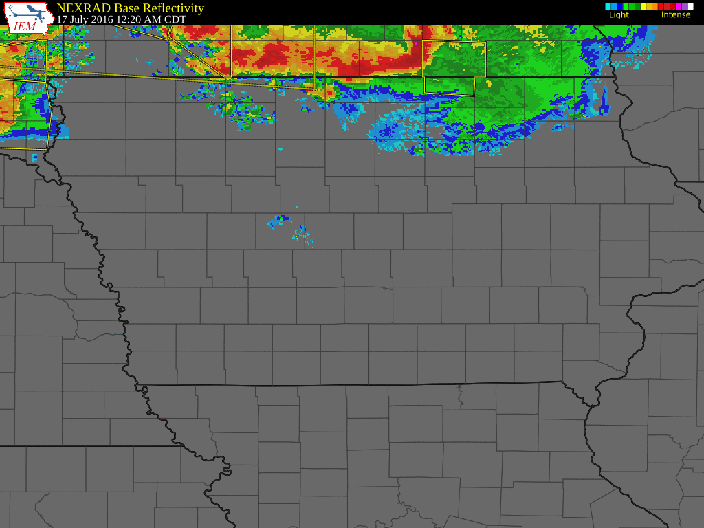 Radar loop and NWS warnings as the line of storms moved through central Iowa |
Photos & Radar:
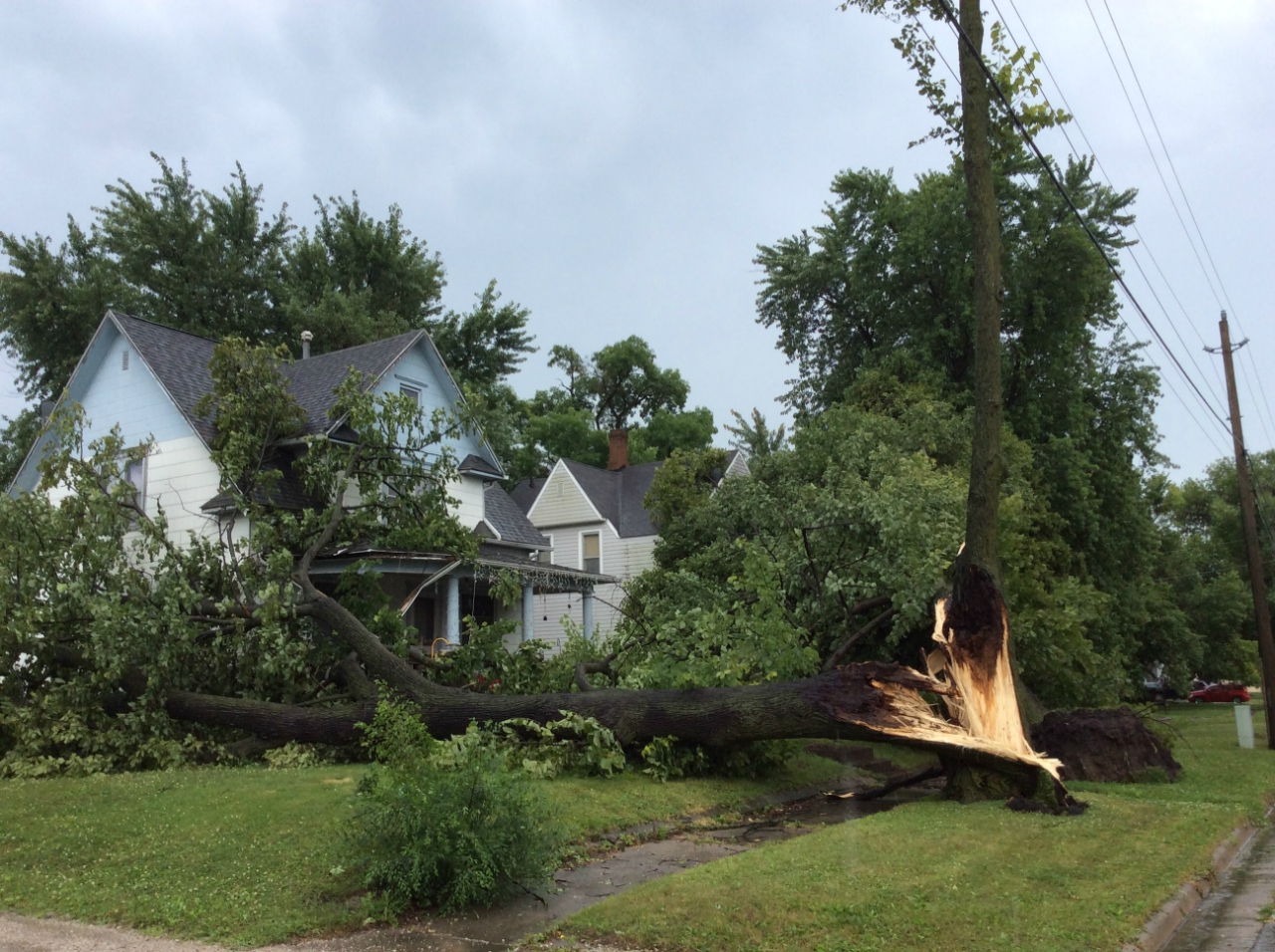
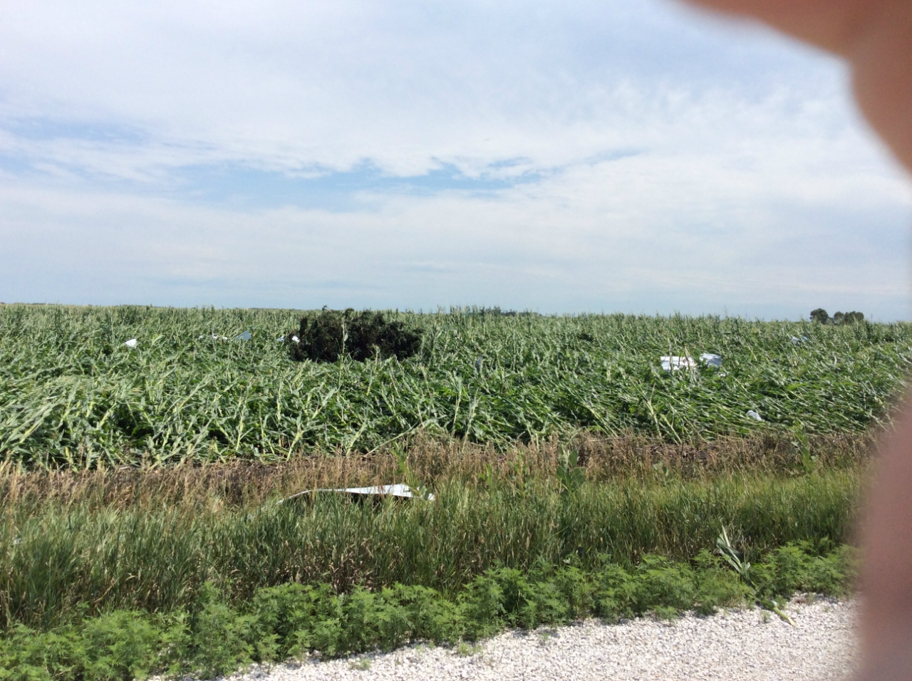
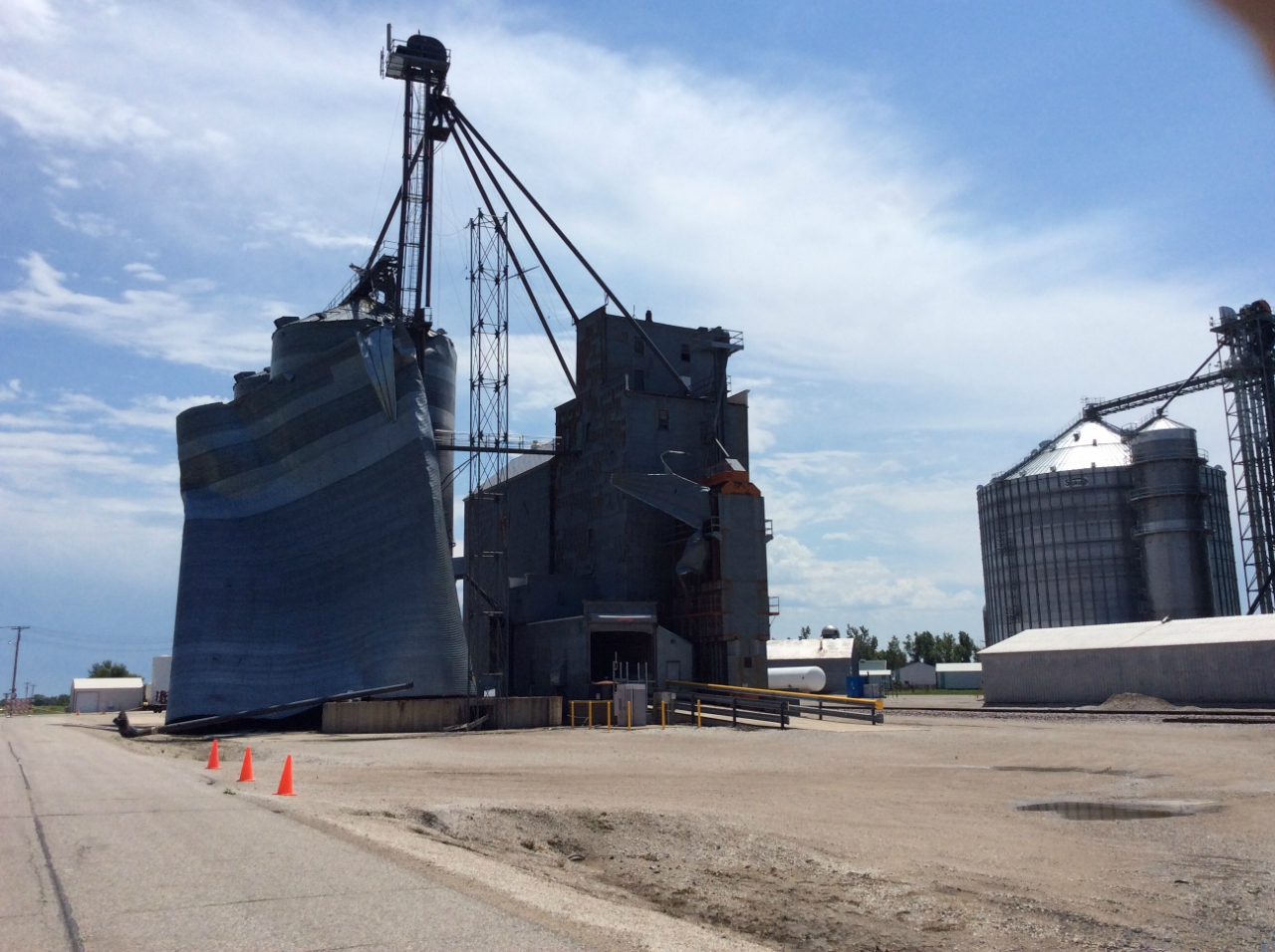
Damage Photos
 |
 |
 |
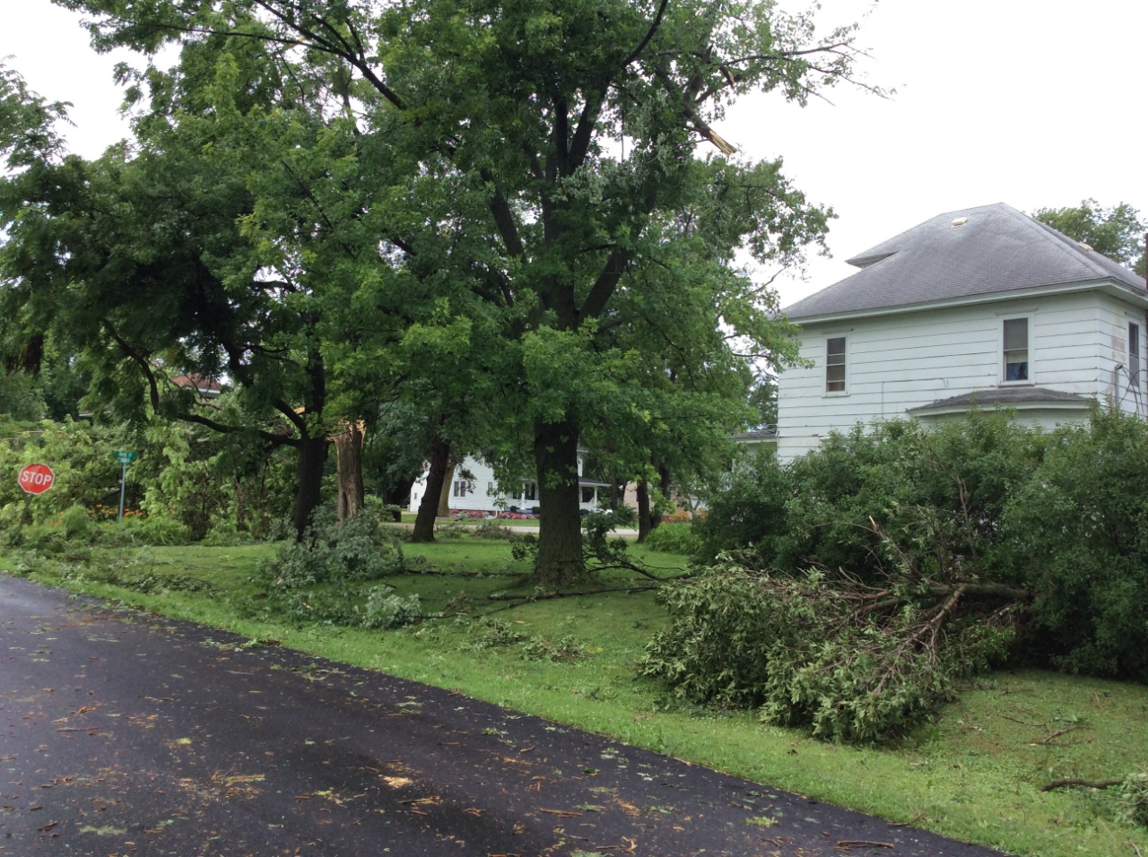 |
| Tree damage in Eagle Grove (NWS Storm Survey) |
Crops flattened NW of Renwick (NWS Storm Survey) |
Empty storage silo uplifted in Renwick (NWS Storm Survey) |
Tree damage in Renwick (NWS Storm Survey) |
Radar Images
 |
 |
 |
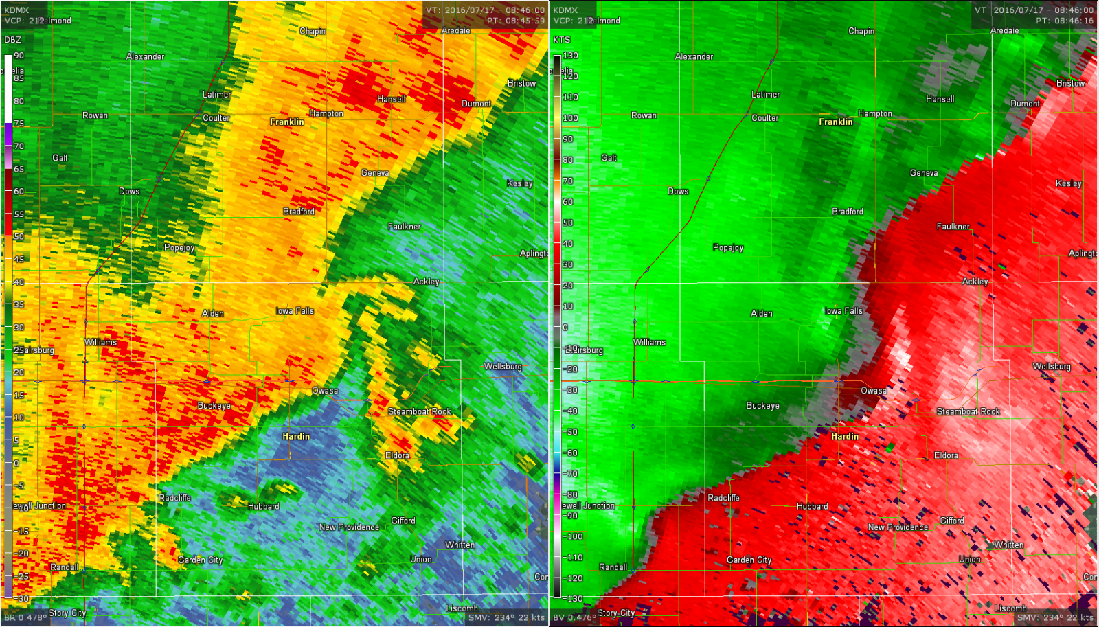 |
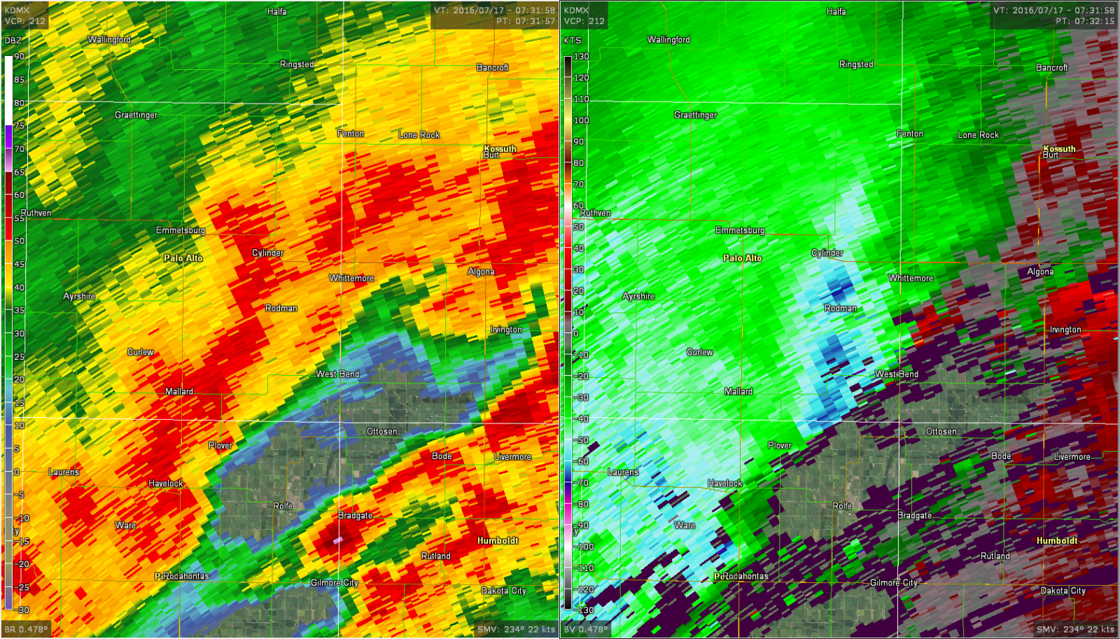
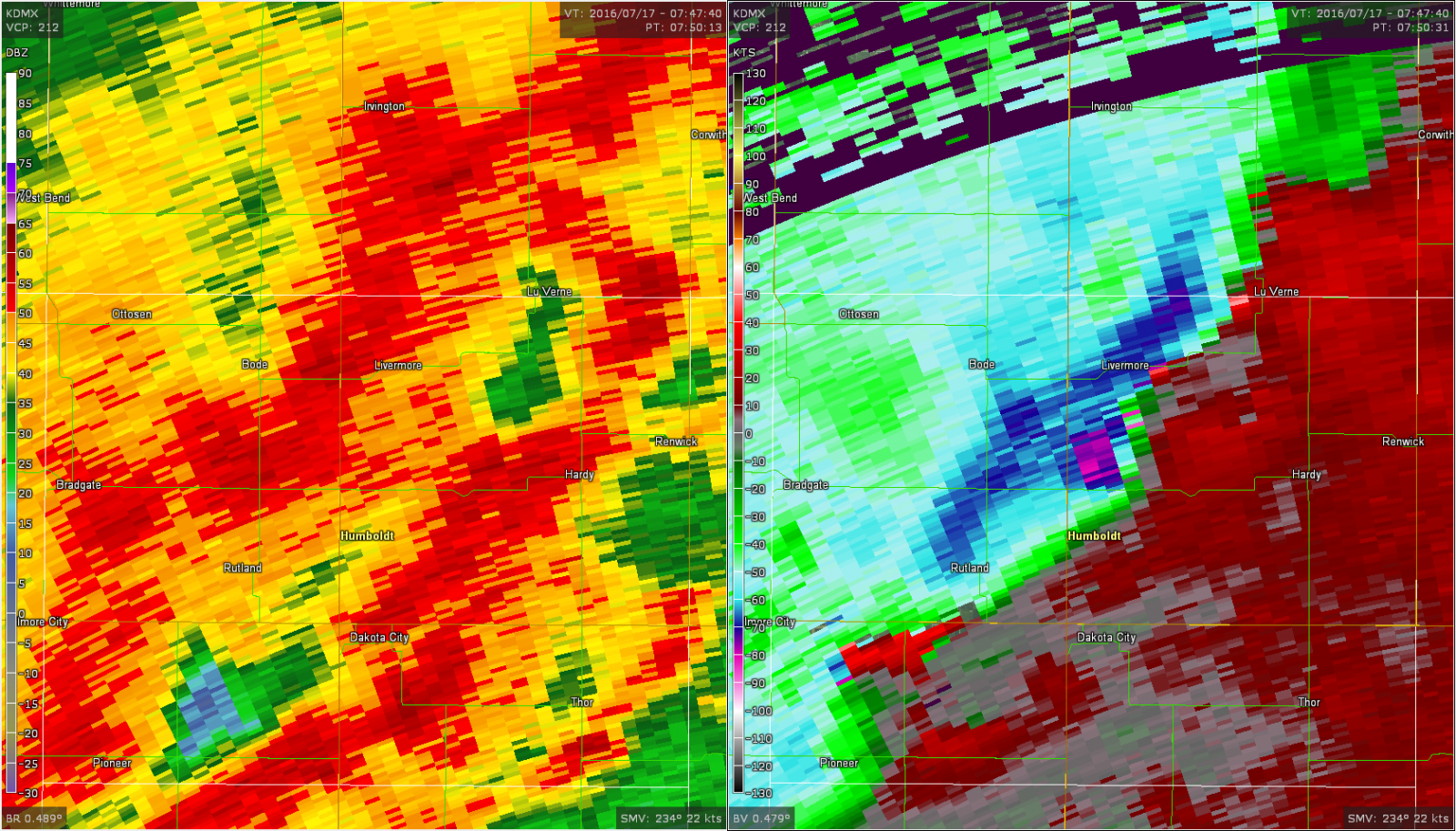
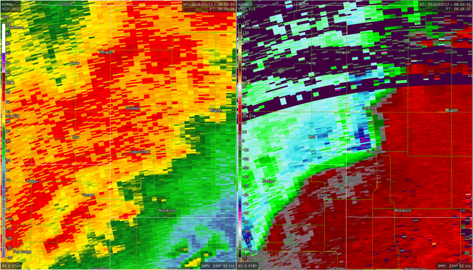
| 2:17am: The storm begins intensifying over Palo Alto County with winds of 60-75 mph visible on velocity (right image--reflectivity is on the left). | 2:50am: While the area of highest winds was difficult to determine on reflectivity, velocity data on the right highlighted a large area of 75-95mph winds. | 3:06am: Radar snapshot as the storms moved into Eagle Grove, with winds of 75-90 mph being measured aloft on velocity data. | 3:45am: As the storm shifted eastward, a mesovortex formed over Hardin County and helped concentrate the damage winds on a narrow path for many miles east. |
Storm Reports
PRELIMINARY LOCAL STORM REPORT...SUMMARY
NATIONAL WEATHER SERVICE DES MOINES IA
621 PM CDT SUN JUL 17 2016

..TIME...   ...EVENT...      ...CITY LOCATION...     ...LAT.LON...
..DATE...   ....MAG....      ..COUNTY LOCATION..ST.. ...SOURCE....
            ..REMARKS..

1120 AM     HAIL             HAMPTON                 42.74N 93.20W
07/17/2016  U1.00 INCH       FRANKLIN           IA   TRAINED SPOTTER

            MOSTLY PENNY SIZED HAIL WITH A FEW UP TO THE
            SIZE OF QUARTERS.

1035 AM     HAIL             2 E DUMONT              42.75N 92.94W
07/17/2016  E1.25 INCH       BUTLER             IA   LAW ENFORCEMENT

            SHERIFF REPORTED FEW HALF DOLLAR HAILSTONES
            ON HIGHWAY 3.

1033 AM     HAIL             DUMONT                  42.76N 92.98W
07/17/2016  E1.00 INCH       BUTLER             IA   PUBLIC

            PUBLIC REPORTED QUARTER SIZE HAIL ON THE NE
            SIDE OF DUMONT.

1013 AM     HAIL             DUMONT                  42.75N 92.98W
07/17/2016  M1.00 INCH       BUTLER             IA   TRAINED SPOTTER

            .

1012 AM     HAIL             HAMPTON                 42.75N 93.20W
07/17/2016  M1.00 INCH       FRANKLIN           IA   TRAINED SPOTTER

            .

0941 AM     HEAVY RAIN       3 SW MURRAY             41.01N 93.99W
07/17/2016  M1.40 INCH       CLARKE             IA   PUBLIC

            1.4 INCHES FELL IN 50 MINUTES.

0757 AM     TSTM WND DMG     2 NNW KENT              40.98N 94.46W
07/17/2016                   UNION              IA   EMERGENCY MNGR

            TREE LIMBS DOWN AND AN AUGER WAS BLOWN OVER.
            DAMAGE OCCURRED IN ADAMS COUNTY ON THE
            ADAMS/UNION COUNTY LINE.

0700 AM     HEAVY RAIN       1 SW NORTHWOOD          43.44N 93.23W
07/17/2016  M3.15 INCH       WORTH              IA   CO-OP OBSERVER

            CO OP OBSERVER MEASURED 3.15 INCHES OF TOTAL
            24 HOUR RAIN THROUGH 7 AM.

0700 AM     HEAVY RAIN       LAKE MILLS              43.42N 93.54W
07/17/2016  M3.72 INCH       WINNEBAGO          IA   CO-OP OBSERVER

            CO OP OBSERVER MEASURED 3.72 INCHES OF TOTAL
            24 HOUR RAIN THROUGH 7 AM.

0700 AM     HEAVY RAIN       RINGSTED                43.30N 94.51W
07/17/2016  M2.49 INCH       EMMET              IA   CO-OP OBSERVER

            CO OP OBSERVER MEASURED 2.49 INCHES OF TOTAL
            24 HOUR RAIN THROUGH 7 AM.

0700 AM     HEAVY RAIN       MASON CITY              43.15N 93.20W
07/17/2016  M3.03 INCH       CERRO GORDO        IA   CO-OP OBSERVER

            CO OP OBSERVER MEASURED 3.03 INCHES OF TOTAL
            24 HOUR RAIN THROUGH 7 AM.

0700 AM     HEAVY RAIN       3 NE CLEAR LAKE         43.16N 93.33W
07/17/2016  M2.74 INCH       CERRO GORDO        IA   ASOS

            MASON CITY ASOS MEASURED 2.74 INCHES OF RAIN
            THROUGH 7 AM.

0700 AM     HEAVY RAIN       FOREST CITY             43.26N 93.64W
07/17/2016  M2.60 INCH       WINNEBAGO          IA   CO-OP OBSERVER

            CO OP OBSERVER MEASURED 2.60 INCHES OF TOTAL
            24 HOUR RAIN THROUGH 7 AM.

0700 AM     HEAVY RAIN       ESTHERVILLE             43.40N 94.84W
07/17/2016  M2.08 INCH       EMMET              IA   CO-OP OBSERVER

            CO OP OBSERVER MEASURED 2.08 INCHES OF TOTAL
            24 HOUR RAIN THROUGH 7 AM.

0700 AM     HEAVY RAIN       2 WNW GRUVER            43.41N 94.75W
07/17/2016  M2.21 INCH       EMMET              IA   ASOS

            ESTHERVILLE ASOS MEASURED 2.21 INCHES OF
            RAIN THROUGH 7 AM.

0536 AM     HEAVY RAIN       1 NNW CLEAR LAKE        43.15N 93.38W
07/17/2016  M1.64 INCH       CERRO GORDO        IA   TRAINED SPOTTER

            TRAINED SPOTTER MEASURED 1.64 INCHES OF
            RAIN.

0435 AM     TSTM WND DMG     1 SSE ELK RUN HEIGHTS   42.45N 92.24W
07/17/2016                   BLACK HAWK         IA   BROADCAST MEDIA

            NUMEROUS 2 TO 6 INCH DIAMETER TREE LIMBS
            DOWN IN RAYMAR. RELAYED BY KWWL. TIME
            ESTIMATED FROM RADAR.

0435 AM     TSTM WND DMG     1 NNW GILBERTVILLE      42.44N 92.22W
07/17/2016                   BLACK HAWK         IA   PUBLIC

            A SHED AND A MORTON BUILDING PARTIALLY
            DESTROYED. NUMEROUS TREES AT LEAST 12 TO 18
            INCHES IN DIAMETER SNAPPED NEAR THE BASE.

0404 AM     TSTM WND GST     3 N STEAMBOAT ROCK      42.45N 93.06W
07/17/2016  M88 MPH          HARDIN             IA   MESONET

            STEAMBOAT ROCK RWIS MEASURED WIND OF 55MPH
            SUSTAINED AND 88MPH GUST.

0359 AM     TSTM WND DMG     2 W STEAMBOAT ROCK      42.41N 93.10W
07/17/2016                   HARDIN             IA   LAW ENFORCEMENT

            SEVERAL LARGE TREES AND POWER LINES DOWN IN
            STEAMBOAT ROCK. AT LEAST 2 POWER POLES
            SNAPPED IN HALF JUST WEST OF STEAMBOAT ROCK
            ON D35.

0356 AM     TSTM WND DMG     ACKLEY                  42.55N 93.05W
07/17/2016                   HARDIN             IA   LAW ENFORCEMENT

            SEVERAL POWER LINES AND LARGE TREES DOWN
            THROUGHOUT THE TOWN OF ACKLEY AS WELL AS
            OTHER PORTIONS OF HARDIN COUNTY.

0345 AM     FLASH FLOOD      MASON CITY              43.15N 93.20W
07/17/2016                   CERRO GORDO        IA   LAW ENFORCEMENT

            LAW ENFORCEMENT REPORTED 1ST STREET BLOCKED
            OFF AS WATER 3 TO 4 FEET DEEP SUBMERGED A
            VEHICLE. VARIOUS SPOTS OF WATER 4 TO 6
            INCHES DEEP ON ROADWAYS ACROSS MASON CITY.
            TIME AND LOCATION ESTIMATED.

0345 AM     FLASH FLOOD      ESTHERVILLE             43.40N 94.83W
07/17/2016                   EMMET              IA   LAW ENFORCEMENT

            6 TO 8 INCHES OF WATER ON A FEW ROADS IN
            ESTHERVILLE. ADDITIONAL REPORTS OF FARM
            FIELDS FLOODED. LOCATION AND TIME ESTIMATED.

0341 AM     TSTM WND DMG     1 N JEWELL              42.32N 93.64W
07/17/2016                   HAMILTON           IA   PUBLIC

            TREES AND LARGE BRANCHES DOWN AT JEWELL GOLF
            AND COUNTRY CLUB. REPORT VIA SOCIAL MEDIA. .

0337 AM     TSTM WND DMG     ALDEN                   42.52N 93.38W
07/17/2016                   HARDIN             IA   LAW ENFORCEMENT

            SEVERAL POWER LINES AND LARGE TREES DOWN
            THROUGHOUT THE TOWN OF ALDEN.

0337 AM     TSTM WND DMG     ALDEN                   42.52N 93.38W
07/17/2016                   HARDIN             IA   TRAINED SPOTTER

            TRAINED SPOTTER REPORTED SEVERAL 24 TO 36
            INCH TREES IN DIAMETER COMPLETELY GONE. 40
            FOOT TALL TREE DOWNED. ADDITIONAL TREE
            DOWNED ONTO NEARBY HOUSE. TIME AND LOCATION
            ESTIMATED FROM RADAR.

0308 AM     TSTM WND DMG     FORT DODGE              42.51N 94.18W
07/17/2016                   WEBSTER            IA   LAW ENFORCEMENT

            TREES DOWN AROUND TOWN.

0307 AM     TSTM WND GST     EAGLE GROVE             42.67N 93.90W
07/17/2016  E65 MPH          WRIGHT             IA   TRAINED SPOTTER

            PEAK WINDS ESTIMATED 60 TO 70 MPH.

0307 AM     TSTM WND DMG     1 SSW EAGLE GROVE       42.66N 93.90W
07/17/2016                   WRIGHT             IA   LAW ENFORCEMENT

            LAW ENFORCEMENT REPORTED DOWNED TREES AND
            DEBRIS BLOCKING ROADWAY IA 17. TIME
            ESTIMATED FROM RADAR.

0307 AM     TSTM WND DMG     EAGLE GROVE             42.67N 93.90W
07/17/2016                   WRIGHT             IA   LAW ENFORCEMENT

            SEVERAL TREES DOWN AROUND TOWN. TIME
            ESTIMATED.

0307 AM     TSTM WND DMG     1 WNW EAGLE GROVE       42.67N 93.92W
07/17/2016                   WRIGHT             IA   TRAINED SPOTTER

            SEVERAL LARGE TREES DOWN, EITHER SPLIT IN
            HALF OR COMPLETELY TOPPLED OVER, THROUGHOUT
            THE TOWN OF EAGLE GROVE. ONE LARGE TREE FELL
            ON A HOUSE ALONG WEST BROADWAY. SEVERAL
            TREES COVERING THE STREET NEAR THE
            INTERSECTION OF WEST BROADWAY AND FORT.

0303 AM     TSTM WND DMG     GOLDFIELD               42.74N 93.92W
07/17/2016                   WRIGHT             IA   LAW ENFORCEMENT

            MULTIPLE POWER LINES AND LARGE TREES DOWN
            FROM GOLDFIELD TO EAGLE GROVE.

0301 AM     TSTM WND DMG     2 E THOR                42.69N 94.01W
07/17/2016                   HUMBOLDT           IA   EMERGENCY MNGR

            4 MACHINE SHEDS DAMAGE/DESTROYED. TIME
            ESTIMATED FROM RADAR. .

0259 AM     TSTM WND DMG     THOR                    42.69N 94.05W
07/17/2016                   HUMBOLDT           IA   LAW ENFORCEMENT

            LARGE TREE FELL ON TOP OF A VEHICLE.

0259 AM     TSTM WND DMG     RENWICK                 42.83N 93.98W
07/17/2016                   HUMBOLDT           IA   LAW ENFORCEMENT

            ONE-THIRD OF A ROOF OFF AN IMPLEMENT AND
            FARM SUPPLY STORE. CAMPER ON ITS SIDE.
            MULTIPLE POWER LINES AND LARGE TREES DOWN
            THROUGHOUT THE TOWN BLOCKING MANY STREETS.
            GRAIN BIN COLLAPSED AT THE COOP.

0256 AM     TSTM WND DMG     4 NW RENWICK            42.87N 94.03W
07/17/2016                   HUMBOLDT           IA   EMERGENCY MNGR

            MACHINE SHED DESTROYED.

0249 AM     TSTM WND DMG     3 SW LIVERMORE          42.84N 94.23W
07/17/2016                   HUMBOLDT           IA   LAW ENFORCEMENT

            LAW ENFORCEMENT REPORTED A LARGE TREE DOWNED
            ONTO HWY 169.

0245 AM     FLASH FLOOD      1 S EMMETSBURG          43.10N 94.68W
07/17/2016                   PALO ALTO          IA   LAW ENFORCEMENT

            LAW ENFORCEMENT REPORTED VARIOUS LOCATIONS
            OF WATER 3 TO 5 INCHES DEEP ONTO ROADWAYS.
            TIME AND LOCATION ESTIMATED.

0237 AM     TSTM WND DMG     BURT                    43.20N 94.22W
07/17/2016                   KOSSUTH            IA   LAW ENFORCEMENT

            LAW ENFORCEMENT REPORTED A TREE DOWN ONTO A
            HOUSE. TIME AND LOCATION ESTIMATED.

0232 AM     TSTM WND DMG     LONE ROCK               43.22N 94.32W
07/17/2016                   KOSSUTH            IA   LAW ENFORCEMENT

            LAW ENFORCEMENT REPORTED A TREE AT LEAST 1
            FOOT IN DIAMETER DOWNED ONTO ROADWAY. TIME
            AND LOCATION ESTIMATED.

0215 AM     FLASH FLOOD      ESTHERVILLE             43.40N 94.83W
07/17/2016                   EMMET              IA   LAW ENFORCEMENT

            6 TO 8 INCHES OF WATER ON A FEW ROADS IN
            ESTHERVILLE. ADDITIONAL REPORTS OF FARM
            FIELDS FLOODED. LOCATION AND TIME ESTIMATED.

0208 AM     TSTM WND DMG     GRAETTINGER             43.24N 94.75W
07/17/2016                   PALO ALTO          IA   LAW ENFORCEMENT

            TREE UPROOTED. TIME ESTIMATED.
Additional NWS Storm Summaries
 |
Media use of NWS Web News Stories is encouraged! Please acknowledge the NWS as the source of any news information accessed from this site. |
|

