Overview
|
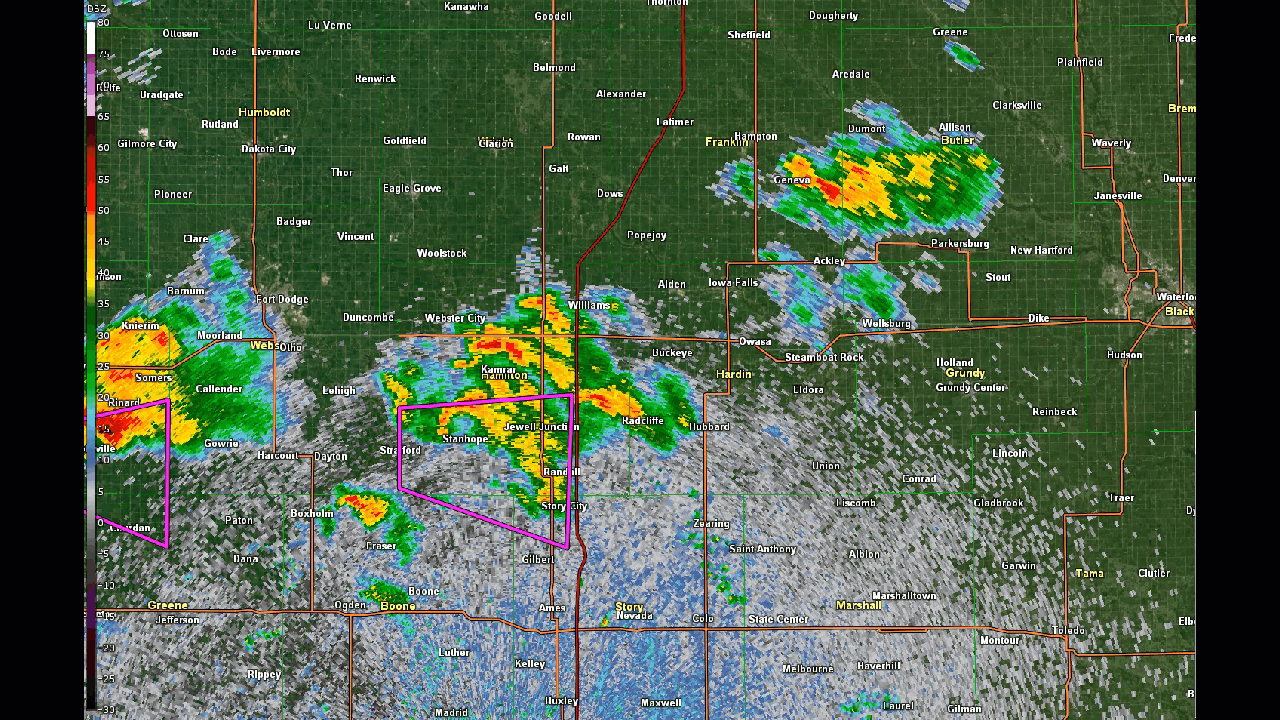
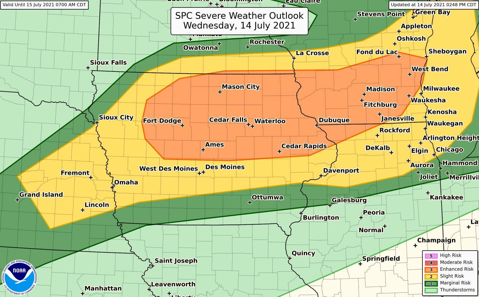
Supercells developed over portions of north-central Iowa on the afternoon of Wednesday, July 14, 2021. The environment was ripe for tornadic development and rotation was evident on radar shortly after storms formed. Generally south of along the Highway 20 corridor was the hot spot for tornadoes from around Nemaha, Lake City, Stanhope, Jewell, and Waverly. Tornadoes were reported around Dysart and south of Mason City. Heavy rain caused flash flooding in Maxwell and ping pong hail was reported in Clarksville.
Other NWS Office Event Summaries: NWS Quad Cities | NWS La Crosse
The latest updates:
Last update: July 25, 2021 7:54 p.m. CDT |
.jpg) Tornado between Stanhope and Radcliffe. Photo courtesy of Hunter Fowkes. |
.jpg) |
 |
.jpg) |
| Tornado between Stanhope to Jewell. Photo courtesy of @BTravs. | Tornado near Sac City. Photo courtesy of @MrJPE. | Tornado near Gowrie. Photo courtesy of @adamorgler. |
Tornadoes
|
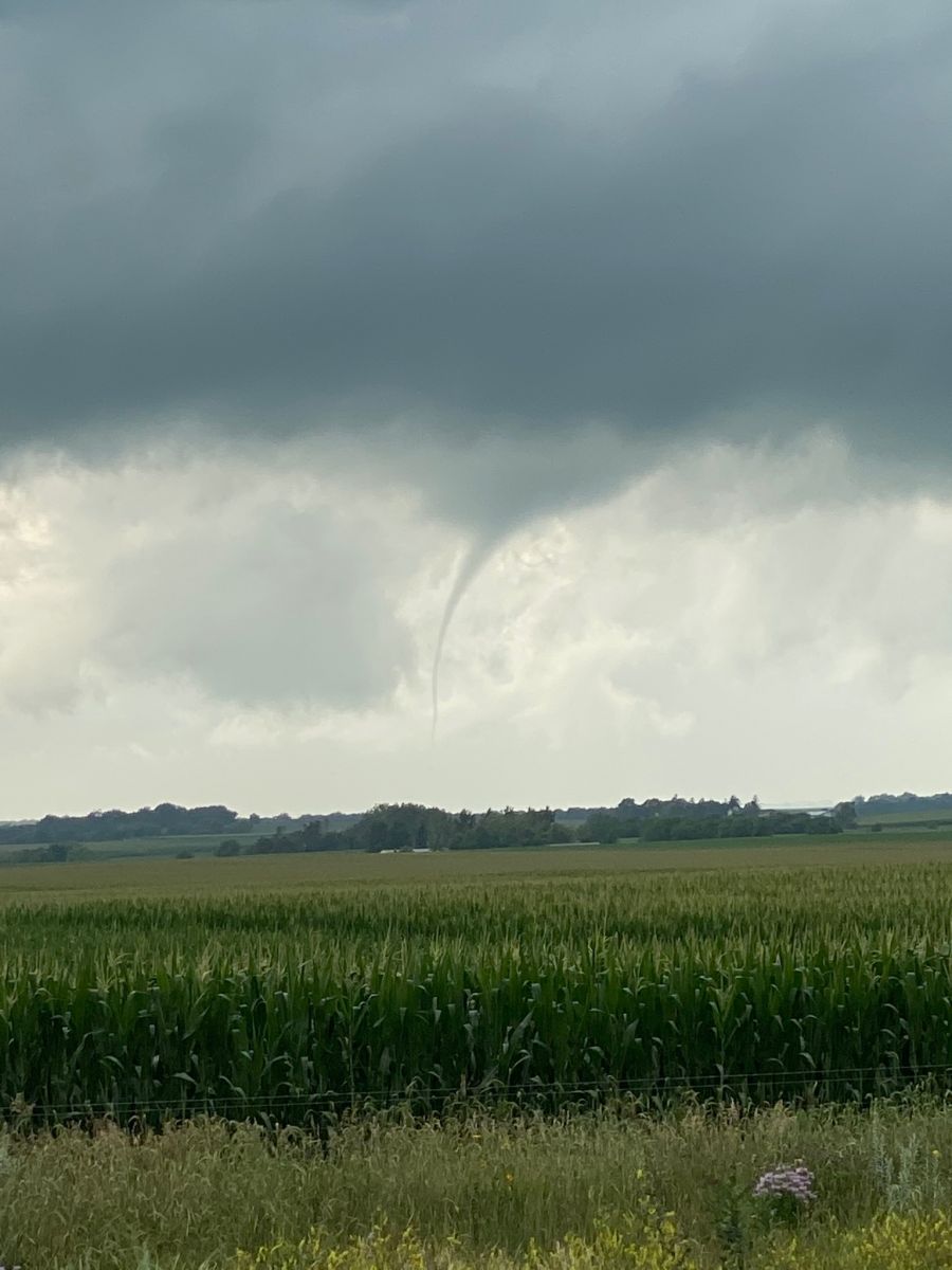
Tornado #1 - Lake City
Track Map 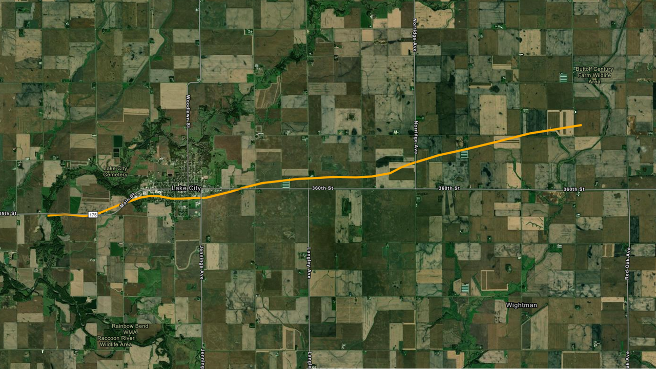 
Downloadable KMZ File |
||||||||||||||||
|
Tornado #2 - Stratford to Stanhope
Track Map 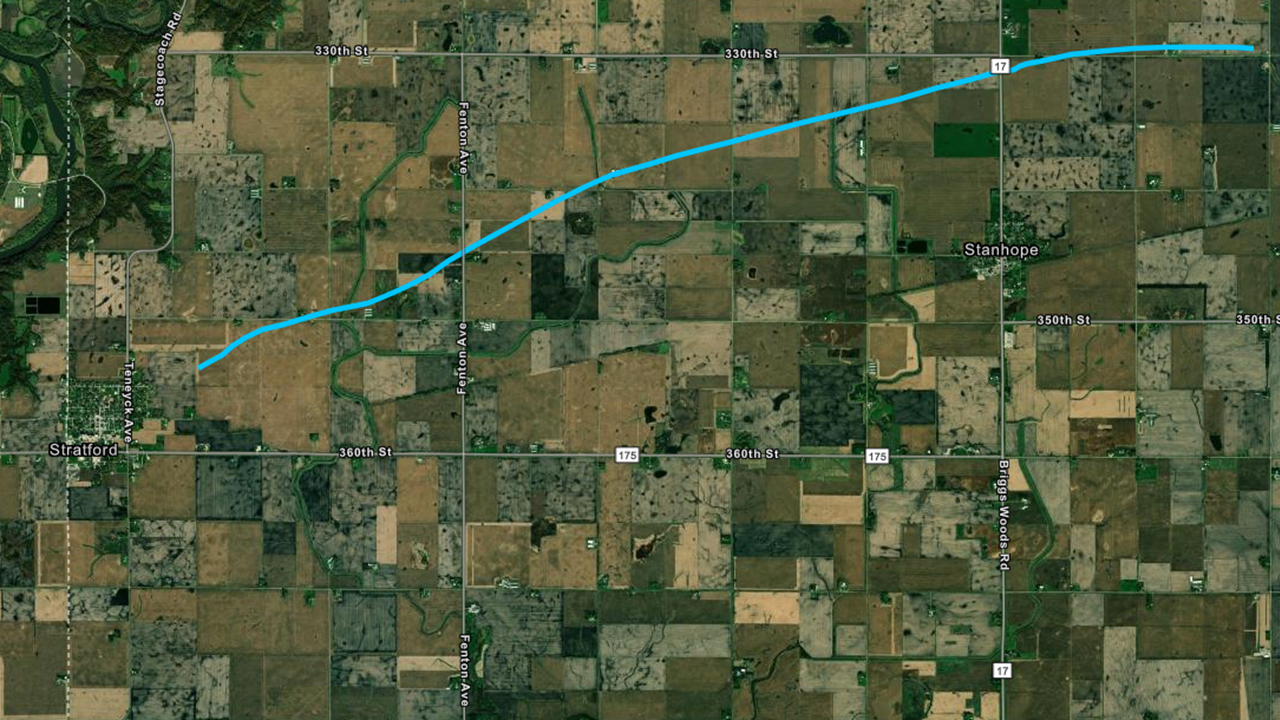
Downloadable KMZ File |
||||||||||||||||
|
Tornado #3 - Jewell
Track Map 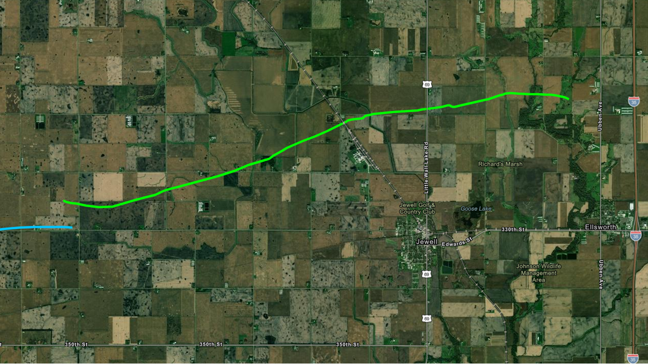
Downloadable KMZ File |
||||||||||||||||
|
Tornado #4 - Gowrie
Track Map 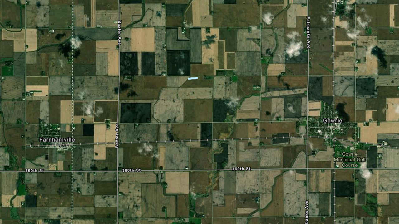
Downloadable KMZ File |
||||||||||||||||
|
Tornado #5 - Shell Rock to Waverly
Track Map 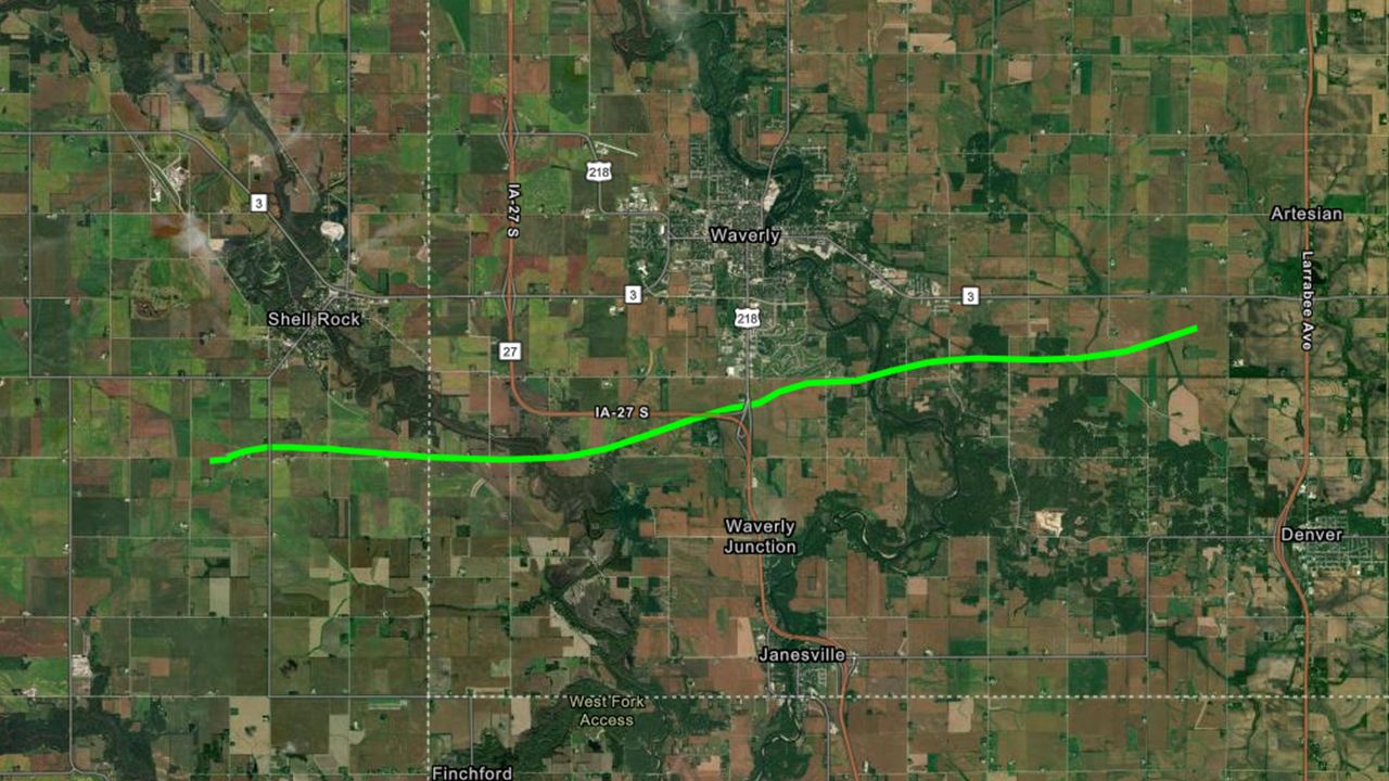
Downloadable KMZ File |
||||||||||||||||
|
Tornado #6 - Dysart
Track Map 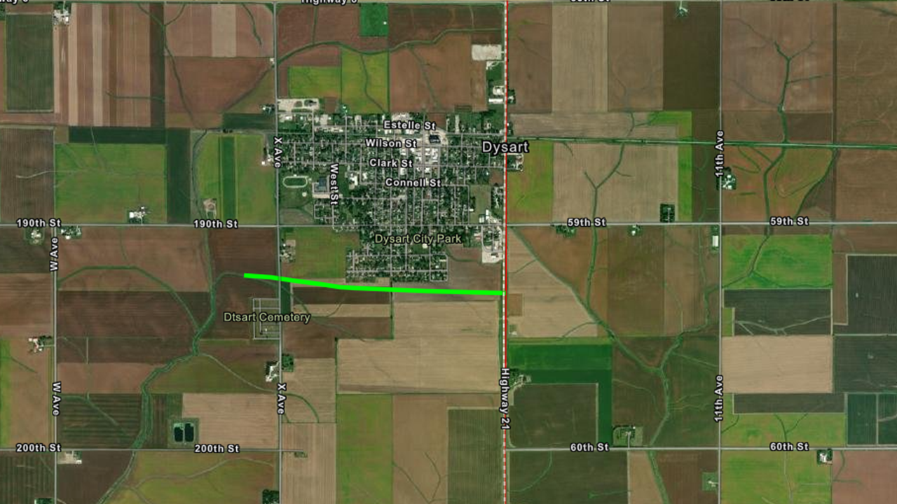
Downloadable KMZ File |
||||||||||||||||
|
Tornado #7 - Rockwell
Track Map 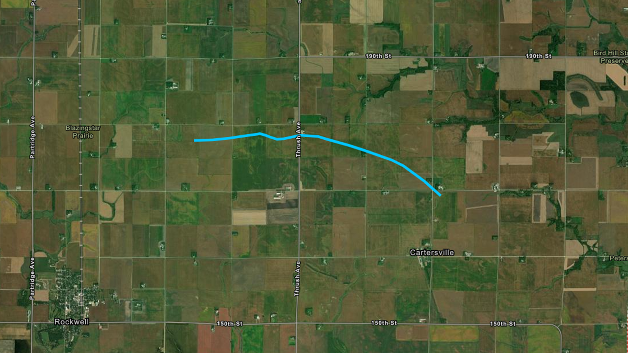
Downloadable KMZ File |
||||||||||||||||
|
Tornado #8 - Sac City
Track Map 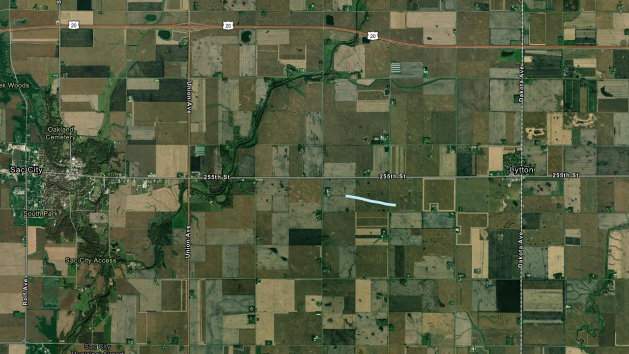
Downloadable KMZ File |
||||||||||||||||
|
Tornado #9 - 6 E of Readlyn
Track Map 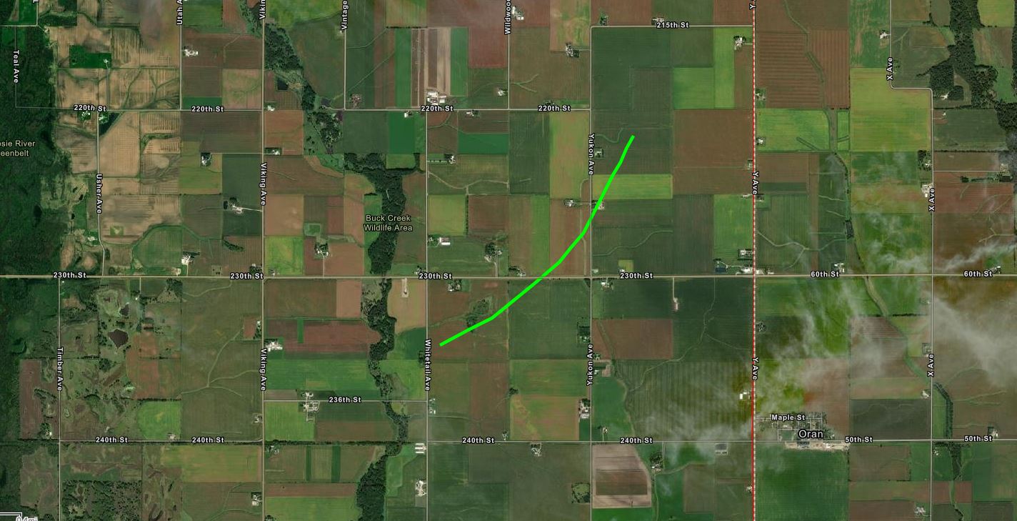
Downloadable KMZ File |
||||||||||||||||
|
Tornado #10 - LOCATION
Track Map
Downloadable KMZ File |
||||||||||||||||
The Enhanced Fujita (EF) Scale classifies tornadoes into the following categories:
| EF0 Weak 65-85 mph |
EF1 Moderate 86-110 mph |
EF2 Significant 111-135 mph |
EF3 Severe 136-165 mph |
EF4 Extreme 166-200 mph |
EF5 Catastrophic 200+ mph |
 |
|||||
Photos & Video
Photos from around central Iowa showing the tornadoes and their damage from July 14, 2021.
Additional photos/videos on this Twitter Moment
 |
 |
 |
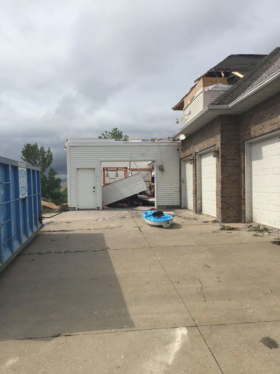 |
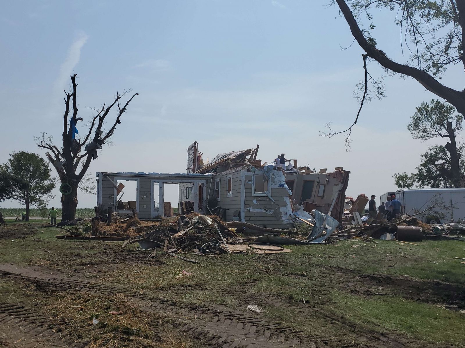
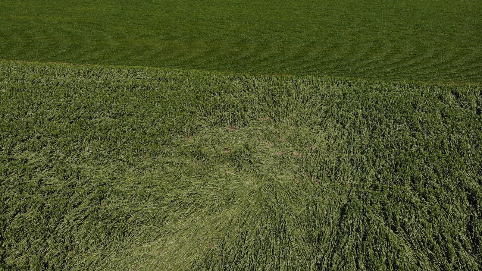
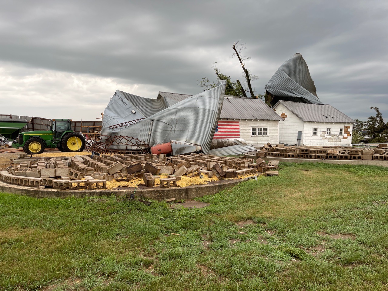
| Home significantly damaged in Lake City, Iowa. Photo taken during NWS storm survey. | Tornado track visible within corn field in Bremer County, Iowa. Photo courtesy of Emergency Manager Kip Ladage | Damage to grain bins and trees in Shell Rock, Iowa. Photo courtesy of Emergency Manager Chris Showalter | Home significantly damaged in Dysart, Iowa. Photo taken during NWS storm survey. |
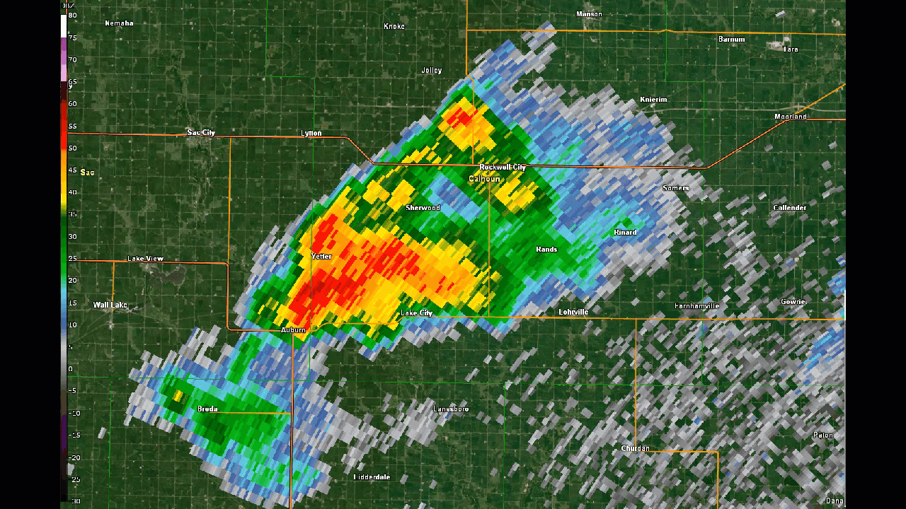
Radar
 |
| Radar loop of July 14, 2021. From the Iowa Environmental Mesonet |
 |
 |
 |
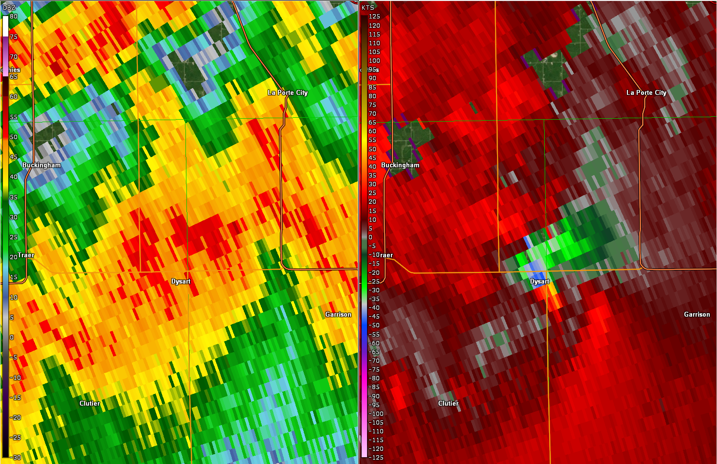 |
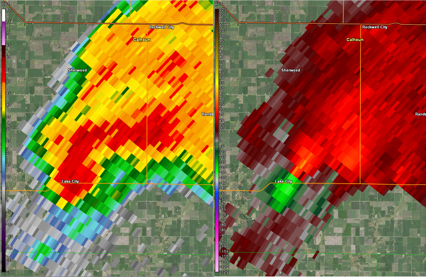
| Lake City, Iowa radar loop | North-central Iowa radar loop | Lake City reflectivity (left) and velocity (right) | Dysart reflectivity (left) and velocity (right) |
Satellite
Various satellite imagery from July 14, 2021 from GOES-East courtesy of RAMMB/CIRA at Colorado State University.
For best viewing, view full screen and adjust quality (gear in bottom right of video) to 1080p.
| 24 hour fast loop of GOES-East 5 minute clean infrared imagery starting on July 14, 2021 at 7am | Fast loop during the daytime on July 14, 2021 from GOES-East 5 minute visible imagery |
| Fast loop of GOES-East 1 minute clean infrared loop on July 14, 2021 | Fast loop of 1 minute GOES-East Day Cloud Phase Distinction Loop on July 14, 2021 |
| GOES-East 1 minute visible/clean infrared sandwich loop during peak tornado time - July 14, 2021 |
Fast loop of GOES-East 1 minute visible imagery on July 14, 2021 |
| Fast loop of 1 minute GeoColor with Lightning on July 14, 2021 | Fast loop of 1 minute GeoColor on July 14, 2021 |
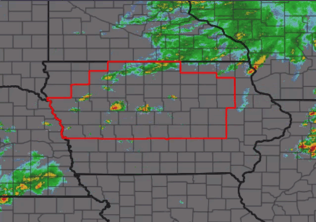
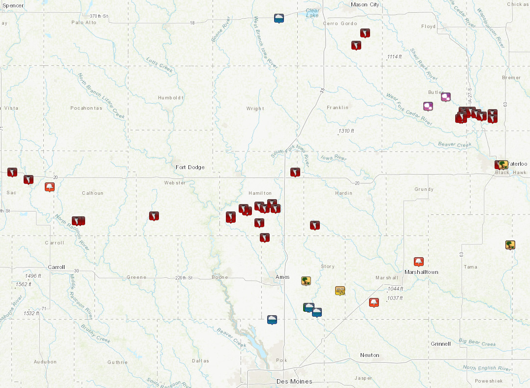
Storm Reports
Preliminary storm report map. Note that the number of tornado icons does not equal number of tornadoes as some tornadoes have multiple reports.
Click map below to go to an interactive map viewer
PRELIMINARY LOCAL STORM REPORT...SUMMARY
NATIONAL WEATHER SERVICE DES MOINES IA
531 AM CDT THU JUL 15 2021

..TIME...   ...EVENT...      ...CITY LOCATION...     ...LAT.LON...
..DATE...   ....MAG....      ..COUNTY LOCATION..ST.. ...SOURCE....
            ..REMARKS..

0841 AM     TSTM WND DMG     NEVADA                  42.02N 93.45W
07/14/2021                   STORY              IA   EMERGENCY MNGR

            TREES ON POWER LINES.

0228 PM     HEAVY RAIN       GARNER                  43.10N 93.60W
07/14/2021  M2.00 INCH       HANCOCK            IA   PUBLIC


0401 PM     TORNADO          LAKE CITY               42.27N 94.73W
07/14/2021                   CALHOUN            IA   LAW ENFORCEMENT

            RELAYED BY IOWA STATE PATROL.

0401 PM     TORNADO          LAKE CITY               42.27N 94.73W
07/14/2021                   CALHOUN            IA   TRAINED SPOTTER

            DAMAGE ON THE SOUTH SIDE OF LAKE CITY. TREES
            DOWN AND POWER LINES DOWN.

0401 PM     TORNADO          LAKE CITY               42.27N 94.73W
07/14/2021                   CALHOUN            IA   LAW ENFORCEMENT

            IOWA STATE PATROL REPORTS TREES DOWN IN LAKE
            CITY. TIME ESTIMATED.

0401 PM     TORNADO          1 ENE LAKE CITY         42.27N 94.71W
07/14/2021                   CALHOUN            IA   LAW ENFORCEMENT

            IOWA STATE PATROL REPORTS CONSIDERABLE
            DAMAGE TO A HOUSEY. TIME ESTIMATED.

0406 PM     TORNADO          3 ENE STRATFORD         42.28N 93.87W
07/14/2021                   HAMILTON           IA   LAW ENFORCEMENT

            TORNADO TOUCHED DOWN AND THEN LIFTED. MAY BE
            CYCLING WITH A FURTHER TOUCHDOWN.

0409 PM     TORNADO          3 ENE STRATFORD         42.29N 93.87W
07/14/2021                   HAMILTON           IA   TRAINED SPOTTER

            MULTI-VORTEX TORNADO.

0420 PM     TORNADO          5 W STORY CITY          42.20N 93.68W
07/14/2021                   STORY              IA   LAW ENFORCEMENT


0421 PM     TORNADO          2 NNE STANHOPE          42.31N 93.78W
07/14/2021                   HAMILTON           IA   TRAINED SPOTTER

            TORNADO ON THE GROUND NEAR 330TH STREET AND
            KANTO AVENUE NORTHEAST OF STANHOPE.

0423 PM     TORNADO          2 SW WAVERLY            42.71N 92.50W
07/14/2021                   BREMER             IA   TRAINED SPOTTER


0423 PM     TORNADO          5 ESE STANHOPE          42.26N 93.71W
07/14/2021                   HAMILTON           IA   TRAINED SPOTTER

            LOCATION APPROXIMATE. TORNADO CYCLED UP AND
            WAS ON GROUND AT THE TIME OF THIS REPORT.
            REPORT RELAYED BY EMA.

0425 PM     TORNADO          2 N STANHOPE            42.32N 93.80W
07/14/2021                   HAMILTON           IA   TRAINED SPOTTER

            ROPE TORNADO JUST TOUCHED DOWN AGAIN.

0430 PM     TORNADO          4 WNW JEWELL            42.33N 93.71W
07/14/2021                   HAMILTON           IA   LAW ENFORCEMENT

            TORNADO REPORTED WEST OF JEWELL.

0433 PM     TORNADO          2 W JEWELL              42.32N 93.68W
07/14/2021                   HAMILTON           IA   LAW ENFORCEMENT

            REPORTED BY SHERIFFS OFFICE. TORNADO WAS
            HEADING EAST.

0433 PM     TORNADO          2 N JEWELL              42.34N 93.64W
07/14/2021                   HAMILTON           IA   PUBLIC

            DEBRIS REPORTED TORNADO NEAR HIGHWAY 69.

0437 PM     TORNADO          2 N JEWELL              42.34N 93.64W
07/14/2021                   HAMILTON           IA   LAW ENFORCEMENT

            LAW ENFORCEMENT REPORTS A TORNADO AT 310TH
            ST AND HWY 69 NORTH OF JEWELL. TORNADO WENT
            UP BRIEFLY BUT TOUCHED BACK DOWN AND HAS
            DEBRIS. IT IS HEADING EAST.

0440 PM     TORNADO          1 NE JEWELL             42.32N 93.62W
07/14/2021                   HAMILTON           IA   TRAINED SPOTTER

            TRAINED SPOTTER REPORTED A TORNADO STILL ON
            THE GROUND ABOUT A MILE NORTHEAST OF JEWELL.
            SOME DAMAGE SEEN BUT UNKNOWN WHAT WAS HIT.
            SPOTTER CONFIRMED IT DID GO NORTH OF TOWN.

0446 PM     TORNADO          1 NW GOWRIE             42.29N 94.30W
07/14/2021                   WEBSTER            IA   LAW ENFORCEMENT

            DNR LAW ENFORCEMENT OFFICER REPORTS A
            TORNADO ALONG 340TH ST.

0448 PM     HAIL             2 SE ALLISON            42.74N 92.77W
07/14/2021  U0.75 INCH       BUTLER             IA   PUBLIC

            REPORT FROM MPING: DIME (0.75 IN.).

0450 PM     TORNADO          2 SE WILLIAMS           42.47N 93.51W
07/14/2021                   HAMILTON           IA   TRAINED SPOTTER

            TORNADO NEAR THE INTERCHANGE OF US HWY 20
            AND CO RD R77.

0509 PM     TORNADO          5 SSE RADCLIFFE         42.25N 93.40W
07/14/2021                   HARDIN             IA   LAW ENFORCEMENT

            CONFIRMED TORNADO AND DAMAGE IN GARDEN CITY.
            TIME ESTIMATED FROM RADAR.

0511 PM     TORNADO          3 S NEMAHA              42.47N 95.09W
07/14/2021                   SAC                IA   PUBLIC

            REPORT FROM SOCIAL MEDIA.

0514 PM     HAIL             CLARKSVILLE             42.78N 92.67W
07/14/2021  E1.25 INCH       BUTLER             IA   NWS EMPLOYEE


0516 PM     TORNADO          2 SSW SHELL ROCK        42.69N 92.59W
07/14/2021                   BUTLER             IA   EMERGENCY MNGR

            DAMAGE BEGINS AROUND 250TH AND WILLOW
            AVENUE. HOUSES DAMAGED. GRAIN BINS DAMAGED.
            POWER LINES DOWN. DAMAGE PARALLELED 250TH
            EAST.

0518 PM     TORNADO          1 NE SHELL ROCK         42.72N 92.57W
07/14/2021                   BUTLER             IA   BROADCAST MEDIA

            KGAN METEOROLOGIST REPORTS TORNADO NEAR
            SHELL ROCK.

0519 PM     TORNADO          1 E SHELL ROCK          42.71N 92.56W
07/14/2021                   BUTLER             IA   TRAINED SPOTTER

            NO DAMAGE SEEN YET.

0519 PM     TORNADO          2 S SHELL ROCK          42.69N 92.58W
07/14/2021                   BUTLER             IA   BROADCAST MEDIA

            DAMAGE TO TREES AND A HOME NEAR 250TH AND
            WOODS AVE. REPORT COURTESY IOWAS NEWS NOW.
            TIME ESTIMATED BY RADAR.

0520 PM     TORNADO          1 N SAC CITY            42.44N 95.00W
07/14/2021                   SAC                IA   TRAINED SPOTTER

            VERY BRIEF SKINNY ROPE TORNADO. NO DAMAGE
            SEEN. REPORT VIA SOCIAL MEDIA.

0520 PM     TORNADO          1 N SAC CITY            42.44N 95.00W
07/14/2021                   SAC                IA   TRAINED SPOTTER

            VERY BRIEF SKINNY ROPE TORNADO. NO DAMAGE
            SEEN. REPORT VIA SOCIAL MEDIA.

0521 PM     TORNADO          2 ENE SHELL ROCK        42.72N 92.53W
07/14/2021                   BREMER             IA   STORM CHASER

            REPORT VIA SOCIAL MEDIA. PHOTOS AND VIDEOS
            REPORTED.

0525 PM     TORNADO          2 SW WAVERLY            42.71N 92.50W
07/14/2021                   BREMER             IA   LAW ENFORCEMENT

            TORNADO REPORTED NEAR THE INTERSECTION OF
            240TH ST AND HWY 218. TORNADO HEADING EAST.

0528 PM     TORNADO          1 S SHELL ROCK          42.70N 92.58W
07/14/2021                   BUTLER             IA   TRAINED SPOTTER

            SIGNIFICANT TREE DAMAGE AND LIGHT STRUCTURE
            DAMAGE.

0535 PM     TORNADO          2 S WAVERLY             42.70N 92.47W
07/14/2021                   BREMER             IA   TRAINED SPOTTER

            TORNADO ON THE GROUND. DEBRIS BEING LOFTED
            INTO THE AIR.

0535 PM     TORNADO          3 ESE WAVERLY           42.71N 92.41W
07/14/2021                   BREMER             IA   LAW ENFORCEMENT

            HOUSE COMPLETELY DESTROYED.

0537 PM     TORNADO          2 S WAVERLY             42.70N 92.47W
07/14/2021                   BREMER             IA   STORM CHASER

            REPORT VIA SOCIAL MEDIA.

0539 PM     TORNADO          4 WNW DENVER            42.69N 92.41W
07/14/2021                   BREMER             IA   TRAINED SPOTTER

            TORNADO ON THE GROUND. DEBRIS BEING LOFTED
            INTO THE AIR.

0546 PM     FUNNEL CLOUD     1 SW LYTTON             42.41N 94.88W
07/14/2021                   SAC                IA   STORM CHASER

            REPORT VIA SOCIAL MEDIA.

0602 PM     FUNNEL CLOUD     7 NE MARSHALLTOWN       42.10N 92.82W
07/14/2021                   MARSHALL           IA   LAW ENFORCEMENT

            MULTIPLE REPORTS OF FUNNEL CLOUD NEAR GREEN
            MOUNTAIN AROUND 170TH AND WALLACE AVE.

0605 PM     TORNADO          1 NE ROCKWELL           42.99N 93.17W
07/14/2021                   CERRO GORDO        IA   TRAINED SPOTTER


0606 PM     TORNADO          5 NE ROCKWELL           43.04N 93.12W
07/14/2021                   CERRO GORDO        IA   PUBLIC

            PUBLIC REPORT OF TORNADO ON GROUND.

0617 PM     TSTM WND DMG     WATERLOO                42.50N 92.35W
07/14/2021                   BLACK HAWK         IA   TRAINED SPOTTER

            NUMEROUS TREES DOWN. TIME ESTIMATED FROM
            RADAR.

0619 PM     TORNADO          1 NW WATERLOO           42.50N 92.37W
07/14/2021                   BLACK HAWK         IA   TRAINED SPOTTER

            DELAYED REPORT: BRIEF TORNADO TOUCHDOWN NEAR
            JOHN DEERE COMPLEX WITH SOME DAMAGE REPORTED
            EITHER SIDE OF US 218 FROM MAYNARD &
            ANSBOROUGH AVE SOUTH TOWARD WESTFILED AVE.

0619 PM     TORNADO          1 NW WATERLOO           42.50N 92.36W
07/14/2021                   BLACK HAWK         IA   TRAINED SPOTTER

            DELAYED REPORT - BRIEF TORNADO TOUCHDOWN
            NEAR JOHN DEERE COMPLEX WITH SOME DAMAGE
            EITHER SIDE OF US 218.

0619 PM     TORNADO          1 NW WATERLOO           42.50N 92.37W
07/14/2021                   BLACK HAWK         IA   TRAINED SPOTTER

            BRIEF TORNADO REPORTED NEAR THE JOHN DEERE
            FACILITY WITH DAMAGE REPORTED NEAR US 218.

0622 PM     TSTM WND DMG     WATERLOO                42.50N 92.35W
07/14/2021                   BLACK HAWK         IA   TRAINED SPOTTER

            TREES DOWN. TIME ESTIMATED.

0705 PM     TORNADO          DYSART                  42.17N 92.31W
07/14/2021                   TAMA               IA   EMERGENCY MNGR

            STRUCTURAL DAMAGE TO BUILDINGS. TIME
            ESTIMATED FROM RADAR.

0724 PM     TSTM WND DMG     DYSART                  42.17N 92.31W
07/14/2021                   TAMA               IA   FIRE DEPT/RESCUE

            DYSART FIRE CALLED OUT FOR A DOWNED
            TRANSFORMER THAT STARTED A FIRE.

0815 PM     FUNNEL CLOUD     2 ESE MELBOURNE         41.93N 93.07W
07/14/2021                   MARSHALL           IA   TRAINED SPOTTER

            TRAINED SPOTTER REPORTS BRIEF FUNNEL CLOUD 2
            MILES ESE OF MELBOURNE.

0823 PM     TSTM WND GST     4 SE COLO               41.98N 93.26W
07/14/2021  E60 MPH          STORY              IA   TRAINED SPOTTER

            LARGE TREE BRANCHES DOWN.

0830 PM     FLASH FLOOD      3 WNW MAXWELL           41.91N 93.44W
07/14/2021                   STORY              IA   LAW ENFORCEMENT

            REPORT OF WATER OVER THE ROAD AT 305TH ST
            AND 630TH AVE. 3 TO 4 INCHES OF RAINFALL IN
            THIS AREA.

0840 PM     HEAVY RAIN       2 NW MAXWELL            41.91N 93.43W
07/14/2021  M5.60 INCH       STORY              IA   TRAINED SPOTTER

            TOTAL RAINFALL SINCE ABOUT 6 PM.

0902 PM     FLASH FLOOD      MAXWELL                 41.89N 93.39W
07/14/2021                   STORY              IA   TRAINED SPOTTER

            WATER OVER INTERSECTION OF WOODLAWN AND 2ND
            STREET OF AT LEAST 6 INCHES DEEP. REPORT VIA
            SOCIAL MEDIA.

0907 PM     HEAVY RAIN       3 SE SLATER             41.86N 93.64W
07/14/2021  M3.40 INCH       POLK               IA   TRAINED SPOTTER


0929 PM     HEAVY RAIN       MAXWELL                 41.89N 93.39W
07/14/2021  M5.20 INCH       STORY              IA   PUBLIC


0227 AM     HEAVY RAIN       HUMESTON                40.86N 93.50W
07/15/2021  M2.22 INCH       WAYNE              IA   TRAINED SPOTTER

            RAIN STARTED AROUND 1230AM.

0500 AM     HEAVY RAIN       ALBIA                   41.03N 92.80W
07/15/2021  M2.51 INCH       MONROE             IA   TRAINED SPOTTER

            OVERNIGHT RAINFALL.
Environment
 |
 |
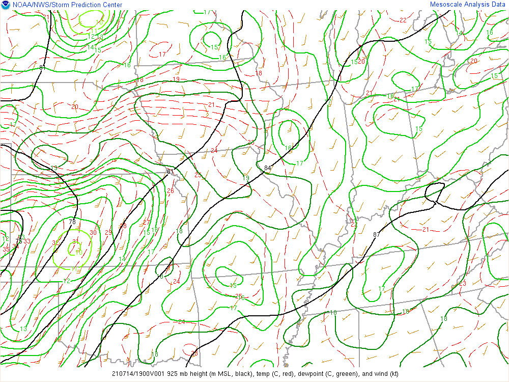 |
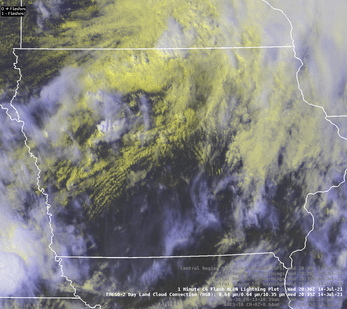
| Figure 1: Storm Prediction Center Severe Weather Outlook for July 14, 2021. | Figure 2: Full satellite and lightning detection loop of storm evolution. | Figure 3: Storms developed along a warm front across northern Iowa within a moisture rich environment with dewpoints surpassing 70F. |
 |
 |
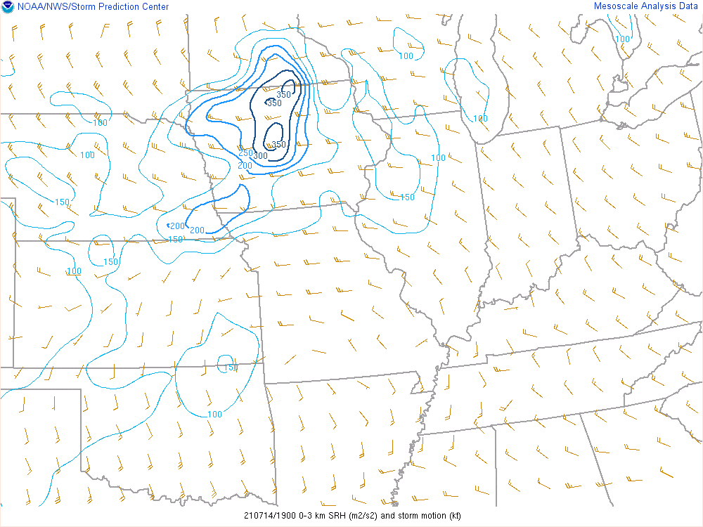 |
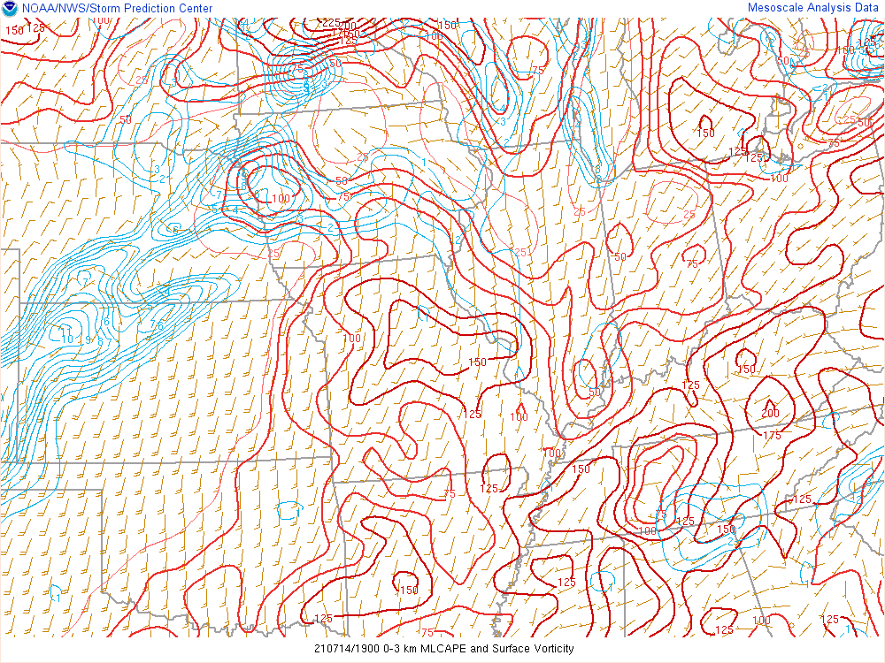
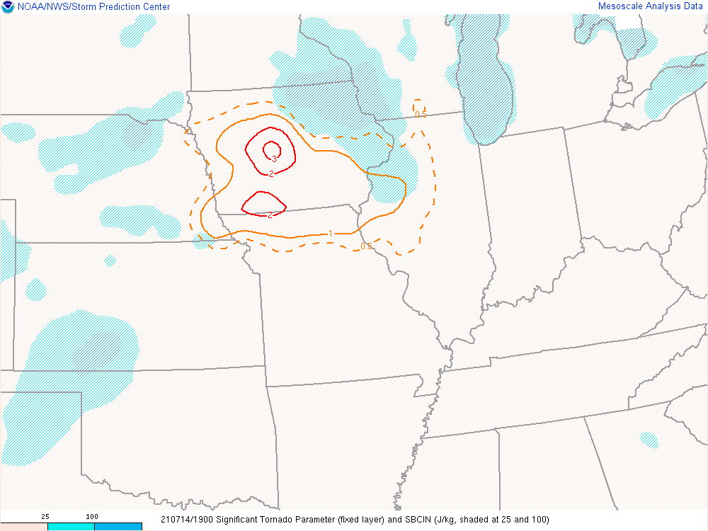
| Figure 4: 0-3 KM CAPE values tend to support tornado formation when co-located with significant vorticity. | Figure 5: Significant Tornado Parameter (STP) maximum over north central Iowa. Most significant tornadoes (EF-2 or greater) have been associated with a STP values greater than 1. Find more info here on this parameter. | Figure 6: Effective Storm Relative Helicity (m2s2). For official definition, click here. |
 |
Media use of NWS Web News Stories is encouraged! Please acknowledge the NWS as the source of any news information accessed from this site. |
|

