
Extreme heat continues today from the central Plains to the lower Mississippi River Valley, over southeast Montana, and from southern California into the Southwest Deserts. Extreme Heat Warnings remain in effect. Severe thunderstorms capable of strong to severe wind gusts and large hail are possible across the Great Lakes into the Ohio Valley today into tonight. Read More >
Overview
|
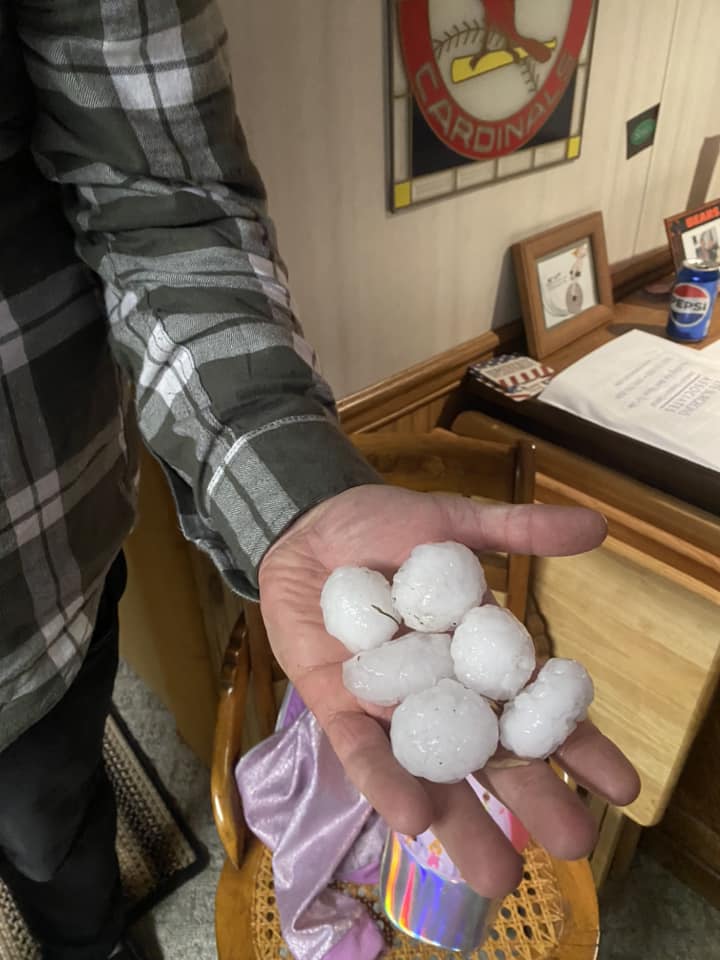
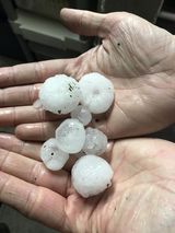
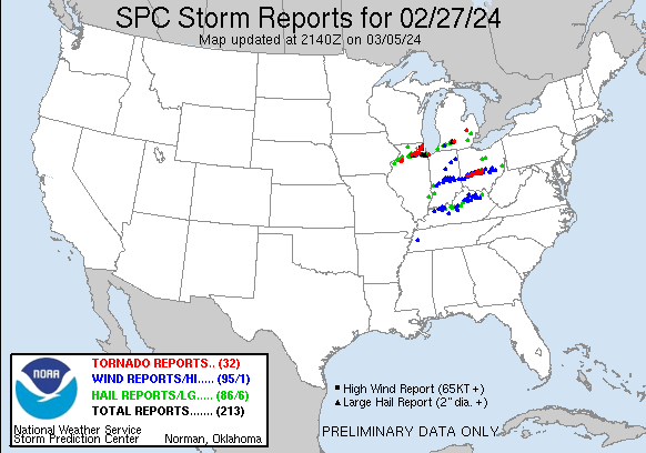
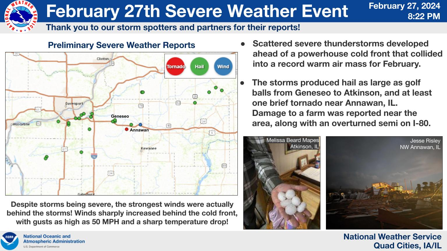
A strong cold front coupled with an anomalously warm air mass (highs in the 70s that broke records for the day, month, and season) and sufficient moisture set the stage for the development of severe thunderstorms across portions of northwest Illinois between 4 PM and 7 PM on Tuesday, February 27. Storms quickly became severe after they developed across northwest Illinois during the late afternoon. As they tracked eastward, they produced hail up the size of golf balls, most notably around the Geneseo, IL and Atkinson, IL vicinities, and one confirmed EF1 tornado in the vicinity of Annawan, IL around 6 PM. A Tornado Warning was issued near 5:30 PM for this storm (NWS headline map at that time). Storms progressed east across northern Illinois during the evening with several more tornadoes in the NWS Chicago County Warning Area. The storms were soon followed by strong non-thunderstorm winds gusting 40-50 MPH with the cold front passage.
Climate Perspective From a climatological perspective, February 27, 2024 was only the third date in February since 1950 there has been a tornado in our CWA. The other dates were Feb 28, 2017 (4 tornadoes) and of course Feb 8, 2024 (1 tornado). |
Warmth Recap (Link to Image) |
Tornadoes
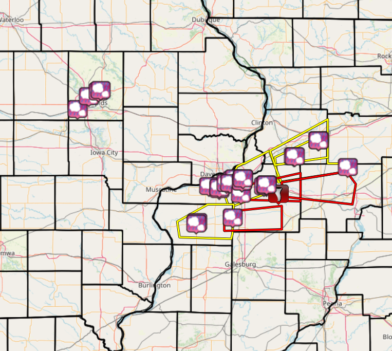
Damage Assessment Toolkit Viewer
|
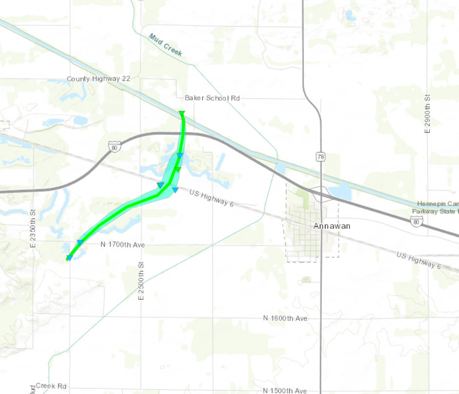
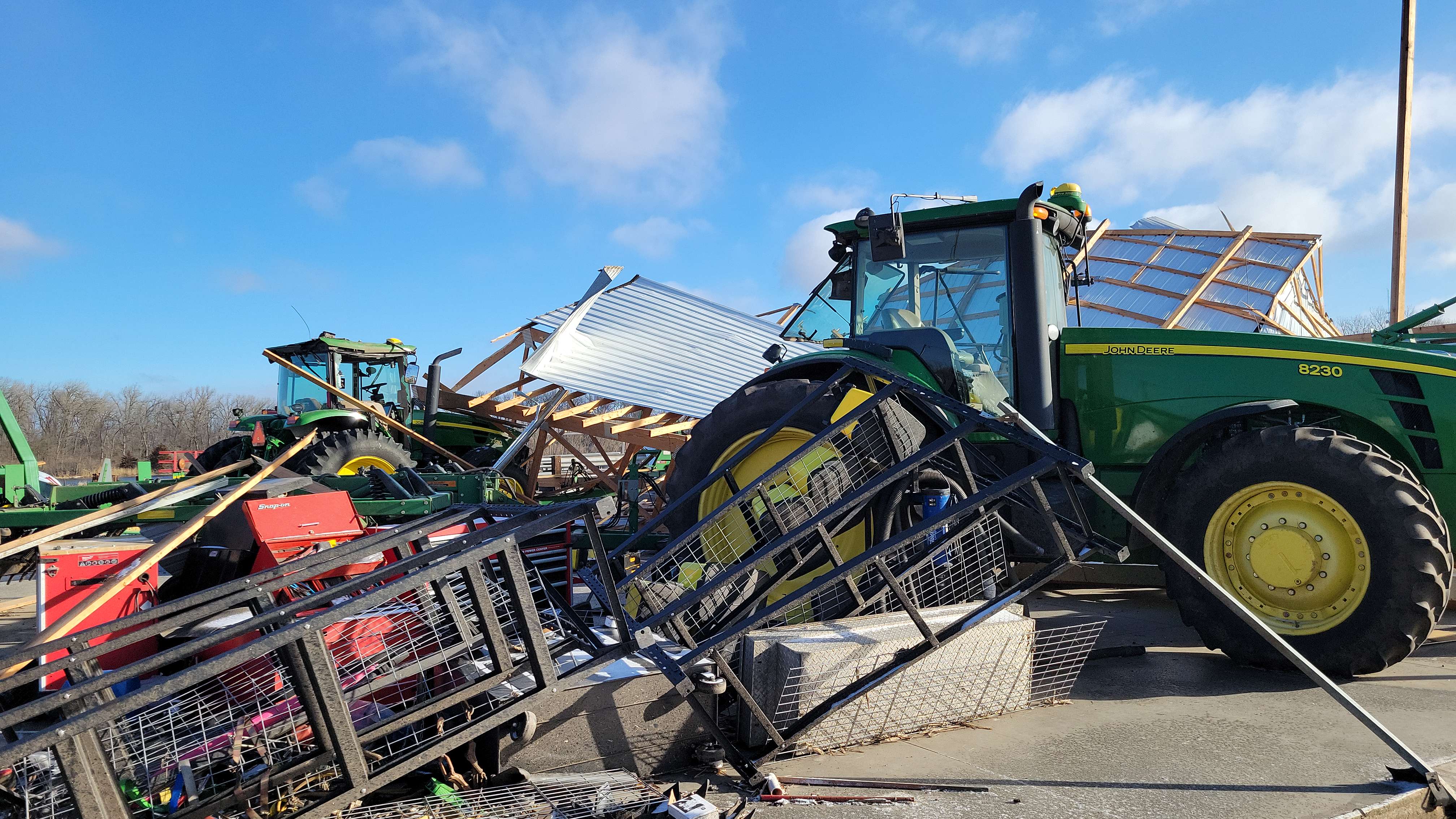
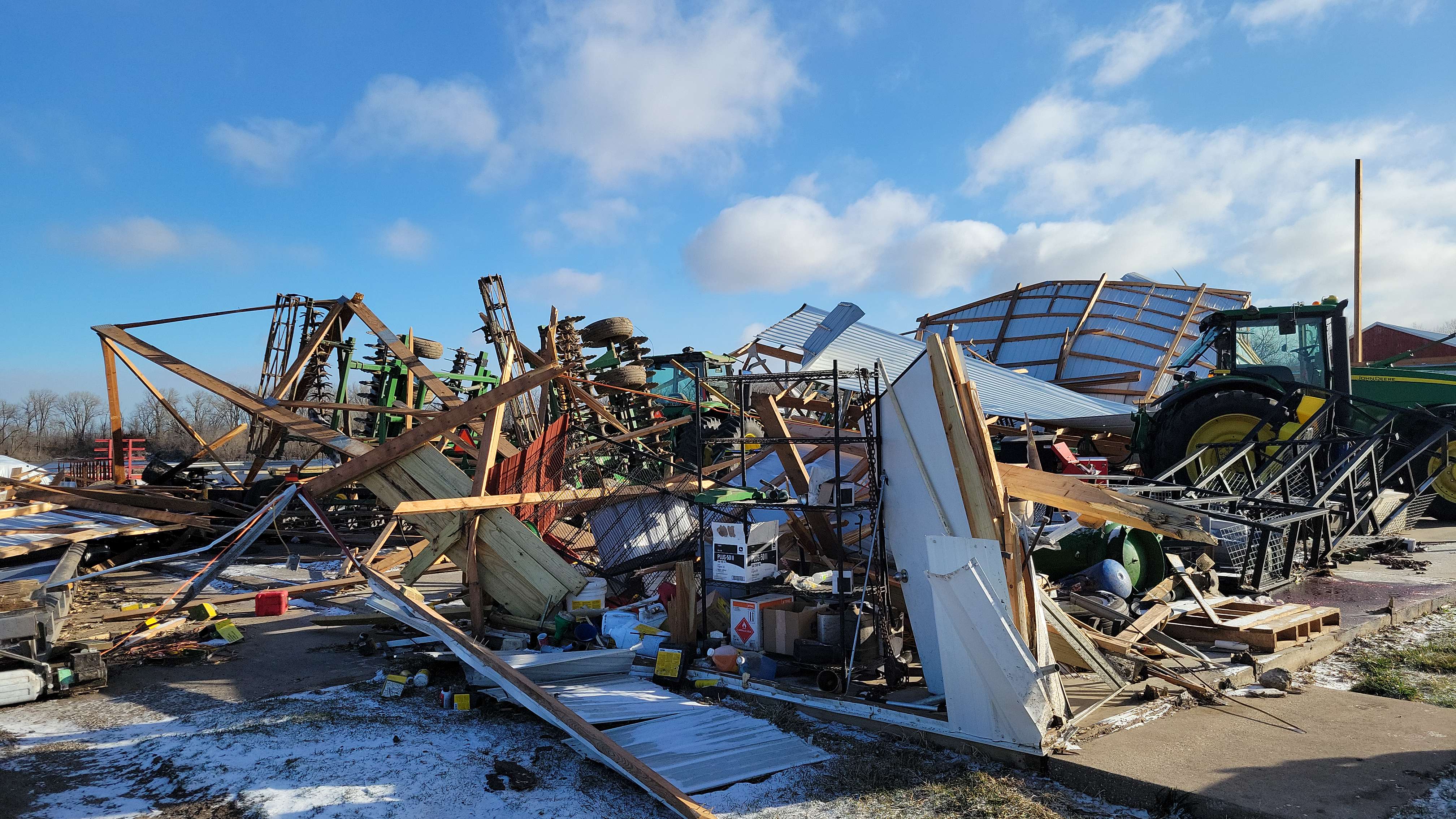
Tornado #1 - Annawan, IL
|
||||||||||||||||
The Enhanced Fujita (EF) Scale classifies tornadoes into the following categories:
| EF0 Weak 65-85 mph |
EF1 Moderate 86-110 mph |
EF2 Significant 111-135 mph |
EF3 Severe 136-165 mph |
EF4 Extreme 166-200 mph |
EF5 Catastrophic 200+ mph |
 |
|||||
Storm Photos
 |
 |
|
|
| Atkinson, IL (Melissa Beard Mapes) | Atkinson, IL (Ashley Littlefield) | Annawan, IL (NWS Storm Survey) | Annawan, IL (NWS Storm Survey) |
Non-Thunderstorm Wind Gusts
Public Information Statement
National Weather Service Quad Cities IA IL
900 AM CST Wed Feb 28 2024

...HIGHEST NON-THUNDERSTORM WIND GUST REPORTS...

Location                     Speed     Time/Date       Lat/Lon
Cedar Rapids Arpt            52 MPH    1023 PM 02/27   41.88N/91.72W
Sigourney                    51 MPH    1230 AM 02/28   41.34N/92.31W
Iowa City Arpt               49 MPH    1027 PM 02/27   41.63N/91.55W
Davenport Arpt               48 MPH    1112 PM 02/27   41.62N/90.58W
Quad City Intl Arpt          48 MPH    1132 PM 02/27   41.45N/90.52W
Anamosa                      48 MPH    1200 AM 02/28   42.07N/91.34W
Us-30 At Us-218              48 MPH    1050 PM 02/27   41.96N/92.03W
Dubuque Arpt                 47 MPH    1203 AM 02/28   42.40N/90.70W
Davenport                    47 MPH    1130 PM 02/27   41.60N/90.68W
Iowa City Us 218             47 MPH    1100 PM 02/27   41.66N/91.60W
Dubuque                      46 MPH    1109 PM 02/27   42.46N/90.77W
Fairfield Arpt               46 MPH    1035 PM 02/27   41.03N/91.97W
Quad Cities                  46 MPH    1030 PM 02/27   41.52N/90.51W
Victor                       46 MPH    1045 PM 02/27   41.70N/92.28W
Burlington Arpt              45 MPH    1224 AM 02/28   40.77N/91.13W
2.5 S Coralville (WEATHERSTE 44 MPH    1050 PM 02/27   41.66N/91.60W
New London                   44 MPH    1130 PM 02/27   40.97N/91.34W
Macomb Arpt                  44 MPH    1055 PM 02/27   40.52N/90.65W
Us-30 Mt Vernon              44 MPH    1030 PM 02/27   41.91N/91.42W
Olin                         43 MPH    1140 PM 02/27   42.02N/91.13W
Eldridge                     43 MPH    1106 PM 02/27   41.64N/90.59W
Washington Arpt              43 MPH    0255 AM 02/28   41.27N/91.67W
Keokuk Arpt                  43 MPH    1115 PM 02/27   40.47N/91.42W
Independence Arpt            43 MPH    1015 PM 02/27   42.45N/91.95W
Sterling/Rock Falls Arpt     43 MPH    0403 AM 02/28   41.75N/89.67W
De Witt                      43 MPH    1130 PM 02/27   41.83N/90.57W
Lamont                       42 MPH    1025 PM 02/27   42.57N/91.69W
Stockton                     41 MPH    0935 PM 02/27   42.40N/89.99W
Riverside                    41 MPH    0257 AM 02/28   41.53N/91.62W
Muscatine Arpt               41 MPH    1035 PM 02/27   41.37N/91.15W
Urbana                       41 MPH    1000 PM 02/27   42.31N/91.98W
Stockton 3 Nne               41 MPH    0800 AM 02/28   42.40N/90.00W
Colesburg                    40 MPH    1030 PM 02/27   42.64N/91.20W
Marion                       40 MPH    1115 PM 02/27   42.05N/91.57W
Stanley                      40 MPH    1215 AM 02/28   42.64N/91.81W
MACOMB                       40 MPH    1039 PM 02/27   40.37N/90.70W
Clinton Arpt                 40 MPH    0148 AM 02/28   41.82N/90.32W
Lowden                       40 MPH    0158 AM 02/28   41.85N/90.90W
Lone Tree (WEATHERSTEM)      39 MPH    0840 PM 02/27   41.49N/91.43W
Fairfax                      39 MPH    1015 PM 02/27   41.90N/91.77W
Fremont                      39 MPH    1025 PM 02/27   41.17N/92.41W
Garrison                     39 MPH    1005 PM 02/27   42.12N/92.16W
Monmouth                     39 MPH    1115 PM 02/27   40.93N/90.63W
Iowa City                    39 MPH    1015 PM 02/27   41.64N/91.51W
Freeport Arpt                39 MPH    0935 PM 02/27   42.25N/89.58W
Urbana                       38 MPH    1100 PM 02/27   42.22N/91.88W
Davenport                    38 MPH    0455 AM 02/28   41.66N/90.48W
Winthrop                     38 MPH    1045 PM 02/27   42.47N/91.73W
Stronghurst                  37 MPH    0226 AM 02/28   40.74N/90.91W
Macomb                       37 MPH    1145 PM 02/27   40.49N/90.69W
Sheffield                    37 MPH    1155 PM 02/27   41.43N/89.69W
Bellevue                     37 MPH    0655 AM 02/28   42.41N/90.56W
Davenport                    37 MPH    0500 AM 02/28   41.63N/90.53W
Aurora                       37 MPH    1100 PM 02/27   42.62N/91.73W
Fort Madison Arpt            37 MPH    1115 PM 02/27   40.67N/91.32W
Mount Pleasant Arpt          37 MPH    0135 AM 02/28   40.95N/91.52W
Savanna Arpt                 37 MPH    0438 AM 02/28   42.05N/90.12W
Manchester                   37 MPH    1035 PM 02/27   42.47N/91.45W
0.6 W Lowden (UPR)           37 MPH    1239 AM 02/28   41.86N/90.93W
Flagstaff Cheshire           36 MPH    1145 PM 02/27   41.59N/90.55W
Iowa City                    36 MPH    0616 AM 02/28   41.65N/91.48W
Garrison                     36 MPH    1035 PM 02/27   42.09N/92.15W
Mount Pleasant               36 MPH    1200 AM 02/28   40.90N/91.56W
Williamsburg                 36 MPH    1035 PM 02/27   41.69N/92.01W
0.7 W Belle Plaine (UPR)     36 MPH    1154 PM 02/27   41.90N/92.29W
Dixon                        35 MPH    1155 PM 02/27   41.69N/90.71W
Wellman                      35 MPH    0955 PM 02/27   41.47N/91.82W
Independence                 35 MPH    1100 PM 02/27   42.47N/91.88W
Independence                 35 MPH    1100 PM 02/27   42.47N/91.89W
Tipton                       35 MPH    1245 AM 02/28   41.64N/91.13W

Observations are collected from a variety of sources with varying
equipment and exposures. We thank all volunteer weather observers
for their dedication. Not all data listed are considered official.
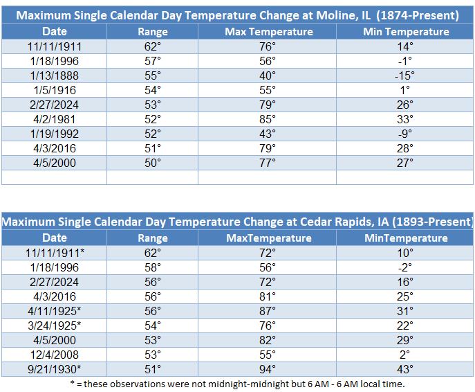
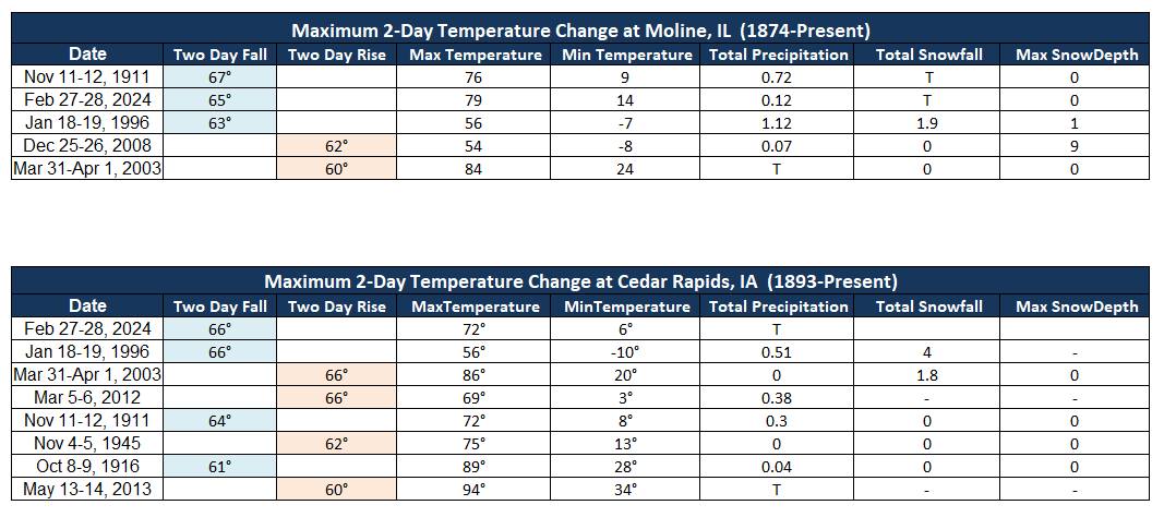
Temperature Drop
After record highs in the 70s, a strong cold front swept through the Midwest in the immediate wake of the severe thunderstorms. This resulted in temperature drops of around 60° in under 18 hours! In how we quantify temperatures (calendar days), this was near a record, and in fact across a two calendar day span for Cedar Rapids it tied the record of 66°.
 |
|
| Largest temperature drops within a single day. | Largest temperature drops that crossed two calendar days. |
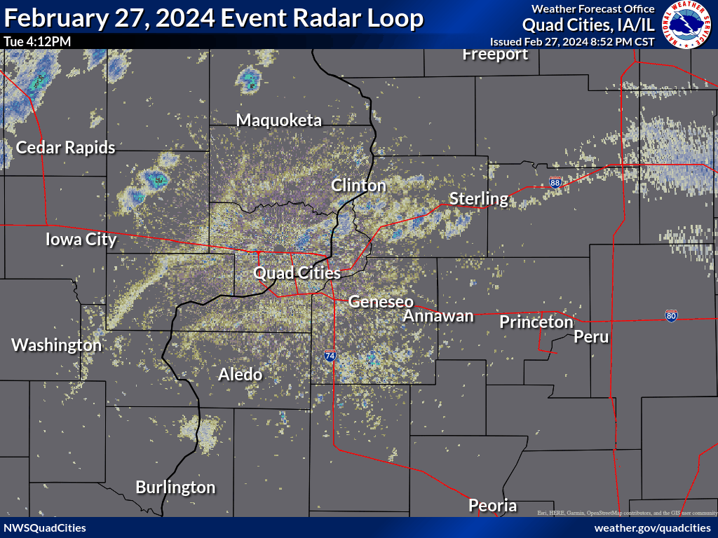
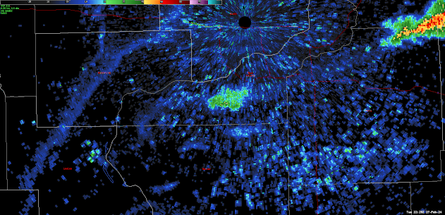
Radar
 |
|
| IEM RADAR LOOP | Storm-following radar loop of the tornadic supercell as it developed and tracked across Henry County, IL |
Storm Reports
| Interactive Storm Report Link | |
 |
|
Preliminary Local Storm Report...Summary National Weather Service Quad Cities IA IL 554 PM CST Wed Feb 28 2024 ..TIME... ...EVENT... ...CITY LOCATION... ...LAT.LON... ..DATE... ....MAG.... ..COUNTY LOCATION..ST.. ...SOURCE.... ..REMARKS.. 0425 PM Hail 1 ENE Fairfax 41.93N 91.76W 02/27/2024 M0.25 inch Linn IA Trained Spotter 0436 PM Hail 3 NNE Cedar Rapids 42.01N 91.66W 02/27/2024 E0.25 inch Linn IA Trained Spotter Occurring right now. 0439 PM Hail 4 WSW Rock Island 41.44N 90.64W 02/27/2024 M0.25 inch Rock Island IL Amateur Radio Delayed report. 0440 PM Hail Marion 42.04N 91.58W 02/27/2024 E0.25 inch Linn IA Public Via social media. 0448 PM Hail 2 ENE Marion 42.05N 91.56W 02/27/2024 E0.25 inch Linn IA Trained Spotter Occurring right now with heavy rain and gusty winds. 0450 PM Hail 1 SE Milan 41.43N 90.55W 02/27/2024 E0.25 inch Rock Island IL Public Via social media. 0450 PM Hail 1 ENE Oak Grove 41.42N 90.55W 02/27/2024 E0.25 inch Rock Island IL Trained Spotter 0500 PM Hail 2 N Leon Corners 41.63N 89.92W 02/27/2024 M1.00 inch Whiteside IL Broadcast Media Delayed report. 0500 PM Hail 1 NE Moline Quad-City A 41.46N 90.49W 02/27/2024 E0.88 inch Rock Island IL Public On I-280 just east of the 5A exit. 0500 PM Hail 2 N Leon Corners 41.63N 89.91W 02/27/2024 E1.00 inch Whiteside IL Public 0501 PM Hail 2 ESE Moline 41.48N 90.46W 02/27/2024 E0.25 inch Rock Island IL Trained Spotter 0504 PM Hail 2 NNE Coal Valley 41.48N 90.44W 02/27/2024 E0.50 inch Rock Island IL Public 0505 PM Hail 1 SSW Silvis 41.49N 90.42W 02/27/2024 M0.50 inch Rock Island IL Trained Spotter Just occurred. 0506 PM Hail 1 NNE Aledo 41.21N 90.74W 02/27/2024 M0.50 inch Mercer IL CO-OP Observer 0506 PM Hail 1 NNW Coal Valley 41.46N 90.46W 02/27/2024 E0.75 inch Rock Island IL Public Report from mPING: Dime (0.75 in.). 0507 PM Hail 2 SSE Warner 41.39N 90.37W 02/27/2024 M0.25 inch Henry IL Trained Spotter Just ended. 0508 PM Hail 1 SSE Green Rock 41.47N 90.36W 02/27/2024 M0.70 inch Henry IL NWS Employee Occurring right now. 0510 PM Hail Aledo 41.20N 90.75W 02/27/2024 M0.88 inch Mercer IL Public Via social media picture. 0510 PM Hail Colona 41.49N 90.35W 02/27/2024 M0.88 inch Henry IL Public Delayed report via social media picture. 0512 PM Hail Colona 41.47N 90.36W 02/27/2024 E1.00 inch Henry IL Broadcast Media Social media picture of quarter size hail relayed by media. 0515 PM Hail Colona 41.49N 90.35W 02/27/2024 E1.00 inch Henry IL Broadcast Media 0523 PM Hail 2 SW Whiteside County A 41.73N 89.71W 02/27/2024 M0.88 inch Whiteside IL Trained Spotter Lasted 5 minutes. 0528 PM Hail 1 NNE Aledo 41.21N 90.74W 02/27/2024 M1.25 inch Mercer IL CO-OP Observer Reported hail ranging between the size of a dollar coin and a half dollar. 0531 PM Hail Ohio 41.56N 89.46W 02/27/2024 M0.70 inch Bureau IL Public Via social media. 0533 PM Hail 2 SW Whiteside County A 41.73N 89.71W 02/27/2024 M0.88 inch Whiteside IL Trained Spotter Lasted 7 minutes. 0538 PM Hail 1 WSW Geneseo 41.44N 90.17W 02/27/2024 E1.75 inch Henry IL Public time estimated from radar. 0540 PM Hail 1 SSE Geneseo 41.44N 90.15W 02/27/2024 E1.25 inch Henry IL Trained Spotter 0541 PM Hail Geneseo 41.45N 90.15W 02/27/2024 M0.25 inch Henry IL Trained Spotter Occurring right now. 0541 PM Hail 2 N New Windsor 41.24N 90.44W 02/27/2024 M0.70 inch Henry IL Trained Spotter Occurring right now. 0545 PM Hail Geneseo 41.45N 90.15W 02/27/2024 E1.25 inch Henry IL Amateur Radio Ham radio relay from a spotter. 0553 PM Funnel Cloud 3 SW Atkinson 41.39N 90.05W 02/27/2024 Henry IL Storm Chaser Corrects previous tornado report from 3 SW Atkinson. Could not find any other corroborating evidence to back up this report. NWS Storm Survey finds tornado starts three minutes later further east. 0556 PM Tornado 2 SE Atkinson 41.39N 89.98W 02/27/2024 Henry IL NWS Storm Survey A high end EF1 tornado formed about 4 miles west of Annawan, IL at 656 PM. The tornado initially caused damage to tree limbs before intensifying as it approached Highway 6. At this point the tornado hit two homesteads causing damaging to siding and shingles at each homestead. One of the homesteads saw a shed destroyed. The tornado reached peak intensity just north of Highway 6, where a well constructed shop was destroyed by the tornado. This damage was rated at 110 MPH winds. The tornado then started to occlude and move more to the left as it crossed I80. A semi was flipped around I80 mile marker 31. A couple of branches were broken on the other side of I80. Around 704 PM, the tornado dissipated just north of I80. The overall path was 2.8 miles and the max width of the tornado was around 425 yards. 0600 PM Hail Atkinson 41.42N 90.01W 02/27/2024 M1.50 inch Henry IL Public Via social media pictures. 0605 PM Hail Atkinson 41.42N 90.01W 02/27/2024 M1.75 inch Henry IL Public Delayed report via social media with pictures. 0607 PM Hail Geneseo 41.45N 90.15W 02/27/2024 E0.25 inch Henry IL Trained Spotter |
|
Rain Reports
| Local 24-hr Rainfall |
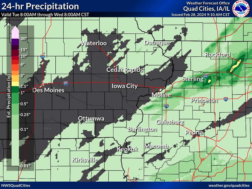 |
24 hour precipitation reports (in Inches),
for eastern Iowa, northwest and west central Illinois,
and northeast Missouri. Reported between Midnight and 9 AM,
Wednesday February 28, 2024.

....IOWA....
Waukon 3N                        0.10
Dubuque 1.4 WNW                  0.03
Mason City 1 NNE                 0.03
Dundee 1.4 NNE                   0.02
Hampton 1 N                      0.02
Keokuk LD19                      0.02
Lowden                           0.02
Robins 0.8 SE                    0.01
Strawberry Point                 0.01
Guttenberg Dam 10                0.01
Mt Pleasant 1 SSW                0.01

....ILLINOIS....
Steward                          1.62
Mundelein                        0.74
Rock Falls 3.1 S                 0.67
Aledo                            0.61
Geneseo 2.0 NW                   0.24
Rochelle Arpt                    0.19
New Windsor 2.0 N                0.14
Altona                           0.13
Ogden                            0.12
Quad City Arpt                   0.12
Windsor                          0.09
Decatur Airport                  0.09
Jacksonville 2E                  0.07
Kewanee 1 E                      0.06
Walnut 5.3 ENE                   0.05
Stronghurst 0.4 SSW              0.04
Lincoln NWS                      0.03
Bloomington Airport              0.03
Viola 0.4 E                      0.02
Winslow 4.3 ESE                  0.02
Stockton 3.4 NNE                 0.02
Gladstone LD18                   0.02
Joliet Arpt                      0.02
Stockton 3 NNE                   0.02
McNabb 1.4 NW                    0.01
Ottawa 4 SW                      0.01
Elizabeth                        0.01

....MISSOURI....
Chillicothe Arpt                 0.06
Kirksville Arpt                  0.04
Kahoka 5.2 ESE                   0.01
Columbia Arpt                    0.01
Memphis                          0.00
....WISCONSIN....
Beloit-College                   0.38
Sullivan-NWS 2 SE                0.12
La Crosse WFO                    0.05
Monroe 1 W                       0.03
Darlington                       0.02
Viroqua                          0.01
Madison Arpt                     0.01
Brodhead 1 SW                    0.01

....MINNESOTA....
Preston                          0.03
Grand Meadow                     0.03
Environment
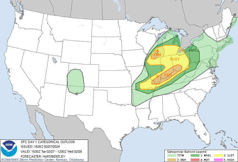
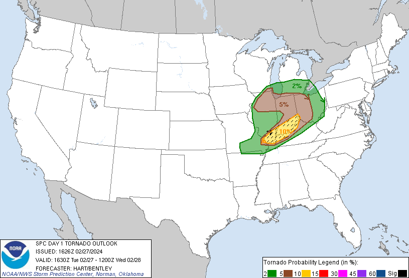
SPC Severe Weather Event Link: February 27, 2024
 |
 |
 |
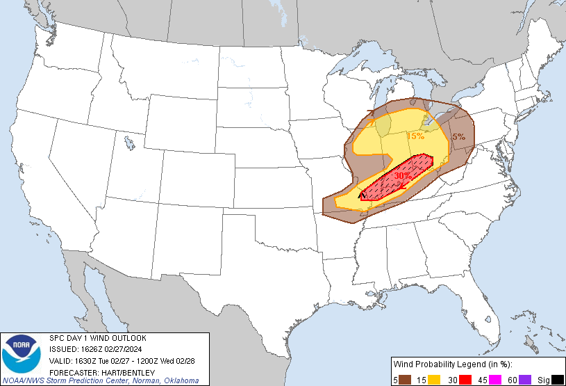 |
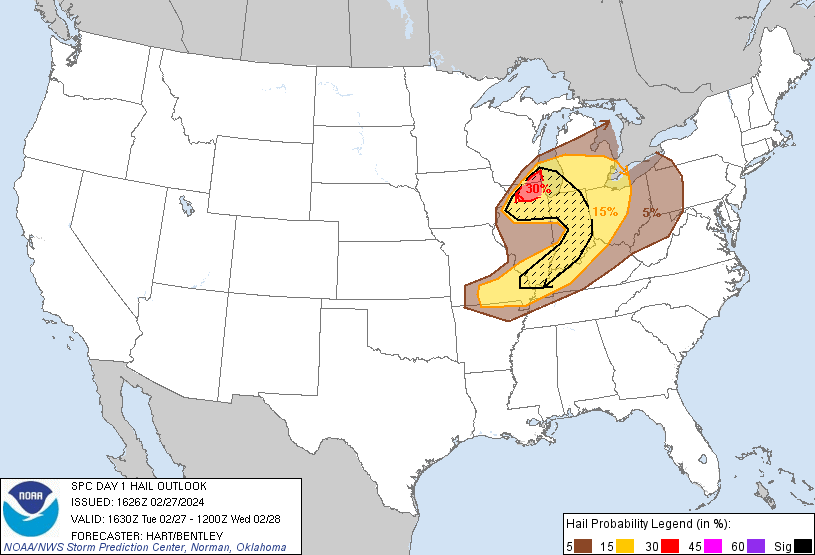
| Figure 1: 13z SPC Day 1 Outlook | Figure 2: 13z SPC Day 1 Tornado Outlook | Figure 3: 13z SPC Day 1 Hail Outlook | Figure 4: SPC Day 1 Wind Outlook |
 |
 |
 |
 |
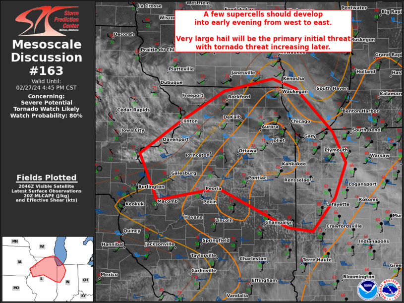
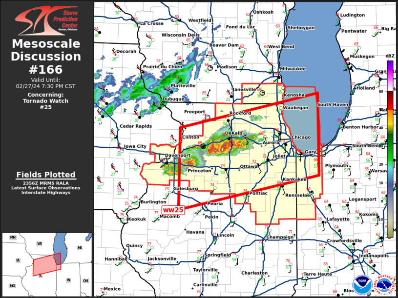
| Figure 5: SPC Mesoscale Discussion 163 | Figure 6: SPC Mesoscale Discussion 166 | Figure 7: 12Z DVN Sounding | Figure 8: 22Z DVN Sounding |
Surface / Satellite Loops / Near-Storm Environment
 |
 |
 |
 |
| Figure 9: Precipitable Water (SPC Mesoscale Analysis) |
Figure 10: Mid-level Lapse Rate (SPC Mesoscale Analysis) |
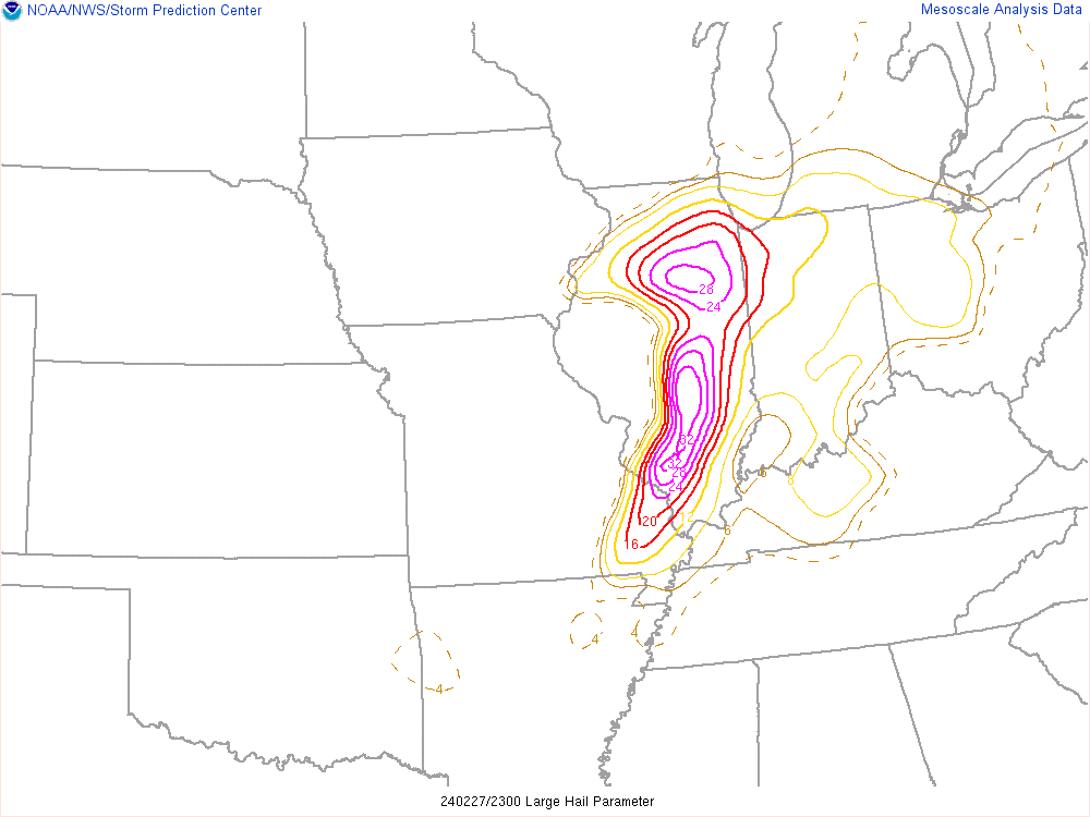
Figure 11: Large Hail Parameter (SPC Mesoscale Analysis) |
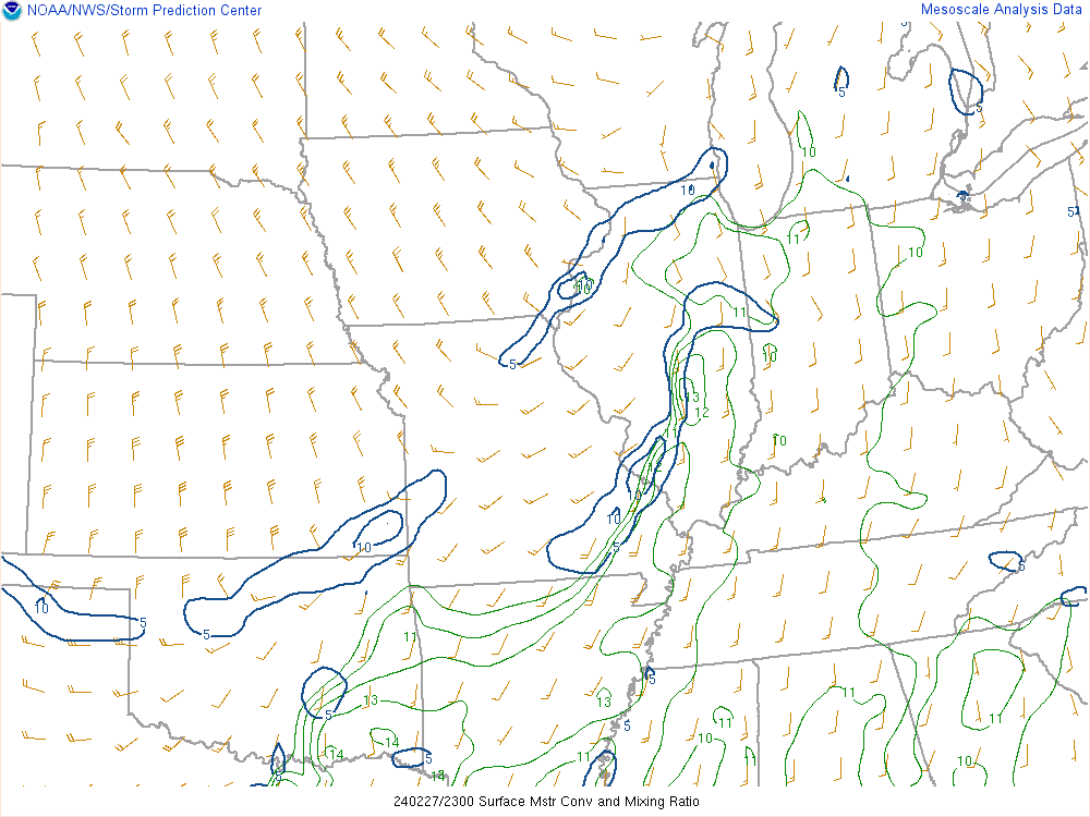
Figure 12: Moisture Convergence (SPC Mesoscale Analysis) |
 |
 |
 |
 |
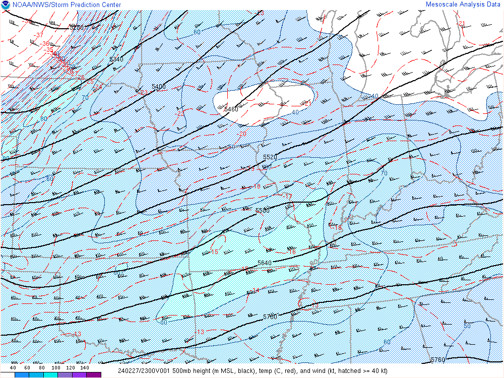
| Figure 13: 500 mb Analysis (SPC Mesoscale Analysis) |
Figure 14: Surface-based CAPE (SPC Mesoscale Analysis) |
Figure 15: 0-6 km Shear (SPC Mesoscale Analysis) |
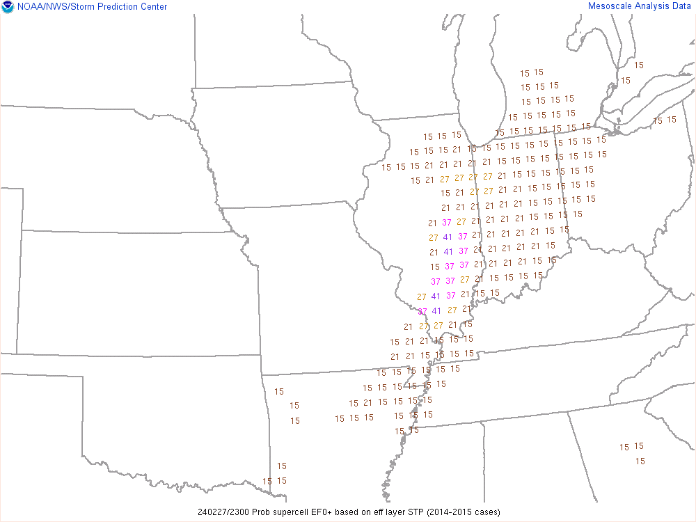
Figure 16: Probability of Supercell (SPC Mesoscale Analysis) |
 |
 |
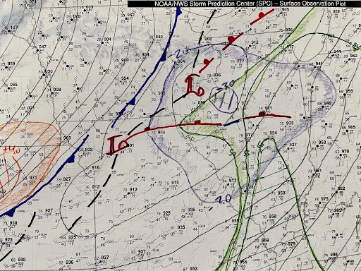 |
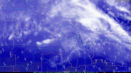
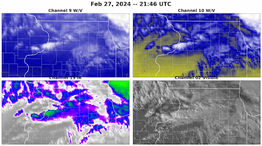
| Figure 17: Satellite Analysis 1 | Figure 18: Satellite Analysis 2 | Figure 19: Hand Analysis 2:00 PM Feb 27 |
 |
Media use of NWS Web News Stories is encouraged! Our past events page can be found at weather.gov/dvn/events. |
|


