Overview
|
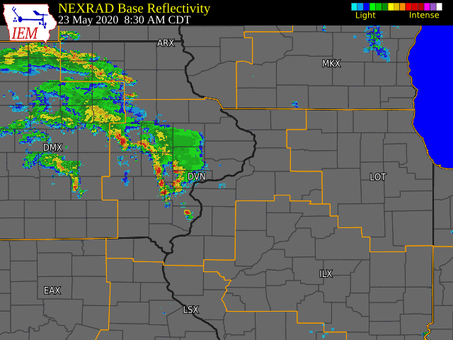
Severe thunderstorms tracked across much of eastern Iowa and northwest Illinois in the early afternoon hours of May 23rd, 2020. Storms quickly intensified in an extremely favorable environment, which was the result of a warm front lifting north across the Midwest. Hazards including tornadoes, torrential rainfall, and large hail. 7 tornadoes were confirmed from this event. Please see the Tornado tab for more details and locations.
Summaries from Other Offices |
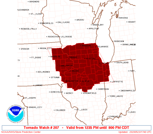 Tornado Watch #207 Graphic |
Tornadoes
|
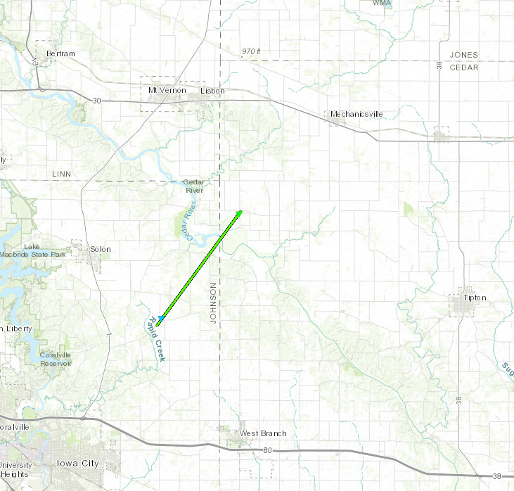
Tornado #1 - 4.3 miles SE Solon, IA
Track Map

|
||||||||||||||||
|
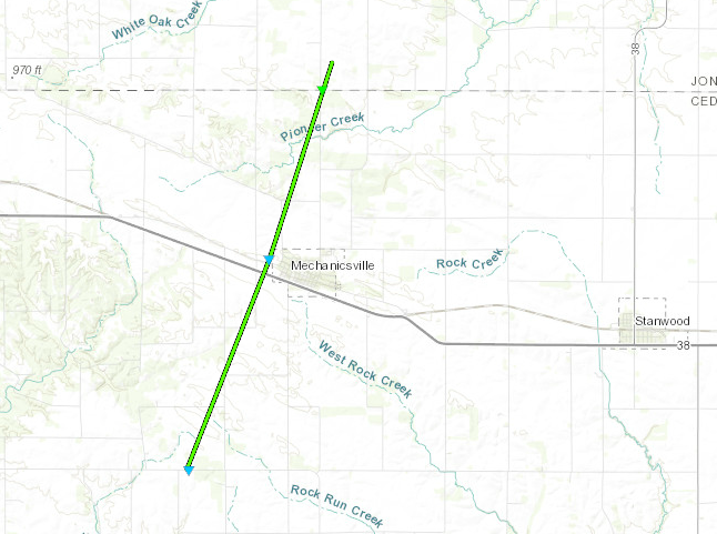
Tornado #2 - Mechanicsville, IA
Track Map
|
||||||||||||||||
|
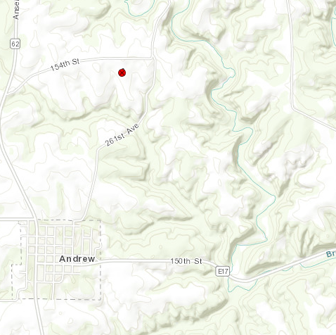
Tornado #3 - 1.2 miles NE Andrew, IA
Track Map
|
||||||||||||||||
|
Tornado #4 - Coleta, IL
Track Map
|
||||||||||||||||
|
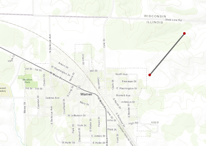
Tornado #5 - Warren, IL
Track Map
|
|||||||||||||||||
|
|||||||||||||||||
|
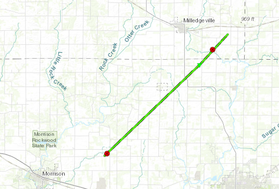
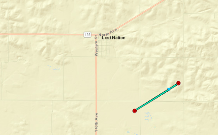
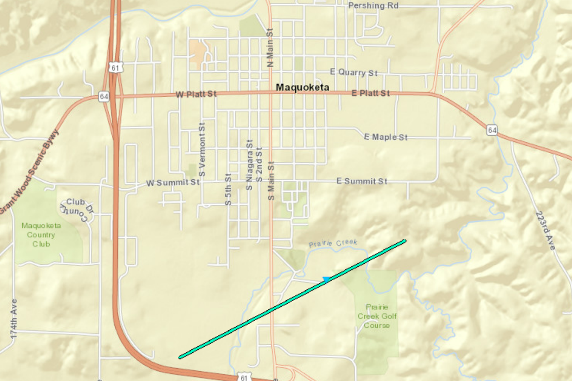
Tornado #7 - 0.5 miles S Maquoketa, IA
Track Map
|
||||||||||||||||
The Enhanced Fujita (EF) Scale classifies tornadoes into the following categories:
| EF0 Weak 65-85 mph |
EF1 Moderate 86-110 mph |
EF2 Significant 111-135 mph |
EF3 Severe 136-165 mph |
EF4 Extreme 166-200 mph |
EF5 Catastrophic 200+ mph |
 |
|||||
Storm Reports
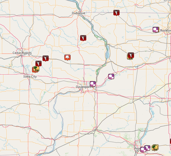
| Interactive Storm Report Map | SPC Storm Reports |
 |
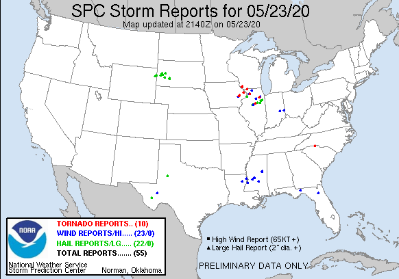 |
PRELIMINARY LOCAL STORM REPORT...SUMMARY
NATIONAL WEATHER SERVICE QUAD CITIES IA IL
514 PM CDT SAT MAY 23 2020

..TIME...   ...EVENT...      ...CITY LOCATION...     ...LAT.LON...
..DATE...   ....MAG....      ..COUNTY LOCATION..ST.. ...SOURCE....
            ..REMARKS..

0502 PM     HEAVY RAIN       3 SW WINNESHIEK         42.32N 89.57W
05/23/2020  M1.50 INCH       STEPHENSON         IL   TRAINED SPOTTER

            RAINFALL TOTAL. STORMS HAVE ENDED.

0500 PM     HEAVY RAIN       3 N STOCKTON            42.40N 90.00W
05/23/2020  M1.69 INCH       JO DAVIESS         IL   CO-OP OBSERVER

            RAINFALL TOTAL TODAY. STORMS HAVE ENDED.

0420 PM     TORNADO          WARREN                  42.50N 89.99W
05/23/2020                   JO DAVIESS         IL   TRAINED SPOTTER

            REPORT OF A TORNADO JUST NORTH OF WARREN BY
            A TRAINED SPOTTER, RELAYED FROM COUNTY 911.

0249 PM     TORNADO          3 SE MILLEDGEVILLE      41.94N 89.73W
05/23/2020                   CARROLL            IL   TRAINED SPOTTER

            BRIEF TORNADO TOUCHDOWN SOUTHEAST OF
            MILLEDGEVILLE, HAS SINCE LIFTED. HAVE HAD
            SEVERAL REPORTS OF BRIEF TOUCHDOWNS.

0247 PM     TSTM WND DMG     3 ENE COLETA            41.92N 89.75W
05/23/2020                   WHITESIDE          IL   FIRE DEPT/RESCUE

            DELAYED REPORT. REPORT OF WIRES DOWN AND
            DAMAGE TO A HOME; SHINGLES OFF THE ROOF.
            POSSIBLE TORNADO DAMAGE. TIME ESTIMATED FROM
            RADAR.

0246 PM     TSTM WND DMG     3 ENE COLETA            41.92N 89.75W
05/23/2020                   WHITESIDE          IL   TRAINED SPOTTER

            POWER LINES DOWN ACROSS ROADWAY. 14 INCH
            TREE DIAMETER TREE SNAPPED. POSSIBLE TORNADO
            DAMAGE. TIME ESTIMATED FROM RADAR.

0225 PM     TORNADO          1 NNE ANDREW            42.17N 90.58W
05/23/2020                   JACKSON            IA   TRAINED SPOTTER

            A TRAINED SPOTTER REPORTED A TORNADO ON THE
            GROUND 1 MILE NORTH NORTHEAST OF ANDREW.

0110 PM     FUNNEL CLOUD     TORONTO                 41.91N 90.86W
05/23/2020                   CLINTON            IA   PUBLIC

            RELAYED BY LAW ENFORCEMENT, ROTATING WALL
            CLOUD WITH FUNNEL. NOT TOUCHING THE GROUND.

0103 PM     HAIL             HAMPTON                 41.56N 90.41W
05/23/2020  M0.50 INCH       ROCK ISLAND        IL   PUBLIC


0103 PM     TORNADO          MECHANICSVILLE          41.90N 91.25W
05/23/2020                   CEDAR              IA   LAW ENFORCEMENT

            RELAYED BY CEDAR RAPIDS WARNING POINT OF
            TORNADO ON THE GROUND AND MOVING NORTH. TIME
            ESTIMATED USING RADAR.

1243 PM     TORNADO          SUTIFF                  41.83N 91.38W
05/23/2020                   JOHNSON            IA   FIRE DEPT/RESCUE

            THE LISBON FIRE CHIEF REPORTED A TORNADO ON
            THE GROUND SOUTH OF SUTLIFF. THERE ARE
            MULTIPLE REPORTS AND PHOTOS FROM THE SAME
            AREA. TIME ESTIMATED BASED ON RADAR.

1238 PM     TSTM WND DMG     1 NE MORSE              41.76N 91.42W
05/23/2020                   JOHNSON            IA   BROADCAST MEDIA

            REPORTED RELAYED FROM BROADCAST MEDIA.
            DAMAGE TO TREES AND FARM OUTBUILDINGS.
            POSSIBLE TORNADO DAMAGE. TIME ESTIMATED FROM
            RADAR.

1230 PM     FUNNEL CLOUD     1 SW MORSE              41.75N 91.44W
05/23/2020                   JOHNSON            IA   TRAINED SPOTTER

            TRAINED SPOTTER ON MORSE RD COULD SEE A
            FUNNEL BUT COULD NOT TELL IF IT WAS ON THE
            GROUND.

1211 PM     HAIL             ERIE                    41.66N 90.08W
05/23/2020  E1.00 INCH       WHITESIDE          IL   TRAINED SPOTTER
Rain Reports
|
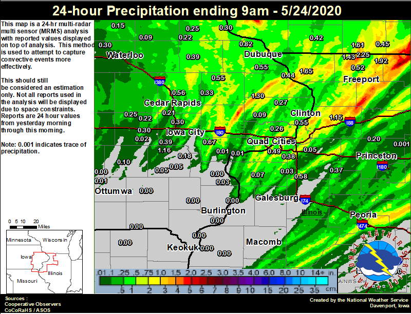
Local Rain Map
|
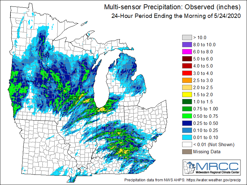
Regional Rain Map (Courtesy of MRCC)
|
24 hour precipitation reports (in Inches), for eastern Iowa, northwest and west central Illinois, and northeast Missouri. Reported between Midnight and 9 AM, Sunday May 24, 2020. ....IOWA.... Maquoketa 4 W 1.30 Dubuque LD11 1.27 Wellman 4.0 E 1.16 Mason City 1 NNE 1.04 Riverdale 0.5 N 0.90 Toledo 3 N 0.82 Rickardsville 0.2 W 0.82 Davenport 0.9 WNW 0.80 Iowa City Arpt 0.77 Fayette 1 NW 0.73 West Liberty 0.7 NNW 0.67 Cedar Rapids 2.7 NE 0.59 Marion 1.7 NNW 0.56 Camanche 1.2 W 0.55 Dubuque Arpt 0.55 Monticello 1 E 0.55 Iowa City 0.53 Dubuque #3 7 SW 0.48 Bellevue LD12 0.44 Newton 1 NE 0.42 Fairfax 4.0 NW 0.40 Mason City ASOS 6 W 0.39 Kalona 7.3 NNW 0.39 Manchester 0.39 Anamosa 3 SSW 0.33 North Liberty 0.7 SSW 0.30 Waterloo ASOS 5 NW 0.30 Guttenberg Dam 10 0.30 Williamsburg 0.30 Davenport Arpt 0.29 Center Point 0.6 NNW 0.28 Asbury 0.4 SW 0.27 Charlotte 1.9 WNW 0.27 Park View 0.2 WSW 0.26 Elkader 6SSW 0.25 Marengo 3.6 N 0.25 Strawberry Point 0.22 Amana 4.7 W 0.22 Cedar Rapids Arpt 5 SW 0.21 Ainsworth 7.4 N 0.18 Eldridge 0.7 SSW 0.17 Marshalltown ASOS 4 N 0.16 Tripoli 0 N 0.15 Sigourney 0.10 Hampton 1 N 0.10 Oelwein AWOS 0.09 Calamus 2.0 NE 0.09 Washington 0.05 Washington 5.8 SW 0.05 NWS Johnston* 5 NNW 0.05 Centerville 0 NE 0.04 Brighton 0.04 Wapello 5.4 SE 0.03 Parnell 0.1 SSW 0.02 Muscatine 2.1 NNW 0.01 Ottumwa ASOS 6 NNW 0.01 Burlington Arpt 2 SW 0.01 Pella AWOS 2 WSW 0.01 Perry 0 W 0.01 Muscatine 2N 0.00 Allerton 2 S 0.00 Rathbun Reservoir 2 N 0.00 Oskaloosa AWOS 9 ESE 0.00 Wapello 0.2 S 0.00 New London 1.5 SW 0.00 Burlington 6.5 SSW 0.00 Burlington 2.1 S 0.00 Keokuk LD19 0.00 Fairfield 0.00 Cantril 0.9 SSE 0.00 ....ILLINOIS.... Orangeville 2.8 NW 2.25 Davis 0.5 N 1.92 Elizabeth 1.65 Freeport 1.44 Winslow 4.3 ESE 1.43 Ridott 0.1 NE 1.16 Morrison 3.2 E 1.15 Mundelein 1.06 Romeoville 0.97 Moline 0.7 NNE 0.71 Woodhull 0.3 ESE 0.58 Freeport 2.0 NW 0.52 Freeport 1.7 NW 0.50 Quad City Arpt 0.49 Coal Valley 1.9 SE 0.38 Kewanee 1 E 0.37 Dakota 4.8 NW 0.34 Coal Valley 2.6 E 0.31 Minonk 0.30 New Boston LD17 0.26 Paw Paw 1 E 0.20 Walnut 5.3 ENE 0.20 Tuscola 0.16 Princeton 1.1 SE 0.15 Princeton 0.15 Peoria ASOS 0.14 Windsor 0.10 Rockford ASOS 0.10 Ogden 0.10 Rochelle AWOS 0.09 Aledo 0.07 Streator 3 SE 0.06 Geneseo 2.0 NW 0.05 Jacksonville AWOS 0.03 New Windsor 2.0 N 0.03 Decatur Airport 0.02 Steward 0.01 Roscoe 2SE 0.01 Ill. City LD16 3 WNW 0.01 Mendota 2 SE 0.00 Bentley 0.00 Galesburg 0.00 Gladstone LD18 0.00 Colchester 3.5 NE 0.00 Joliet 0.00 Nauvoo 0.7 SSE 0.00 Quincy ASOS 0.00 Macomb 0.00 Bloomington Airport 0.00 Galesburg Arpt 3 SW 0.00 Lincoln NWS 0.00 ....MISSOURI.... Columbia 0.00 Memphis 0.00 Chillicothe 2 NW 0.00 Kirksville ASOS 0.00 ....WISCONSIN.... Monroe 1 W 1.61 Beloit-College 1.13 Madison-ASOS 0.80 Prairie du Chien AWOS 0.76 Brodhead 1 SW 0.45 Darlington 0.42 La Crosse WFO 0.40 Whitewater 0.40 Steuben 4SE 3 NE 0.35 Viroqua 0.26 Watertown-AWOS 0.17 Allenton-WWTP .6 NW 0.17 |
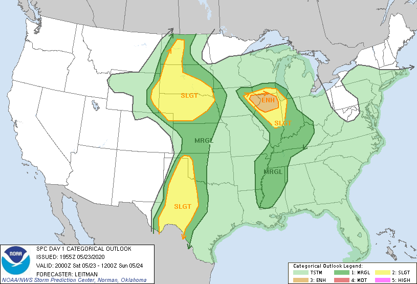
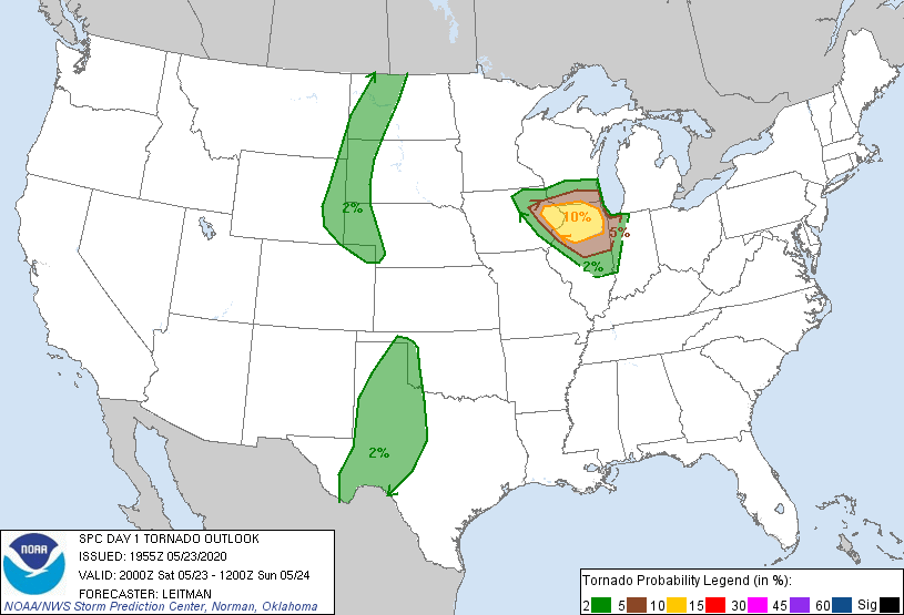
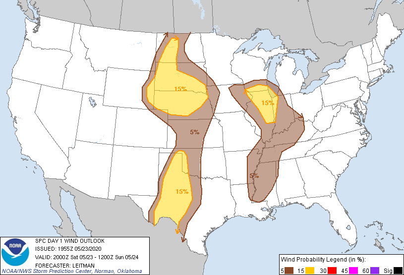
Environment
SPC EVENT REVIEW PAGE: 05/20/2020
 |
 |
 |
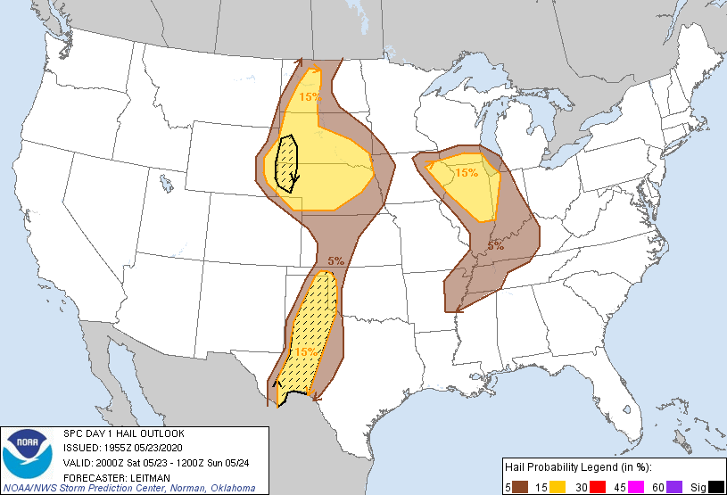 |
| SPC Categorical Outlook | Tornado Outlook | Wind Outlook | Hail Outlook |
 |
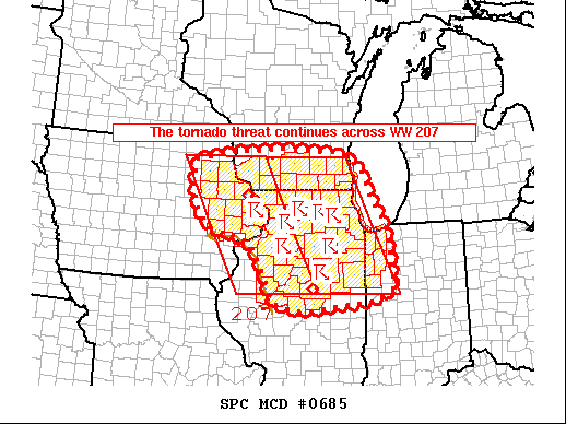 |
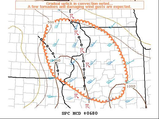
| MCD 680 (text) | MCD 685 (text) |
 |
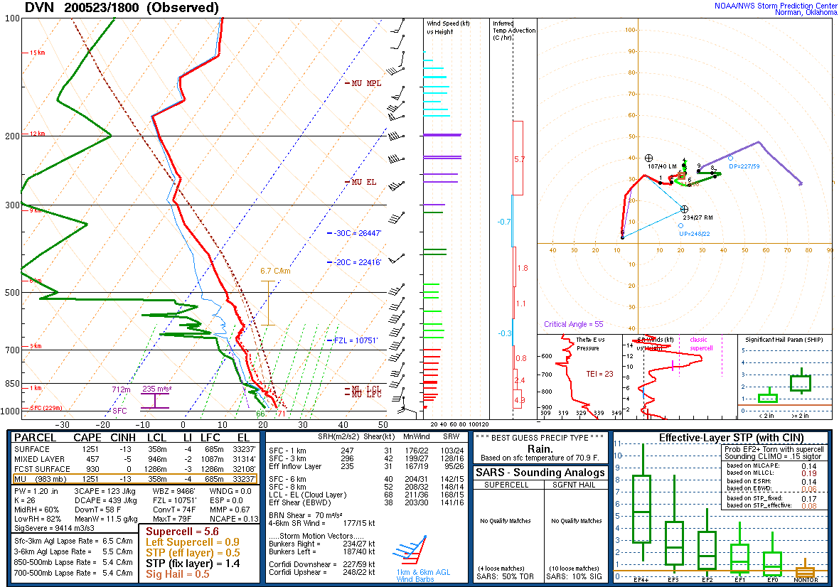 |
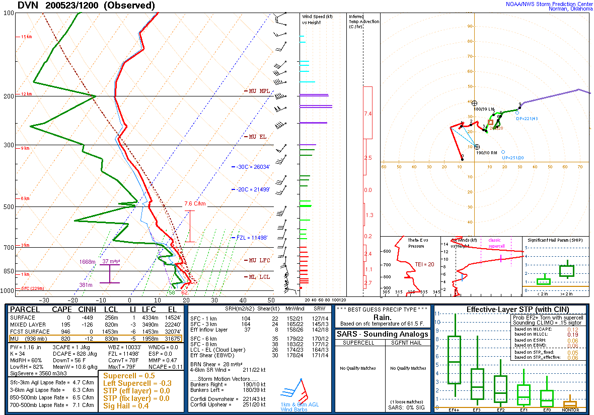
| 7 AM DAVENPORT, IA SOUNDING | 1 PM DAVENPORT, IA |
 |
Media use of NWS Web News Stories is encouraged! Please acknowledge the NWS as the source of any news information accessed from this site. |
|