Numerous severe thunderstorms are expected across a broad region from the Ohio Valley to the Mid-Atlantic and Northeast States today into tonight. Swaths of damaging wind gusts are expected and some tornadoes are possible. Bertha is expected to bring tropical storm conditions to portions of the Gulf Coast from the Florida Panhandle westward to southeastern Louisiana later today and Wednesday. Read More >
Overview
|
Fast Facts:
|
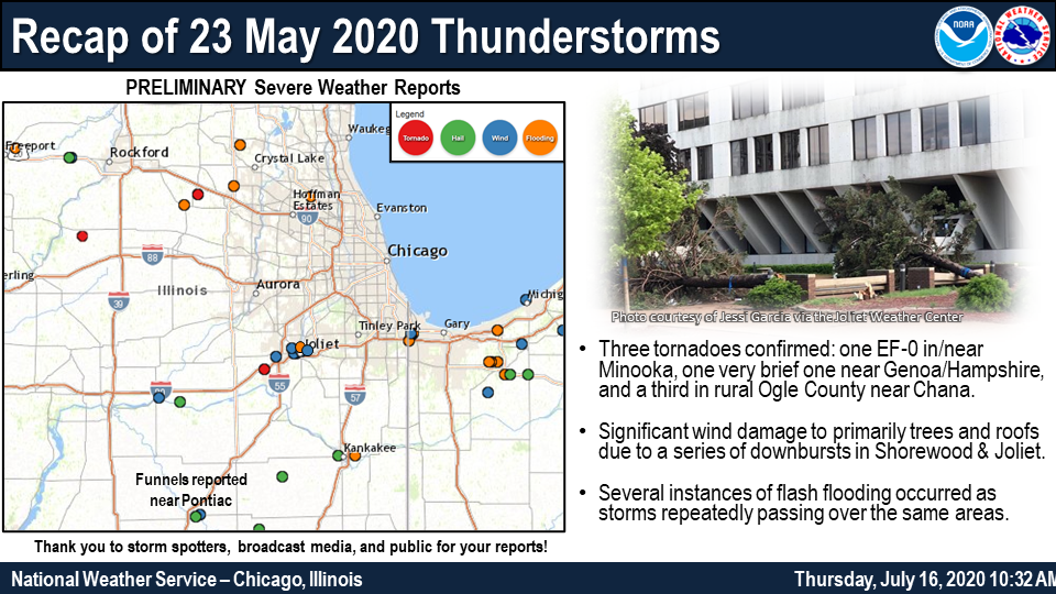 Recap of Severe and Flooding Reports. |
Storm Reports
PRELIMINARY LOCAL STORM REPORT...SUMMARY
NATIONAL WEATHER SERVICE CHICAGO IL
608 PM CDT MON MAY 25 2020
..TIME... ...EVENT... ...CITY LOCATION... ...LAT.LON...
..DATE... ....MAG.... ..COUNTY LOCATION..ST.. ...SOURCE....
..REMARKS..
0205 PM TSTM WND DMG 2 E OTTAWA 41.35N 88.82W
05/23/2020 LA SALLE IL TRAINED SPOTTER
SPOTTER REPORTED NICKEL SIZED HAIL AND
DOWNED TREES ON THE EAST SIDE OF OTTAWA.
TIME ESTIMATED BY RADAR.
0215 PM HAIL MARSEILLES 41.33N 88.71W
05/23/2020 M0.88 INCH LA SALLE IL TRAINED SPOTTER
.
0239 PM HAIL PONTIAC 40.88N 88.63W
05/23/2020 M1.00 INCH LIVINGSTON IL TRAINED SPOTTER
.
0239 PM HAIL PONTIAC 40.88N 88.63W
05/23/2020 M1.75 INCH LIVINGSTON IL TRAINED SPOTTER
0245 PM TSTM WND DMG 1 ENE PONTIAC 40.89N 88.61W
05/23/2020 LIVINGSTON IL 911 CALL CENTER
COUNTY DISPATCH INDICATES SEVERAL CALLS OF
TREES AND POWERLINES DOWN IN AND AROUND THE
PONTIAC AREA. TIME AND LOCATION ESTIMATED
BASED ON RADAR DATA.
0250 PM FUNNEL CLOUD SAUNEMIN 40.89N 88.41W
05/23/2020 LIVINGSTON IL TRAINED SPOTTER
0253 PM TSTM WND GST 2 WNW WINNEBAGO 42.28N 89.28W
05/23/2020 E60 MPH WINNEBAGO IL TRAINED SPOTTER
SPOTTER REPORT OF QUARTER SIZE HAIL AND 60
MPH NW OF WINNEBAGO.
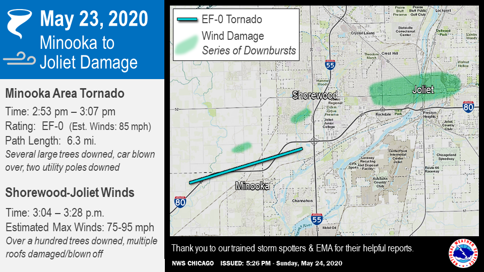
0253 PM TORNADO 1 NW MINOOKA 41.46N 88.27W
05/23/2020 KENDALL IL TRAINED SPOTTER
TRAINED SPOTTER REPORTED A TORNADO LOOKING
NORTH FROM I-80 AND RIDGE RD AND DAMAGE
INDICATES THERE WAS A TORNADO. THIS BEGAN
AROUND 2:53 P.M. AT 41.4535/-88.3269 (3 WNW
OF MINOOKA) AND ENDED AT 41.4800/-88.2106
(2.5 S OF SHOREWOOD). DAMAGE INCLUDED
BLOWING A CAR OVER ON I-80, TWO UTILITY
POLES DOWNED, AND SEVERAL TREES DOWNED OR
DAMAGED. THIS TORNADO STARTED IN GRUNDY
COUNTY, CROSSED INTO KENDALL COUNTY, AND
ENDED IN WILL COUNTY WITH A PATH LENGTH OF
6.3 MILES.
0256 PM HAIL 3 WNW WINNEBAGO 42.28N 89.29W
05/23/2020 E1.00 INCH WINNEBAGO IL TRAINED SPOTTER
0300 PM FUNNEL CLOUD 3 WSW POLO 41.96N 89.63W
05/23/2020 OGLE IL TRAINED SPOTTER
SPOTTER REPORTS AND SOCIAL MEDIA PHOTOS OF
MULTIPLE FUNNEL CLOUDS IN WESTERN OGLE
COUNTY.
0302 PM TORNADO 1 NW MINOOKA 41.46N 88.27W
05/23/2020 GRUNDY IL TRAINED SPOTTER
TRAINED SPOTTER REPORTED A TORNADO LOOKING
NORTH FROM I-80 AND RIDGE RD. BEFORE IT
BECAME RAIN-WRAPPED.
0303 PM TSTM WND DMG 1 SSW SHOREWOOD 41.51N 88.21W
05/23/2020 WILL IL PUBLIC
TREES AND POWERLINES DOWN AT SEIL ROAD NEAR
THE DUPAGE RIVER.
0315 PM TSTM WND DMG 2 SW CREST HILL 41.54N 88.13W
05/23/2020 WILL IL EMERGENCY MNGR
SEVERAL REPORTS OF POWER LINES DOWN ALONG
BLACK RD. AT THE INTERSECTIONS WITH N ANN
ST. AND N LARKIN AVE. TIME ESTIMATED BY
RADAR.
0320 PM TSTM WND DMG 1 NNW ROCKDALE 41.52N 88.12W
05/23/2020 WILL IL BROADCAST MEDIA
NEAR LARKIN AND JEFFERSON. WIDESPREAD TREE
DAMAGE, INCLUDING SOME HEALTHY TREES A FOOT
OR TWO IN DIAMETER, BLOCKING MULTIPLE
STREETS. BETWEEN 3:15 AND 3:25 PM CDT.
0320 PM TSTM WND DMG 1 NNE ROCKDALE 41.52N 88.11W
05/23/2020 WILL IL PUBLIC
REPORTED ALONG PARK DRIVE IN JOLIET. LARGE
TREE LIMBS DOWN. TIME IS ESTIMATED.
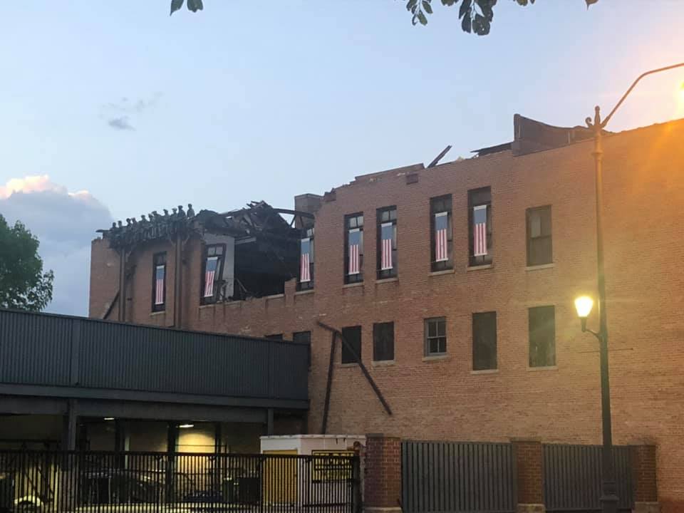
0320 PM TSTM WND DMG JOLIET 41.53N 88.08W
05/23/2020 WILL IL PUBLIC
VIDEO AND PHOTO SHARED ON FACEBOOK OF AN
ENTIRE ROOF BLOWN OFF ONTO JEFFERSON STREET
A BUILDING NEAR THE JOLIET SLAMMERS BALL
PARK. TIME ESTIMATED BASED ON RADAR.
0347 PM HAIL BUCKINGHAM 41.04N 88.18W
05/23/2020 E1.00 INCH KANKAKEE IL LAW ENFORCEMENT
.
0350 PM TSTM WND DMG SOUTH BELOIT 42.49N 89.04W
05/23/2020 WINNEBAGO IL 911 CALL CENTER
WINNEBAGO COUNTY DISPATCH REPORTS WIRES DOWN
ACROSS SOUTH BELOIT. LOCATION ESTIMATED
BASED ON REPORT TIME.
0358 PM HAIL 3 SSW CULLOM 40.83N 88.30W
05/23/2020 E1.00 INCH LIVINGSTON IL TRAINED SPOTTER
0400 PM FLASH FLOOD JOLIET 41.53N 88.09W
05/23/2020 WILL IL PUBLIC
NUMEROUS PHOTOS ON SOCIAL MEDIA SHOWING
STREET FLOODING THROUGHOUT JOLIET.
0425 PM HAIL 2 W KANKAKEE 41.12N 87.89W
05/23/2020 E1.00 INCH KANKAKEE IL TRAINED SPOTTER
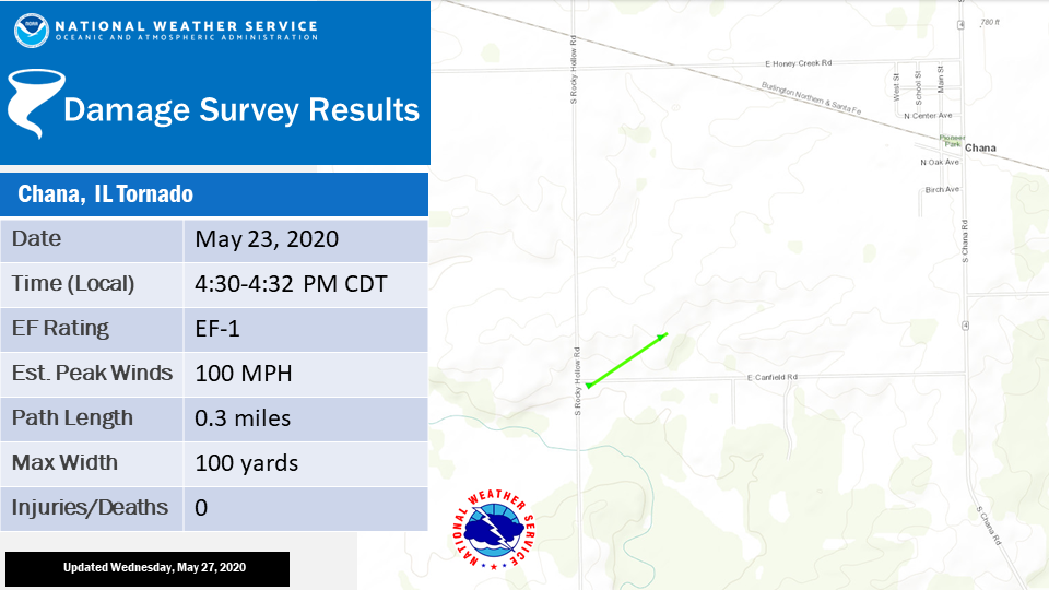
0430 PM TSTM WND DMG 1 SW CHANA 41.97N 89.23W
05/23/2020 OGLE IL EMERGENCY MNGR
BARN HEAVILY DAMAGED. POSSIBLE BRIEF TORNADO
GIVEN FUNNELS IN THE REGION, BUT HAVE NOT
HAD CONFIRMATION. LOCATION OF DAMAGE
RELATIVE TO RADAR ROTATION AND STORM
STRUCTURE INDICATES IT COULD HAVE BEEN
REAR-FLANK DOWNDRAFT WINDS.
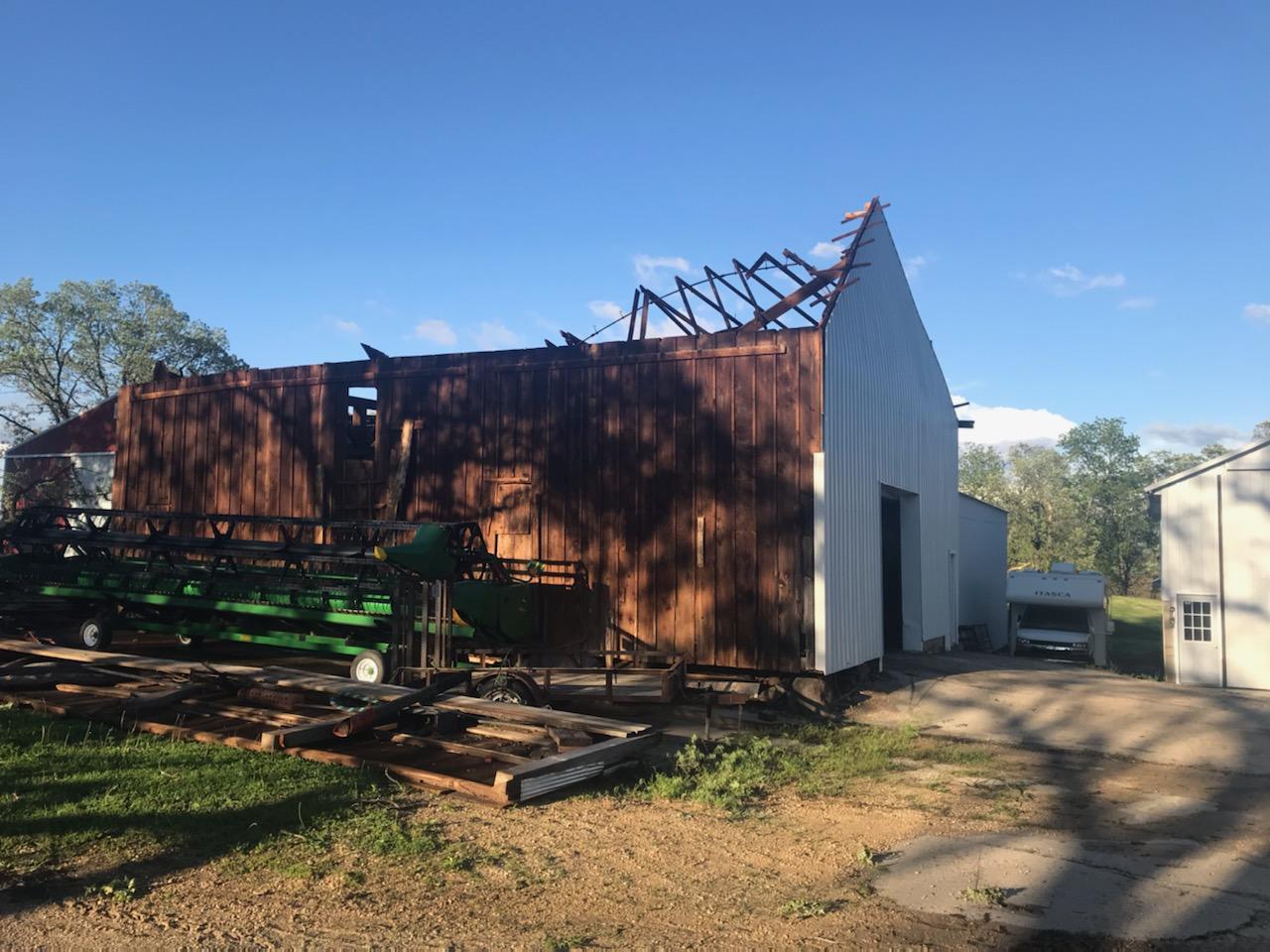
0430 PM TORNADO 1 WSW CHANA 41.97N 89.24W
05/23/2020 OGLE IL NWS STORM SURVEY
EF-1 TORNADO BEGAN AT APPROXIMATELY 430 PM
CDT ON MAY 23RD NEAR THE INTERSECTION OF S.
ROCKY HOLLOW RD. AND E. CANFIELD RD. (41.97,
-89.24). PATH LENGTH OF APPROXIMATELY 0.3
MILES AND ESTIMATED WIDTH OF 100 YARDS. PEAK
WINDS ESTIMATED BETWEEN 90 AND 100 MPH.
OUTBUILDINGS AT TWO FARMSTEADS WERE
SIGNIFICANTLY DAMAGED ALONG WITH SEVERAL
TREES AND POWER POLES. EYEWITNESS ACCOUNTS
AND DAMAGE PHOTOS PROVIDED OGLE COUNTY
EMERGENCY MANAGEMENT PROVIDED KEY SURVEY
INFORMATION.
0431 PM TSTM WND DMG 1 NW HAMMOND 41.59N 87.51W
05/23/2020 LAKE IN PUBLIC
PHOTO OF A COLLAPSED GAS STATION RELAYED BY
MEDIA. TIME ESTIMATED BASED ON RADAR.
0435 PM TSTM WND GST 2 NNW HAMMOND 41.60N 87.51W
05/23/2020 E60 MPH LAKE IN TRAINED SPOTTER
SPOTTER REPORT OF ESTIMATED WIND GUST OF 60
MPH WITH SEVERAL BRANCHES DOWN IN HAMMOND.
ALSO, DIME SIZE COVERING THE GROUND.
0450 PM HEAVY RAIN 1 N HAMMOND 41.60N 87.50W
05/23/2020 M2.00 INCH LAKE IN TRAINED SPOTTER
SPOTTER REPORT OF 2 INCHES OF RAIN FALLING
IN 20 MINUTES IN HAMMOND.
0500 PM HEAVY RAIN 2 NW VALPARAISO 41.49N 87.09W
05/23/2020 M1.00 INCH PORTER IN PUBLIC
RAIN FELL IN 50 MINUTES.
0500 PM HEAVY RAIN LANSING 41.56N 87.54W
05/23/2020 M1.70 INCH COOK IL CO-OP OBSERVER
1.70 INCHES OF RAINFALL OBSERVED BETWEEN
4:15 AND 5:00 PM. STORM TOTAL OF 2.15
INCHES.
0541 PM TSTM WND DMG 8 ESE CHESTERTON 41.56N 86.93W
05/23/2020 PORTER IN PUBLIC
PHOTOS OF SNAPPED TREES AND POWERLINES DOWN.
PHOTOS RELAYED BY MEDIA AND TIME OF DAMAGE
ESTIMATED BASED ON RADAR.
0602 PM HEAVY RAIN 3 N AROMA PARK 41.12N 87.80W
05/23/2020 E1.22 INCH KANKAKEE IL COCORAHS
FLOODING HAS NEVER BEEN THIS BAD. WATER HAS
ERODED A STREAM THROUGH THE FIELD AND IT IS
FLOWING HEAVILY.
0612 PM HEAVY RAIN CHESTERTON 41.61N 87.06W
05/23/2020 E1.60 INCH PORTER IN PUBLIC
RAIN FELL BETWEEN 5:15 AND 6:00 PM.
0612 PM TORNADO 5 NE GENOA 42.14N 88.62W
05/23/2020 DE KALB IL LAW ENFORCEMENT
LIKELY BEGAN NEAR MELMS AND POLK RD. 40 X 20
BARN DAMAGED WITH DEBRIS BLOWN DOWNSTREAM
INTO A FIELD, AND POWER LINES DOWN ABOUT A
MILE DOWNSTREAM. TORNADO WAS LIKELY VERY
SHORT LIVED.
0631 PM HEAVY RAIN 2 WNW VALPARAISO 41.49N 87.10W
05/23/2020 M1.09 INCH PORTER IN COCORAHS
RAIN FELL LAST 40 MINS.
0645 PM FUNNEL CLOUD ALGONQUIN 42.17N 88.29W
05/23/2020 MCHENRY IL PUBLIC
DELAYED REPORT OF A FUNNEL CLOUD NEAR
ALGONQUIN. TIME ESTIMATED BASED ON RADAR.
0645 PM FLASH FLOOD GENOA 42.10N 88.69W
05/23/2020 DE KALB IL LAW ENFORCEMENT
CREEKS OUT OF THEIR BANKS WITH 2 TO 3 FEET
OF WATER OVER SOME ROADWAYS IN TOWN.
0655 PM FLASH FLOOD 1 SW HAMMOND 41.57N 87.52W
05/23/2020 LAKE IN PUBLIC
VIDEO SHARED ON FACEBOOK OF A CAR SUBMERGED
WITH AN ONGOING WATER RESCUE NEAR BROADMOOR
AND MANOR. TIME ESTIMATED BASED ON RADAR AND
TIME OF SHARED VIDEO.
0711 PM HEAVY RAIN 3 SE VALPARAISO 41.44N 87.02W
05/23/2020 M0.78 INCH PORTER IN COCORAHS
RAIN FELL IN 15 MINUTES.
0711 PM FUNNEL CLOUD 1 NE CEDAR LAKE 41.38N 87.42W
05/23/2020 LAKE IN TRAINED SPOTTER
REPORT FROM SOCIAL MEDIA OF FUNNEL CLOUD
SPOTTED NEAR CEDAR LAKE. TIME ESTIMATED BY
RADAR.
0715 PM HEAVY RAIN HUNTLEY 42.17N 88.43W
05/23/2020 M1.93 INCH MCHENRY IL COCORAHS
RAIN FELL IN 45 MINUTES. FOOT OF WATER ON
ROUTE 47 NORTH OF OBSERVERS LOCATION.
0745 PM HEAVY RAIN 1 N VALPARAISO 41.49N 87.06W
05/23/2020 M1.50 INCH PORTER IN COCORAHS
RAIN FELL IN 25 MINUTES.
0748 PM HEAVY RAIN 2 WNW VALPARAISO 41.49N 87.10W
05/23/2020 M2.86 INCH PORTER IN PUBLIC
2.00 INCHES OF RAIN FELL IN 30 MINUTES.
0753 PM TSTM WND DMG 1 NE BOONE GROVE 41.37N 87.11W
05/23/2020 PORTER IN PUBLIC
PHOTOS RELAYED VIA EMAIL OF TREES DOWN IN
THE ROAD. LOCATION BASED ON SHARED GPS
POSITION AND TIME BASED ON RADAR.
0802 PM HAIL 4 SE VALPARAISO 41.44N 86.99W
05/23/2020 E1.00 INCH PORTER IN PUBLIC
REPORT FROM MPING: QUARTER (1.00 IN.).
0830 PM HEAVY RAIN 1 NNE PALATINE 42.13N 88.03W
05/23/2020 M1.58 INCH COOK IL COCORAHS
RAIN FELL IN 45 MINUTES.
0833 PM HEAVY RAIN 2 WNW BULL VALLEY 42.33N 88.40W
05/23/2020 M1.54 INCH MCHENRY IL COCORAHS
RAIN FELL IN 3 HOURS.
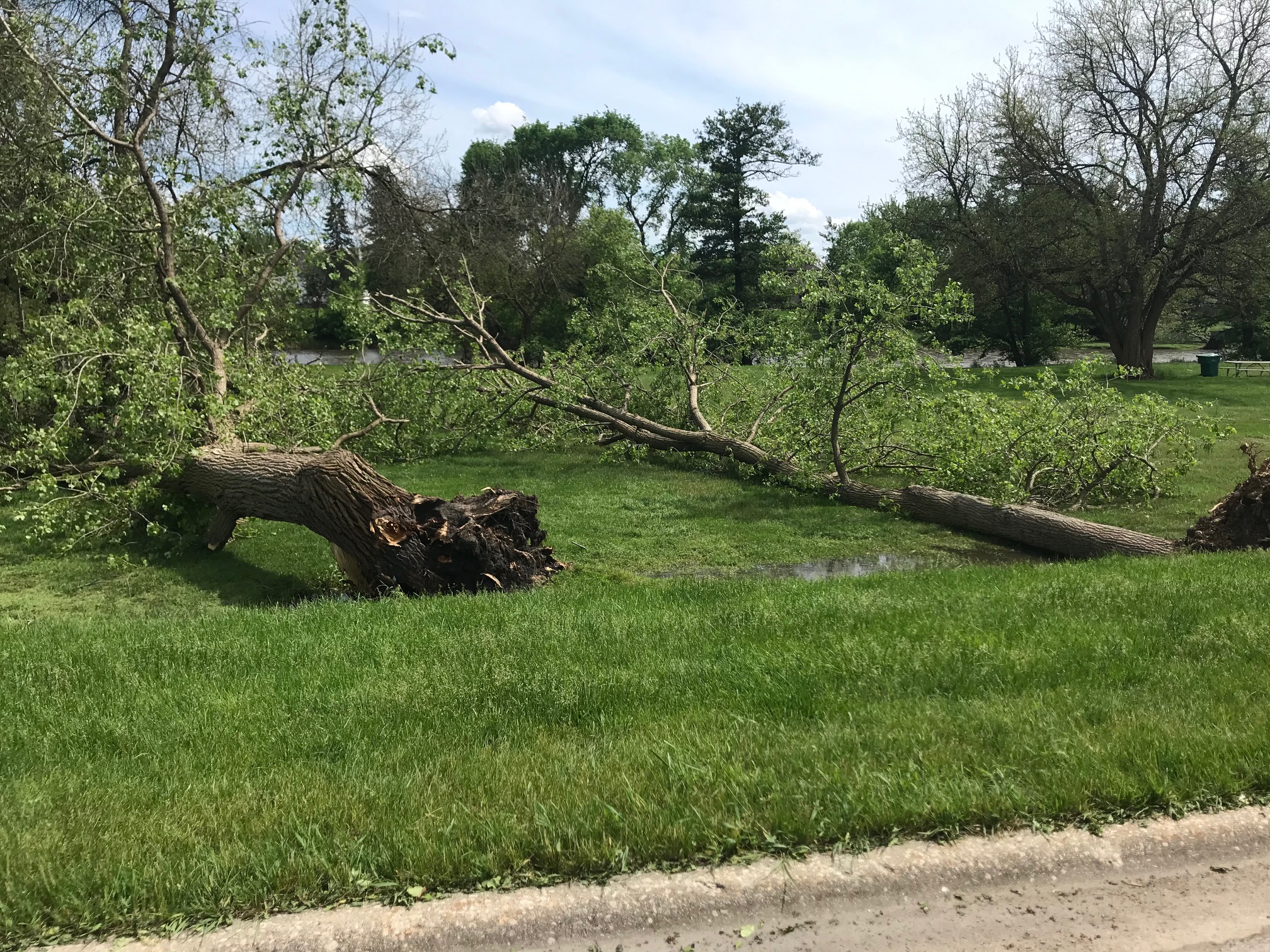
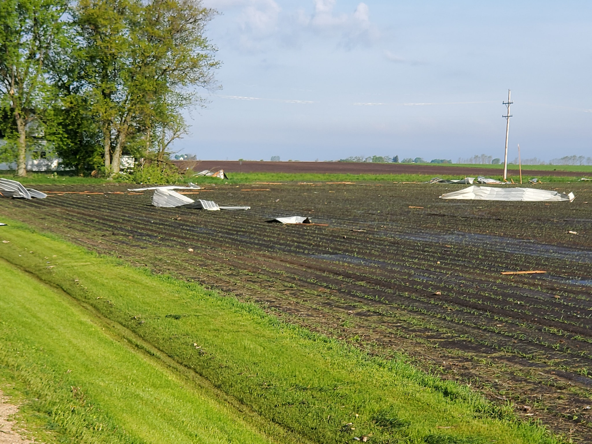
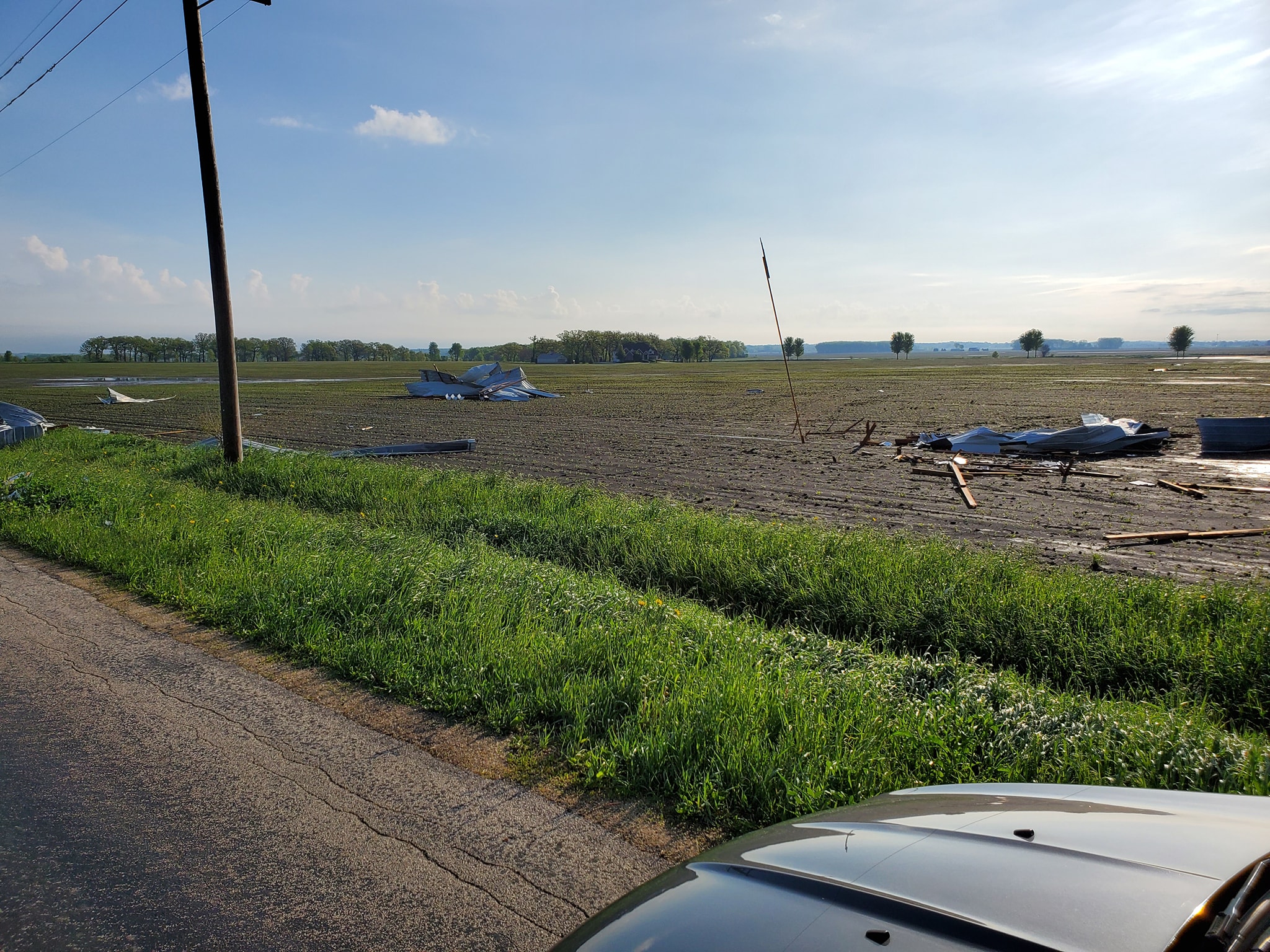
Minooka Tornado and Joliet Damage
|
|
Chana, IL Tornado
 |
 |
 |
 |
| Track Map | Damage near Chana, IL. Image courtesy of Candice King. | Damage near Chana, IL. Image courtesy of Candice King. | Damage near Chana, IL. Image courtesy of Candice King. |
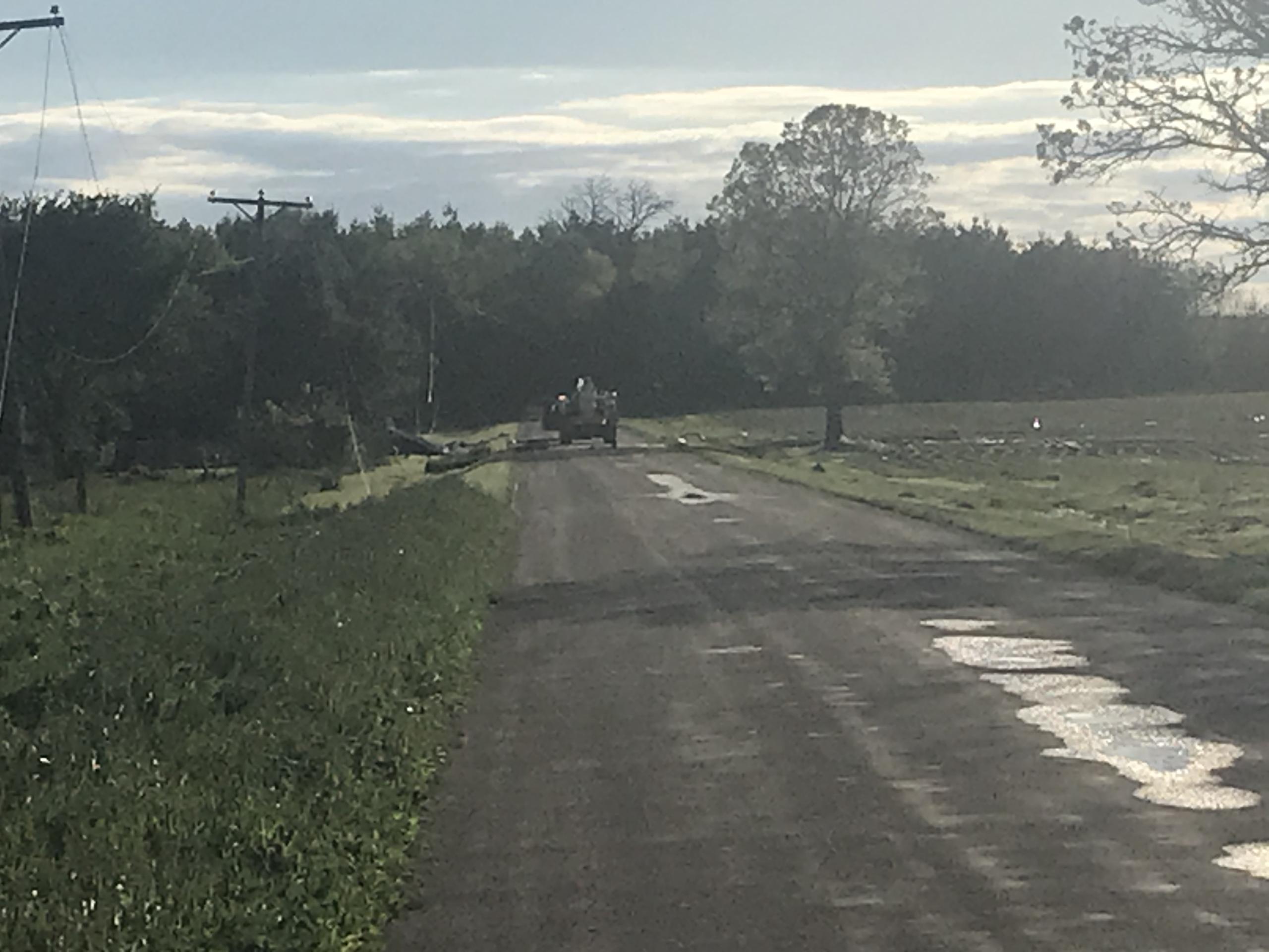
Hamshire/Genoa, IL Tornado
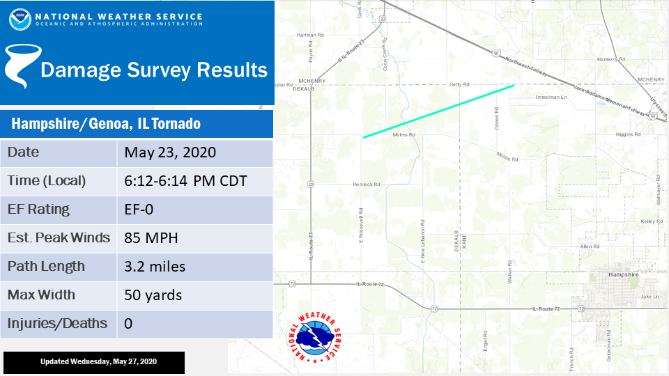 |
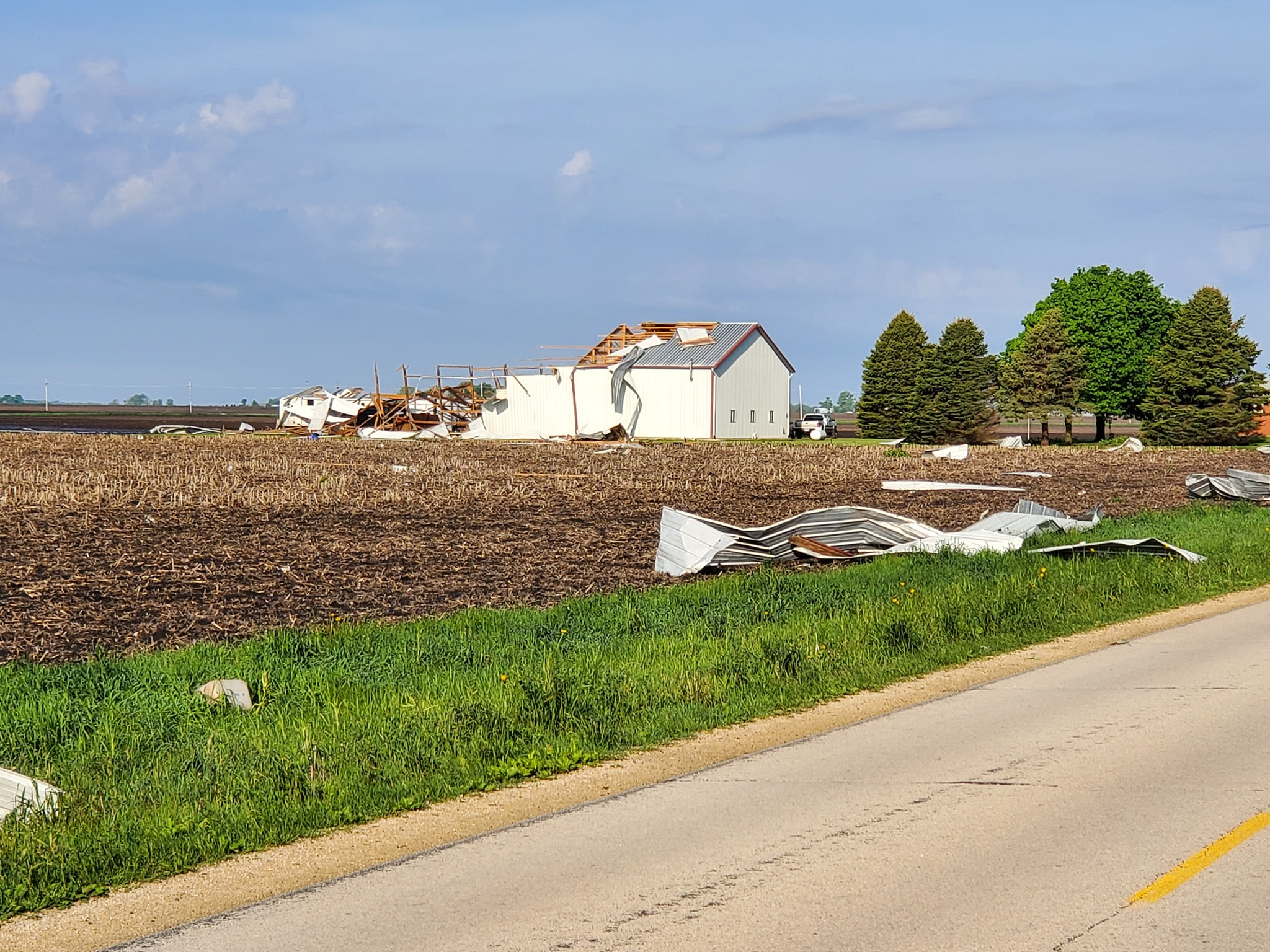 |
 |
 |
| Track Map | Tornado damage near Melms Rd. and Polk Rd. Image courtesy of Larry Brodersen. | Tornado damage near Melms Rd. and Polk Rd. Image courtesy of Larry Brodersen. | Tornado damage near Melms Rd. and Polk Rd. Image courtesy of Larry Brodersen. |
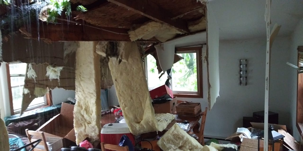
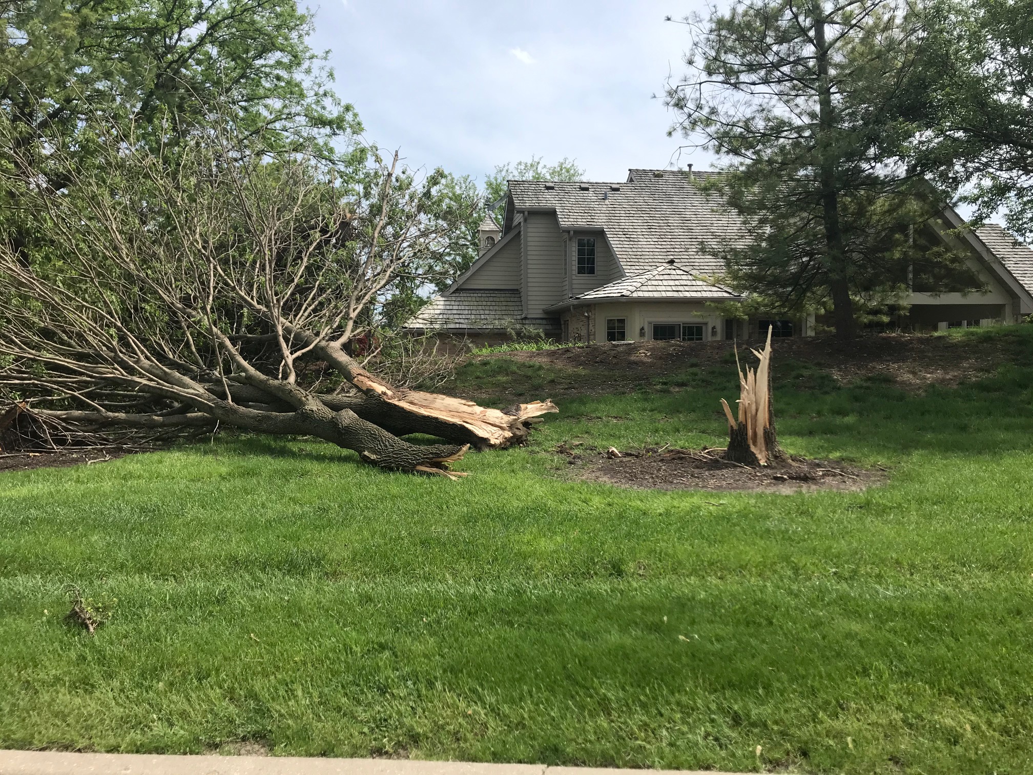
Public Information Statement
National Weather Service Chicago IL
625 PM CDT Sun May 24 2020 /725 PM EDT Sun May 24 2020/

...PRELIMINARY SUMMARY OF THE 5/23/20 SEVERE WEATHER EVENT...

.OVERVIEW...During the afternoon and early evening of Saturday,
May 23, there was scattered severe weather across northern
Illinois and northwest Indiana. Some of the most pronounced
damage was in the far southwest Chicago suburbs occurring in
the mid-afternoon.

.MINOOKA AREA TORNADO...

Rating:                 EF-0
Estimated Peak Wind:    85 mph
Path length /Statute/:  6.3 miles
Path width /Maximum/:   100 yards
Fatalities:             0
Injuries:               1

Start date:             5/23/20
Start time:             2:53 P.M. CDT
Start location:         3 miles west-northwest of Minooka
Start Lat/Lon:          41.4535 / -88.3269

End date:               5/23/20
End time:               3:07 P.M. CDT
End Location:           2.5 miles south of Shorewood
End lat/lon:            41.4800 / -88.2106

SUMMARY: The tornado appeared to develop near I-80 about a
mile west of the Minooka exit. The tornado was likely
responsible for blowing over a car on I-80 resulting in an
injury. The tornado then went on to down at least two wooden
utility poles, about a half dozen large trees, and numerous
large branches. Trained spotter reports helped to further
clarify this was tornado damage. There was also some spotty
wind damage just north of the tornado in a subdivision, and
just south within the town of Minooka.

.CHANA AREA TORNADO...

Rating:                 EF-1
Estimated Peak Wind:    100 mph
Path length /Statute/:  0.3 miles
Path width /Maximum/:   100 yards
Fatalities:             0
Injuries:               0

Start date:             5/23/20
Start time:             4:30 P.M. CDT
Start location:         1 mile southwest of Chana
Start Lat/Lon:          41.97 / -89.24

End date:               5/23/20
End time:               4:32 P.M. CDT
End Location:           1 mile southwest of Chana
End lat/lon:            41.97 / -89.24

SUMMARY: An EF-1 tornado began at approximately 430 PM CDT
on May 23rd near the intersection of S Rocky Hollow Rd. and
E. Canfield Rd. Peak winds were estimated at 90-100 mph
based on damage to outbuildings at two farmsteads that were
significantly damaged. There were also several trees and
power poles downed. Eyewitness accounts and damage photos
provided by Ogle County Emergency Management provided key
survey information.

.HAMPSHIRE/GENOA AREA TORNADO...

Rating:                 EF-0
Estimated Peak Wind:    85 mph
Path length /Statute/:  3.2 miles
Path width /Maximum/:   50 yards
Fatalities:             0
Injuries:               0

Start date:             5/23/20
Start time:             6:06 P.M. CDT
Start location:         4 miles northeast of Genoa
Start Lat/Lon:          42.14 / -88.63

End date:               5/23/20
End time:               6:16 P.M. CDT
End Location:           4 miles north-northwest of Hampshire
End lat/lon:            42.15 / -88.57

SUMMARY: The tornado began near the intersection of Polk Rd
and Melms Rd where a barn was damaged with debris from the
barn blown downstream into a field. The tornado continued
moving east northeast for a little over 3 miles downing
power lines along its path. The tornado dissipated before
reaching I-90.

EF0...Weak......65 to 85 mph
EF1...Weak......86 tO 110 mph
EF2...Strong....111 To 135 mph
EF3...Strong....136 to 165 mph
EF4...Violent...166 To 200 mph
EF5...Violent...>200 mph


.SHOREWOOD THUNDERSTORM DOWNBURST...

Estimated Peak Wind:    75-95 mph
Fatalities:             0
Injuries:               0

Start date:             5/23/20
Start time:             3:04 P.M. CDT

End date:               5/23/20
End time:               3:07 P.M. CDT

SUMMARY: At least two dozen large trees were downed, including
some snapped, in residential Shorewood along and near Seil
Street. This includes large trees down along the DuPage River.
This tree damage was concentrated and intense, with all trees
laying in an easterly direction, evidence for a strong
downburst (microburst).


.JOLIET THUNDERSTORM DOWNBURSTS...

Estimated Peak Wind:    75-95 mph
Fatalities:             0
Injuries:               0

Start date:             5/23/20
Start time:             3:12 P.M. CDT

End date:               5/23/20
End time:               3:28 P.M. CDT

SUMMARY: Many dozen large trees downed across Joliet including
in its downtown. There was also wind damage to multiple roofs
most notably much of the roof lifted off and thrown from a
downtown building. This entire damage area was most likely due
to a series of downbursts given its large footprint, reports
over a fairly lengthy duration, and corroborating radar data as
the organized severe thunderstorms moved through.

NOTE:
The information in this statement is PRELIMINARY and subject to
change pending final review of the event and publication in NWS
Storm Data.

Thank you to our trained storm spotters and Emergency Management
Agency partners for their helpful damage reports.

$$

Friedlein/Bardou
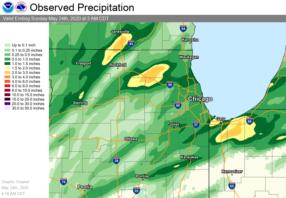
Rain & Flooding
 |
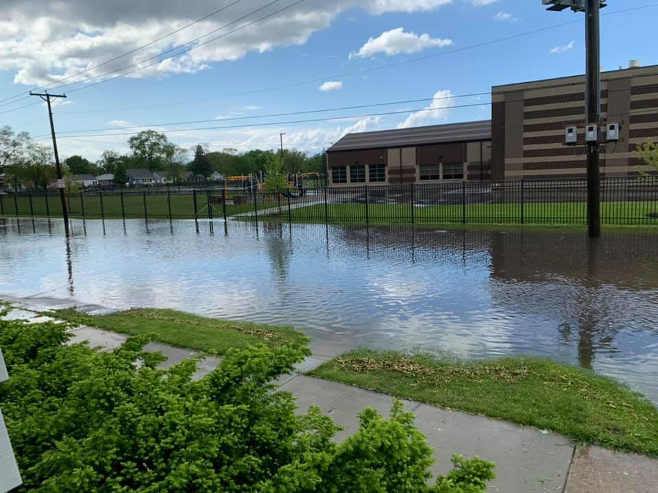 |
| Doppler Radar Estimated Precipitation | Flooding in Lansing. Image courtesy of Jackie Adair. |
Observations are collected from a variety of sources with varying equipment and exposures. We thank all volunteer weather observers for their dedication. Not all data listed are considered official. ...PRECIPITATION REPORTS... Location Amount Provider ...Illinois... ...Boone County... Capron 0.54 in COCORAHS ...Cook County... Lansing 2.15 in COOP Glencoe 1.97 in COCORAHS Barrington 1.75 in COOP Flossmoor 1.70 in URBANET Palatine 1 NNE 1.60 in COCORAHS Lansing Airport 1.48 in AWOS 1 WNW Glenview 1.44 in URBANET Prospect Heights 1 ESE 1.42 in COCORAHS Flossmoor 1 SSW 1.41 in COCORAHS Flossmoor 1 SE 1.39 in COCORAHS Park Forest 1.30 in COOP 1 WSW Northbrook 1.17 in URBANET Park Forest 1 NNE 1.14 in COCORAHS Palatine 1 E 1.12 in COCORAHS Oak Forest 1 NNW 1.06 in COCORAHS Park Forest 1 WNW 1.06 in COCORAHS Medinah 1 N 1.05 in COCORAHS 1.3 NW Calumet City 1.03 in HADS Flossmoor 1.02 in URBANET Homewood 0.99 in COCORAHS Northfield 0.94 in COCORAHS Mount Prospect 1 SSE 0.92 in COCORAHS Park Ridge 1 SSW 0.90 in COCORAHS Elgin 3 ENE 0.88 in COCORAHS Schaumburg 2 E 0.88 in COCORAHS Oak Lawn 0.87 in COCORAHS Chicago Loop 1 NE 0.86 in COCORAHS Palos Park 2 WSW 0.86 in COCORAHS Markham 0.82 in URBANET Park Ridge 1 WNW 0.79 in COCORAHS Chicago - Hyde Park 0.75 in COCORAHS 1 SSW Winnetka 0.75 in URBANET Blue Island 0.74 in URBANET Arlington Heights 1 W 0.73 in COCORAHS Forest Park 1 ESE 0.72 in COCORAHS Chicago 6.3 NW 0.71 in COCORAHS Harwood Heights 0.70 in COCORAHS Elk Grove Village 1 ESE 0.70 in COCORAHS 1 WNW Chicago Heights 0.68 in URBANET Chicago Ridge 0.68 in COCORAHS Forest Park 1 ENE 0.68 in COCORAHS Oak Lawn 0.66 in URBANET Oak Lawn 0.65 in URBANET 1 SW Albany Park 0.64 in URBANET Golf 1 WSW 0.64 in COCORAHS Chicago - Albany Park 0.63 in COCORAHS La Grange Park 1 SSW 0.63 in COCORAHS 1 NW Douglas Park 0.62 in URBANET Glenview 0.62 in URBANET Chicago - West Ridge 0.61 in COCORAHS Arlington Heights 1 W 0.61 in COCORAHS 1 NNW Navy Pier 0.60 in URBANET 1 E Albany Park 0.57 in URBANET Alsip 2 NNE 0.57 in COCORAHS Chicago - Rogers Park 0.57 in COCORAHS Arlington Heights 1 SW 0.57 in COCORAHS Evanston 1 E 0.57 in COCORAHS 1 N Jefferson Park 0.56 in URBANET Wilmette 0.56 in URBANET Evanston 1 SSW 0.55 in COCORAHS Lyons 0.54 in URBANET Evanston 0.53 in COCORAHS Chicago - West Ridge 0.53 in COCORAHS Chicago O``Hare 0.52 in ASOS Midway 3 SW COOP 0.52 in COOP Midway 3 SW 0.52 in COOP Palos Heights 0.52 in URBANET 2 S Jefferson Park 0.51 in URBANET 2 NW Lakeview 0.50 in URBANET Burbank 1 SSW 0.50 in COCORAHS Chicago - Lincoln Park 0.50 in COCORAHS Sauk Village 0.50 in URBANET Albany Park 0.49 in URBANET 1 SSE Chicago Loop 0.49 in URBANET Bridgeview 1 WNW 0.48 in COCORAHS Evergreen Park 0.46 in URBANET 1 WNW Merrionette Park 0.44 in URBANET Alsip 0.43 in URBANET Lakeview 0.43 in URBANET River Grove 0.43 in URBANET Albany Park 0.42 in URBANET Lincoln Park 0.42 in URBANET Hickory Hills 0.42 in URBANET Countryside 1 ENE 0.41 in COCORAHS Rogers Park 0.38 in URBANET Chicago - Albany Park 0.37 in COCORAHS Midway Airport 0.35 in URBANET Brighton Park - Chicago 0.34 in URBANET 1 NNW Midway Airport 0.34 in URBANET Chicago Midway 0.34 in ASOS Lakeview 0.32 in URBANET 1 WNW Logan Square 0.30 in URBANET Hillside 0.30 in URBANET Oak Lawn 1 WSW 0.30 in COCORAHS Hoffman Estates 0.6 ESE 0.25 in COCORAHS Oak Park 1 NNE 0.25 in COCORAHS Hoffman Estates 0.18 in COCORAHS Wheeling - Chicago Exec. Arp 0.16 in ASOS Westchester 0.16 in URBANET ...De Kalb County... Genoa 1.70 in COOP Kingston 2 WNW 1.59 in COCORAHS 5 NNE Shabbona (NIU Agronomy 0.47 in HADS DeKalb 0.28 in COCORAHS DeKalb 0.26 in COCORAHS DeKalb Airport 0.08 in AWOS Somonauk 2 NE 0.02 in COCORAHS Earlville 5 NNE 0.02 in COCORAHS Cortland 0.01 in COCORAHS ...DuPage County... Wheaton 1 NNW 1.65 in COCORAHS Glen Ellyn 1 W 1.52 in COCORAHS Medinah 1.00 in COCORAHS Aurora 4 ESE 0.89 in COCORAHS Glen Ellyn 1 SW 0.84 in COCORAHS Warrenville 0.77 in COCORAHS Aurora 4 ESE 0.69 in COCORAHS Bloomingdale 1 SSE 0.53 in COCORAHS Hillside 1 W 0.52 in COCORAHS Glen Ellyn 2 SSE 0.52 in COCORAHS Naperville 1 W 0.52 in COCORAHS Willow Springs 2 SE 0.50 in COOP 2 SSW Burr Ridge 0.48 in URBANET Glen Ellyn 1 SW 0.48 in COCORAHS Elmhurst 1 SE 0.43 in COCORAHS Lombard 0.41 in COCORAHS Darien 2 SE 0.41 in COCORAHS Downers Grove 1 NNW 0.39 in COCORAHS 1 SSE Elmhurst 0.38 in URBANET Lombard 1 NW 0.38 in COCORAHS Woodridge 2 S 0.37 in COCORAHS 1 SSW Lombard 0.36 in URBANET Clarendon Hills 0.36 in UCOOP Lombard 0.34 in COCORAHS Elmhurst 1 SW 0.32 in COCORAHS York Center 0.29 in URBANET Naperville 0.27 in COCORAHS 1.4 SW Woodridge 0.27 in ALERT Schaumburg Airport 0.22 in AWOS 1 S Darien 0.20 in COCORAHS Lisle 1 SSE 0.20 in COCORAHS Bartlett 1.4 SE 0.18 in COCORAHS Lisle 2 SW 0.18 in COCORAHS Naperville 0.02 in UCOOP West Chicago - DuPage Arpt. 0.01 in ASOS ...Ford County... Gibson City 3 WNW 0.71 in COCORAHS Melvin 4 WSW 0.25 in COCORAHS ...Grundy County... Lisbon 4 S 1.55 in COCORAHS Minooka 1.16 in COCORAHS Lisbon 5 S 0.95 in COCORAHS Carbon Hill 3 NNW 0.84 in COCORAHS Illinois R. - Dresden Lock-D 0.82 in HADS Morris Airport 0.79 in AWOS Carbon Hill 3 NW 0.78 in COCORAHS Morris 1 NW 0.65 in COOP Coal City 4 NNW 0.61 in UCOOP Carbon Hill 3 N 0.61 in COCORAHS Morris 2 W 0.44 in COCORAHS Dwight 4 NNW 0.42 in COCORAHS Carbon Hill 3 NE 0.40 in COCORAHS Morris 2 SSE 0.32 in COCORAHS Morris - Illinois R. 0.22 in HADS ...Iroquois County... Buckley 0.42 in COCORAHS Chebanse 2 WSW 0.05 in COCORAHS ...Kane County... 1 NE Gilberts 1.68 in COCORAHS Sleepy Hollow 1 W 1.46 in COCORAHS Elgin 1.05 in COOP 1.9 N Elgin 1.01 in ALERT Elgin 3 W 1.00 in COCORAHS Elgin 3 WNW 0.74 in COCORAHS Aurora 0.50 in COOP Lily Lake 4 NE 0.48 in COCORAHS Elgin 0.44 in UCOOP Elgin 1 SSW 0.44 in COCORAHS North Aurora 1 ENE 0.35 in COCORAHS Aurora 2 W 0.27 in COCORAHS Aurora 3 WSW 0.25 in COCORAHS Kaneville 3 NNW 0.21 in COCORAHS Maple Park 0.17 in COCORAHS Batavia 0.15 in UCOOP Campton Hills 3 NNE 0.12 in COCORAHS Elburn 0.12 in COCORAHS St. Charles 1 ENE 0.10 in COCORAHS St. Charles 1 SSW 0.07 in COCORAHS Batavia 1 NW 0.07 in COCORAHS Batavia 1 NNW 0.06 in COCORAHS Batavia 1 NW 0.05 in COCORAHS Batavia 4 W 0.04 in COCORAHS Batavia 1 NNW 0.04 in COCORAHS Sugar Grove 1 NNE 0.02 in COCORAHS Geneva 2 WNW 0.01 in COCORAHS Sugar Grove 1 NNW 0.01 in COCORAHS Sugar Grove - Aurora Arpt. 0.01 in ASOS ...Kankakee County... Irwin 3 W 1.29 in COCORAHS Momence 5 ENE 0.99 in COOP Bourbonnais 0.30 in COOP Chebanse 0.05 in COCORAHS ...Kendall County... Oswego 1 SSE 1.01 in COCORAHS Plainfield 4 SW 0.73 in COCORAHS Boulder Hill 1 NNE 0.43 in COCORAHS Bristol 0.22 in COCORAHS Oswego 3 NW 0.13 in COCORAHS ...La Salle County... Marseilles 2 WSW 0.61 in COCORAHS Ottawa 1 N 0.43 in COCORAHS Ottawa - Illinois R. 0.34 in HADS Ottawa 0.32 in COCORAHS Starved Rock - Illinois R. 0.25 in HADS La Salle 0.08 in COCORAHS Troy Grove 4 ESE 0.08 in COCORAHS Peru 1 NNE 0.08 in COCORAHS La Salle - Illinois R 0.05 in HADS Peru Airport 0.03 in AWOS Marseilles 3 W 0.01 in COOP ...Lake County... Riverwoods 1 NE 1.47 in COCORAHS Buffalo Grove 1 ESE 1.45 in COCORAHS 1 SE Deerfield 1.43 in URBANET 1 NW Glencoe 1.17 in URBANET Lake Bluff 2 W 1.14 in COCORAHS Mundelein 1 NNE 1.06 in COCORAHS Mundelein 4 WSW 1.06 in COOP Lake Forest 1 NNW 1.05 in COCORAHS Highwood 1.03 in COCORAHS Forest Lake 1 SSW 0.90 in UCOOP Buffalo Grove 2 N 0.88 in COCORAHS Grayslake 0.7 WSW 0.85 in COCORAHS Lincolnshire 2 W 0.83 in COCORAHS Lake Zurich 1 N 0.82 in COCORAHS , IL 0.65 in COCORAHS Fox Lake Hills 0.58 in COCORAHS Lindenhurst 1 NE 0.57 in COCORAHS Long Lake 0.53 in COCORAHS Lindenhurst 1 NNW 0.52 in COCORAHS Beach Park 2 SSW 0.36 in COCORAHS Winthrop Harbor 1 SW 0.32 in COCORAHS Winthrop Harbor 0.25 in COCORAHS Waukegan Airport 0.19 in ASOS Zion 1 NW 0.18 in COCORAHS ...Lee County... Paw Paw 2 S 0.20 in COOP Ashton 0.18 in COCORAHS Amboy 1 WSW 0.16 in COCORAHS Nelson 3 NNW 0.09 in COCORAHS Sublette 3 WNW 0.08 in COCORAHS Dixon 3 NNW 0.02 in COCORAHS Steward 3 S 0.01 in COOP ...Livingston County... Pontiac Airport 0.52 in AWOS Pontiac 1 S 0.45 in COCORAHS Chatsworth 1 S 0.17 in COCORAHS Chatsworth 0.15 in COOP Streator 0.06 in COOP ...McHenry County... Algonquin 1 NNW 2.23 in COCORAHS Huntley 2 SW 1.87 in COCORAHS Lakewood 2 ENE 1.70 in COCORAHS Trout Valley 1.58 in COCORAHS Cary 1.50 in COCORAHS Woodstock 1 SSE 1.45 in COCORAHS Woodstock 4 SW 1.40 in COCORAHS Marengo 1.38 in COCORAHS McHenry 1 SE 1.29 in COCORAHS McHenry 1 ENE 1.10 in COCORAHS Marengo 0.84 in COCORAHS Pistakee Highlands 0.77 in COCORAHS Wonder Lake 0.42 in COCORAHS Woodstock 5 NW 0.35 in COOP Hebron 2 WSW 0.13 in UCOOP Hebron 0.11 in HADS ...Ogle County... Rochelle Airport 0.09 in AWOS ...Will County... New Lenox 2 SW 1.77 in COCORAHS Lockport 2 SE 1.73 in COCORAHS Homer Glen 3 S 1.63 in COCORAHS New Lenox 1 SE 1.54 in COCORAHS New Lenox 1 SSE 1.52 in COCORAHS Lockport - Chicago Ship Cana 1.29 in HADS Lakewood Shores 1 SE 1.22 in COCORAHS Mokena 2 WSW 1.21 in COCORAHS Homer Glen 1 NNE 1.17 in COCORAHS New Lenox 2 NE 1.08 in COCORAHS Manhattan 3 NW 1.02 in COCORAHS Homer Glen 2 NNE 1.01 in COCORAHS Mokena 1 W 0.99 in COCORAHS 1 NNW Frankfort 0.98 in URBANET Romeoville - NWS Chicago 0.97 in COOP Channahon 1 NE 0.90 in COCORAHS Monee 5 W 0.89 in COCORAHS Goodenow 2 WSW 0.88 in COCORAHS Beecher 4 ENE 0.83 in COCORAHS Frankfort 1.3 ESE 0.82 in COCORAHS Plainfield 2 SSE 0.78 in COCORAHS Manhattan 1 E 0.67 in COCORAHS Rockdale - Brandon Lock and 0.67 in HADS Monee 2 SSE 0.64 in COCORAHS Manhattan 2 SE 0.63 in COCORAHS Peotone 0.58 in COCORAHS Peotone 0.58 in COOP Midewin RAWS 0.53 in RAWS Plainfield 2 NW 0.46 in COCORAHS Channahon 3 SE 0.46 in COCORAHS Frankfort 4 SW 0.45 in COCORAHS Manhattan 5 ENE 0.44 in COOP Sauk Village 3 S 0.42 in COCORAHS Plainfield 4 NNW 0.41 in COCORAHS Romeoville - Lewis Airport 0.32 in AWOS Romeoville 3 NW 0.28 in COCORAHS Naperville 5 SSW 0.22 in COCORAHS ...Winnebago County... South Beloit 2 SE 0.60 in COCORAHS Rockford Airport 0.10 in ASOS Winnebago 5 SE 0.04 in COCORAHS Rockford 3 WSW 0.03 in COCORAHS Machesney Park 1 NW 0.02 in COCORAHS Roscoe 2 ESE 0.01 in COCORAHS Rockford 2 ENE 0.01 in COCORAHS Rockford 0.01 in COCORAHS Roscoe 0.01 in COOP ...Indiana... ...Jasper County... DeMotte 0.02 in COCORAHS Roselawn 3 ENE 0.02 in COCORAHS DeMotte 0.01 in COCORAHS ...Lake County... Hammond 2 N 2.70 in COCORAHS Lake Station 3 NNW 2.26 in COCORAHS Hammond 1 SSW 2.18 in COCORAHS Crown Point 2.09 in COOP Crown Point 2 NNE 2.09 in COCORAHS Hobart 1 SW 1.97 in COCORAHS Munster 1.68 in URBANET 1 N Hammond 1.49 in URBANET St. John 3 SSE 1.43 in COCORAHS 1 W East Chicago 1.34 in URBANET Merrillville 2 NNW 1.33 in COCORAHS Cedar Lake 2 S 1.03 in COCORAHS Griffith 1.02 in COCORAHS Schererville 1 E 0.97 in COCORAHS Griffith 0.92 in COCORAHS Schererville 1 E 0.86 in COCORAHS Highland 0.85 in URBANET Hobart 1 ENE 0.73 in COCORAHS Griffith 0.63 in URBANET St. John 0.54 in COCORAHS Dyer 0.33 in URBANET DeMotte 4 NNW 0.06 in COCORAHS Gary Airport 0.01 in AWOS ...Newton County... Kentland 2 SSE 0.15 in COCORAHS ...Porter County... Valparaiso 2.2 NW 3.34 in COCORAHS Valparaiso 2 NNW 3.28 in COCORAHS Valparaiso 2 NW 3.08 in COCORAHS Chesterton 4 ESE 2.96 in COCORAHS Valparaiso 1 N 2.54 in COCORAHS Valparaiso 2.45 in COCORAHS Valparaiso 4 SW 2.26 in COCORAHS Valparaiso 2 NE 2.21 in COCORAHS Burns Harbor 1 S 2.18 in COCORAHS Wanatah 1.98 in COOP Chesterton 2 E 1.92 in COCORAHS Valparaiso Airport 1.91 in ASOS Indiana Dunes RAWS 1.90 in RAWS Wheeler 1 SE 1.87 in COCORAHS Porter 1.72 in COCORAHS Ogden Dunes 1.55 in COCORAHS Dune Acres RAWS 1.52 in RAWS Boone Grove 2 WNW 1.10 in COCORAHS Boone Grove 4 NNE 0.85 in COCORAHS Hebron 0.12 in COCORAHS
Environment
 |
 |
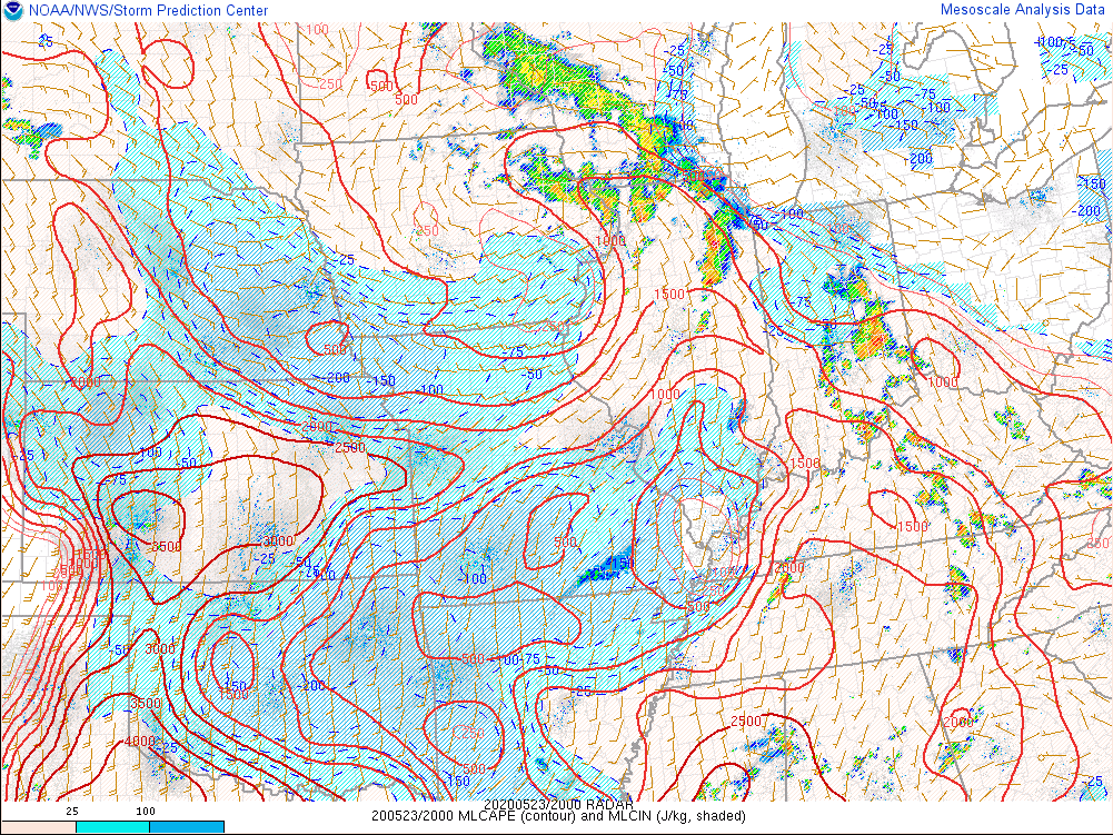 |
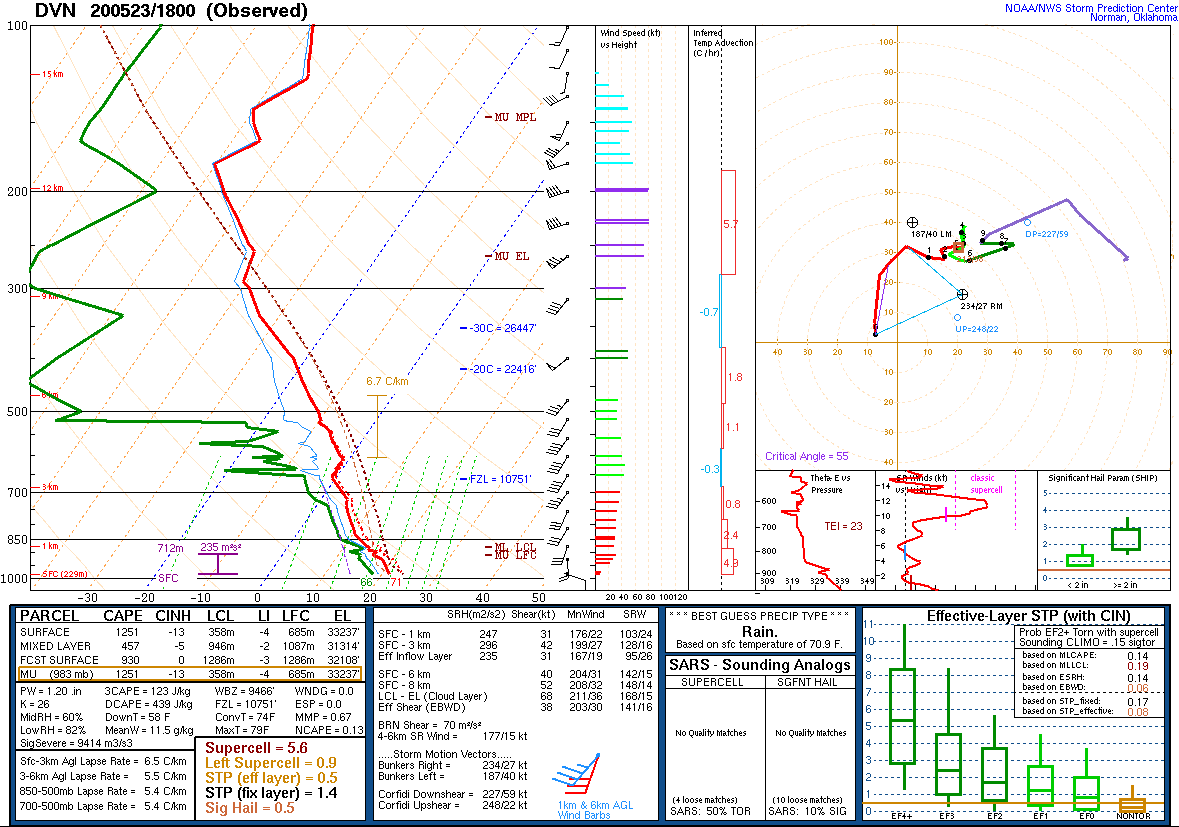
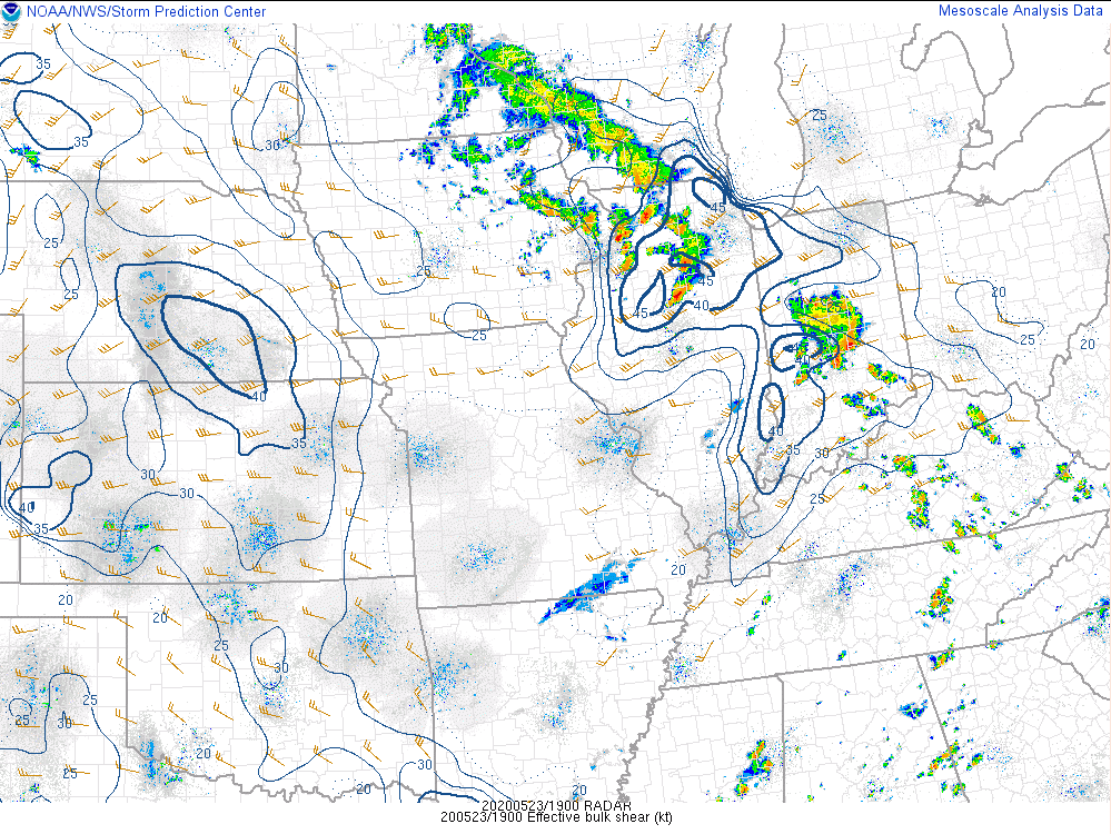
| Special 18z (1 PM) sounding from Davenport, Iowa. | 2 PM SPC Mesoanalysis showing deep layer shear sufficient for supercell thunderstorms. | 3 PM SPC Mesoanalysis showing mixed-layer CAPE values of 1000-1500 J/kg, sufficient for severe storms. |
 |
 |
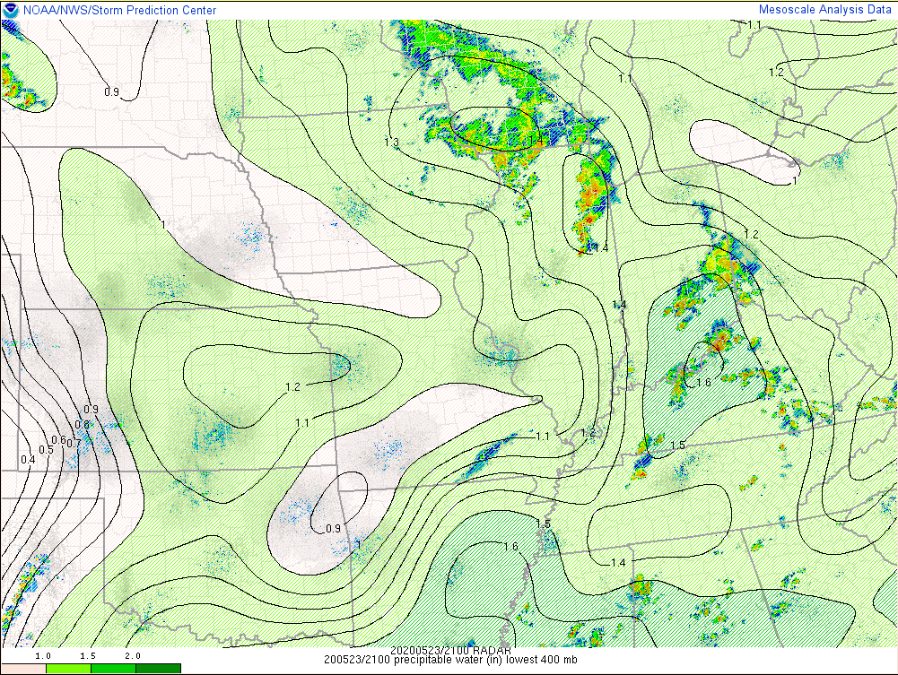 |
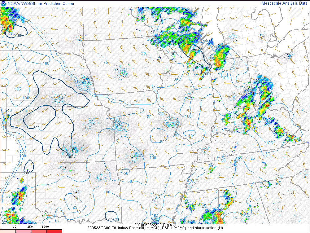
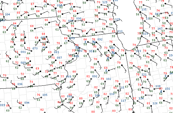
| 6 PM SPC Mesoanalysis depicting effective-inflow SRH in excess of 200 m2/s2. | 2 PM surface map. | 4 PM Precipitable Water values in excess of 1.4" supporting the threat for locally heavy rainfall. |
 |
Media use of NWS Web News Stories is encouraged! Please acknowledge the NWS as the source of any news information accessed from this site. Additional recaps can be found on the NWS Chicago Past Events Page |
|