Heat expands across the Desert Southwest, Plains, Mississippi Valley and Midwest into Monday. Fire weather concerns continue for portions of the Intermountain West. Active monsoonal moisture fuels thunderstorms over the Southwest with possible flash flooding. Tropical cyclone Fausto in the Pacific, should weaken as it approaches Hawaii; Dangerous surf, swells and rip currents are expected. Read More >
Overview
|
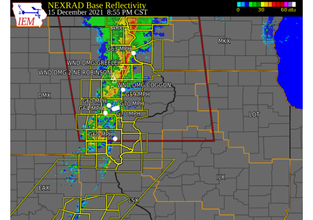
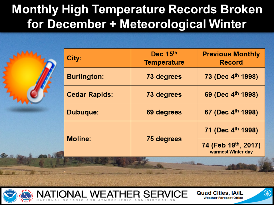
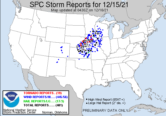
A unique day of weather unfolded across all of eastern Iowa, northwest Illinois and far northeast Missouri. Strong low pressure developed over the Plains and quickly traversed into the Upper Mississippi River Valley, producing very strong winds and record warmth across the Midwest. All climate sites in our area set new record high temperatures, and either broke or tied all-time record December highs. In addition to the warmth, severe thunderstorms occurred across the area during the evening. Winds were the primary concern, with gusts of 60-80 MPH measured from Benton county into the Quad Cities metro. Several reports of damage were also received, with numerous power outages. |
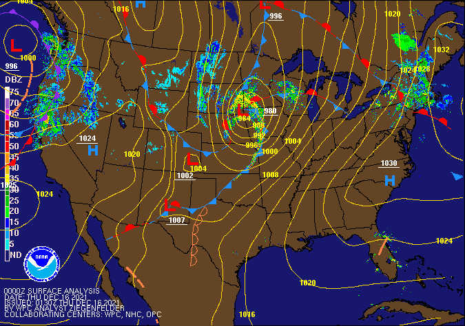 Surface Analysis: Weather Prediction Center (WPC) |
Wind Reports:
PUBLIC INFORMATION STATEMENT
NATIONAL WEATHER SERVICE QUAD CITIES IA IL
320 AM CST THU DEC 16 2021

...HIGHEST WIND REPORTS...

LOCATION                     SPEED     TIME/DATE       LAT/LON
WINNEBAGO                    86 MPH    0938 PM 12/15   42.35N/90.02W
IOWA CITY ARPT               70 MPH    0843 PM 12/15   41.63N/91.55W
DUBUQUE                      69 MPH    0957 PM 12/15   42.46N/90.77W
DUBUQUE ARPT                 69 MPH    1130 PM 12/15   42.40N/90.70W
INDEPENDENCE ARPT            67 MPH    1155 PM 12/15   42.45N/91.95W
1 NNE AURORA                 66 MPH    1255 AM 12/16   42.64N/91.72W
CEDAR RAPIDS ARPT            66 MPH    0826 PM 12/15   41.88N/91.72W
DAVENPORT ARPT               63 MPH    1231 AM 12/16   41.62N/90.58W
MONTICELLO ARPT              63 MPH    1155 PM 12/15   42.22N/91.17W
3 SE MAYSVILLE               63 MPH    1150 PM 12/15   41.60N/90.68W
INDEPENDENCE                 62 MPH    1200 AM 12/16   42.47N/91.88W
BIGGSVILLE                   62 MPH    0914 PM 12/15   40.94N/90.85W
FAIRBANK                     61 MPH    1131 PM 12/15   42.64N/92.05W
STANLEY                      61 MPH    1131 PM 12/15   42.64N/91.81W
BURLINGTON ARPT              61 MPH    0929 PM 12/15   40.77N/91.13W
QUAD CITY INTL ARPT          60 MPH    1024 PM 12/15   41.45N/90.52W
MOUNT PLEASANT ARPT          60 MPH    0855 PM 12/15   40.95N/91.52W
1 E BRANDON                  60 MPH    1230 AM 12/16   42.31N/91.98W
UNIVERSITY HEIGHTS (WEATHERS 59 MPH    0850 PM 12/15   41.66N/91.55W
ELDRIDGE                     59 MPH    1255 AM 12/16   41.64N/90.59W
FAIRFIELD ARPT               59 MPH    0855 PM 12/15   41.03N/91.97W
STOCKTON                     58 MPH    0946 PM 12/15   42.40N/89.99W
MARION                       58 MPH    0906 PM 12/15   42.08N/91.60W
KEOKUK ARPT                  58 MPH    0915 PM 12/15   40.47N/91.42W
MUSCATINE ARPT               58 MPH    1135 PM 12/15   41.37N/91.15W
2 W UNIVERSITY HEIGHTS       58 MPH    0840 PM 12/15   41.66N/91.60W
MAQUOKETA                    58 MPH    0950 PM 12/15   42.07N/90.68W
28THAW                       58 MPH    0823 PM 12/15   41.90N/91.95W
LOWDNW                       58 MPH    0928 PM 12/15   41.85N/90.90W
NEW LONDON                   57 MPH    0930 PM 12/15   40.97N/91.34W
CLINTON ARPT                 56 MPH    1247 AM 12/16   41.82N/90.32W
FORT MADISON ARPT            56 MPH    0915 PM 12/15   40.67N/91.32W
1 W DEWITT                   56 MPH    0953 PM 12/15   41.83N/90.57W
MARION                       55 MPH    1158 PM 12/15   42.10N/91.62W
SAVANNA ARPT                 55 MPH    0915 PM 12/15   42.05N/90.12W
1 SSE MANCHESTER             55 MPH    1220 AM 12/16   42.47N/91.45W
WASHINGTON ARPT              54 MPH    1055 PM 12/15   41.27N/91.67W
FREEPORT ARPT                54 MPH    0130 AM 12/16   42.25N/89.58W
MACOMB ARPT                  54 MPH    0935 PM 12/15   40.52N/90.65W
CENTER GROVE                 53 MPH    0154 AM 12/16   42.49N/90.73W
URBANA                       52 MPH    0815 PM 12/15   42.22N/91.88W
TIPTON                       52 MPH    0630 PM 12/15   41.77N/91.13W
ELDRIDGE                     52 MPH    1200 AM 12/16   41.65N/90.59W
RIVERSIDE                    52 MPH    0856 PM 12/15   41.53N/91.62W
VINTON ARPT                  52 MPH    1135 PM 12/15   42.22N/92.02W
1 N WILLIAMSBURG             52 MPH    0800 PM 12/15   41.69N/92.01W
STOCKTON 3 NNE               52 MPH    0900 PM 12/15   42.40N/90.00W
FLAGSTAFF CHESHIRE           51 MPH    0816 PM 12/15   41.59N/90.55W
MONMOUTH                     51 MPH    0955 PM 12/15   40.93N/90.63W
0.6 W LOWDEN (UPR)           51 MPH    0932 PM 12/15   41.86N/90.93W
MECHANICSVILLE (UPR)         50 MPH    0905 PM 12/15   41.90N/91.26W
 |
 |
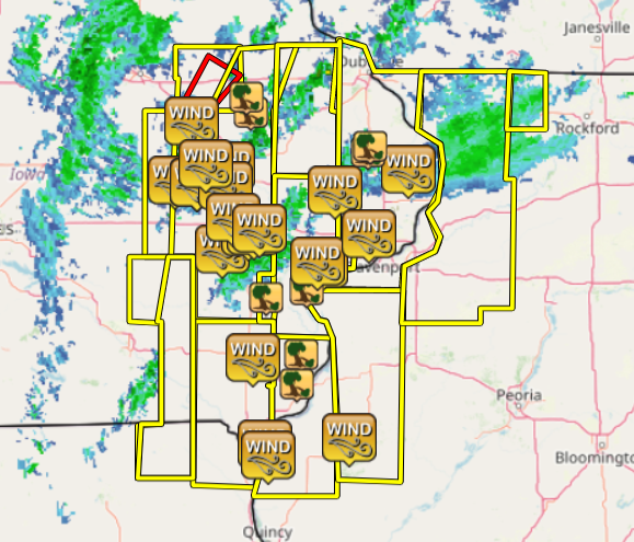
Storm Reports
| Interactive Storm Report Map (IEM) | SPC Storm Reports | |
 |
 |
PRELIMINARY LOCAL STORM REPORT...SUMMARY
NATIONAL WEATHER SERVICE QUAD CITIES IA IL
1029 PM CST WED DEC 15 2021

..TIME...   ...EVENT...      ...CITY LOCATION...     ...LAT.LON...
..DATE...   ....MAG....      ..COUNTY LOCATION..ST.. ...SOURCE....
            ..REMARKS..
1030 PM     TSTM WND DMG     FREEPORT                42.30N 89.63W
12/15/2021                   STEPHENSON         IL   TRAINED SPOTTER

            SPOTTER REPORT A TEN INCH DIAMETER TREE
            UPROOTED AGAINST A HOUSE.
0949 PM     TSTM WND GST     4 SE BLANDINSVILLE      40.51N 90.82W
12/15/2021  M68 MPH          MCDONOUGH          IL   PUBLIC

            68 MPH MEASURED WIND GUST.

0940 PM     TSTM WND GST     3 SE MAYSVILLE          41.62N 90.68W
12/15/2021  M60 MPH          SCOTT              IA   PUBLIC


0939 PM     TSTM WND DMG     1 E HURSTVILLE          42.10N 90.67W
12/15/2021                   JACKSON            IA   PUBLIC

            POWER POLES BROKEN.

0938 PM     TSTM WND DMG     1 NW MAQUOKETA          42.07N 90.68W
12/15/2021                   JACKSON            IA   PUBLIC

            POWER POLES BROKEN.

0930 PM     TSTM WND DMG     3 ESE COTTER            41.28N 91.42W
12/15/2021                   LOUISA             IA   AMATEUR RADIO

            TREE DOWN ON ROADWAY ABOUT 3 W COLUMBUS
            JUNCTION.

0930 PM     TSTM WND DMG     3 ESE COTTER            41.28N 91.42W
12/15/2021                   LOUISA             IA   AMATEUR RADIO

            TREE DOWN ON ROADWAY ABOUT 3 W OF COLUMBUS
            JUNCTION.

0927 PM     TSTM WND GST     4 NNE MUSCATINE         41.47N 91.05W
12/15/2021  M60 MPH          MUSCATINE          IA   CO-OP OBSERVER


0925 PM     TSTM WND GST     LOWDEN                  41.86N 90.92W
12/15/2021  M70 MPH          CEDAR              IA   CO-OP OBSERVER


0924 PM     TSTM WND DMG     3 NE MUSCATINE          41.46N 91.03W
12/15/2021                   MUSCATINE          IA   PUBLIC

            POWER POLES BROKEN.

0922 PM     TSTM WND DMG     2 SW WEST BURLINGTON    40.81N 91.20W
12/15/2021                   DES MOINES         IA   TRAINED SPOTTER

            SHED BLOWN DOWN AND SKIRTING BLOWN OFF A
            MOBILE HOME.

0919 PM     TSTM WND DMG     2 NNE DODGEVILLE        40.97N 91.17W
12/15/2021                   DES MOINES         IA   TRAINED SPOTTER

            TREE DOWN ON POWER LINES. TIME ESTIMATED BY
            RADAR.

0913 PM     TSTM WND DMG     2 S FRUITLAND           41.32N 91.13W
12/15/2021                   LOUISA             IA   PUBLIC

            PART OF A BUILDING BLOWN INTO THE ROADWAY.

0910 PM     TSTM WND GST     KEOKUK                  40.41N 91.41W
12/15/2021  M60 MPH          LEE                IA   TRAINED SPOTTER


0906 PM     TSTM WND GST     KEOKUK AIRPORT          40.47N 91.43W
12/15/2021  M58 MPH          LEE                IA   AWOS


0905 PM     NON-TSTM WND DMG GOOSE LAKE              41.97N 90.39W
12/15/2021                   CLINTON            IA   PUBLIC

            CAR PORT BLOWN OVER.
0903 PM     TSTM WND GST     1 SSW FAIRVIEW          42.07N 91.34W
12/15/2021  M59 MPH          JONES              IA   DEPT OF HIGHWAYS

            DELAYED REPORT. IADOT RWIS.


0900 PM     TSTM WND GST     4 E IOWA CITY           41.65N 91.47W
12/15/2021  E70 MPH          JOHNSON            IA   TRAINED SPOTTER

            POWER OUT.

0857 PM     TSTM WND GST     1 ENE TIFFIN            41.71N 91.66W
12/15/2021  E60 MPH          JOHNSON            IA   TRAINED SPOTTER


0855 PM     TSTM WND GST     MOUNT PLEASANT MUNICIPA 40.95N 91.52W
12/15/2021  M60 MPH          HENRY              IA   AWOS


0854 PM     TSTM WND GST     2 SE IOWA CITY          41.64N 91.51W
12/15/2021  M70 MPH          JOHNSON            IA   TRAINED SPOTTER


0852 PM     TSTM WND GST     IOWA CITY MUNICIPALITY  41.63N 91.55W
12/15/2021  M70 MPH          JOHNSON            IA   ASOS


0852 PM     TSTM WND GST     2 SSW WILLIAMSTOWN      41.54N 91.74W
12/15/2021  M64 MPH          JOHNSON            IA   TRAINED SPOTTER
0849 PM     TSTM WND DMG     GREELEY                 42.58N 91.34W
12/15/2021                   DELAWARE           IA   BROADCAST MEDIA

            HOUSE AND ROOF DAMAGE IN GREELEY AND ONEIDA.

0848 PM     TSTM WND DMG     2 NE ROBINSON           42.36N 91.56W
12/15/2021                   DELAWARE           IA   TRAINED SPOTTER

            SHINGLE DAMAGE REPORTED AS WELL AS OTHER
            DAMAGE IN THE NEIGHBORHOOD.

0847 PM     NON-TSTM WND GST 3 NE MUSCATINE          41.46N 91.03W
12/15/2021  M62 MPH          MUSCATINE          IA   PUBLIC

            NON-THUNDERSTORM WIND GUST FROM PUBLIC
            WEATHER STATION. TREE BRANCHES DOWN IN
            NEIGHBORHOOD.

0845 PM     TSTM WND DMG     COGGON                  42.28N 91.53W
12/15/2021                   LINN               IA   TRAINED SPOTTER

            TREE DOWN ON HOUSE. TIME ESTIMATED BY RADAR.

0842 PM     TSTM WND DMG     2 WNW CORALVILLE        41.70N 91.63W
12/15/2021                   JOHNSON            IA   TRAINED SPOTTER

            ESTIMATED 70 MPH WIND GUST KNOCKED DOWN A
            TIN SHED.
0838 PM     TSTM WND GST     HIAWATHA                42.05N 91.68W
12/15/2021  E80 MPH          LINN               IA   TRAINED SPOTTER

            CORRECTS THE TIME FROM THE PREVIOUS TSTM WND
            GST REPORT FROM HIAWATHA. SPOTTERR ESTIMATED
            WIND GUST OF 80 MPH BUT NO WAS DAMAGE NOTED.
            ALSO REPORTED SEVERAL 60 MPH GUSTS AROUND
            THAT TIME FRAME.
0832 PM     TSTM WND DMG     1 E TIFFIN              41.71N 91.66W
12/15/2021                   JOHNSON            IA   PUBLIC

            THUNDERSTORM WINDS THREW TRAMPOLINE AGAINST
            HOUSE, CAUSING A METAL POLE TO PIERCE THE
            SIDING AND ENTER THE HOUSE. TIME IS
            ESTIMATED BY RADAR.
0832 PM     TSTM WND GST     ATKINS                  42.00N 91.86W
12/15/2021  M65 MPH          BENTON             IA   FIRE DEPT/RESCUE
0830 PM     TSTM WND DMG     1 WSW WALFORD           41.88N 91.86W
12/15/2021                   BENTON             IA   BROADCAST MEDIA

            *** 1 FATAL ***
            SEVERE THUNDERSTORMS WINDS CAUSED A
            SEMI-TRAILER BLOW-OVER. THE DRIVER WAS
            THROWN FROM THE VEHICLE AND PRONOUNCED DEAD
            AT THE SCENE.

0830 PM     TSTM WND GST     CEDAR RAPIDS MUNICIPALI 41.88N 91.72W
12/15/2021  M66 MPH          LINN               IA   ASOS


0826 PM     TSTM WND GST     NORWAY                  41.90N 91.92W
12/15/2021  M70 MPH          BENTON             IA   PUBLIC

            REPORT RELAYED BY EM.

0824 PM     TSTM WND GST     NORWAY                  41.90N 91.92W
12/15/2021  E65 MPH          BENTON             IA   TRAINED SPOTTER

            REPORT RELAYED BY EM.

0820 PM     TSTM WND GST     2 SW CHENEY             42.23N 91.96W
12/15/2021  M76 MPH          BENTON             IA   BROADCAST MEDIA
0813 PM     TSTM WND DMG     STANLEY                 42.64N 91.81W
12/15/2021                   BUCHANAN           IA   TRAINED SPOTTER

            TREE REPORTED DOWN IN STANLEY. TIME
            ESTIMATED FROM RADAR.

0813 PM     TSTM WND DMG     2 SSW CHENEY            42.22N 91.94W
12/15/2021                   BENTON             IA   BROADCAST MEDIA

            TREE DOWN OVER HIGHWAY 150.

0802 PM     TSTM WND GST     BLAIRSTOWN              41.91N 92.08W
12/15/2021  E60 MPH          BENTON             IA   FIRE DEPT/RESCUE

            REPORT RELAYED FROM EM.

0731 PM     NON-TSTM WND DMG 2 NW CEDAR RAPIDS       41.99N 91.70W
12/15/2021                   LINN               IA   PUBLIC

            REPORT FROM MPING: 1-INCH TREE LIMBS BROKEN;
            SHINGLES BLOWN OFF.
Rain Reports
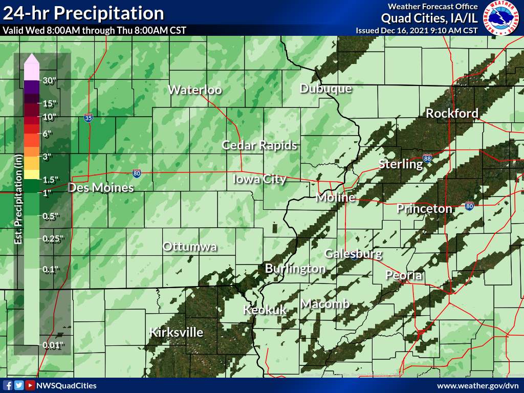
24 hour precipitation reports (in Inches),
for eastern Iowa, northwest and west central Illinois,
and northeast Missouri. Reported between Midnight and 9 AM,
Thursday December 16, 2021.

....IOWA....
Marshalltown ASOS  N             0.49
Guttenberg Dam 10                0.45
Oelwein AWOS                     0.43
Manchester                       0.42
Waterloo ASOS  NW                0.41
Marengo                          0.41
NWS Johnston* 5 NNW              0.41
Newton 1 NE                      0.40
Ames US 30 2 SSE                 0.40
Boone 1 SSW                      0.38
Perry 0 W                        0.30
Center Point 0.6 NNW             0.28
Mount Auburn 2.2 NNW             0.28
Williamsburg                     0.28
Pella 4 N                        0.28
Elkader 6SSW                     0.27
Marshalltown 1 NW                0.27
Marengo 2.6 SSW                  0.26
Fayette 1 NW                     0.25
Pella AWOS 2 WSW                 0.24
Marion 1.7 NNW                   0.22
Beaconsfield 1 NNE               0.18
Oskaloosa 1 NNW                  0.18
Marengo 3.6 N                    0.15
Sigourney                        0.15
Tipton 0.7 N                     0.12
Parnell 0.1 SSW                  0.12
Calamus 2.0 NE                   0.11
Cedar Rapids Arpt                0.09
Ottumwa ASOS  NNW                0.08
Dubuque Arpt                     0.08
Fairfax 4.0 NW                   0.07
Bellevue LD12                    0.07
Rathbun Reservoir 2 N            0.06
Muscatine 2.1 N                  0.05
Keokuk LD19                      0.05
Washington                       0.05
North English                    0.05
Ainsworth 7.4 N                  0.04
Charlotte 1.9 WNW                0.04
Solon 0.3 ESE                    0.04
Iowa City Arpt                   0.04
Fort Madison 0.9 NE              0.03
Wapello 5.4 SE                   0.03
Wapello 0.2 S                    0.03
West Branch 2.0 NNW              0.03
Oskaloosa AWOS 9 ESE             0.03
Davenport Arpt                   0.03
Dubuque #3 7 SW                  0.03
Mt Pleasant 1 SSW                0.02
Monticello 1 E                   0.02
Anamosa 3 SSW                    0.02
Muscatine 2N                     0.02
Burlington Arpt                  0.02
North Liberty 0.7 SSW            0.01
Keosauqua                        0.01
New London 1.5 SW                0.00
Morning Sun 1.7 E                0.00
Davenport 0.9 WNW                0.00
Camanche 1.2 W                   0.00
Mason City 1 NNE                 0.00
Burlington 6.5 SSW               0.00
Wellman 4.0 E                    0.00
Hampton 1 N                      0.00
Columbus Jct 2 SSW               0.00
Dubuque LD11                     0.00
Donnellson                       0.00
Centerville 0 NE                 0.00
Iowa City                        0.00
....ILLINOIS....
Tuscola                          0.19
Decatur Airport                  0.08
Dallas City 3.0 SSE              0.06
Mundelein                        0.06
Windsor                          0.06
Augusta                          0.06
New Windsor 2.0 N                0.04
Gladstone LD18                   0.04
Coal Valley 2.6 E                0.03
Ogden                            0.03
Quad City Arpt                   0.03
Stronghurst 0.4 SSW              0.02
Winslow 4.3 ESE                  0.02
Elizabeth                        0.02
New Boston LD17                  0.02
Lincoln NWS                      0.02
Bentley                          0.02
Geneseo 2.0 NW                   0.01
Coal Valley 1.9 SE               0.01
Mount Carroll 6.8 NNW            0.01
Freeport 1.7 NW                  0.01
Ill. City LD16 3 WNW             0.01
Romeoville                       0.01
Bloomington Airport              0.01
Jacksonville 2E                  0.01
Joliet                           0.01
Colchester 3.5 NE                0.00
Galva 2.7 NE                     0.00
Davis 0.5 N                      0.00
Prairie City 2S                  0.00
Rockford ASOS                    0.00
Galesburg                        0.00
Peoria ASOS                      0.00
Altona                           0.00
Aledo                            0.00
Princeton 1.1 SE                 0.00
Jacksonville AWOS                0.00
Princeton                        0.00
Freeport                         0.00
Paw Paw 1 E                      0.00
Steward                          0.00
Rochelle AWOS                    0.00
Ottawa 4 SW                      0.00
Streator 3 SE                    0.00
Kewanee 1 E                      0.00
Mendota 2 SE                     0.00
Quincy ASOS                      0.00
Fulton LD13                      0.00
Rock Falls                       0.00
....MISSOURI....
Memphis                          0.10
Chillicothe 2 NW                 0.09
Kirksville ASOS                  0.01
Columbia                         0.00
....WISCONSIN....
Lancaster 4WSW                   0.55
La Crosse WFO                    0.46
Viroqua                          0.45
Prairie du Chien AWOS            0.31
Steuben 4SE 3 NE                 0.26
Environment
 |
 |
 |
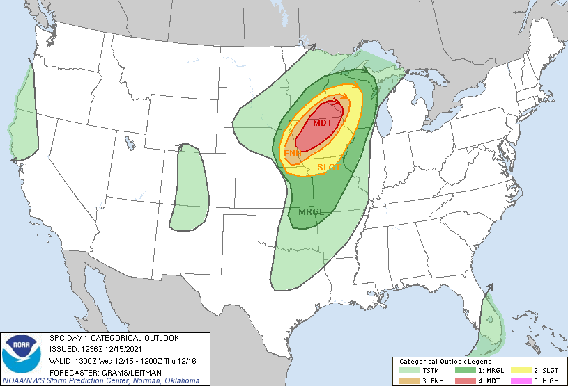
| Figure 1: Day 1 Severe Outlook (issued 12/15 636a) |
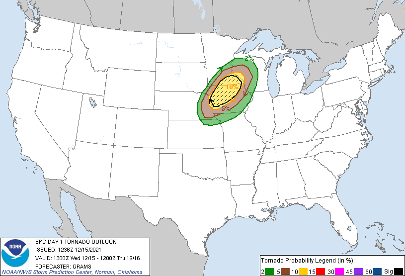
Figure 2: Day 1 Tornado Outlook (issued 12/15 636a) |
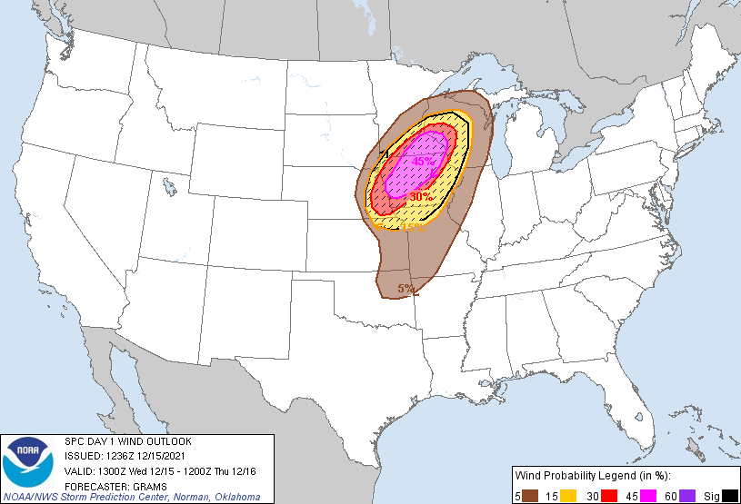
Figure 3: Day 1 Wind Outlook (issued 12/15 636a) |
 |
 |
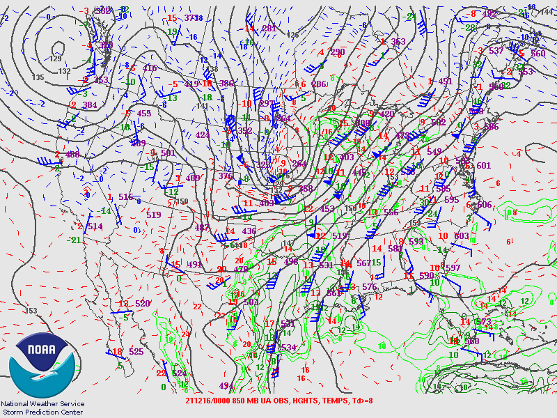 |
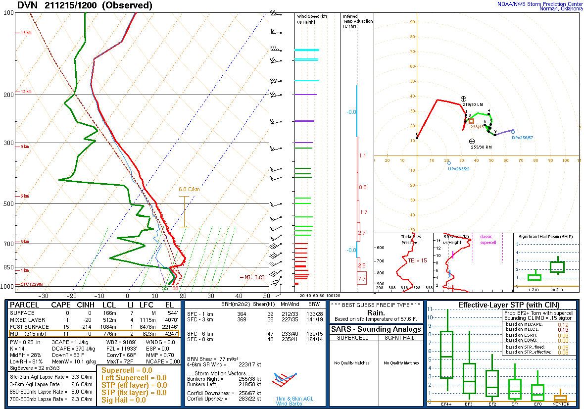
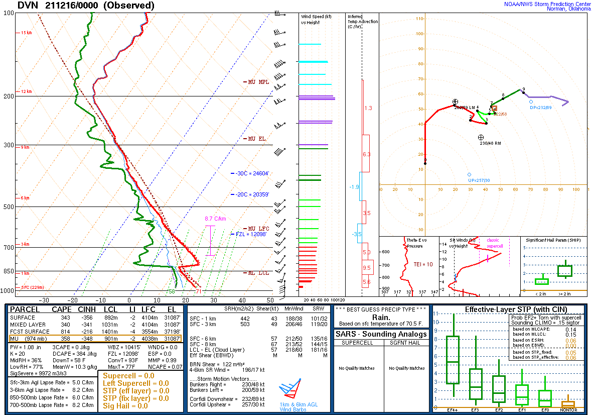
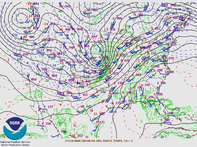
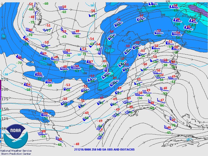
| Figure 4: 12z 12/15 DVN Sounding | Figure 5: 00z 12/16 DVN Sounding | Figure 6: 00z 12/16 850mb analysis |
 |
 |
|
| Figure 7: 00z 12/16 750mb analysis | Figure 8: 00z 12/16 250mb analysis |
Additional Information
Summaries from other NWS Offices
 |
Media use of NWS Web News Stories is encouraged! Please acknowledge the NWS as the source of any news information accessed from this site. |
|