Overview
|
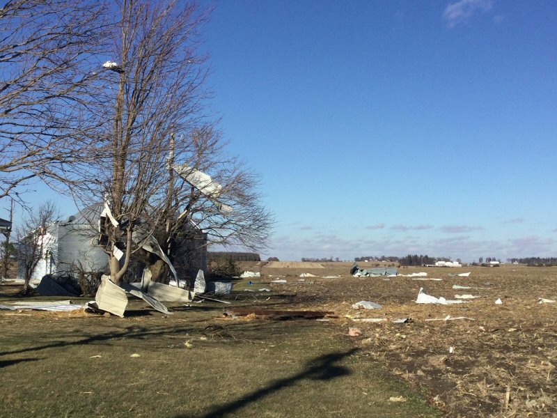
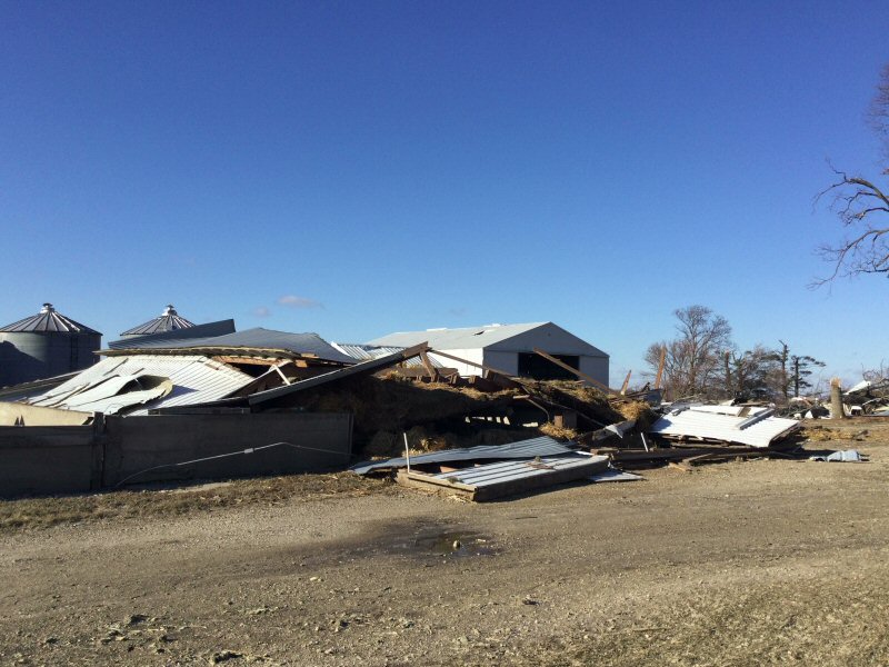
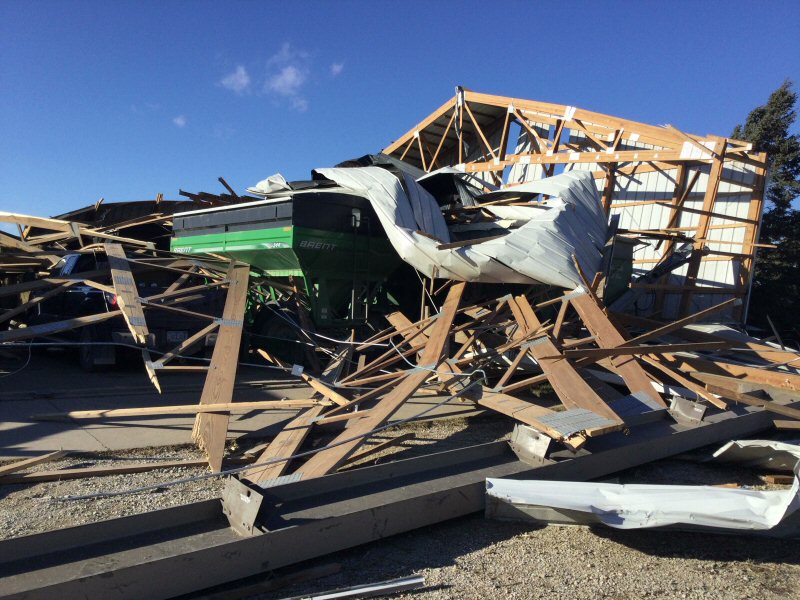
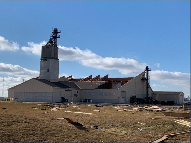
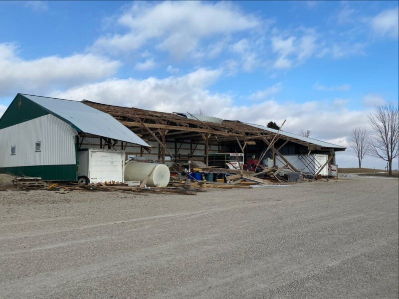
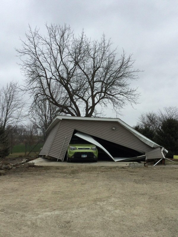
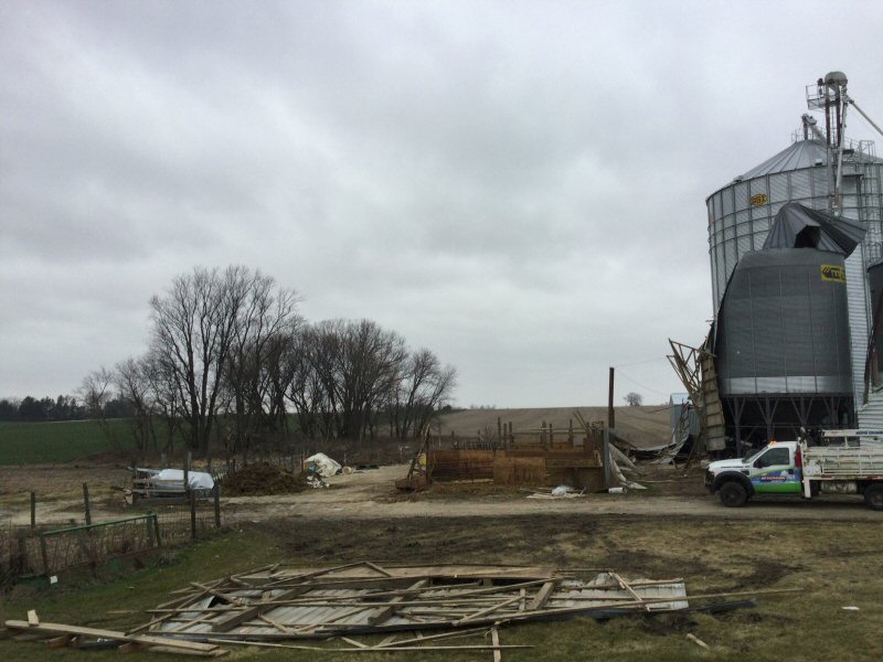
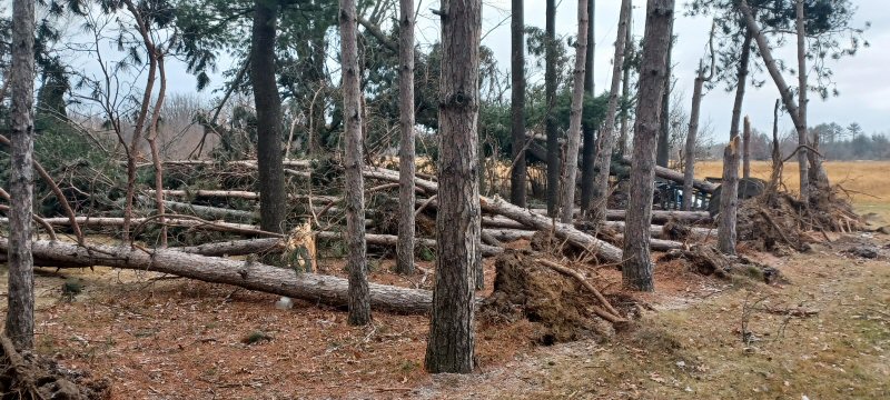
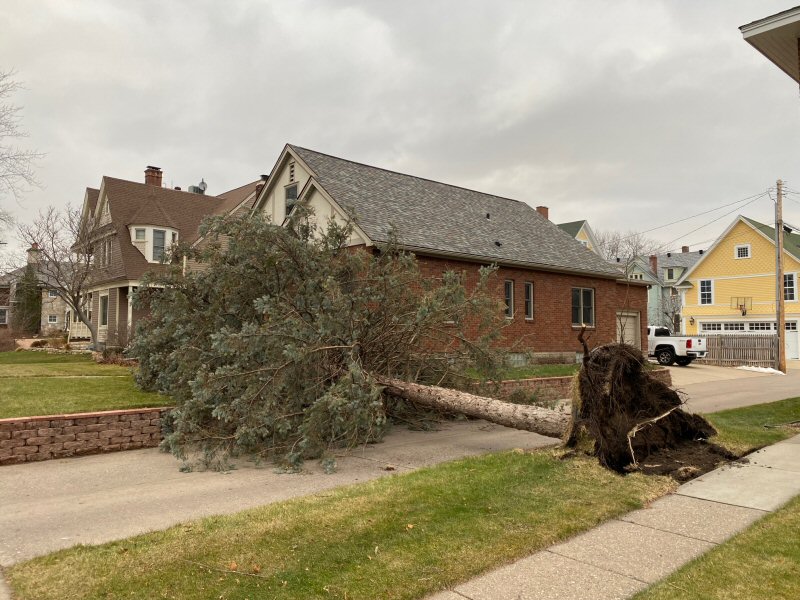
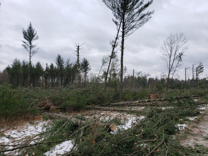
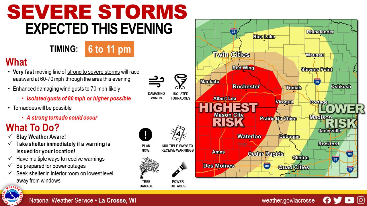
A rare December severe weather event impacted our area during the evening of December 15th. Not only was this one of the highest threats for severe weather so late in the year (December) but shattered records for number of warnings so late in the season. In addition, several all-time December temperature records were set. The storm posed 2 threats. A line of severe thunderstorms brought pockets of wind damage (60-90 mph) along with nearly 30 tornadoes. Some of the stronger tornadoes occurred in north central Wisconsin (Clark Co., WI) where a few homes were destroyed or heavily damaged. The storms were moving very rapidly. After the storms passed, strong winds buffeted the region with fairly widespread 60-80 mph wind gusts. This led to even more damage, especially to trees and farm buildings. All in all, numerous communities suffered structure damage, power outages, and sporadic tree/branch damage. To view the story map for this event, refer to this link.
|
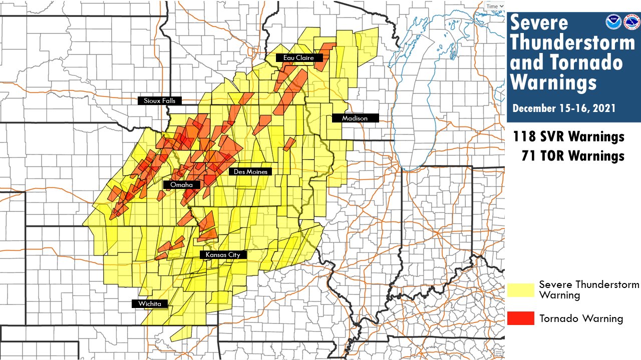 Severe Thunderstorm and Tornado Warnings Issued on Dec.15th |
Tornadoes:
|
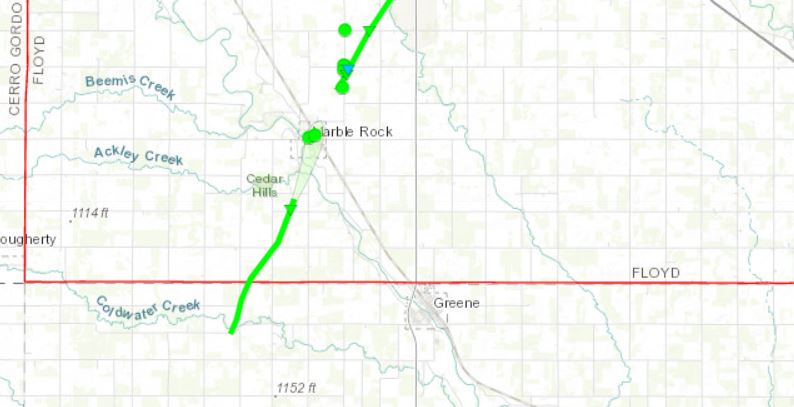
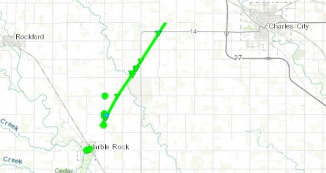
Tornado - SOUTH of MARBLE ROCK
|
||||||||||||||||
|
Tornado - MARBLE ROCK
|
||||||||||||||||
|
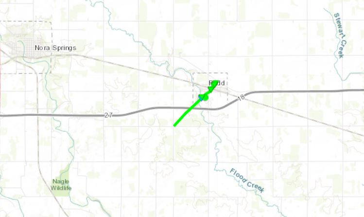
Tornado - RUDD
|
||||||||||||||||
|
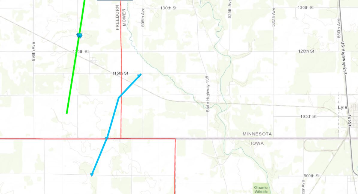
Tornado - SE LONDON MN
|
||||||||||||||||
|
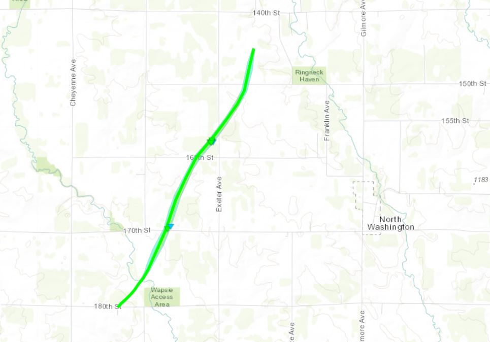
Tornado - NORTH WASHINGTON
|
||||||||||||||||
|
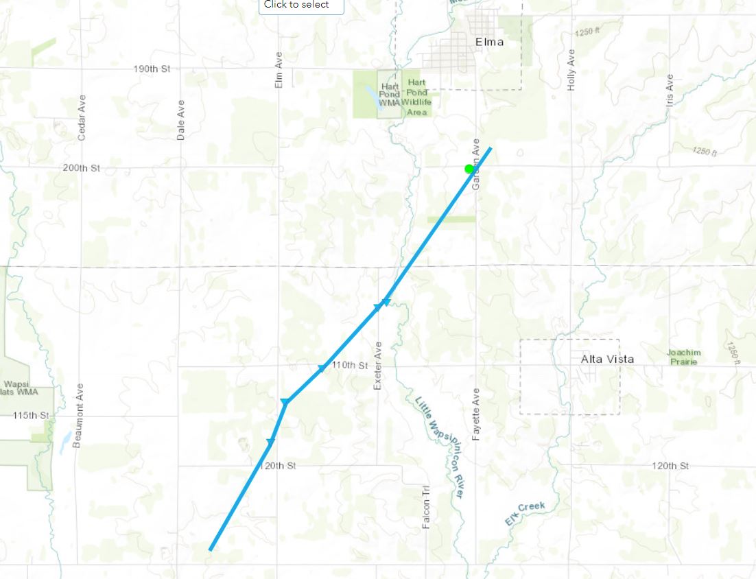
Tornado - ELMA
|
||||||||||||||||
|
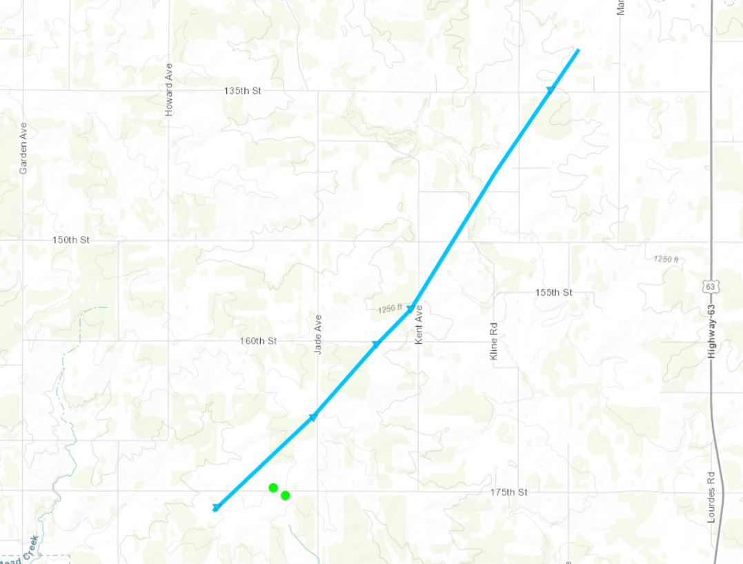
Tornado - MAPLE LEAF
|
||||||||||||||||
|
Tornado - SCHLEY
|
||||||||||||||||
|
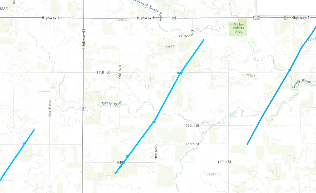
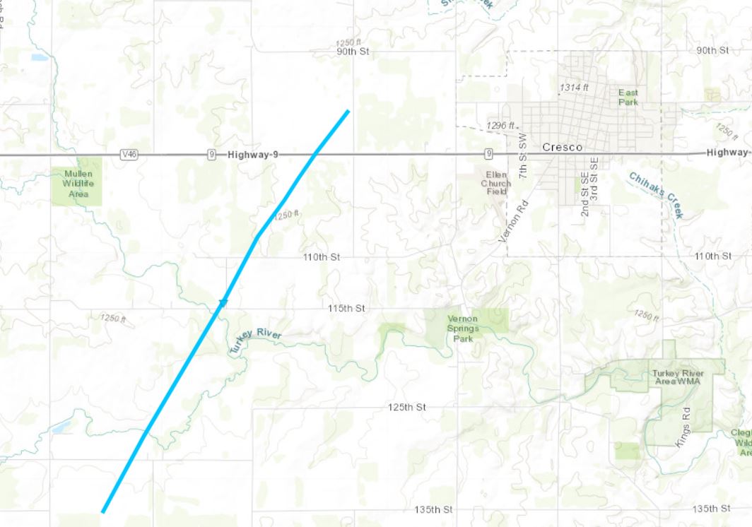
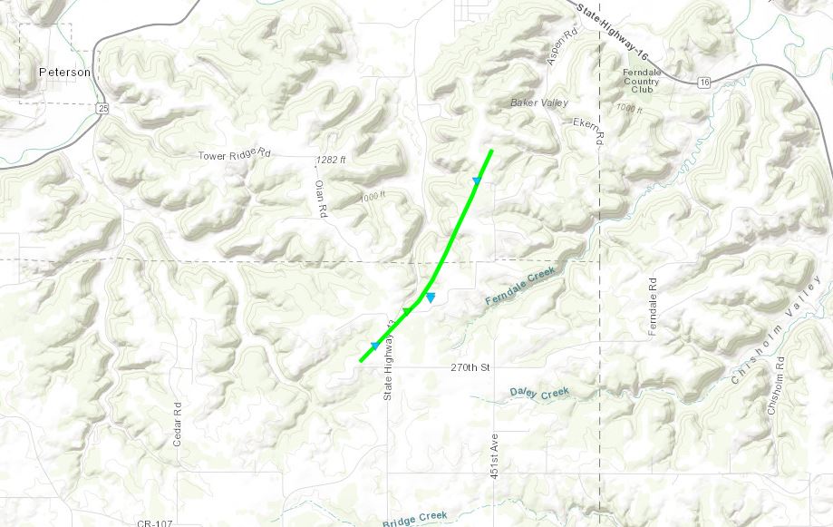
Tornado - CRESCO
|
||||||||||||||||
|
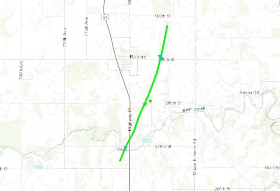
Tornado - RACINE
|
||||||||||||||||
|
Tornado - SUMNER
|
||||||||||||||||
|
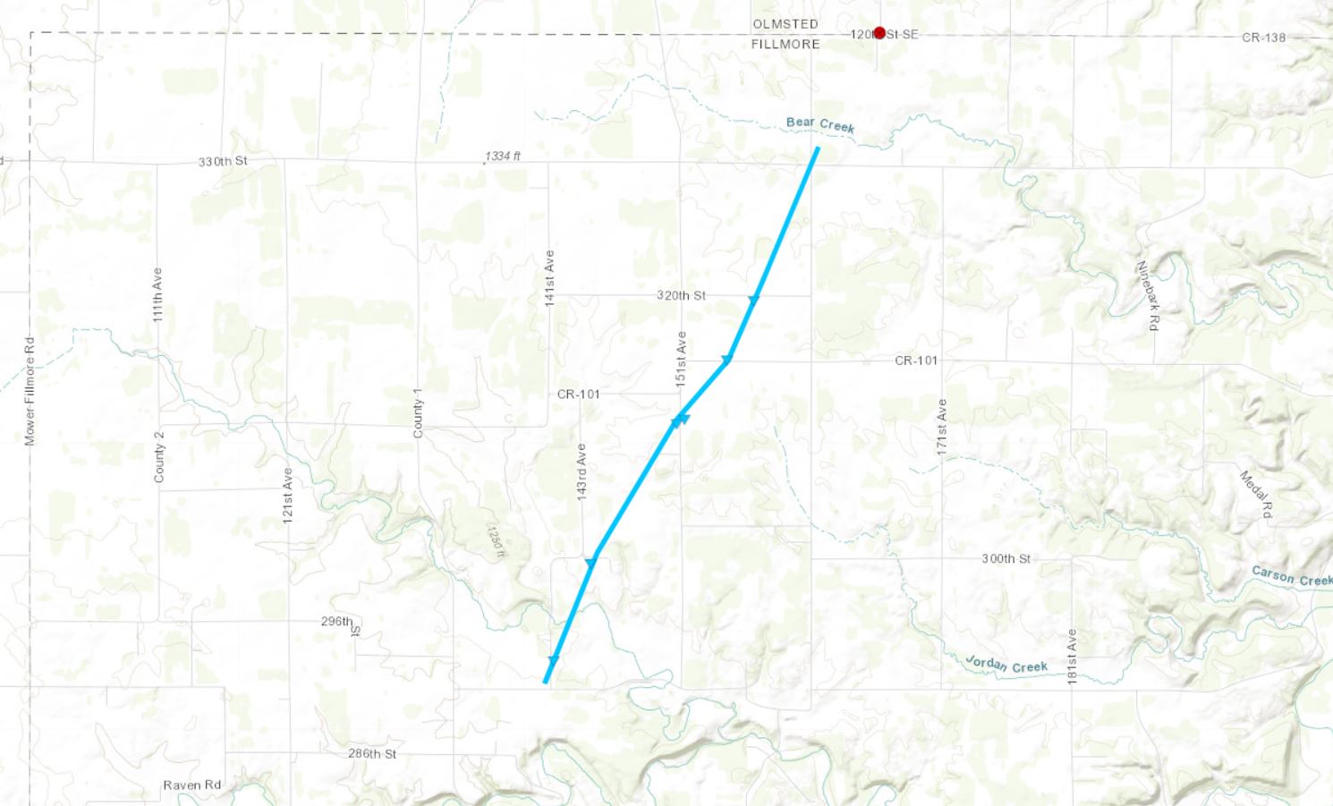
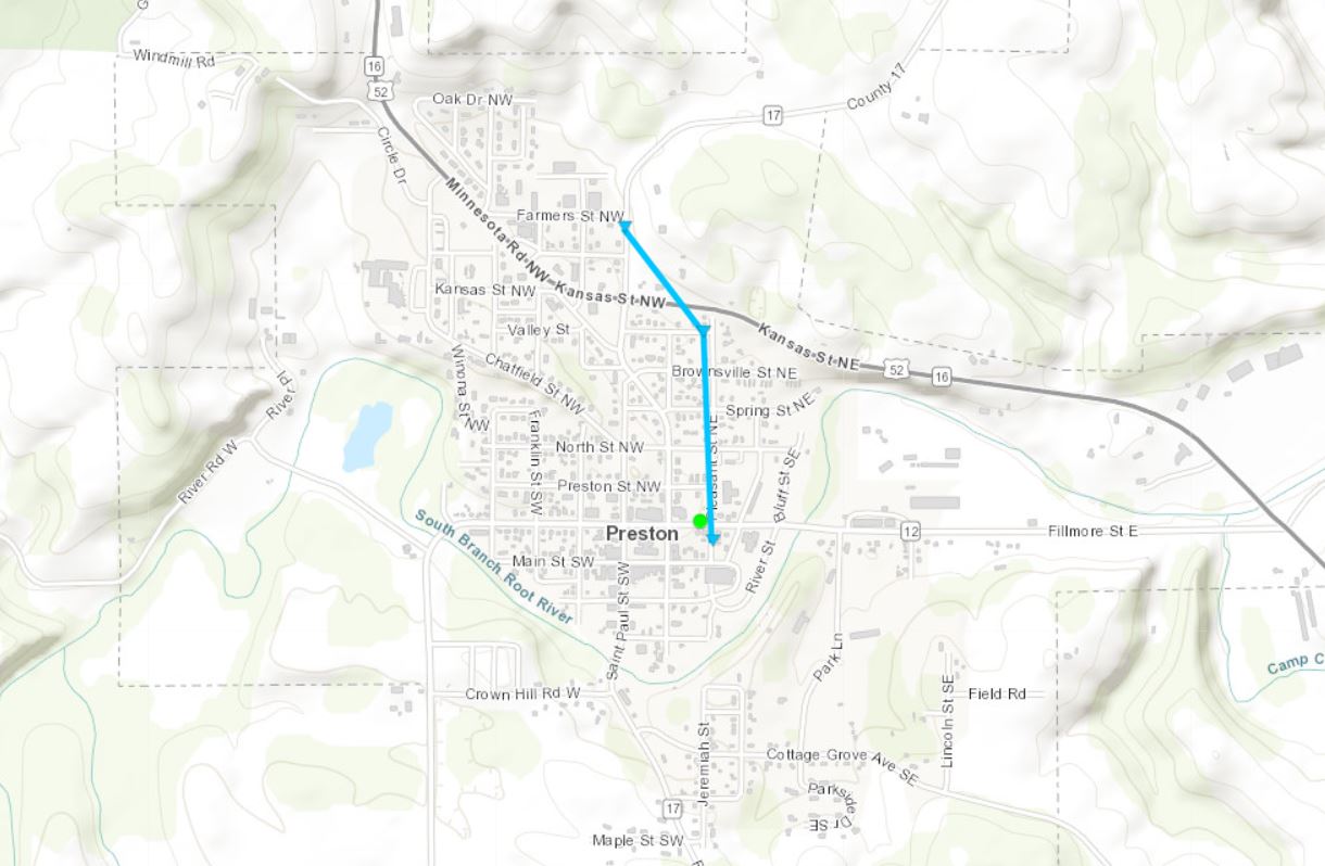
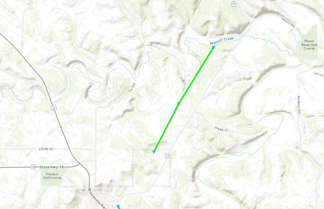
Tornado - PRESTON
|
||||||||||||||||
|
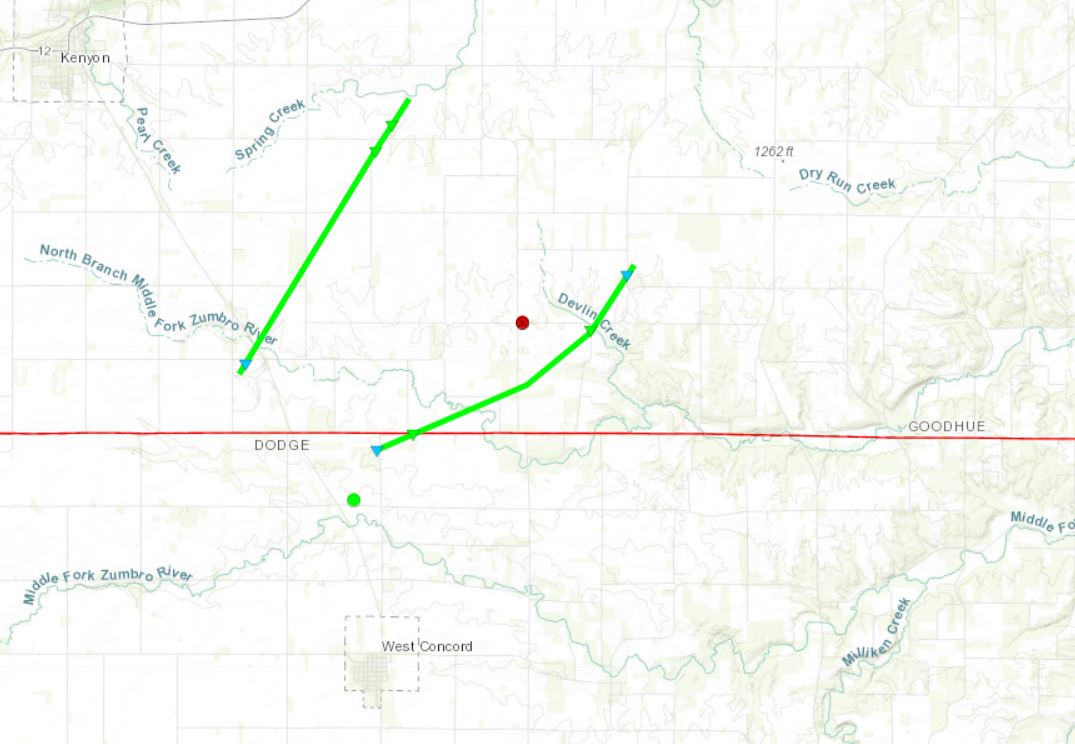
Tornado - WEST CONCORD
|
||||||||||||||||
|
Tornado - CARROLTON
|
||||||||||||||||
|
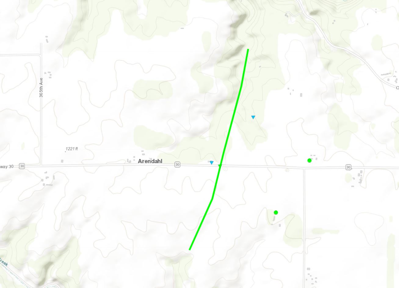
Tornado - ARENDAHL
|
||||||||||||||||
|
Tornado - RUSHFORD VILLAGE
|
||||||||||||||||
|
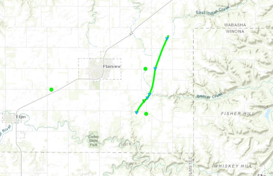
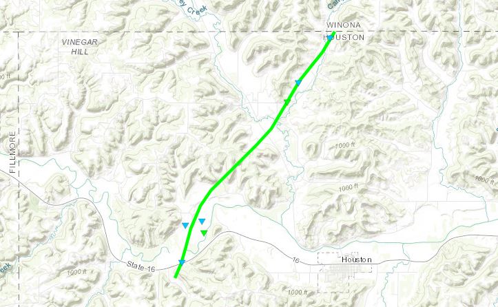
Tornado - PLAINVIEW AREA
|
||||||||||||||||
|
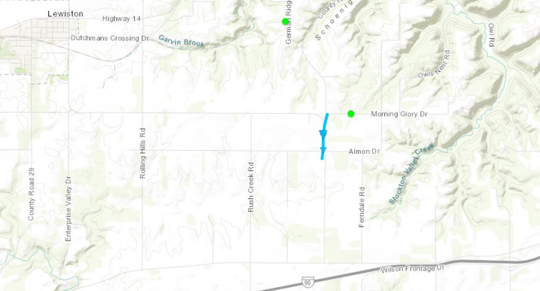
Tornado - MONEY CREEK
|
||||||||||||||||
|
Tornado - WYATTVILLE
|
||||||||||||||||
|
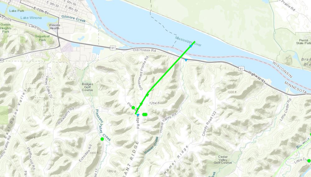
Tornado - HOMER
|
||||||||||||||||
|
Tornado - TREMPEALEAU
|
||||||||||||||||
|
Tornado - LEVIS
|
||||||||||||||||
|
Tornado - HEWETT TOWNSHIP
|
||||||||||||||||
|
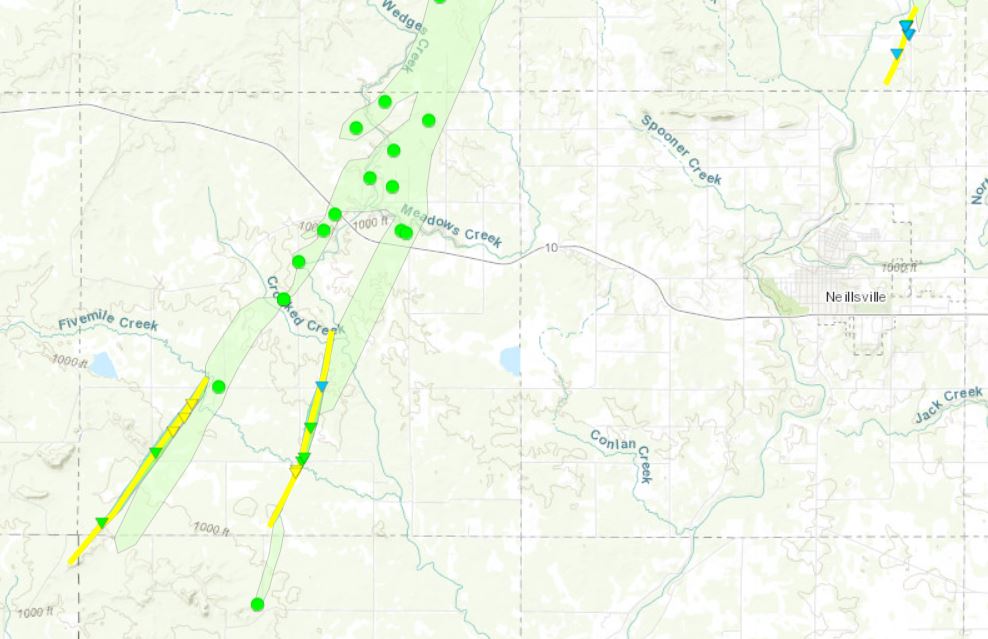
Tornado - FIVEMILE CREEK
|
||||||||||||||||
|
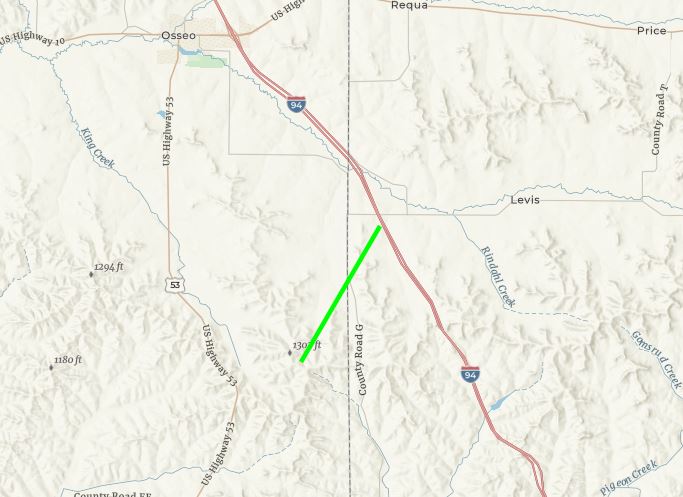
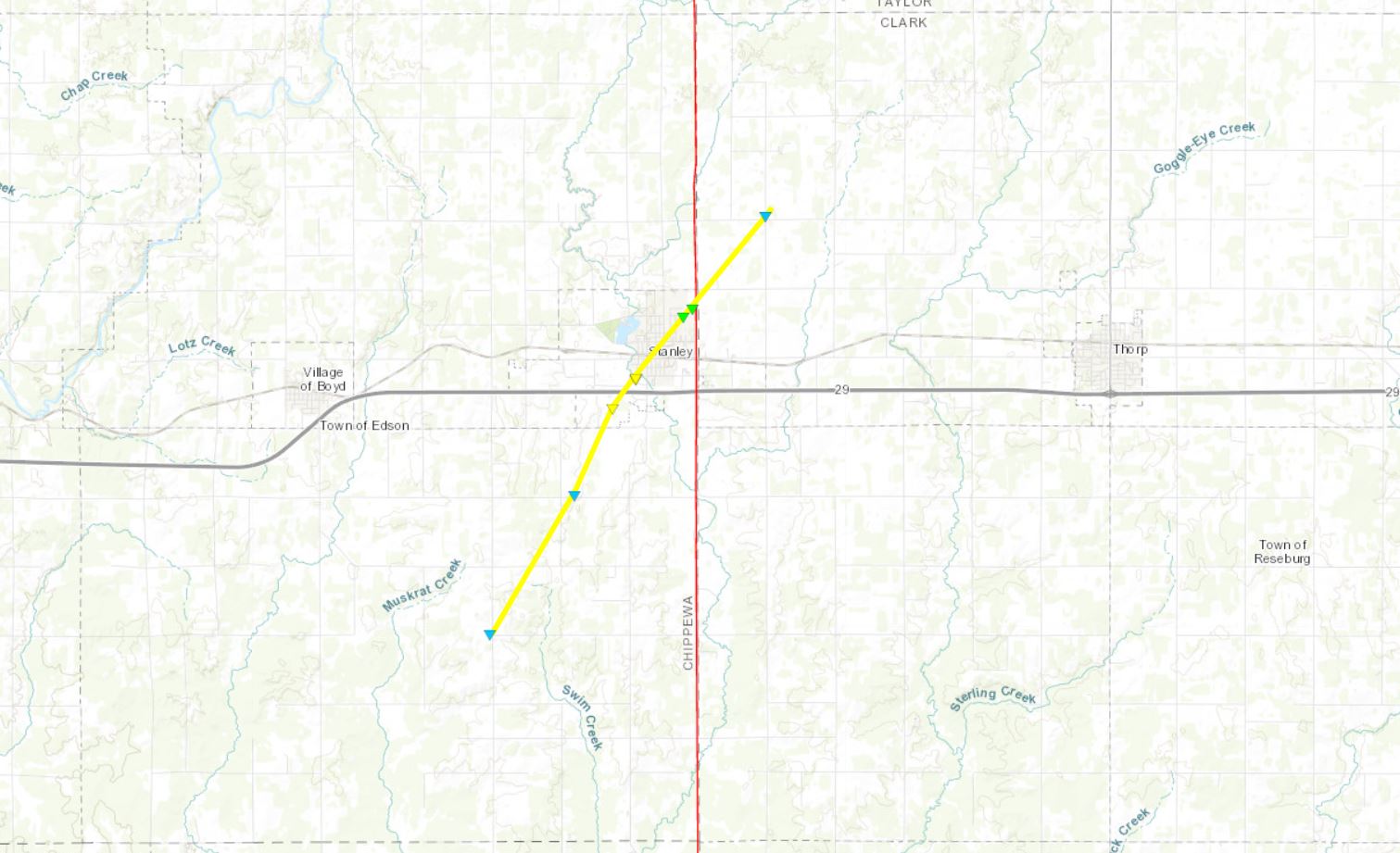
Tornado - STANLEY AREA
|
||||||||||||||||
|
Tornado - CHRISTE
|
||||||||||||||||
|
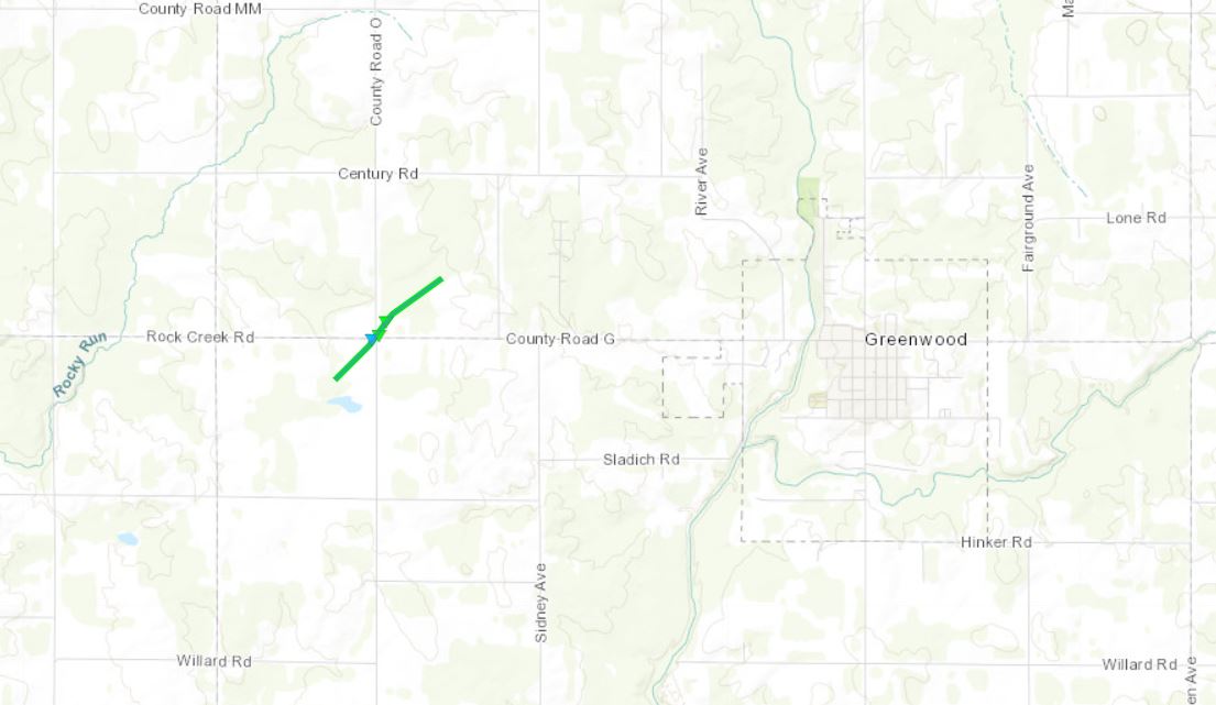
Tornado - GREENWOOD
|
||||||||||||||||
The Enhanced Fujita (EF) Scale classifies tornadoes into the following categories:
| EF0 Weak 65-85 mph |
EF1 Moderate 86-110 mph |
EF2 Significant 111-135 mph |
EF3 Severe 136-165 mph |
EF4 Extreme 166-200 mph |
EF5 Catastrophic 200+ mph |
 |
|||||
Wind:
 |
 |
 |
|
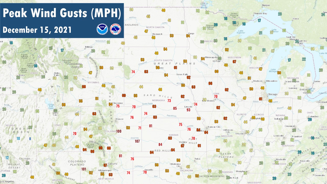
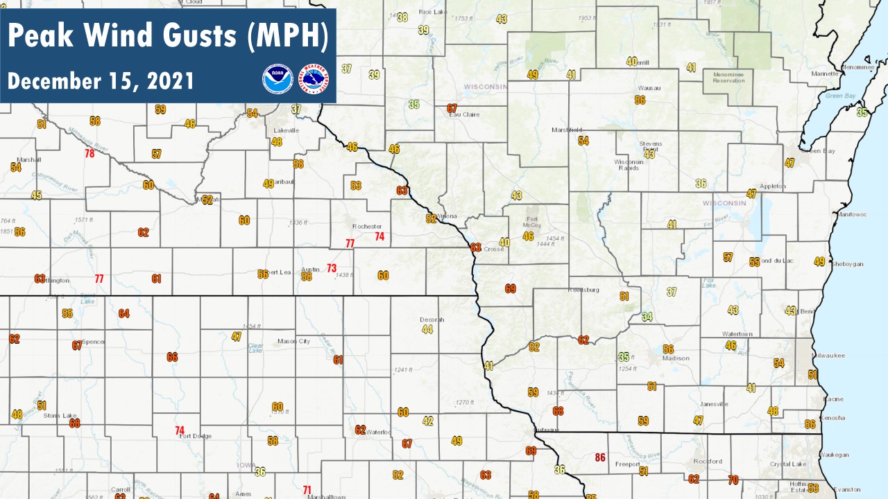
| Peak Gusts Across Central US - 12/15/2021 | Regional Peak Gusts - 12/15/2021 | Regional Peak Gusts - 12/16/2021 |
Highest Thunderstorm Wind Gusts (≥50 mph): December 15, 2021
Location                     Speed     Time/Date       Lat/Lon

...Iowa...

...Chickasaw County...
2 N Ionia                    63 MPH    0720 PM 12/15   43.07N/92.46W

...Clayton County...
Littleport                   50 MPH    0830 PM 12/15   42.75N/91.37W

...Floyd County...
Charles City Airport         55 MPH    0715 PM 12/15   43.07N/92.62W

...Minnesota...

...Dodge County...
2 E Kasson                   72 MPH    0745 PM 12/15   44.02N/92.71W
Dodge Center Airport         70 MPH    0742 PM 12/15   44.02N/92.84W
Hayfield                     50 MPH    0733 PM 12/15   43.89N/92.85W
3 S Claremont                50 MPH    0739 PM 12/15   44.00N/93.00W

...Fillmore County...
Harmony                      84 MPH    0745 PM 12/15   43.55N/92.01W
Mabel                        84 MPH    0758 PM 12/15   43.52N/91.77W
7 N Mabel                    63 MPH    0800 PM 12/15   43.72N/91.77W

...Mower County...
3 S Grand Meadow             83 MPH    0733 PM 12/15   43.66N/92.57W
Elkton                       79 MPH    0735 PM 12/15   43.66N/92.71W
1 ENE Dexter                 73 MPH    0735 PM 12/15   43.73N/92.68W
Austin Municipal Airport     60 MPH    0722 PM 12/15   43.67N/92.97W
1 WSW Le Roy                 59 MPH    0729 PM 12/15   43.51N/92.53W

...Olmsted County...
Rochester Int'l Airport      77 MPH    0745 PM 12/15   43.91N/92.50W
2 SSE Eyota                  74 MPH    0800 PM 12/15   43.96N/92.21W
Rochester                    60 MPH    0754 PM 12/15   44.01N/92.48W
4 ESE Douglas                57 MPH    0756 PM 12/15   44.09N/92.49W

...Wabasha County...
Plainview                    85 MPH    0810 PM 12/15   44.17N/92.17W  *Area's Highest Reported Thunderstorm Gust
1 SSE Kellogg                57 MPH    0820 PM 12/15   44.28N/91.99W

...Winona County...
Saint Charles                52 MPH    0802 PM 12/15   43.97N/92.06W

...Wisconsin...

...Buffalo County...
Buffalo                      50 MPH    0902 PM 12/15   44.23N/91.86W

...Clark County...
Longwood                     70 MPH    0915 PM 12/15   44.89N/90.60W

...Grant County...
Platteville Municipal Airpor 68 MPH    0955 PM 12/15   42.68N/90.43W
Bagley                       63 MPH    0903 PM 12/15   42.90N/91.10W
Dickeyville                  60 MPH    0934 PM 12/15   42.63N/90.59W
Lancaster RAWS               59 MPH    0932 PM 12/15   42.83N/90.69W
Boscobel Airport             51 MPH    0928 PM 12/15   43.16N/90.68W
Blue River                   50 MPH    0915 PM 12/15   43.19N/90.57W
Lancaster                    50 MPH    0920 PM 12/15   42.85N/90.71W

...La Crosse County...
La Crosse Regional Airport   54 MPH    0831 PM 12/15   43.87N/91.26W

...Monroe County...
Sparta/Fort McCoy Airport    56 MPH    0912 PM 12/15   43.97N/90.73W

...Richland County...
Lone Rock                    66 MPH    1002 PM 12/15   43.18N/90.20W
2 N Viola                    62 MPH    0932 PM 12/15   43.54N/90.67W

...Trempealeau County...
2 E Marshland                65 MPH    0826 PM 12/15   44.07N/91.51W

...Vernon County...
Viroqua Municipal Airport    69 MPH    0915 PM 12/15   43.56N/90.89W
5 S Viroqua                  62 MPH    0915 PM 12/15   43.49N/90.89W

Observations are collected from a variety of sources with varying
equipment and exposures. We thank all volunteer weather observers
for their dedication. Not all data listed are considered official.
Highest Non-Thunderstorm Wind Gusts (≥50 mph): December 15-16, 2021
Location                     Speed     Time/Date       Lat/Lon

...Iowa...

...Chickasaw County...
2 N Ionia                    63 MPH    1100 PM 12/15   43.07N/92.46W

...Fayette County...
Oelwein Municipal Airport    60 MPH    1135 PM 12/15   42.68N/91.97W

...Floyd County...
Charles City Airport         61 MPH    1055 PM 12/15   43.07N/92.62W

...Winneshiek County...
5 NW Frankville              58 MPH    0120 AM 12/16   43.25N/91.70W
Decorah Municipal Airport    51 MPH    1235 AM 12/16   43.27N/91.72W

...Minnesota...

...Dodge County...
2 E Kasson                   67 MPH    1150 PM 12/15   44.02N/92.71W
Dodge Center Airport         58 MPH    0135 AM 12/16   44.02N/92.82W

...Fillmore County...
Preston Airport              60 MPH    1135 PM 12/15   43.68N/92.17W

...Mower County...
Austin Municipal Airport     58 MPH    1115 PM 12/15   43.67N/92.92W
1 ENE Dexter                 58 MPH    1130 PM 12/15   43.73N/92.68W

...Olmsted County...
Rochester Int'l Airport      77 MPH    1125 PM 12/15   43.90N/92.50W  *Area's Highest Reported Non-Thunderstorm Gust
2 NNE Rochester              67 MPH    1030 PM 12/15   44.04N/92.46W
2 SSE Eyota                  66 MPH    1145 PM 12/15   43.96N/92.21W
3 N Stewartville             65 MPH    1205 AM 12/16   43.90N/92.48W
Mayo Helipad                 61 MPH    1155 PM 12/15   44.02N/92.48W
Rochester                    51 MPH    1125 PM 12/15   44.09N/92.49W

...Wabasha County...
1 SSE Kellogg                63 MPH    1150 PM 12/15   44.28N/91.99W
Lake City                    60 MPH    0145 AM 12/16   44.32N/92.44W

...Winona County...
Winona Municipal Airport     52 MPH    1155 PM 12/15   44.07N/91.70W

...Wisconsin...

...Grant County...
Platteville Municipal Airpor 60 MPH    0115 AM 12/16   42.68N/90.43W
Boscobel Airport             58 MPH    1138 PM 12/15   43.15N/90.68W
Lancaster RAWS               57 MPH    0141 AM 12/16   42.83N/90.69W
4 WSW Lancaster              55 MPH    0100 AM 12/16   42.83N/90.79W

...Juneau County...
Mauston Airport              58 MPH    1235 AM 12/16   43.83N/90.13W
Necedah RAWS                 53 MPH    1248 AM 12/16   44.03N/90.08W

...La Crosse County...
La Crosse Regional Airport   68 MPH    1236 AM 12/16   43.88N/91.25W
La Crosse RAWS               57 MPH    0208 AM 12/16   43.82N/91.19W
Onalaska                     55 MPH    1225 AM 12/16   43.89N/91.18W
La Crosse                    53 MPH    0108 AM 12/16   43.82N/91.19W
4 S La Crosse                51 MPH    0100 AM 12/16   43.77N/91.22W

...Monroe County...
Sparta/Fort McCoy Airport    54 MPH    0224 AM 12/16   43.97N/90.73W

...Richland County...
Lone Rock                    58 MPH    1018 PM 12/15   43.18N/90.20W

...Taylor County...
Medford Airport              53 MPH    0215 AM 12/16   45.10N/90.30W
Gilman                       51 MPH    0120 AM 12/16   45.17N/90.82W

...Vernon County...
Viroqua Municipal Airport    62 MPH    1155 PM 12/15   43.58N/90.90W

Observations are collected from a variety of sources with varying
equipment and exposures. We thank all volunteer weather observers
for their dedication. Not all data listed are considered official.
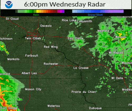
Radar:
 |
|||
| Reflectivity Radar Loop: 6 to 11 pm |
Environment:
 |
 |
 |
 |
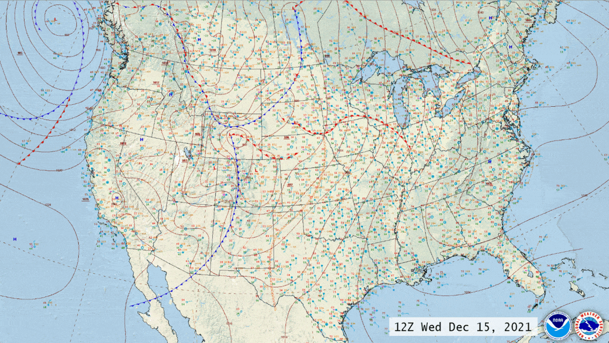
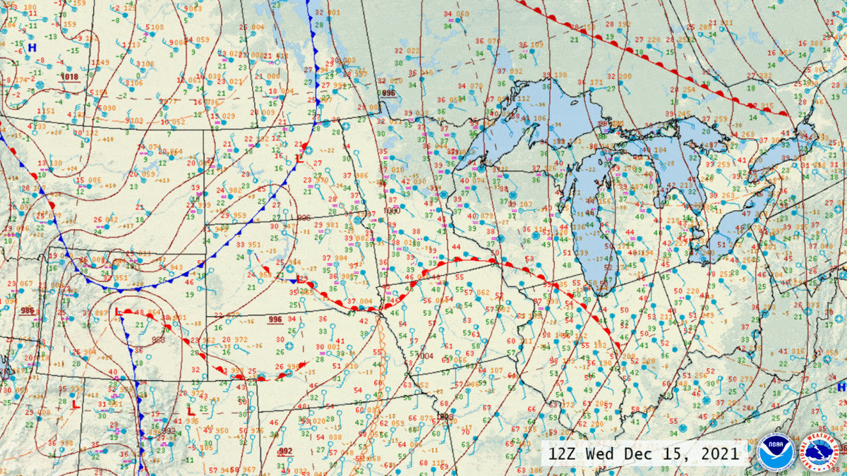
| Surface Analysis Loop December 15-16, 2021 |
Regional Surface Analysis Loop December 15-16, 2021 |
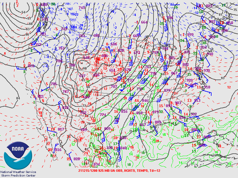
925 Millibar Analysis December 15, 2021 |
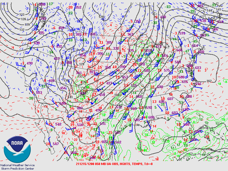
850 Millibar Analysis December 15, 2021 |
 |
 |
 |
 |
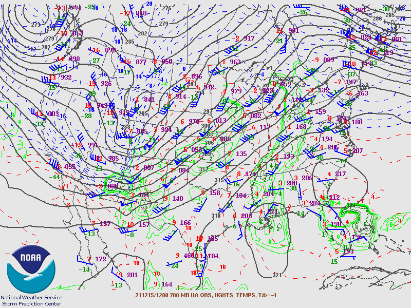
| 700 Millibar Analysis December 15, 2021 |
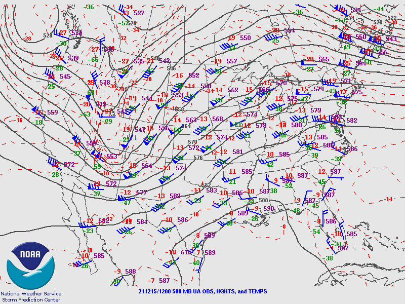
500 Millibar Analysis December 15, 2021 |
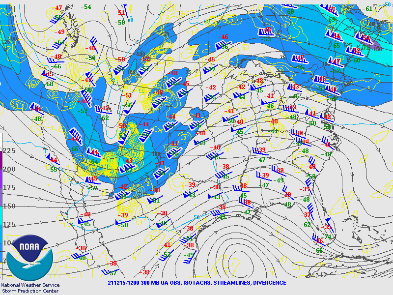
300 Millibar Analysis December 15, 2021 |
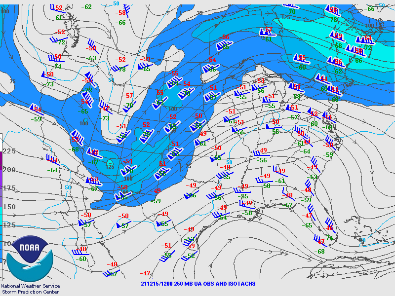
250 Millibar Analysis December 15, 2021 |
Record-Breaking Warmth:
 |
 |
|
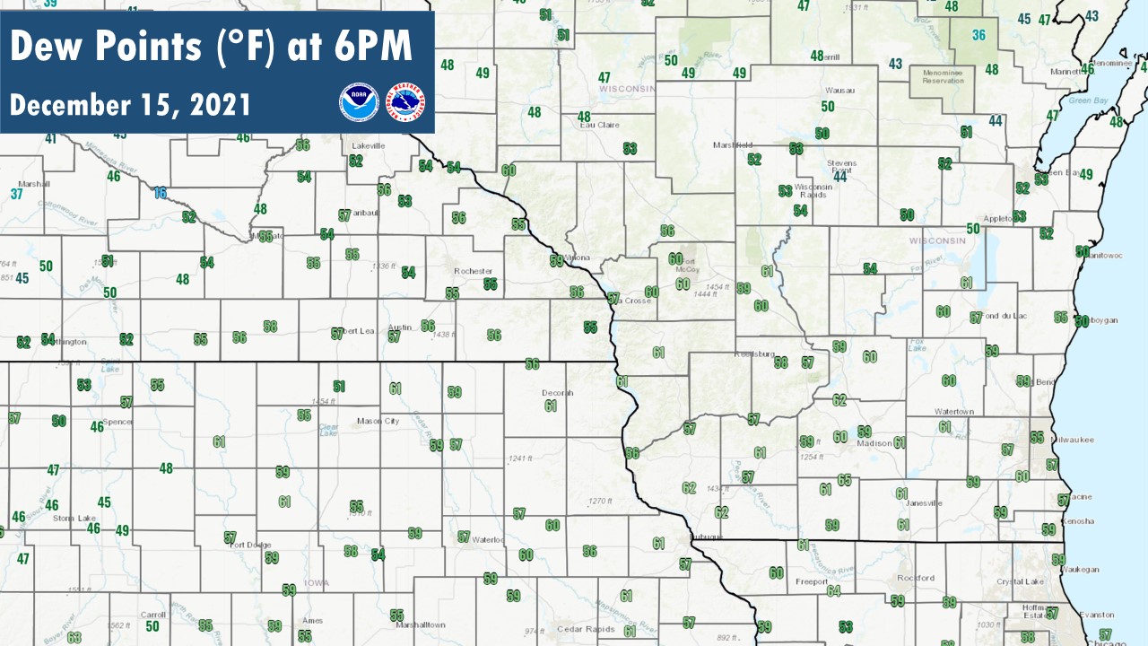
| Regional High Temperatures (preliminary) | Regional Early Evening Dewpoints in 50s/60s Prior to Thunderstorms Arriving |
Additional Info:
Event Summaries from Other Area NWS Offices
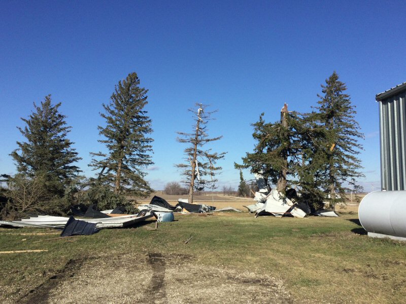
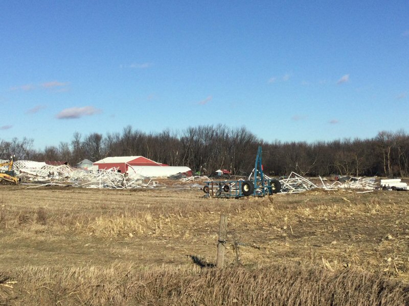
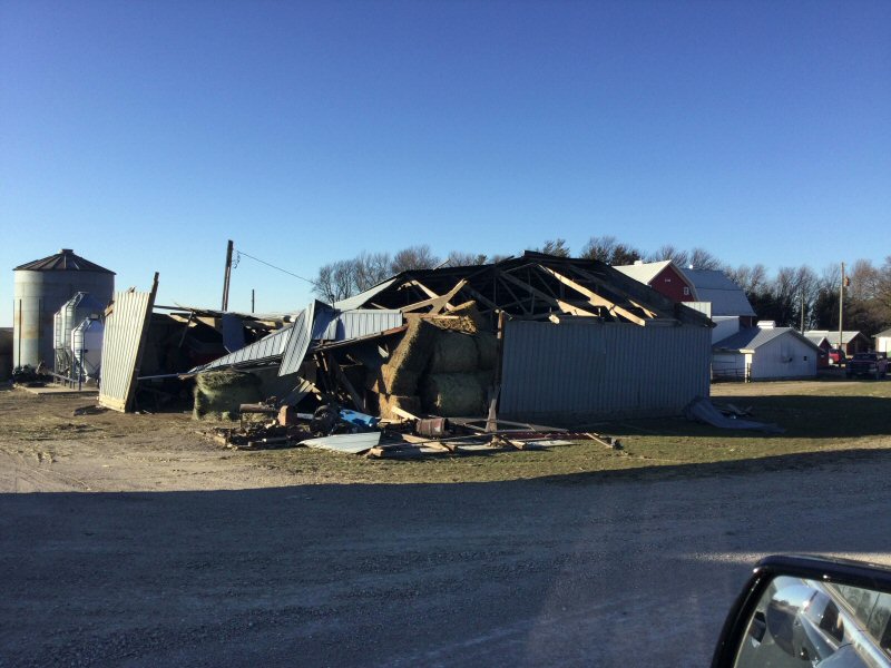
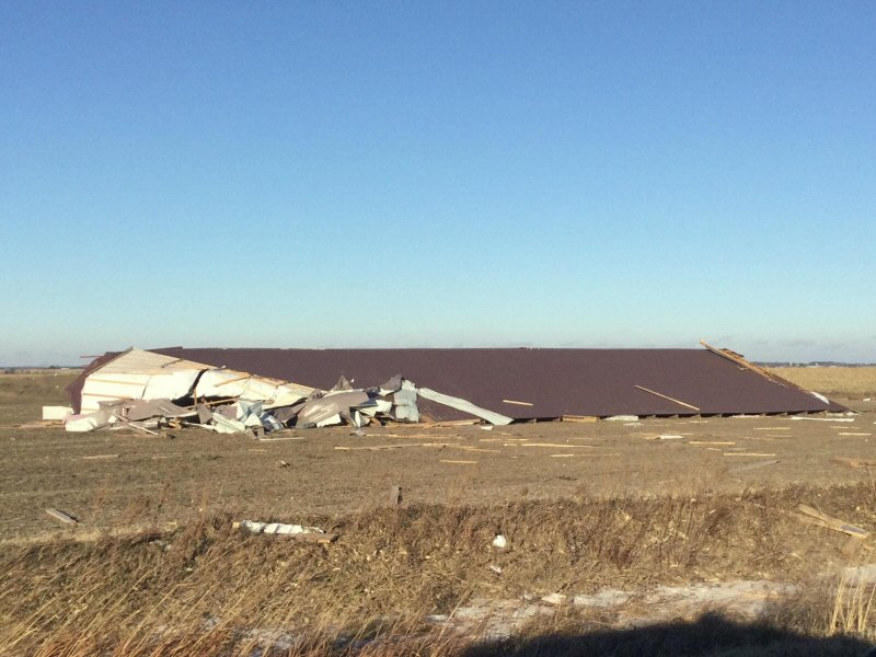
Photos:
Iowa
 |
 |
 |
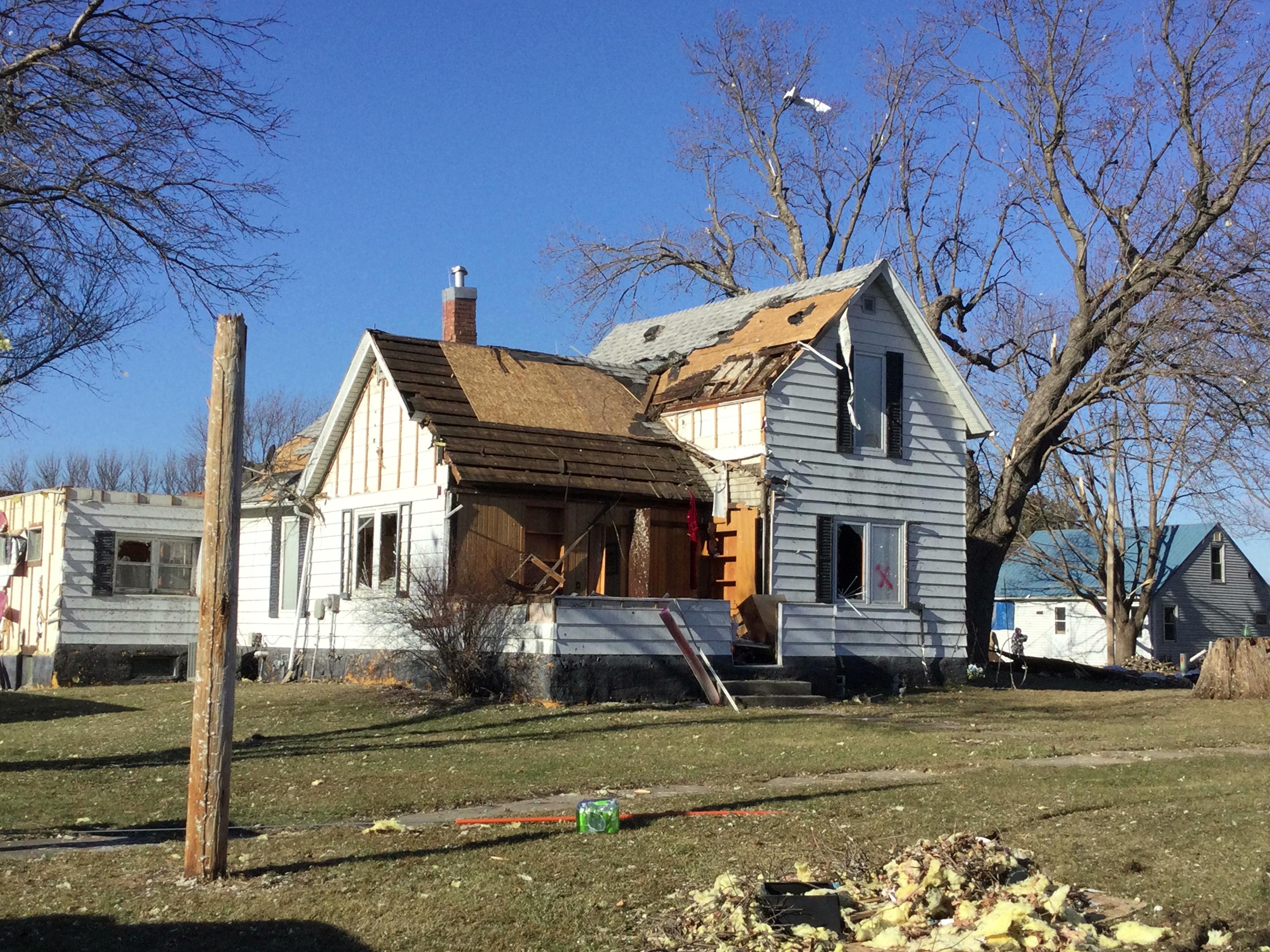 |
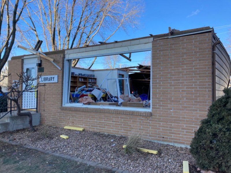
| City of Rudd Library (Chris Nelson) |
Rudd (NWS La Crosse) |
Rudd (NWS La Crosse) |
Rudd (NWS La Crosse) |
 |
 |
 |
 |
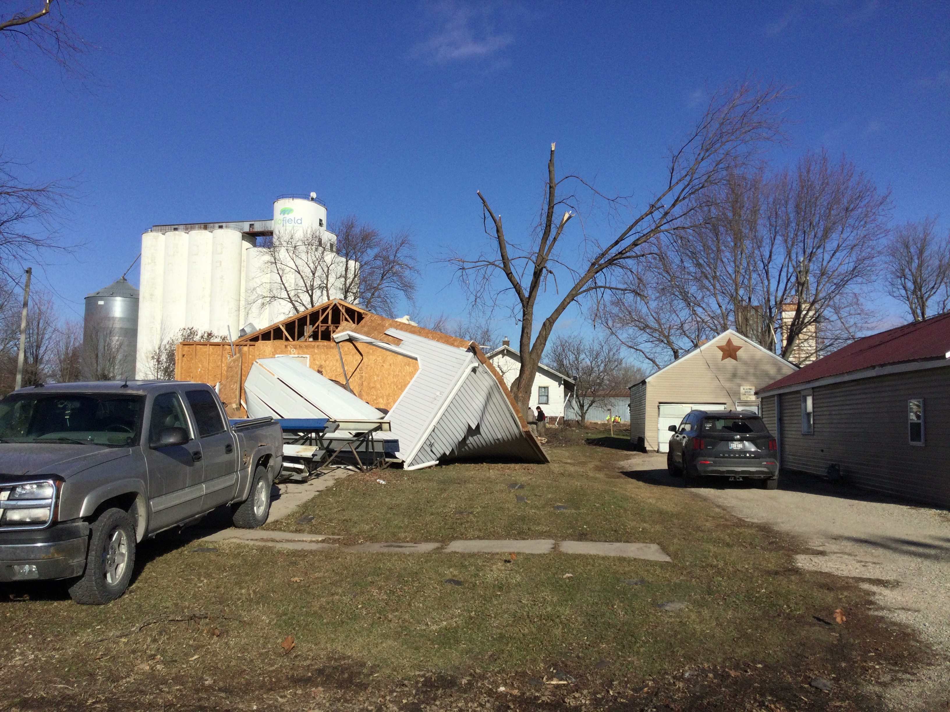
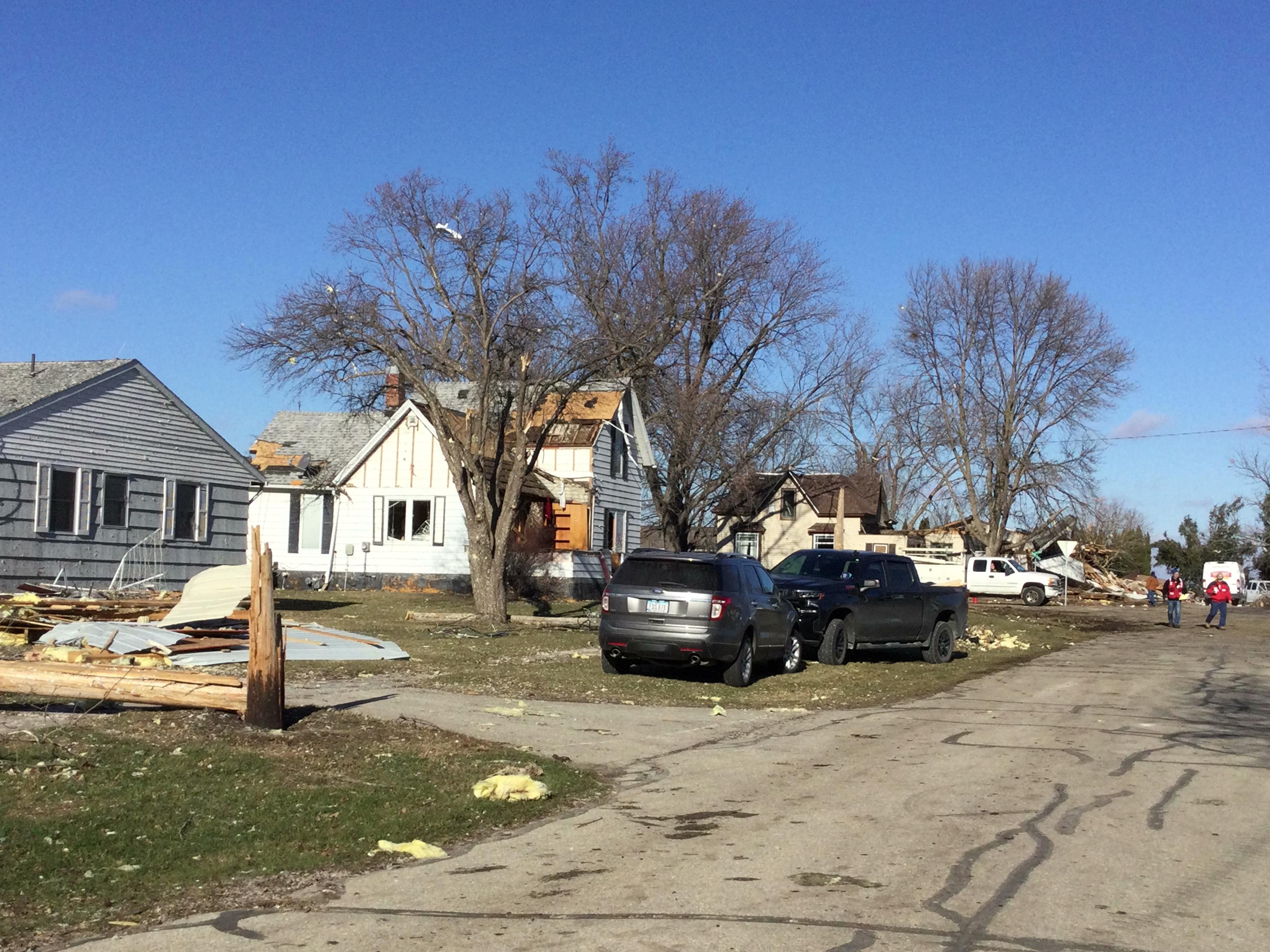
| Marble Rock (NWS La Crosse) |
Marble Rock (NWS La Crosse) |
Marble Rock (NWS La Crosse) |
Marble Rock (NWS La Crosse) |
 |
 |
 |
|
| Elma (NWS La Crosse) |
Maple Leaf (NWS La Crosse) |
Schley (NWS La Crosse) |
Minnesota
 |
 |
 |
 |
| Grand Meadow (Ryan Knapp) |
Plainview (Aaron White) |
Wyattville (NWS La Crosse) |
Wyattville (NWS La Crosse) |
Wisconsin
 |
 |
 |
|
| Coral City (Trempealeau Co EM) |
Wade Rd. Trempealeau Co. (Trempealeau Co EM) |
La Crosse - Cass St. (Todd Rieck) |
 |
 |
 |
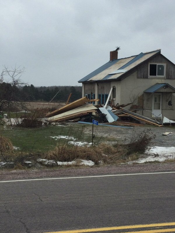 |
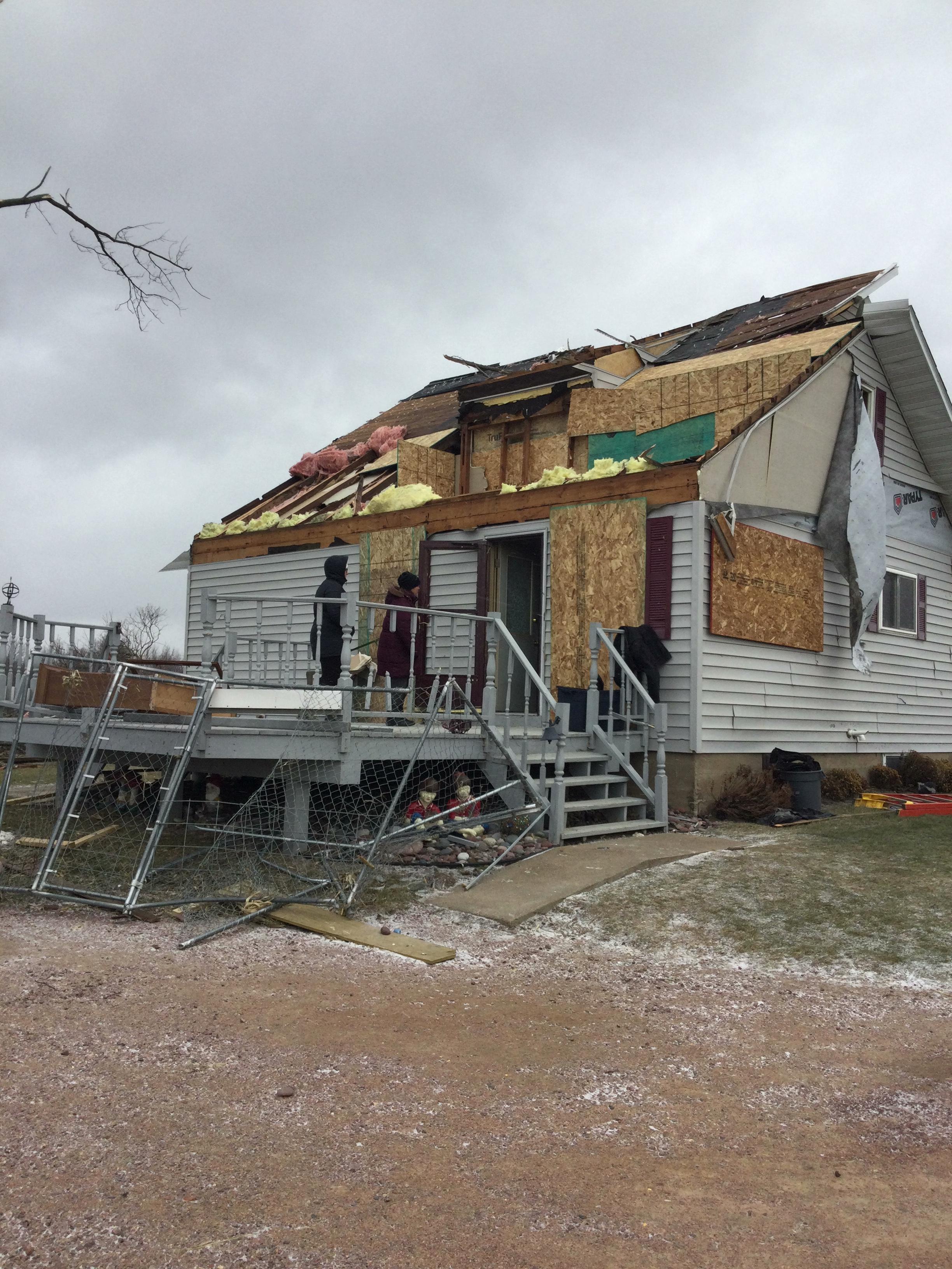
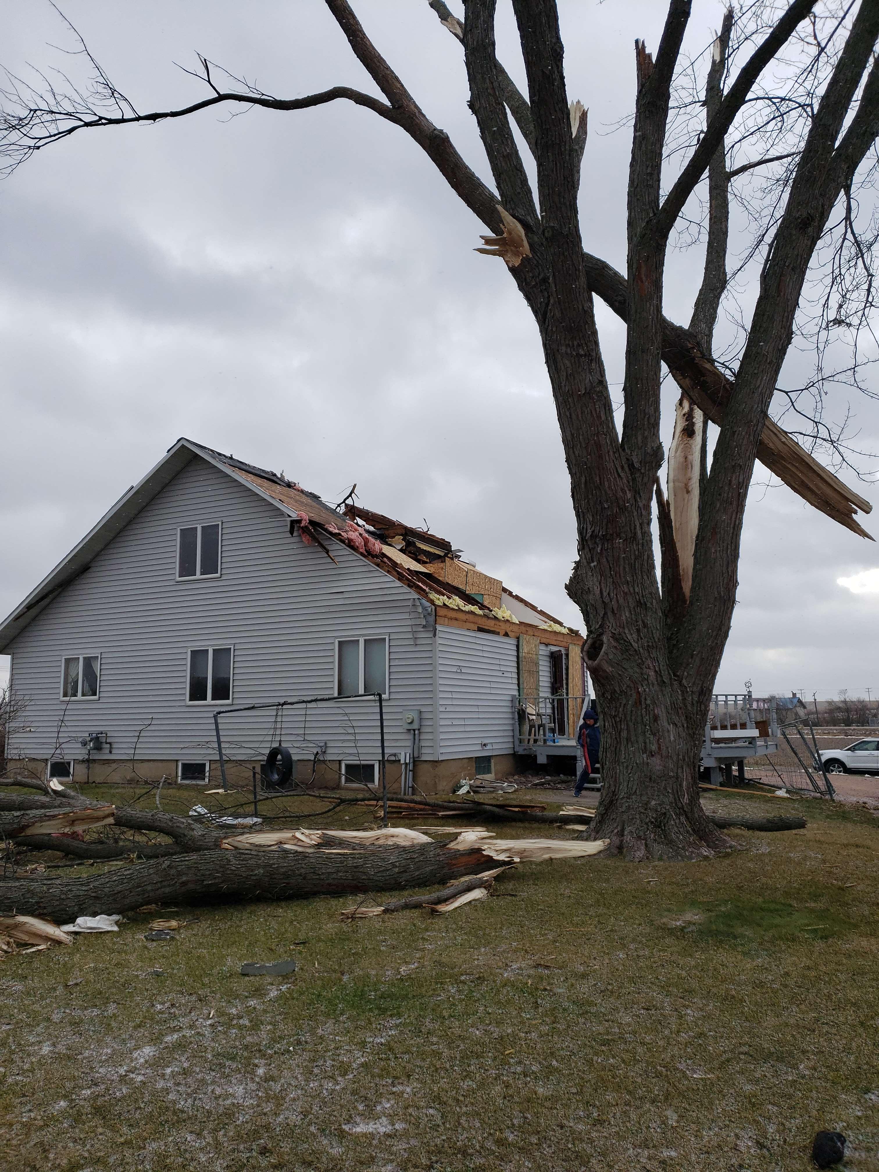
| Southwest of Neillsville (NWS La Crosse) |
Southwest of Neillsville (NWS La Crosse) |
Southwest of Neillsville (NWS La Crosse) |
North of Neillsville (NWS La Crosse) |
 |
 |
||
| North of Neillsville, along Highway 73 (NWS La Crosse) |
North of Neillsville, along Highway 73 (NWS La Crosse) |
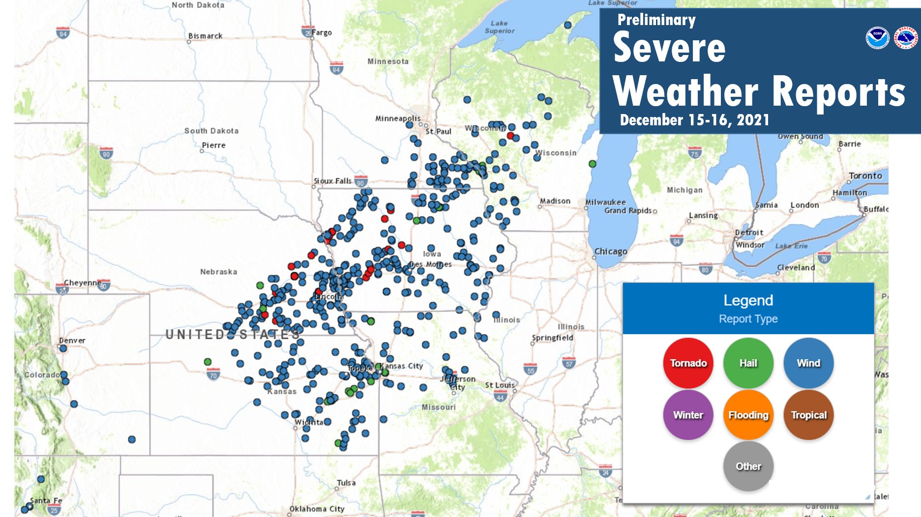
Storm Reports from Thunderstorms:
 |
 |
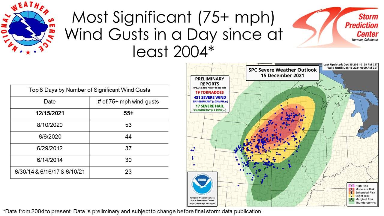 |
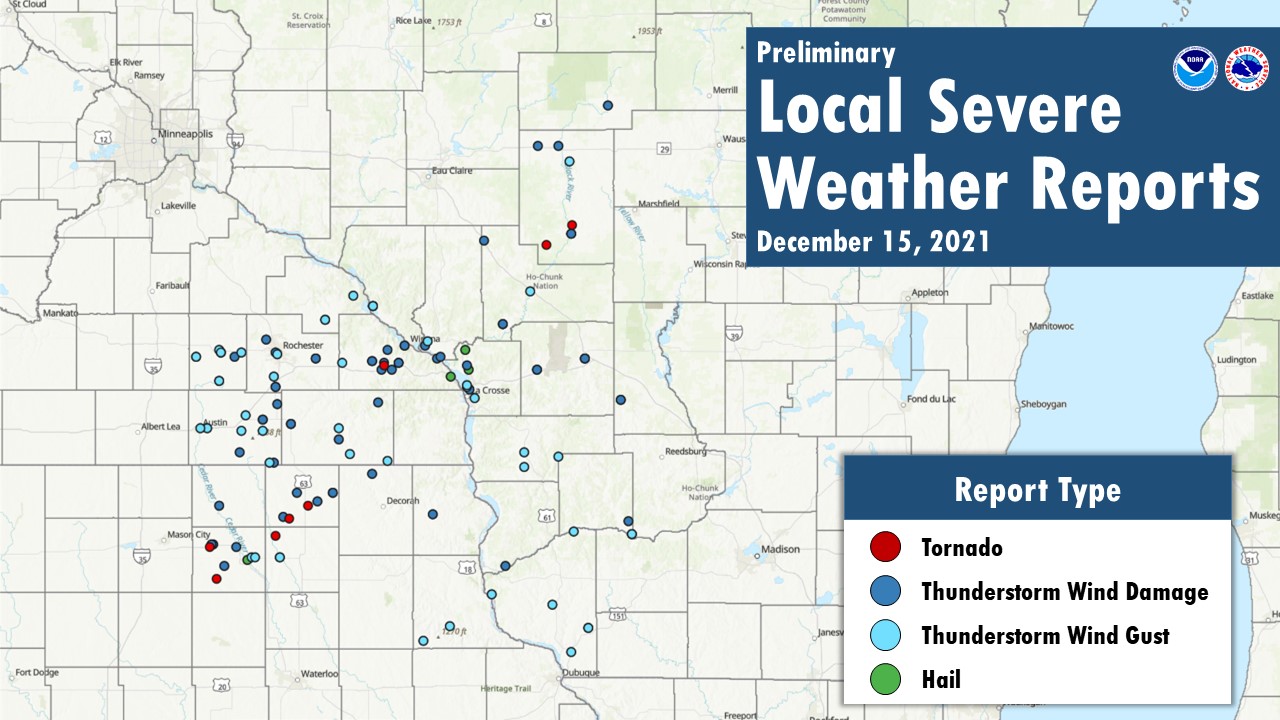
| Regional Severe Weather Reports | Local Severe Weather Reports | Record Breaking Number of Significant Thunderstorm Gusts (courtesy SPC) |
PRELIMINARY LOCAL STORM REPORT...SUMMARY
NATIONAL WEATHER SERVICE LA CROSSE WI
427 AM CST THU DEC 16 2021
..TIME... ...EVENT... ...CITY LOCATION... ...LAT.LON...
..DATE... ....MAG.... ..COUNTY LOCATION..ST.. ...SOURCE....
..REMARKS..
0700 PM TSTM WND DMG FLOYD 43.12N 92.74W
12/15/2021 FLOYD IA PUBLIC
OVERTURNED SEMI-TRUCK TRAILER AT TRUCK STOP.
0700 PM TSTM WND DMG 5 NNE MARBLE ROCK 43.03N 92.82W
12/15/2021 FLOYD IA FIRE DEPT/RESCUE
NUMEROUS REPORTS OF WIND DAMAGE TO HOUSES.
0700 PM TSTM WND DMG 1 E RUDD 43.13N 92.89W
12/15/2021 FLOYD IA FIRE DEPT/RESCUE
ROOF ON HWY 27 NEAR PARK ENTRANCE.
0706 PM TSTM WND DMG 1 SE MITCHELL 43.31N 92.85W
12/15/2021 MITCHELL IA EMERGENCY MNGR
REPORTS OF FLATTENED FARM BUILDINGS.
0709 PM HAIL CHARLES CITY 43.06N 92.67W
12/15/2021 E1.00 INCH FLOYD IA FIRE DEPT/RESCUE
NICKEL TO QUARTER SIZED HAIL REPORTED.
0715 PM TSTM WND GST 3 E CHARLES CITY 43.07N 92.62W
12/15/2021 M55 MPH FLOYD IA AWOS
AWOS STATION KCCY CHARLES CITY AIRPORT.
0715 PM TSTM WND DMG RUDD 43.13N 92.90W
12/15/2021 FLOYD IA PUBLIC
DAMAGE TO RAILROAD TRACKS.
0720 PM TSTM WND GST 2 N IONIA 43.07N 92.46W
12/15/2021 M63 MPH CHICKASAW IA MESONET
IOWA DOT SENSOR.
0720 PM TSTM WND DMG 1 N ELMA 43.26N 92.44W
12/15/2021 HOWARD IA PUBLIC
REPORT FROM MPING: TREES UPROOTED OR
SNAPPED; ROOF BLOWN OFF.
0722 PM TSTM WND GST 1 SE DODGE CENTER 44.02N 92.84W
12/15/2021 M70 MPH DODGE MN PUBLIC
0722 PM TSTM WND GST 2 ESE AUSTIN 43.67N 92.93W
12/15/2021 M60 MPH MOWER MN AWOS
AUTOMATED WEATHER OBSERVATION FROM THE
AUSTIN AIRPORT.
0727 PM TSTM WND DMG ADAMS 43.56N 92.72W
12/15/2021 MOWER MN PUBLIC
DAMAGE TO BARN/OUTBUILDING. REPORT VIA KAAL,
TIMING BASED ON RADAR.
0729 PM TSTM WND GST 1 W LE ROY 43.51N 92.53W
12/15/2021 E59 MPH MOWER MN AMATEUR RADIO
0730 PM TSTM WND DMG 4 WSW VERNON SPRINGS 43.33N 92.22W
12/15/2021 HOWARD IA TRAINED SPOTTER
MAJOR DAMAGE SUSTAINED BY LARGE OUTBUILDING
SOUTHWEST OF CRESCO. ALSO MAJOR STRUCTURAL
DAMAGE AT A NEARBY HOG FARM. TIME ESTIMATED
FROM RADAR.
0733 PM TSTM WND GST 3 S GRAND MEADOW 43.66N 92.57W
12/15/2021 M83 MPH MOWER MN TRAINED SPOTTER
0733 PM TSTM WND GST HAYFIELD 43.89N 92.85W
12/15/2021 E50 MPH DODGE MN EMERGENCY MNGR
RELAYED FROM SPOTTERS.
0735 PM TSTM WND GST ELKTON 43.66N 92.71W
12/15/2021 E79 MPH MOWER MN BROADCAST MEDIA
0735 PM TSTM WND GST 1 ENE DEXTER 43.73N 92.68W
12/15/2021 M73 MPH MOWER MN MESONET
MESONET STATION MN010 1 ENE DEXTER.
0736 PM TSTM WND DMG STEWARTVILLE 43.86N 92.49W
12/15/2021 OLMSTED MN EMERGENCY MNGR
REPORTS OF POWER OUTAGES.
0737 PM TSTM WND DMG CRESCO 43.37N 92.12W
12/15/2021 HOWARD IA TRAINED SPOTTER
POWER OUTAGES REPORTED.
0739 PM TSTM WND GST 3 S CLAREMONT 44.00N 93.00W
12/15/2021 E50 MPH DODGE MN EMERGENCY MNGR
ROAD SIGNS DAMAGED.
0742 PM TSTM WND GST 1 SE DODGE CENTER 44.02N 92.84W
12/15/2021 M70 MPH DODGE MN AWOS
CORRECTS PREVIOUS TSTM WND GST REPORT FROM 1
SE DODGE CENTER.
0744 PM FUNNEL CLOUD 1 S HARMONY 43.54N 92.01W
12/15/2021 FILLMORE MN TRAINED SPOTTER
0745 PM TSTM WND GST HARMONY 43.55N 92.01W
12/15/2021 M84 MPH FILLMORE MN PUBLIC
0745 PM TSTM WND GST ROCHESTER AIRPORT 43.91N 92.50W
12/15/2021 M77 MPH OLMSTED MN ASOS
0745 PM TSTM WND GST 2 ESE KASSON 44.02N 92.71W
12/15/2021 M72 MPH DODGE MN MESONET
MESONET STATION MN029 2 E KASSON.
0746 PM TSTM WND GST PRESTON 43.67N 92.08W
12/15/2021 M47 MPH FILLMORE MN AWOS
0748 PM TSTM WND DMG 2 SE DOUGLAS 44.08N 92.55W
12/15/2021 OLMSTED MN PUBLIC
0750 PM TSTM WND DMG SPRING VALLEY 43.69N 92.39W
12/15/2021 FILLMORE MN AMATEUR RADIO
REPORTS OF WIDESPREAD POWER OUTAGES.
0753 PM TSTM WND DMG 1 WNW ROCHESTER 44.02N 92.49W
12/15/2021 OLMSTED MN PUBLIC
REPORT FROM MPING: TREES UPROOTED OR
SNAPPED; ROOF BLOWN OFF.
0754 PM TSTM WND GST ROCHESTER 44.01N 92.48W
12/15/2021 E60 MPH OLMSTED MN TRAINED SPOTTER
0758 PM TSTM WND GST MABEL 43.52N 91.77W
12/15/2021 M84 MPH FILLMORE MN PUBLIC
0800 PM TSTM WND GST 7 N MABEL 43.72N 91.77W
12/15/2021 M63 MPH FILLMORE MN PUBLIC
0802 PM TSTM WND GST ST. CHARLES 43.97N 92.06W
12/15/2021 E52 MPH WINONA MN TRAINED SPOTTER
0805 PM TSTM WND DMG 4 ESE LEWISTON 43.97N 91.79W
12/15/2021 WINONA MN COUNTY OFFICIAL
SIGNIFICANT HOUSE DAMAGE.
0808 PM FUNNEL CLOUD 6 N NODINE 43.99N 91.45W
12/15/2021 WINONA MN PARK/FOREST SRVC
FUNNEL CLOUD VISUAL NEAR THE MISSISSIPPI
RIVER.
0809 PM TSTM WND DMG 4 SE LEWISTON 43.94N 91.81W
12/15/2021 WINONA MN EMERGENCY MNGR
BUILDINGS DAMAGED ALONG COUNTY HIGHWAY 25.
TIME ESTIMATED.
0810 PM TSTM WND GST PLAINVIEW 44.17N 92.17W
12/15/2021 M85 MPH WABASHA MN PUBLIC
0810 PM TSTM WND DMG LEWISTON 43.98N 91.87W
12/15/2021 WINONA MN EMERGENCY MNGR
POWER OUTAGES REPORTED.
0810 PM TSTM WND DMG PETERSON 43.79N 91.83W
12/15/2021 FILLMORE MN PUBLIC
MATURE, LARGE PINE TREE DOWN REPORT VIA
MEDIA ON TWITTER.
0816 PM TSTM WND DMG 3 WSW WILSON 43.94N 91.74W
12/15/2021 WINONA MN PUBLIC
POWER POLE BROKEN.
0817 PM TSTM WND GST FRENCH ISLAND 43.86N 91.26W
12/15/2021 M52 MPH LA CROSSE WI ASOS
0818 PM TSTM WND DMG 6 SSW WINONA 43.97N 91.70W
12/15/2021 WINONA MN EMERGENCY MNGR
SEMI TRUCK BLOWN OVER AT INTERSTATE 90 MILE
MARKER 252.
0820 PM TSTM WND GST 2 SSE KELLOGG 44.28N 91.99W
12/15/2021 M57 MPH WABASHA MN MESONET
MESONET STATION MN069 1 SSE KELLOGG.
0820 PM TSTM WND DMG HOLMEN 43.96N 91.26W
12/15/2021 LA CROSSE WI COUNTY OFFICIAL
POWER LINES DOWN.
0821 PM TSTM WND DMG 6 N NODINE 43.99N 91.45W
12/15/2021 WINONA MN PUBLIC
POWER OUTAGES REPORTED.
0822 PM TSTM WND GST BUFFALO 44.23N 91.86W
12/15/2021 M50 MPH BUFFALO WI PUBLIC
CORRECTS PREVIOUS TSTM WND GST REPORT FROM
BUFFALO.
0823 PM TSTM WND DMG WAUKON 43.27N 91.48W
12/15/2021 ALLAMAKEE IA PUBLIC
TREE DOWN. TIME ESTIMATED FROM RADAR.
0825 PM HAIL DAKOTA 43.91N 91.36W
12/15/2021 M0.75 INCH WINONA MN EMERGENCY MNGR
0825 PM TSTM WND DMG 4 NNE BLUFFTON 43.46N 91.87W
12/15/2021 WINNESHIEK IA LAW ENFORCEMENT
MULTIPLE TREES DOWN.
0826 PM TSTM WND GST 2 E MARSHLAND 44.07N 91.51W
12/15/2021 M65 MPH TREMPEALEAU WI MESONET
MESONET STATION FW3090 TREMPEALEAU.
0826 PM TSTM WND DMG WINONA 44.05N 91.66W
12/15/2021 WINONA MN EMERGENCY MNGR
POWER OUTAGES IN NUMEROUS COMMUNITIES.
0829 PM TSTM WND DMG 1 SE FRENCH ISLAND 43.85N 91.24W
12/15/2021 LA CROSSE WI PUBLIC
0830 PM TSTM WND GST LITTLEPORT 42.75N 91.37W
12/15/2021 E50 MPH CLAYTON IA FIRE DEPT/RESCUE
0830 PM HAIL 4 NE NEW AMSTERDAM 44.03N 91.27W
12/15/2021 E1.25 INCH LA CROSSE WI NWS EMPLOYEE
0831 PM TSTM WND GST LA CROSSE AIRPORT 43.87N 91.26W
12/15/2021 M54 MPH LA CROSSE WI ASOS
0832 PM HAIL 2 S HOLMEN 43.94N 91.25W
12/15/2021 E0.25 INCH LA CROSSE WI PUBLIC
0834 PM TSTM WND GST 2 E LA CROSSE 43.81N 91.21W
12/15/2021 M48 MPH LA CROSSE WI OFFICIAL NWS OBS
0841 PM TSTM WND GST STRAWBERRY POINT 42.68N 91.54W
12/15/2021 M48 MPH CLAYTON IA EMERGENCY MNGR
SUSTAINED WINDS.
0845 PM TSTM WND DMG BUFFALO 44.23N 91.86W
12/15/2021 BUFFALO WI PUBLIC
REPORTS OF FEW TREES DOWN IN TOWN.
0847 PM TSTM WND DMG TREMPEALEAU 44.00N 91.43W
12/15/2021 TREMPEALEAU WI COUNTY OFFICIAL
REPORTS OF TREES DOWN WITHIN TOWN.
0851 PM TSTM WND DMG 2 NW MELROSE 44.15N 91.03W
12/15/2021 JACKSON WI EMERGENCY MNGR
HOUSE DAMAGED.
0851 PM TSTM WND DMG 5 SE OSSEO 44.53N 91.15W
12/15/2021 JACKSON WI PUBLIC
TREES DOWN.
0855 PM TSTM WND GST BLACK RIVER FALLS 44.30N 90.85W
12/15/2021 M43 MPH JACKSON WI AWOS
0902 PM TSTM WND GST BUFFALO 44.23N 91.86W
12/15/2021 M50 MPH BUFFALO WI PUBLIC
.
0903 PM TSTM WND GST BAGLEY 42.90N 91.10W
12/15/2021 E63 MPH GRANT WI FIRE DEPT/RESCUE
0911 PM TSTM WND DMG SPARTA 43.94N 90.81W
12/15/2021 MONROE WI EMERGENCY MNGR
DOOR OVERHANDS DAMAGED.
0912 PM TSTM WND DMG 3 NE BRIDGEPORT 43.03N 91.01W
12/15/2021 CRAWFORD WI PUBLIC
0914 PM TSTM WND DMG GRAND MEADOW 43.71N 92.57W
12/15/2021 MOWER MN PUBLIC
0915 PM TSTM WND GST LONGWOOD 44.89N 90.60W
12/15/2021 M70 MPH CLARK WI PUBLIC
0915 PM TSTM WND GST VIROQUA 43.56N 90.89W
12/15/2021 M69 MPH VERNON WI AWOS
0915 PM TSTM WND GST 5 S VIROQUA 43.49N 90.89W
12/15/2021 M62 MPH VERNON WI PUBLIC
0915 PM TSTM WND GST BLUE RIVER 43.19N 90.57W
12/15/2021 E50 MPH GRANT WI FIRE DEPT/RESCUE
0915 PM FUNNEL CLOUD 6 N CHILI 44.71N 90.34W
12/15/2021 CLARK WI TRAINED SPOTTER
0919 PM TSTM WND DMG THORP 44.96N 90.80W
12/15/2021 CLARK WI PUBLIC
WINDOWS BLOWN OUT, ROOFS REMOVED FROM SHEDS.
0920 PM TSTM WND GST LANCASTER 42.85N 90.71W
12/15/2021 E50 MPH GRANT WI EMERGENCY MNGR
0921 PM TSTM WND DMG NEILLSVILLE 44.56N 90.59W
12/15/2021 CLARK WI PUBLIC
POWER LINES ACROSS ROAD, TREE DAMAGE, DEBRIS
FROM DAMAGED ROOF.
0924 PM TSTM WND DMG NEILLSVILLE 44.56N 90.59W
12/15/2021 CLARK WI PUBLIC
TREES AND POWER LINES DOWN ACROSS ROADS,
DEBRIS FROM DAMAGE ROOF.
0928 PM TSTM WND DMG TOMAH 43.99N 90.50W
12/15/2021 MONROE WI EMERGENCY MNGR
MULTIPLE LARGE TREES WERE UPROOTED AND FELL
ON STRUCTURES AND VEHICLES IN TOMAH. ONE
CAUSED A GAS LINE RUPTURE. MANY OTHER
REPORTS OF TREES AND POWER LINES DOWN ACROSS
THE COUNTY.
0930 PM TSTM WND DMG TOMAH 43.99N 90.50W
12/15/2021 MONROE WI EMERGENCY MNGR
POWER LINES BLOWN DOWN.
0932 PM TSTM WND GST 2 N VIOLA 43.54N 90.67W
12/15/2021 M62 MPH RICHLAND WI PUBLIC
0934 PM TSTM WND GST DICKEYVILLE 42.63N 90.59W
12/15/2021 E60 MPH GRANT WI EMERGENCY MNGR
0935 PM TSTM WND GST PLATTEVILLE 42.74N 90.48W
12/15/2021 M60 MPH GRANT WI AWOS
0944 PM TSTM WND DMG 4 N ELROY 43.80N 90.27W
12/15/2021 JUNEAU WI EMERGENCY MNGR
SEVERAL TREES BLOWN DOWN.
0950 PM TSTM WND DMG MEDFORD 45.14N 90.35W
12/15/2021 TAYLOR WI LAW ENFORCEMENT
MANY TREES AND POWER LINES REPORTED DOWN
ACROSS THE COUNTY, ESPECIALLY THE SOUTHERN
HALF.
0955 PM TSTM WND GST PLATTEVILLE 42.74N 90.48W
12/15/2021 M68 MPH GRANT WI AWOS
1002 PM TSTM WND GST LONE ROCK 43.18N 90.20W
12/15/2021 M66 MPH RICHLAND WI ASOS
CORRECTS PREVIOUS TSTM WND GST REPORT FROM
LONE ROCK.
1006 PM TSTM WND DMG 3 W WITHEE 44.96N 90.67W
12/15/2021 CLARK WI PUBLIC
REPORT FROM MPING: HOMES/BUILDINGS
COMPLETELY DESTROYED.
1105 PM TSTM WND DMG 4 E GOTHAM 43.24N 90.22W
12/15/2021 RICHLAND WI PUBLIC
REPORT FROM MPING: 3-INCH TREE LIMBS BROKEN;
POWER POLES BROKEN.
&&
NWS Messaging:
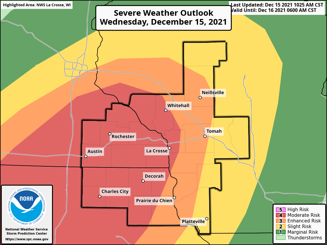
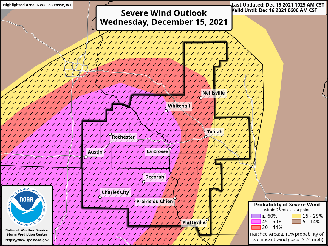
Storm Prediction Center Convective Outlooks
 |
 |
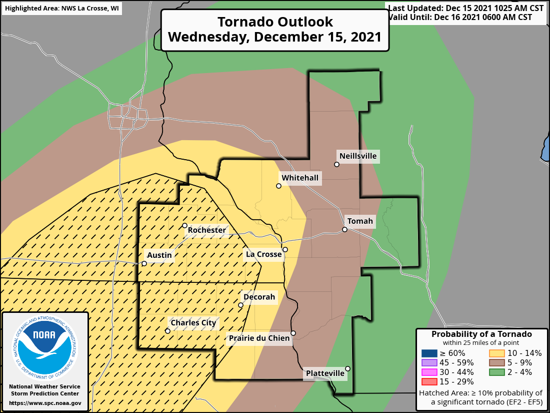 |
| Day 1 Outlook | Day 1 Wind | Day 1 Tornado |
Watches and Warnings
 |
 |
 |
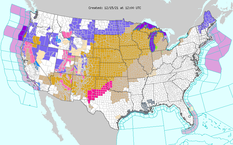
| High Wind Warnings & Wind Advisories Blanketed the Central US |
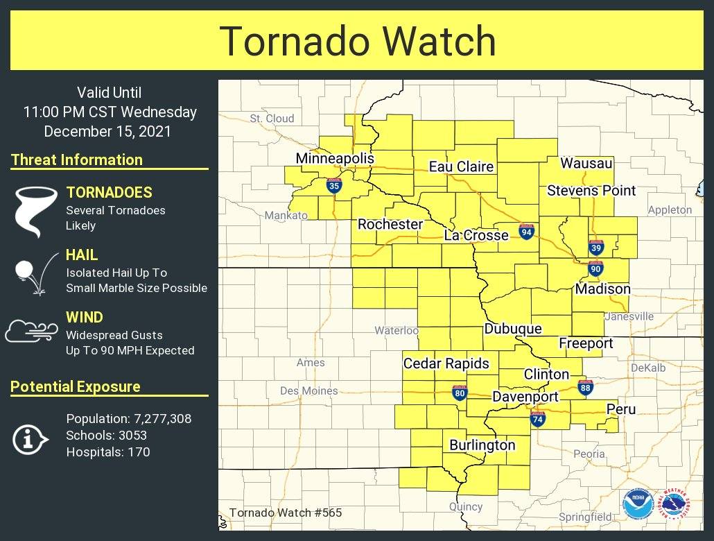
Local Tornado Watch First Ever December Tornado OR Severe Thunderstorm Watch for MN and WI! |
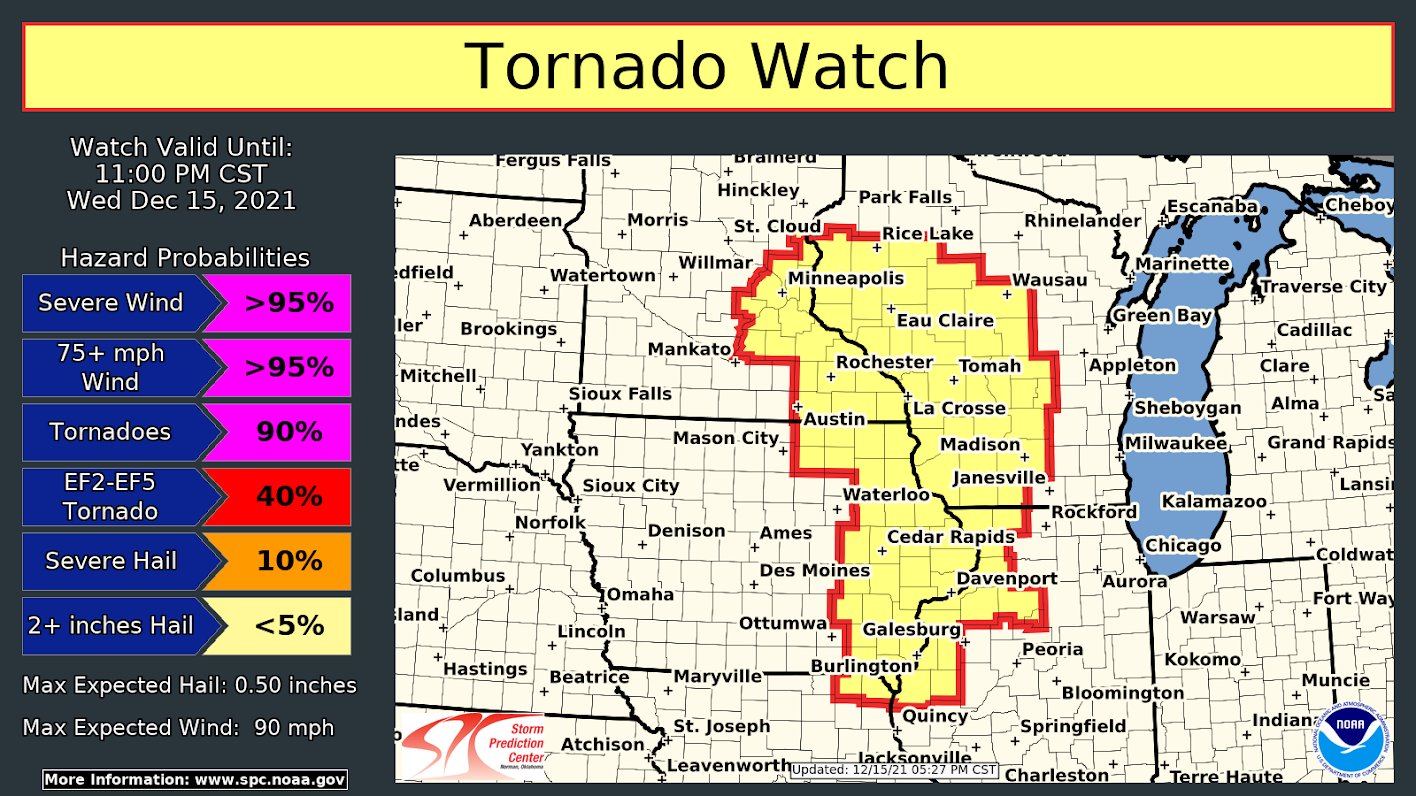
SPC Tornado Watch #565 with Hazard Probabilities |
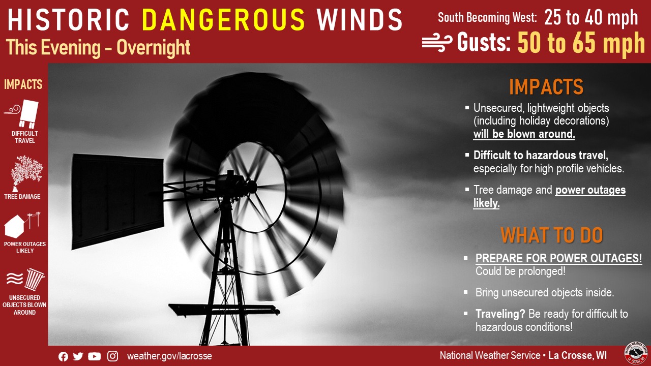
NWS La Crosse Weather Story Graphics
 |
 |
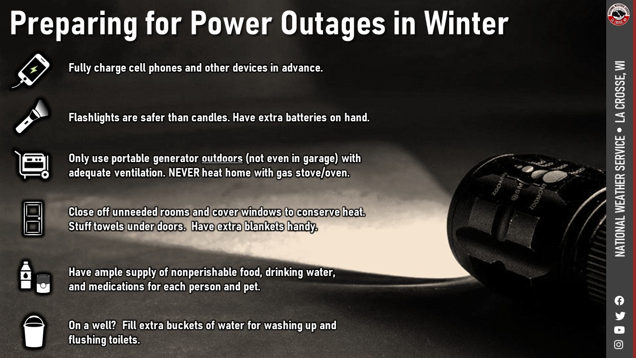 |
| Severe Weather Graphic | Dangerous Wind Graphic | Power Outage Preparations |
 |
Media use of NWS Web News Stories is encouraged! Please acknowledge the NWS as the source of any news information accessed from this site. |
|


 Weather Story
 Weather Map
 Local Radar