There are no watches, warnings, or advisories at this time.
Tonight
Isolated Severe Storm Possible This Weekend
Elevated Heat
Weather of the Week
Schertz Training
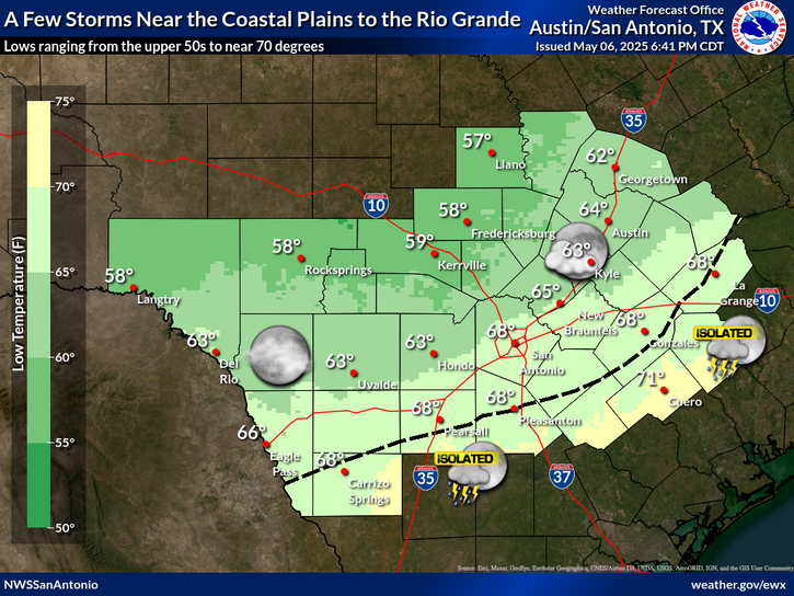
Warm and humid tonight with lows in the upper 60s and low 70s. Partly cloudy skies this evening will trend toward overcast by Sunday morning. Patchy fog is expected across portions of the Coastal Plains. Winds remain light from the south-southeast at 5 to 10 mph.
An isolated strong to severe storm is possible late this afternoon/evening, and again for late Sunday afternoon/evening. A Level 1 of 5 (Marginal) risk is in place for both days, primarily focused on the central and western portions of South-Central Texas (including the Hill Country, southern Edwards Plateau, and Rio Grande). Hazards include large hail, damaging winds, and lightning. Stay weather aware and have multiple ways to receive warnings!
Heat risk will be moderate to major through midweek as high humidity keeps afternoon heat indices elevated. Heat index values will peak on Tuesday, reaching up to 105°F in San Antonio and Austin, and 106°F in Eagle Pass. Safety remains a priority: drink plenty of water and limit strenuous outdoor activities.
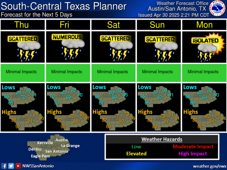
Conditions remain warm and humid through midweek. However, a cooling trend begins late week, with highs dropping into the 70s and 80s by next weekend. Rain chances are low early in the week but increase to medium chances (30–50%) for Thursday and Friday.
This training is sponsored by the National Weather Service and City of Schertz Office of Emergency Management. This will be an in person training session and is free and open to the public. No registration is required.
Time: 630 PM - 830 PM.
Training Overview: The training provides a basic overview of severe weather hazards and flooding. The training will include severe weather information specific to South Central Texas, procedures for spotting and reporting severe weather and flooding to local NWS forecasters, and how to stay weather aware and prepared.
Location:
Schertz Civic Center - Bluebonnet Hall
Building 5
1400 Schertz Parkway
Schertz, TX 78154


 Austin/San Antonio Radar
 Weather Map
 Satellite Imagery
 Del Rio Radar
 Digital Forecast Map
 Tropical Outlook
 Drought Status
 Air Quality
 Fire Weather Forecasts
 Observed Rainfall
 Observed Temperatures
 Daily Climate Graphs