National Weather Service United States Department of Commerce

Strong to Severe Thunderstorms May Bring Excessive Rainfall to the Southern U.S. Saturday

Marginally severe thunderstorms capable of strong wind gusts and hail will be possible Saturday across much of central Texas, and during the afternoon across parts of the Southeast U.S. Heavy rain from thunderstorms may bring isolated flash and urban flooding, along with new and renewed rises on rivers and streams throughout East Texas and the lower Mississippi Valley. Read More >

April 3rd 2012 Severe Weather Outbreak


Summary of Events

Picture of EF-2 Tornado in Arlington as it moved over Highway 287
Arlington Tornado as it moved over Hwy 287 (Track 2)

There have been 17 confirmed tornadoes.  Click the links above for additional information and photos.

An upper level low and a cold front clashed with a very warm and very unstable air mass to produce numerous tornadoes and severe thunderstorms across much of North and Central Texas on Tuesday April 3rd, 2012. No lives were lost, but 30 people were injured.  A total of 55 Severe Thunderstorm Warnings and 18 Tornado Warnings were issued by the Fort Worth office of the National Weather Service between 7:32 am and 8:13 pm CDT.


The tornadoes are listed here, but are not necessarily in chronological order

Tornado number 1 occurred southeast of Joshua, in Johnson county. This tornado produced EF1 damage. The path length was 1.1 miles and the path width was approximately 60 yards wide.

Tornado number 2 occurred in Kennedale and Arlington. This tornado produced EF2 damage. The path length was 4.6 miles, and the path width was approximately 150 yards. This width has been updated from earlier reports.

Tornado number 3 occurred in Lancaster and Dallas. This tornado produced EF2 damage. The path length was 7.1 miles, and the width was approximately 200 yards.

Tornado number 4 occurred in Mesquite. This tornado produced EF0 damage. The path length was 0.3 miles, and the width was approximately 30 yards.

Tornado number 5 occurred near Forney, in Kaufman County. This tornado produced EF3 damage. The path length was 8 miles, and the width was approximately 150 yards.

Tornado number 6 occurred near Royse City, beginning in Rockwall County before moving northeast into Hunt County. This tornado produced EF2 damage The path length was 3.1 miles, and the width was approximately 400 yards. 


Tornado number 7 was observed by several storm spotters approximately 6 miles south of Greenville. This tornado produced EF0 damage over open country. The path length was one half mile, and the width was approximately 50 yards.  

Tornado number 8 was observed by law enforcement officials 4 miles south of Cumby, in Hunt County. This tornado produced EF0 damage over open country. The path length was one quarter mile, and the width was approximately 25 yards.

Tornado number 9 was observed by law enforcement officials 2 miles southwest of Sulphur Springs, in Hopkins County. This tornado was brief, producing EF0 damage over open country. The path length was one tenth of a mile, and the width was approximately 25 yards.  

Tornado number 10 was observed by law enforcement officials and storm spotters near Sulphur Springs. This tornado produced EF0 damage over mainly open country, producing tree damage and damaging power lines and power poles. The path length was approximately one half mile, and the width was approximately 50 yards.

Tornado number 11 was observed by storm spotters 6 miles northwest of Winnsboro, in far southeastern Hopkins County. This tornado produced EF0 damage, mainly damaging trees. The path length was approximately one half mile, and the width was approximately 25 yards. 

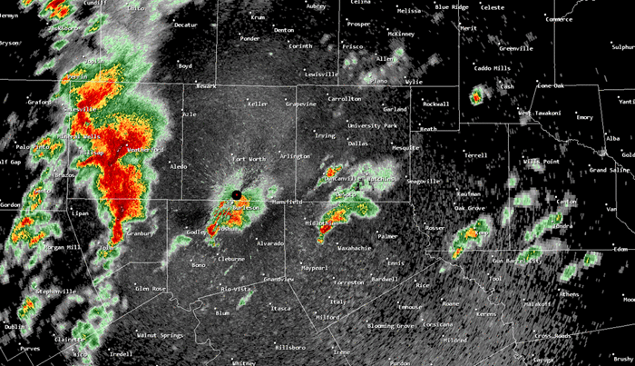
Tornado number 12 was a brief EF0 tornado that occurred in the northern sections of Grand Prairie. The path length was 0.4 miles, and the width was 60 yards.
Tornado number 13 was an EF0 tornado that occurred in the city of Irving. The path length was 1.4 miles, and the width was 40 yards.

Tornado number 14 occurred in Dallas, near Skyline High School. This tornado produced EF0 damage. The path length was 0.1 miles, and the width was 25 yards.

Tornado number 15 occurred in a far southern portion of the city of Denton. This tornado produced minimal EF0 damage. The path length was one quarter mile, and the width was 50 yards.

Tornado number 16 occurred near the community of Poetry in northern Kaufman County. Associated with the same supercell that produced the EF3 tornado in Forney, this EF0 tornado developed shortly after, to the northeast of Forney. The path length was one half mile, and the width was 75 yards.

Tornado number 17 occurred in the Coppell area. This tornado produced EF0 damage in a narrow, non-continuous 2 mile path, and the width was 75 yards.


 Additional information continues to come into the National Weather Service, and the number of confirmed tornadoes may increase.


Radar loop showing supercell thunderstorms moving across the D/FW Metroplex