
A significant heat wave is underway for the Intermountain West, Northern Plains, and Upper Great Lakes, peaking in intensity through midweek and lingering across parts of the Northern Plains and Midwest until this weekend. In southwest Texas, excessive rainfall may bring a risk for potentially life-threatening flash and arroyo flooding through Thursday. Read More >
 |
Now that the 2019-20 snowfall season is underway (many places have already seen a few rounds of light snow), it's time to rewind and examine our last snowfall season (2018-19) within our 30-county coverage area. As outlined in more detail below, the "big story" from last winter is that pretty much our entire area received above-average snowfall.
Below are graphics and tables that reflect seasonal totals, departures from normal/average etc. for the 2018-2019 season. Before continuing though, and in order to give last season's snow totals some perspective, official 30-year normals/averages for our area are:
"Normal"/average seasonal snowfall within our coverage area (based on 1981-2010 data):
** Note: You can access daily and seasonal local snow total maps (updated DAILY) at this page: https://www.weather.gov/gid/Snow
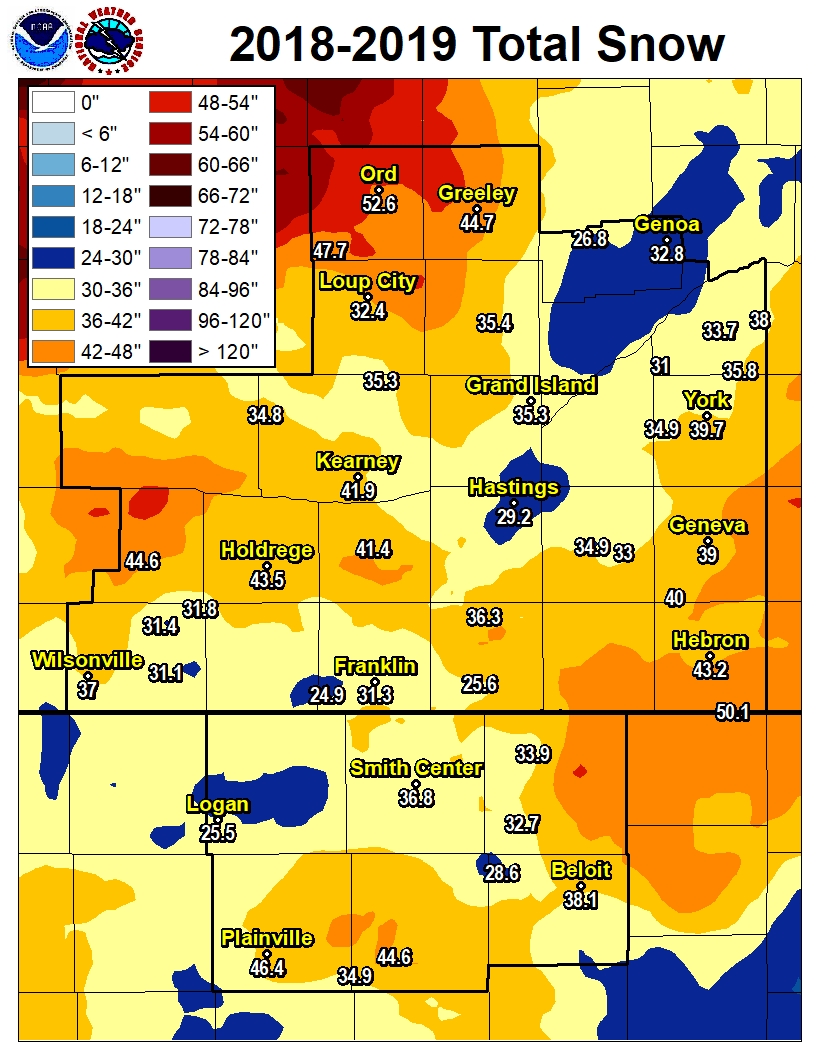
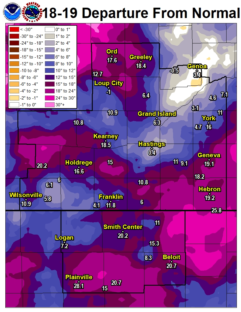
South Central Nebraska/North Central Kansas
2018-19 Seasonal Snow and Departure From Normal
(click image to enlarge)
 |
 |
| 2018-19 Snow Season Totals | 2018-19 Snow Departure From Normal |
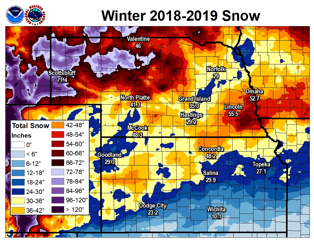
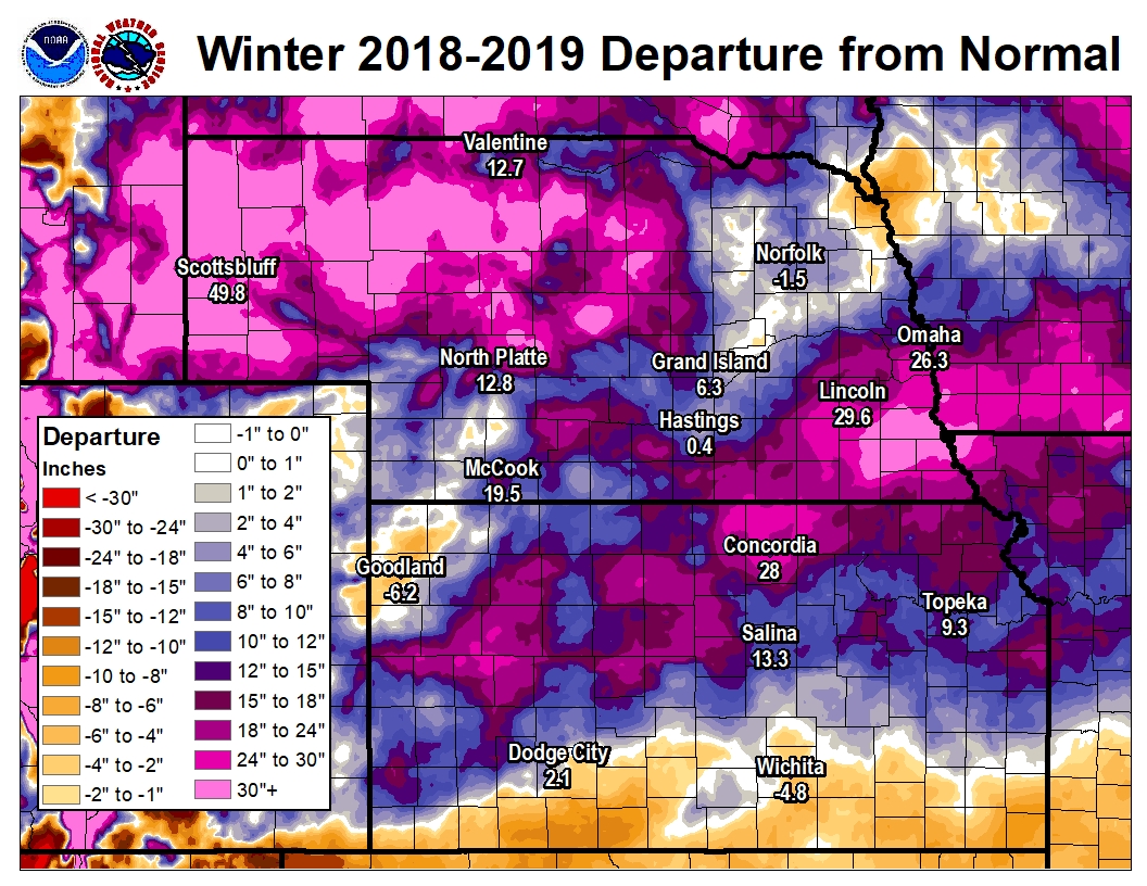
Regional (Central Plains)
2018-19 Seasonal Snow and Departure From Normal
(click image to enlarge)
 |
 |
| 2018-19 Snow Season Totals | 2018-19 Snow Departure From Normal |
WINTER 2018-2019 SOUTH CENTRAL NEBRASKA
COOPERATIVE OBSERVER SNOWFALL
The highest reported amount under each month indicated in BLUE, the lowest amount in RED.
(T* indicates hail and not "true" snow)
| Station | Sep | Oct | Nov | Dec | Jan | Feb | Mar | Apr | May | Season |
| Arcadia | 0.0 | 1.5 | 3.7 | 11.1 | 1.5 | 13.0 | 16.4 | 4.5 | T* | 51.7 |
| Aurora 4N | 0.0 | MSG | MSG | MSG | MSG | MSG | MSG | MSG | MSG | MSG |
| Beaver City | 0.0 | 0.0 | 6.6 | 10.0 | 2.0 | 7.5 | 3.0 | 2.0 | 0.0 | 31.1 |
| Belgrade | 0.0 | T | 1.2 | 5.3 | 1.4 | 9.2 | 7.7 | 2.0 | 0.0 | 26.8 |
| Blue Hill 4SW | 0.0 | 3.7 | 4.5 | 3.9 | 3.1 | 13.8 | 6.4 | 0.9 | 0.0 | 36.3 |
| Bradshaw | 0.0 | 3.0 | 4.5 | 4.0 | 1.5 | 14.5 | 7.4 | T | 0.0 | 34.9 |
| Bruning | 0.0 | MSG | MSG | 2.0 | 11.1 | MSG | MSG | MSG | MSG | MSG |
| Cambridge | 0.0 | 0.9 | 8.3 | 12.0 | 4.0 | 5.1 | 2.2 | 2.1 | 0.0 | 34.6 |
| Lexington 6SSE (Canaday) | 0.0 | 1.0 | 4.5 | 9.2 | 0.2 | 7.5 | 6.0 | 2.0 | 0.0 | 30.4 |
| Clay Center 6ESE | T | 5.0 | 5.8 | 1.7 | 3.8 | 12.5 | 4.2 | T | T* | 33.0 |
| Clay Center | 0.0 | 4.0 | 7.8 | 2.8 | 4.2 | 12.1 | 4.0 | T | 0.0 | 34.9 |
| Edison | 0.0 | T | 4.9 | 10.5 | 2.0 | 10.0 | 2.0 | 2.0 | 0.0 | 31.4 |
| Elwood 8S | 0.0 | 0.5 | 9.5 | 8.9 | 5.0 | 12.3 | 6.2 | 2.2 | 0.0 | 44.6 |
| Franklin | 0.0 | 2.0 | 4.0 | 5.0 | 4.0 | 9.0 | 6.5 | 0.8 | 0.0 | 31.3 |
| Geneva | 0.0 | 7.0 | 6.0 | 1.0 | 7.0 | 15.5 | 2.5 | 0.0 | 0.0 | 39.0 |
| Genoa 2W | 0.0 | 0.5 | 2.0 | 6.8 | 1.5 | 12.5 | 8.5 | 1.0 | 0.0 | 32.8 |
| Grand Island Airport | 0.0 | 1.5 | 7.9 | 4.2 | 1.6 | 10.9 | 8.2 | 1.0 | 0.0 | 35.3 |
| Greeley | 0.0 | 0.2 | 1.5 | 12.9 | 0.8 | 12.7 | 12.5 | 4.1 | T* | 44.7 |
| Gresham 3W | 0.0 | 3.0 | 5.0 | 3.2 | 0.7 | 17.4 | 6.5 | T | T* | 35.8 |
| Harlan County Lake | 0.0 | 3.0 | 4.0 | 5.0 | 5.0 | 7.5 | 3.5 | 0.5 | 0.0 | 28.5 |
| Hastings NWS | 0.0 | 1.1 | 5.5 | 4.3 | 0.9 | 11.6 | 5.3 | 0.5 | T* | 29.2 |
| Hebron | 0.0 | 4.6 | 3.6 | 1.6 | 12.0 | 17.3 | 4.1 | 0.0 | 0.0 | 43.2 |
| Holdrege | 0.0 | 0.5 | 10.5 | 10.5 | 2.0 | 12.5 | 5.5 | 2.0 | 0.0 | 43.5 |
| Hubbell | 0.0 | 4.1 | 12.0 | 1.9 | 11.0 | 17.5 | 3.6 | 0.0 | 0.0 | 50.1 |
| Kearney Airport | 0.0 | 1.4 | 5.7 | 8.7 | 1.5 | 12.9 | 8.6 | 3.1 | T* | 41.9 |
| Loup City | 0.0 | T | 2.3 | 11.9 | 1.2 | 8.2 | 8.0 | 0.8 | T* | 32.4 |
| Miller | 0.0 | 0.2 | 3.1 | 8.9 | 0.3 | 11.0 | 8.1 | 3.2 | T* | 34.8 |
| Minden | 0.0 | T | 10.0 | 7.5 | 1.2 | 12.2 | 8.5 | 2.0 | T* | 41.4 |
| Naponee | 0.0 | 2.5 | 2.4 | 3.0 | 4.6 | 7.7 | 4.7 | 0.4 | T* | 25.3 |
| Ord | 0.0 | 0.3 | 3.8 | 10.5 | 2.4 | 16.0 | 13.6 | 6.0 | 0.0 | 52.6 |
| Osceola | 0.0 | 1.3 | 3.6 | 5.8 | 1.0 | 14.2 | 7.8 | T | T* | 33.7 |
| Oxford 6NNW | T | T | 5.9 | 8.0 | 1.8 | 9.7 | 3.8 | 2.6 | 0.0 | 31.8 |
| Polk | 0.0 | 1.5 | 5.3 | 4.5 | 0.8 | 10.9 | 7.5 | 0.5 | T* | 31.0 |
| Ravenna | 0.0 | 2.0 | 3.5 | 7.6 | 1.7 | 10.3 | 8.6 | 1.6 | T* | 35.3 |
| Red Cloud | 0.0 | 2.5 | 2.1 | 2.5 | 4.5 | 10.5 | 3.5 | T | 0.0 | 25.6 |
| St. Paul | 0.0 | 1.4 | 1.3 | 6.4 | 1.3 | 11.8 | 10.9 | 2.3 | 0.0 | 35.4 |
| Shelby 3NE | 0.0 | 1.2 | 3.8 | 7.7 | 2.0 | 16.0 | 7.3 | T | 0.0 | 38.0 |
| Shickley 4S | 0.0 | 6.8 | 5.0 | 1.5 | 9.0 | 15.0 | 2.7 | T | T* | 40.0 |
| Superior | 0.0 | 0.4 | 4.0 | 1.5 | MSG | MSG | MSG | MSG | MSG | MSG |
| Wilsonville | 0.0 | T | 4.0 | 11.0 | 6.0 | 10.0 | 3.5 | 2.5 | 0.0 | 37.0 |
| York 3N | 0.0 | 3.0 | 5.9 | 3.8 | 1.8 | 17.2 | 8.0 | T | 0.0 | 39.7 |
WINTER 2018-2019 NORTH CENTRAL KANSAS
COOPERATIVE OBSERVER SNOWFALL
The highest reported amount under each month indicated in BLUE, the lowest amount in RED.
(T* indicates hail and not "true" snow)
| Station | Sep | Oct | Nov | Dec | Jan | Feb | Mar | Apr | May | Season |
| Beloit | 0.0 | 0.5 | 9.5 | 3.0 | 9.0 | 13.1 | 3.0 | 0.0 | 0.0 | 38.1 |
| Burr Oak 1N | 0.0 | 1.4 | 4.6 | 1.6 | 8.1 | 11.7 | 6.5 | T | T* | 33.9 |
| Cawker City | 0.0 | 2.0 | 7.5 | 1.0 | 5.6 | 9.5 | 3.0 | 0.0 | 0.0 | 28.6 |
| Covert Rural | 0.0 | 3.0 | 5.0 | 8.5 | 10.0 | 13.0 | 5.1 | 0.0 | 0.0 | 44.6 |
| Glen Elder Dam | 0.0 | T | 5.0 | 2.0 | 5.9 | MSG | MSG | 0.0 | 0.0 | MSG |
| Ionia | 0.0 | 2.5 | 7.4 | 2.2 | 5.7 | 10.4 | 4.5 | T | 0.0 | 32.7 |
| Jewell | 0.0 | 2.0 | 9.0 | 6.0 | 7.0 | MSG | MSG | 2.0 | 0.0 | MSG |
| Kirwin Dam | 0.0 | MSG | 3.5 | 2.3 | 7.3 | 10.8 | 3.0 | 0.5 | 0.0 | MSG |
| Lebanon | 0.0 | 2.0 | 6.2 | 4.0 | 7.4 | 11.8 | 7.1 | T | T* | 38.5 |
| Logan | 0.0 | 1.5 | 3.0 | 4.0 | 6.0 | 6.0 | 4.0 | 1.0 | T* | 25.5 |
| Lovewell Dam | 0.0 | 1.0 | 4.0 | 2.0 | 8.5 | 11.0 | 2.0 | 0.0 | 0.0 | 28.5 |
| Natoma | 0.0 | 3.0 | 7.5 | 3.0 | 7.0 | 10.0 | 4.4 | T | T* | 34.9 |
| Phillipsburg | 0.0 | MSG | MSG | 2.9 | 6.6 | 9.1 | 3.1 | 1.5 | 0.0 | MSG |
| Plainville 4WNW | 0.0 | 3.1 | 12.1 | 2.8 | 10.6 | 12.3 | 5.5 | T | T* | 46.4 |
| Smith Center | 0.0 | 1.2 | 5.8 | 2.4 | 7.0 | 12.4 | 7.0 | 1.0 | 0.0 | 36.8 |
| Webster Dam | 0.0 | 1.1 | 3.7 | MSG | 9.1 | 9.7 | MSG | T | 0.0 | MSG |
The 2018-2019 snowfall season was highlighted/defined by the following points:
Within our 24 South Central Nebraska counties (per NWS observers): the highest 2018-2019 seasonal snow totals were both in Valley County, featuring 52.6" at Ord and 51.7" near Arcadia, while the lowest totals included 25.3" at Naponee (Franklin County) and 25.6" in Red Cloud.
Within our six North Central Kansas counties (per NWS observers): the highest 2018-2019 seasonal totals featured 46.4" near Plainville in Rooks County (an incredible 28.1" above normal!) and 44.6" near Covert (Osborne County), while the lowest amounts included 25.5" at Logan and 28.5" at Lovewell Dam.
In the Nebraska Tri Cities: official seasonal totals included: Kearney 41.9" (18.5" above normal)...Grand Island 35.3" (6.3" above normal)...Hastings 29.2" (0.4" above normal). For Kearney, it was the snowiest winter in 18 years, since 2000-2001 (44.2").
The earliest measurable snow occurred on Oct. 14 (much of the area), and the latest measurable snow occurred on April 30 (mainly only affected northern Valley County...up to 2.5" north of Ord).
These Were a Few of Our "Bigger" Snow Events From The 2018-19 Season (click red links for detailed stories)...
December 26-27, 2018: Winter Storm Brings Heavy Snow to Mainly Northern/Western Areas
January 11-12, 2019: 4-8" of Heavy, Wet Snow Targets Southeast Counties
February 23, 2019: Blizzard Impacts Much of the Southeast Half of the Area
 |
Media use of NWS Web News Stories is encouraged! Please acknowledge the NWS as the source of any news information accessed from this site. |
|

