
Widespread, life-threatening considerable flash flooding is expected in south-central Texas through at least Friday. Catastrophic river flooding and rapid rises on small streams, arroyos, and typically dry washes are expected in the Texas Hill Country. Wildfire smoke is impacting air quality across much of the Great Lakes region into the Northeast U.S. with Air Quality Alerts in effect. Read More >
Brief Summary:
(see tabs below for much more, including full narrative and graphics!)
November 2018 was highlighted by slightly-below average total precipitation (in most areas), but above-average snowfall, particularly within counties along and south of Interstate 80 (including north central KS). Temperature-wise, it was a modestly colder-than-average month, with most locations between 3-5º below normal. (See full narrative below for much more detail!)
NOTE: Information in this story is exclusively for the 30-county NWS Hastings Coverage Area
|
Narrative
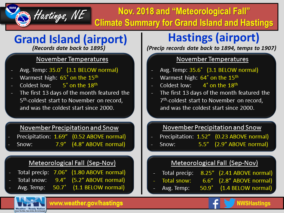
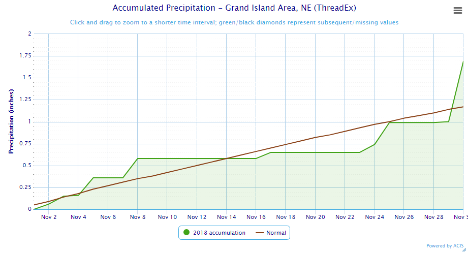
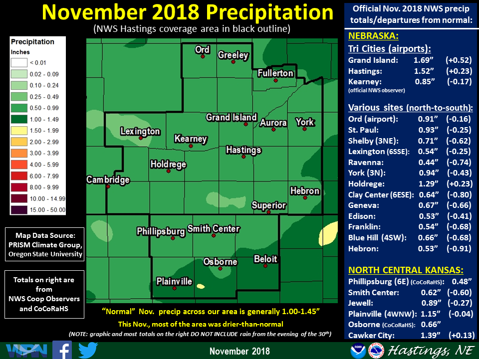
- Precipitation (rainfall+snow liquid): Despite a few decent snow events (see below), November was actually a modestly-dry month overall, with most places receiving less than 1" of liquid equivalent precipitation (normal/average Nov. precipitation is generally between 1.00-1.45"). However, due to a "quirk" of how official precipitation is recorded, automated airport stations that report on a midnight-to-midnight basis (such as Grand Island and Hastings) managed to squeak out slightly above-normal totals, thanks to steady rain that fell on the evening of the 30th (and continued into the morning of Dec. 1st before turning to snow). However, because most official NWS observers report on a 24-hour basis from 7AM-7AM, this Nov. 30th rain was officially reported on Dec. 1st and thus counts as "December rain" for record-keeping purposes. Whether or not the Nov. 30th rain was officially counted with Nov. or Dec. totals, most of the 30-county area featured fairly-uniform precipitation during the month. However, thanks to a fairly significant snow storm/blizzard on the 25th that primarily targeted local north central KS areas, some of the highest monthly totals focused within the following counties: Rooks/Osborne/Mitchell/Jewell. Per dozens of NWS/CoCoRaHS observers, a few of the highest-known November totals featured: 1.78" at Covert KS, 1.69" at Grand Island airport, 1.59" north-northeast of Natoma KS, and 1.57" at Hastings NWS office. On the drier side of things, a few of the lowest Nov. totals included: 0.34" near Cozad, and 0.36" in Miller, Naponee and near Lexington, and 0.44" in Ravenna and near Red Cloud.
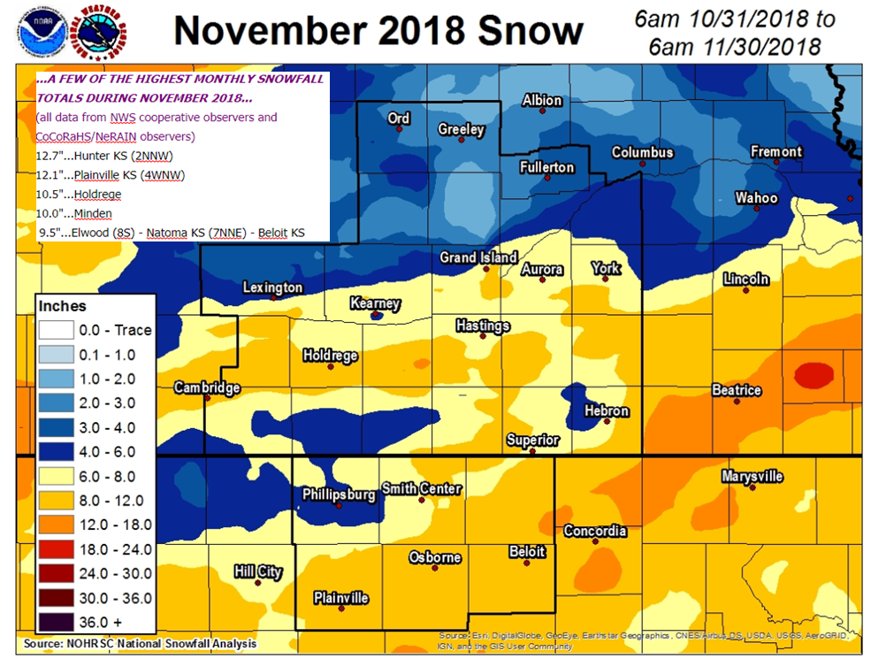
- Snowfall/Winter Weather: For many places, above-normal snowfall was the "big story" of the month, especially for counties along and south of Interstate 80, and particularly within north central KS. Generally speaking, the majority of the area received somewhere between 4-10". Many places (including the Nebraska Tri Cities) received roughly twice-normal November snow, with Grand Island (7.9") notching its snowiest Nov. since 1983. Per NWS/CoCoRaHS observers, a few of the highest November totals featured: 12.7" near Hunter KS, 12.1" near Plainville KS and 12.0" in Hubbell. Most of the snow fell during THREE distinct events:
- 1) Nov. 8th: Two fairly distinct corridors of at least 1-3" fell, one primarily between the Highway 6 and Interstate 80 corridors in Nebraska, and the other within parts of north central KS. Within the northern band, a rather narrow stripe of at least 5-7" targeted mainly southern portions of Gosper, Phelps and Kearney counties, including the Holdrege and Minden areas. Fortunately, winds were fairly light, minimizing impacts.
- 2) Nov. 17: Much of south central Nebraska saw a relatively minor, 1-2" snow on this Saturday, although gusty north winds and accumulation on roads resulted in some travel impacts.
- 3) Nov. 25: This was the overall highest-impact event of the month, as near-blizzard to blizzard conditions slammed primarily portions of north central Kansas, and extending up into mainly the Nuckolls/Thayer County area in Nebraska. Within this zone, snowfall totals of 4-7" were common, whipped by frequent gusts of 40-50+ MPH. Sadly, a 37-year old woman who apparently wandered from her car during the height of blizzard conditions in Mitchell County KS was found dead two days later near Waconda Lake. While the overall-heaviest combo of snow and strong winds impacted the aforementioned southern counties, most of the remainder of the NWS Hastings coverage area (including the Tri Cities) received 1-3".
- Flooding: Despite some unusually-heavy rainfall (by late-fall standards) that began on the evening of Nov. 30th and continued into Dec. 1st, there were NO KNOWN REPORTS OF FLOODING within the NWS Hastings coverage area during November.
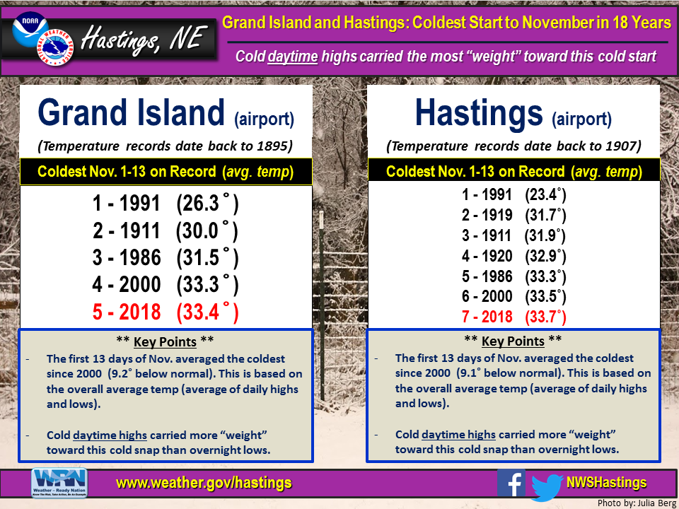
- Temperatures: In some ways November mirrored October, as the month was modestly-colder-than-normal overall, but with the first half colder (versus normal) than the second half. For the month as a whole, most official NWS stations averaged between 3-5º BELOW normal. Specifically at Grand Island and Hastings airports, the first 13 days of the month marked the 5th and 7th-coldest starts to November on record, respectively, mainly due to several chilly daytime highs in the 30s, 40s and even a few 20s. However, a handful of warmer days during the second half of the month helped boost the overall-average, and in the end, the month finished as "only" the 21st-coldest on record at Grand Island and 18th-coldest at Hastings. For the entire area, by far the mildest multi-day stretch focused from the 20th-23rd, with daily highs commonly between the upper-50s and mid-60s. As for monthly extremes per official NWS observers/stations, most of the warmest readings either occurred during the aforementioned mild stretch from the 20th-23rd, or on the 15th, highlighted by: 69º at Cambridge, Beaver City and Webster Dam KS, and 67º at Loup City and Edison. On the opposite end of the thermometer, the mornings of the 9th and 18th were the overall-coldest of the month, highlighted by lows (on one of these two days) of: 1º at York, 3º at Geneva and the Hastings NWS Office, and 4º at several locations, including Kearney, Holdrege and Aurora airports.
- Severe Thunderstorms/Tornadoes/Severe Non-Thunderstorm Winds (for official severe storm reports refer to NCEI Storm Events Database):
- # of confirmed tornadoes during November 2018: Zero (same as 2017)
- Largest known hail stone reported to NWS Hastings: None occurred
- Strongest known measured thunderstorm wind gust: None occured
- Strongest known measured NON-thunderstorm wind gusts: 55 MPH at Hastings airport and 54 MPH at Beloit airport. More details: On the morning of the 25th, intense north winds developed across the entire local area, to the north of a powerful low pressure system centered over southeast KS. In tandem with falling snow, this promoted blizzard to near-blizzard conditions.
- Notable wind damage reported to NWS Hastings (ground-truth reports): None reported
- # of Severe Thunderstorm Warnings issued by NWS Hastings: Zero (same as 2017)
- # of Tornado Warnings issued by NWS Hastings: Zero (same as 2017)
Grand Island & Hastings Details (Including 12-Month History):
 |
| Detailed November 2018 info for Grand Island/Hastings (Click to enlarge) |
 |
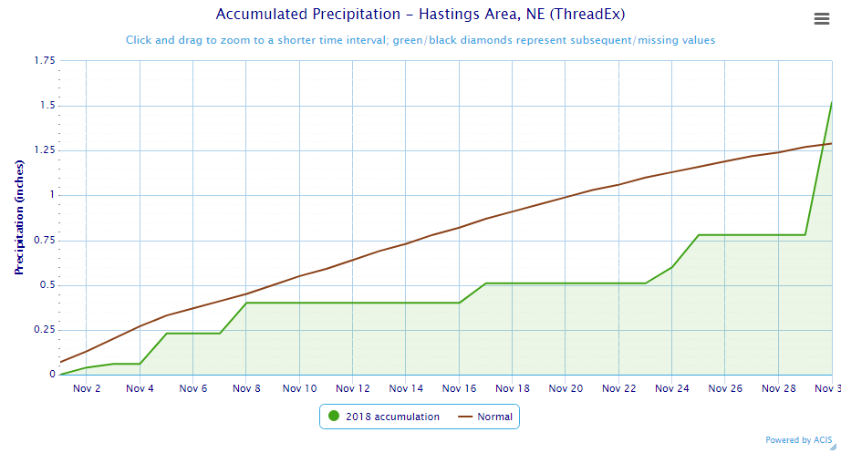 |
| Grand Island Precipitation Summary: The green line indicates cumulative observed precipitation for November 2018.The brown line indicates "normal" November precipitation based on 30-year data from 1981-2010. (click to enlarge) | Hastings Precipitation Summary: The green line indicates cumulative observed precipitation for November 2018. The brown line indicates "normal" November precipitation based on 30-year data from 1981-2010. (click to enlarge) |
| Grand Island (Regional Airport ASOS) - Dec. 2017 - Nov. 2018 | ||||||||||||
| Dec. | Jan. | Feb. | Mar. | Apr. | May | June | July | Aug. | Sept. | Oct. | Nov. | |
| Average High (F) | 37.3 | 34.0 | 33.6 | 51.8 | 55.4 | 78.6 | 88.2 | 85.8 | 84.3 | 77.4 | 61.3 | 45.9 |
| Average Low (F) | 16.0 | 13.5 | 12.5 | 28.8 | 30.8 | 55.5 | 64.8 | 64.6 | 62.5 | 57.4 | 38.1 | 24.2 |
| Average Temperature (F) | 26.6 | 23.7 | 23.1 | 40.3 | 43.1 | 67.0 | 76.5 | 75.2 | 73.4 | 67.4 | 49.7 | 35.0 |
| Departure From Normal | -0.1 | -1.4 | -6.0 | +0.9 | -7.5 | +5.8 | +5.2 | -1.0 | -0.6 | +2.3 | -2.5 | -3.1 |
| Precipitation (in) | 0.45 | 1.08 | 0.75 | 1.26 | 1.26 | 3.98 | 4.61 | 3.58 | 2.67 | 2.49 | 2.88 | 1.69 |
| Departure From Normal | -0.18 | +0.55 | +0.07 | -0.54 | -1.27 | -0.43 | +0.31 | +0.18 | -0.45 | +0.26 | +1.02 | +0.52 |
| Snowfall (in) | 7.2 | 10.2 | 10.6 | 0.4 | 4.1 | 0.0 | 0.0 | 0.0 | 0.0 | 0.0 | 1.5 | 7.9 |
| Departure From Normal | +2.1 | +3.7 | +4.3 | -5.0 | +2.6 | 0.0 | 0.0 | 0.0 | 0.0 | -0.1 | +0.5 | +4.8 |
| Hastings (Municipal Airport ASOS) - Dec. 2017 - Nov. 2018 | ||||||||||||
| Dec. | Jan. | Feb. | Mar. | Apr. | May | June | July | Aug. | Sept. | Oct. | Nov. | |
| Average High (F) | 37.9 | 35.3 | 34.3 | 52.3 | 55.6 | 78.2 | 87.0 | 85.5 | 83.3 | 76.4 | 60.9 | 46.3 |
| Average Low (F) | 15.9 | 14.3 | 12.4 | 27.8 | 30.6 | 55.6 | 65.0 | 65.1 | 63.1 | 58.2 | 38.7 | 24.9 |
| Average Temperature (F) | 26.9 | 24.8 | 23.4 | 40.1 | 43.1 | 66.9 | 76.0 | 75.3 | 73.2 | 67.3 | 49.8 | 35.6 |
| Departure From Normal | -0.7 | -1.2 | -6.5 | +0.2 | -7.6 | +5.6 | +4.2 | -1.8 | -1.1 | +1.7 | -2.8 | -3.1 |
| Precipitation (in) | 0.28 | 0.49 | 0.53 | 1.07 | 1.26 | 3.83 | 5.91 | 2.19 | 4.40 | 3.69 | 3.04 | 1.52 |
| Departure From Normal | -0.33 | +0.08 | +0.04 | -0.72 | -1.30 | -0.74 | +2.11 | -1.55 | +1.10 | +1.13 | +1.05 | +0.23 |
| Snowfall (in) | 5.8 | 5.9 | 8.0 | 0.3 | 6.9 | 0.0 | 0.0 | 0.0 | 0.0 | 0.0 | 1.1 | 5.5 |
| Departure From Normal | -0.3 | -0.1 | +1.5 | -4.9 | +5.7 | 0.0 | 0.0 | 0.0 | 0.0 | -0.2 | +0.1 | +2.9 |
Kearney - 12 Month Climate History:
All data here is from the official NWS observer at Kearney airport, with 24-hour observations taken around 7 a.m. ** PLEASE NOTE: This official Kearney data often differs slightly from the unofficial data recorded by the automated airport system (KEAR) **
| Kearney Airport (Coop Observer) - Dec. 2017 - Nov. 2018 | ||||||||||||
| Dec. | Jan. | Feb. | Mar. | Apr. | May | June | July | Aug. | Sept. | Oct. | Nov. | |
| Average High (F) | 38.7 | 32.2 | 32.9 | 51.9 | 53.8 | 75.9 | 86.6 | 84.6 | 82.3 | 77.6 | 59.0 | 45.2 |
| Average Low (F) | 15.5 | 11.1 | 10.6 | 26.1 | 28.6 | 52.7 | 62.9 | 63.0 | 59.9 | 55.8 | 35.7 | 22.6 |
| Average Temperature (F) | 27.1 | 21.6 | 21.7 | 39.0 | 41.2 | 64.3 | 74.7 | 73.8 | 71.1 | 66.7 | 47.3 | 33.9 |
| Departure From Normal | +1.2 | -3.0 | -6.4 | +1.3 | -7.5 | +4.8 | +4.9 | -0.9 | -1.5 | +3.2 | -3.6 | -3.1 |
| Precipitation (in) | 0.21 | 0.96 | 0.73 | 1.05 | 2.03 | 5.56 | 2.87 | 6.07 | 2.05 | 1.85 | 3.50 | 0.85 |
| Departure From Normal (in) | -0.36 | +0.47 | +0.18 | -0.74 | -0.20 | +1.38 | -1.06 | +2.79 | -1.03 | -0.22 | +1.46 | -0.17 |
| Snowfall (in) | 4.3 | 6.8 | 9.2 | 0.7 | 9.7 | 0.0 | 0.0 | 0.0 | 0.0 | 0.0 | 1.4 | 5.7 |
| Departure From Normal (in) | +0.8 | +2.4 | +4.1 | -3.9 | +7.9 | 0.0 | 0.0 | 0.0 | 0.0 | -0.2 | +0.7 | +2.6 |
Ord - 12 Month Climate History:
All snowfall data is from the NWS Cooperative Observer in town. In addition, winter precipitation totals often include Cooperative Observer data given that the automated airport equipment is not designed to accurately melt snowfall liquid equivalent (in most cases).
| Ord (Evelyn Sharp Field ASOS) - Dec. 2017 - Nov. 2018 | ||||||||||||
| Dec. | Jan. | Feb. | Mar. | Apr. | May | June | July | Aug. | Sept. | Oct. | Nov. | |
| Average High (F) | 36.6 | 34.3 | 31.2 | 49.9 | 54.1 | 75.4 | 84.0 | 84.0 | 82.2 | 75.4 | 59.5 | 45.3 |
| Average Low (F) | 14.1 | 10.2 | 9.0 | 25.5 | 27.3 | 51.8 | 60.8 | 62.0 | 59.1 | 54.5 | 33.6 | 20.2 |
| Average Temperature (F) | 25.3 | 22.2 | 20.1 | 37.7 | 40.7 | 63.6 | 72.4 | 73.0 | 70.6 | 65.0 | 46.5 | 32.8 |
| Departure From Normal | +0.4 | -2.4 | -7.7 | 0.0 | -8.1 | +4.3 | +3.2 | -1.4 | -2.4 | +1.4 | -3.1 | -3.5 |
| Precipitation (in) | 0.43 | 0.83 | 0.53 | 0.62 | 1.47 | 4.38 | 7.57 | 5.84 | 2.57 | 1.53 | 2.47 | 0.91 |
| Departure From Normal (in) | -0.16 | +0.46 | +0.09 | -0.83 | -1.12 | +0.57 | +3.45 | +2.87 | -0.59 | -0.91 | +0.54 | -0.16 |
| Snowfall (in) | 5.3 | 12.4 | 8.6 | 1.1 | 10.1 | 0.0 | 0.0 | 0.0 | 0.0 | 0.0 | 0.3 | 3.8 |
| Departure From Normal (in) | -2.1 | +5.6 | +2.6 | -4.8 | +7.6 | 0.0 | 0.0 | 0.0 | 0.0 | 0.0 | -0.8 | -1.5 |
Smith Center, KS - 12 Month Climate History:
All data is from the official NWS observer, with 24-hour observations taken around 7 a.m. As a result, data may vary slightly from true "Calendar Day".
| Smith Center KS (NWS Coop Observer) - Dec. 2017 - Nov. 2018 | ||||||||||||
| Dec. | Jan. | Feb. | Mar. | Apr. | May | June | July | Aug. | Sept. | Oct. | Nov. | |
| Average High (F) | 43.6 | 39.1 | 39.4 | 57.8 | 58.4 | 82.7 | 92.2 | 90.7 | 86.9 | 80.9 | 62.5 | 48.6 |
| Average Low (F) | 17.6 | 12.6 | 13.5 | 27.9 | 29.6 | 55.6 | 63.9 | 65.5 | 62.5 | 57.6 | 38.5 | 24.4 |
| Average Temperature (F) | 30.6 | 25.9 | 26.4 | 42.8 | 44.0 | 69.1 | 78.0 | 78.1 | 74.7 | 69.3 | 50.5 | 36.5 |
| Departure From Normal | +1.8 | -1.8 | -5.6 | +1.2 | -8.5 | +5.4 | +4.0 | -1.6 | -2.5 | +1.1 | -4.3 | -3.9 |
| Precipitation (in) | 0.11 | 0.32 | 0.31 | 1.05 | 0.91 | 2.62 | 6.33 | 3.98 | 3.25 | 3.88 | 4.61 | 0.62 |
| Departure From Normal (in) | -0.55 | -0.17 | -0.27 | -0.82 | -1.36 | -1.30 | +2.72 | +0.11 | -0.05 | +1.84 | +2.73 | -0.60 |
| Snowfall (in) | 2.0 | 3.5 | 7.6 | T | 2.0 | 0.0 | 0.0 | 0.0 | 0.0 | 0.0 | 1.2 | 5.8 |
| Departure From Normal (in) | -1.2 | -0.2 | +3.5 | -2.6 | +1.4 | 0.0 | 0.0 | 0.0 | 0.0 | -0.2 | +0.8 | +4.0 |
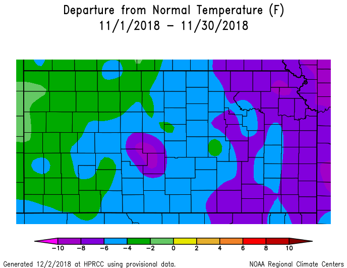
Temperature & Precipitation Departure From Normal Maps:
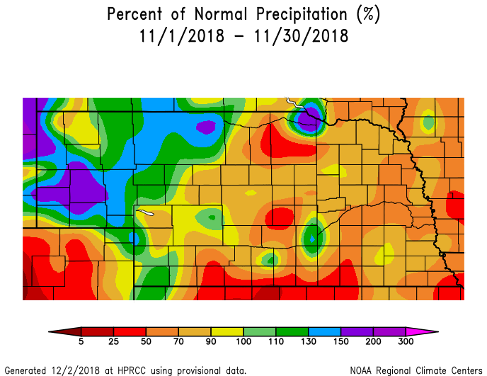
These images depict November 2018 monthly temperature departure from normal & precipitation percent-of-normal for both Nebraska & Kansas. Images are courtesy of the High Plains Regional Climate Center (HPRCC). Please note: These maps occasionally contain "bullseyes" of errant data. For precipitation, you can also generate departure from normal/percent-of-normal maps using the NWS AHPS page, or view local-area images generated each day by NWS Hastings.
 |
 |
 |
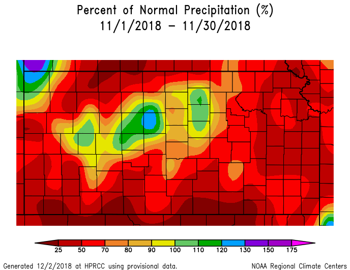 |
| Departure from Normal Temperature - NE (left) & KS (right) | Percent of Normal Precipitation - NE (left) & KS (right) | ||
Drought:
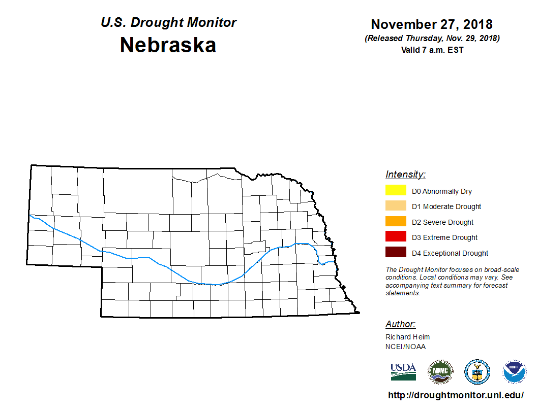
The following drought images, current as of November 27, 2018, are courtesy of the U.S. Drought Monitor
Summary of changes during November 2018 across the NWS Hastings coverage area:
Despite most of the area observing at least slightly below-normal precipitation during November, the lingering effects of above-normal precipitation in recent months, along with cooler-than-normal temperatures, kept the ENTIRE NWS Hastings coverage area void of all drought categories during the month.
 |
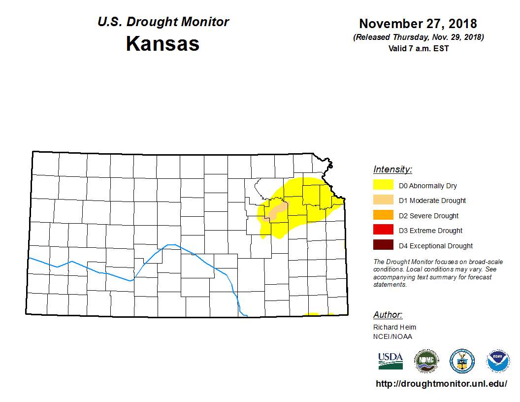 |
| Drought Monitor for Nebraska (left) & Kansas (right). Valid as of November 27, 2018 (click to enlarge) | |
November 2018 Extremes for the NWS Hastings Coverage Area:
...A FEW OF THE WARMEST HIGH TEMPERATURES DURING NOVEMBER 2018...
(all data from NWS cooperative observers or automated airport sites, with the date it actually occurred indicated in parentheses)
69 degrees...Cambridge (22nd) - Webster Dam KS (22nd) - Beaver City (22nd)
67 degrees...Loup City (21st) - Edison (22nd)
66 degrees...Lexington airport (22nd) - Smith Center KS (22nd) - Ravenna (22nd) - Ord airport (22nd) - Genoa 2W (15th) - Kirwin Dam KS (15th)
65 degrees...Grand Island airport (15th) - York 3N (15th) - Plainville KS 4WNW (23rd) - Oxford 6NNW (22nd) - Red Cloud (21st) - Franklin (22nd) - Beloit KS (23rd) - Gothenburg (21st) - Harlan County Lake (21st)
...A FEW OF THE COLDEST LOW TEMPERATURES DURING NOVEMBER 2018...
(all data from NWS cooperative observers or automated airport sites, with the date it actually occurred indicated in parentheses)
1 degree...York airport (18th)
3 degrees...Hastings NWS Office (18th) - Geneva (18th)
4 degrees...Gothenburg (18th) - Holdrege airport (9th) - Kearney airport (9th) - Ravenna (18th) - Greeley (13th) - Red Cloud (18th) - Aurora airport (18th) - Oxford 6NNW (18th) - Osceola (18th)
...A FEW OF THE HIGHEST MONTHLY PRECIPITATION TOTALS DURING NOVEMBER 2018...
(all data from NWS cooperative observers and CoCoRaHS/NeRAIN observers unless indicated)
1.78"...Covert KS
1.69"...Grand Island airport (includes 0.69" of rain on the 30th)
1.59"...Natoma KS (7NNE)
1.57"...Hastings NWS Office (includes 0.77" of rain on the 30th)
1.52"...Hastings airport (includes 0.74" of rain on the 30th)
1.39"...Cawker City
1.30"...Hunter KS (2NNW)
1.29"...Holdrege
1.15"...Plainville KS (4WNW)
1.12"...Beloit KS - Superior (8NW)
...A FEW OF THE LOWEST MONTHLY PRECIPITATION TOTALS DURING NOVEMBER 2018...
(all data from NWS cooperative observers and CoCoRaHS/NeRAIN observers unless indicated)
(NOTE: None of these totals include rain that fell on Nov. 30th, as this will be included with Dec. 1st observations)
0.34"...Cozad (4S)
0.36"...Naponee - Miller - Lexington (1E)
0.44"...Ravenna - Red Cloud (4E)
0.46"...Oxford 6NNW
0.48"...Phillipsburg (6E)
0.49"...Harlan County Lake - Beaver City
...A FEW OF THE HIGHEST MONTHLY SNOWFALL TOTALS DURING NOVEMBER 2018...
(all data from NWS cooperative observers and CoCoRaHS/NeRAIN observers)
12.7"...Hunter KS (2NNW)
12.1"...Plainville KS (4WNW)
12.0"...Hubbell
10.5"...Holdrege
10.0"...Minden
9.5"...Elwood (8S) - Natoma KS (7NNE) - Beloit KS
9.0"...Jewell KS
8.3"...Cambridge
7.9"...Grand Island (airport)
 |
Media use of NWS Web News Stories is encouraged! Please acknowledge the NWS as the source of any news information accessed from this site. |
|

