Central Illinois
Weather Forecast Office
Tornado #7
Greene/Scott/Morgan Counties
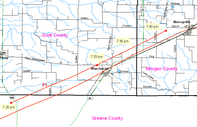
While investigating the track of the 66-mile-long tornado path, survey teams from the Lincoln and St. Louis NWS offices were able to uncover a separate tornado track, just north of the main track.
This tornado developed in north central Greene County, along county road 2700N, 1/2 mile west of highway 106 (or about 1.5 miles west-northwest of Barow). It developed around 7:20 pm and moved northeast into southern Scott County. The tornado crossed the Alsey-Manchester Road, about 3/4 mile northwest of Manchester, around 7:33 pm., and continued northeast, crossing the Scott/Morgan County line 2.75 miles west-southwest of Murrayville around 7:35 pm. It finally lifted about 1.25 miles west of Murrayville at 7:40 pm.
The intensity of this tornado was determined to be F1, with a width of 75 yards and a path of 9.75 miles.
Event Links: Overview | Long-Track Tornado | Springfield | Franklin/Loami | Eastern Sangamon
Southern Logan | Greene/Scott #2 | Logan/Macon | Macon/De Witt | Radar&Satellite
US Dept of Commerce
National Oceanic and Atmospheric Administration
National Weather Service
Central Illinois
1362 State Route 10
Lincoln, IL 62656
217-732-7321 (forecast recording) or 217-732-3089
Comments? Questions? Please Contact Us.

