Overview
|
Information on this may still be updated if new data is found. Numerous strong to severe thunderstorms developed in the late afternoon of May 16 and moved across central Indiana into the evening. Tornadoes, hail up to around 4 inches in diameter, and widespread wind damage occurred. Winds gusted over 80 mph in some areas. |
Tornadoes
Select a tornado from the table to zoom into the track and view more information. The default table view is limited to 8 tracks, but can be scrolled by a mouse wheel or dynamically expanded. Additionally, the table can fill the entire window by clicking the small circular expanding arrow icon at the very top right of the table and returned to its original size by clicking the button again. The side information panel that opens over the map can be closed using the "X" on the upper right corner of the pop-up. Zoom into the map and click damage points to see detailed information and pictures from the surveys.
|
NOTE: times shown below are local to your device's time zone. |

The Enhanced Fujita (EF) Scale classifies tornadoes into the following categories:
| EF0 Weak 65-85 mph |
EF1 Moderate 86-110 mph |
EF2 Significant 111-135 mph |
EF3 Severe 136-165 mph |
EF4 Extreme 166-200 mph |
EF5 Catastrophic 200+ mph |
 |
|||||
| Tornadoes that fail to impact any ratable structures on the EF-Scale are rated EF-Unknown (EF-U) | |||||
Storm Reports
Preliminary Local Storm Report...Summary
National Weather Service Indianapolis IN
932 AM EDT Sat May 17 2025
..TIME... ...EVENT... ...CITY LOCATION... ...LAT.LON...
..DATE... ....MAG.... ..COUNTY LOCATION..ST.. ...SOURCE....
..REMARKS..
0602 PM Tstm Wnd Gst 1 SW Turkey Run State P 39.88N 87.23W
05/16/2025 M42 MPH Parke IN Trained Spotter
0617 PM Tstm Wnd Dmg 4 NW West Lafayette 40.49N 86.96W
05/16/2025 Tippecanoe IN Public
Powerlines down on Taft Road.
0628 PM Hail Sullivan 39.10N 87.41W
05/16/2025 E1.00 Inch Sullivan IN Emergency Mngr
0631 PM Hail 1 S Sullivan 39.08N 87.41W
05/16/2025 E1.75 Inch Sullivan IN Emergency Mngr
0634 PM Hail Sullivan 39.10N 87.41W
05/16/2025 E1.75 Inch Sullivan IN Public
0634 PM Hail 2 ENE Sullivan 39.11N 87.38W
05/16/2025 E4.00 Inch Sullivan IN Amateur Radio
0635 PM Tstm Wnd Dmg 3 SE Crawfordsville 40.02N 86.85W
05/16/2025 Montgomery IN Public
TREES DOWN.
0635 PM Hail Sullivan 39.10N 87.41W
05/16/2025 E2.75 Inch Sullivan IN Emergency Mngr
GOLFBALL TO BASEBALL SIZED.
0637 PM Tstm Wnd Gst 2 SW Purdue University 40.41N 86.94W
05/16/2025 M49 MPH Tippecanoe IN Official NWS Obs
KLAF METAR OBSERVATION.
0640 PM Tstm Wnd Dmg Attica 40.29N 87.25W
05/16/2025 Fountain IN Law Enforcement
MULTIPLE REPORTS OF TREES DOWN IN THE AREA.
0643 PM Tstm Wnd Gst 3 E Camden 40.62N 86.48W
05/16/2025 M53 MPH Carroll IN Public
0644 PM Tornado 2 SE Dugger 39.05N 87.23W
05/16/2025 Greene IN NWS Storm Survey
*** 1 FATAL, 3 INJ ***
An EF-2 tornado with peak wind speeds of 128
mph and a path width of 200 yards tracked
for 14.04 miles for 22 minutes beginning at
this location.
0645 PM Hail 1 W Plainfield 39.71N 86.41W
05/16/2025 M0.50 Inch Hendricks IN Public
Report from mPING: Half-inch (0.50 in.).
0649 PM Hail 1 NE Plainfield 39.71N 86.38W
05/16/2025 M0.50 Inch Hendricks IN Public
Report from mPING: Half-inch (0.50 in.).
0651 PM Hail 2 W Indianapolis Int`l 39.73N 86.33W
05/16/2025 M0.50 Inch Hendricks IN Public
Report from mPING: Half-inch (0.50 in.).
0652 PM Tstm Wnd Gst Indianapolis Int`l Airp 39.72N 86.30W
05/16/2025 M75 MPH Marion IN Official NWS Obs
Corrects previous tstm wnd gst report from
Indianapolis Int`l Airport. KIND METAR
OBSERVATION.
0655 PM Tornado 2 NW Switz City 39.05N 87.07W
05/16/2025 Greene IN Public
0655 PM Tornado 4 NE Linton 39.07N 87.15W
05/16/2025 Greene IN Trained Spotter
REPORTED LARGE STRONG TORNADO.
0656 PM Tstm Wnd Dmg 1 NE Zionsville 39.96N 86.27W
05/16/2025 Boone IN Public
Trees down.
0705 PM Hail 2 SW Greenwood 39.60N 86.14W
05/16/2025 E0.50 Inch Johnson IN Public
Report from mPING: Half-inch (0.50 in.).
0706 PM Tornado 3 S Worthington 39.08N 86.96W
05/16/2025 Greene IN Trained Spotter
0707 PM Hail 1 S Greenwood 39.59N 86.11W
05/16/2025 E0.50 Inch Johnson IN Public
Report from mPING: Half-inch (0.50 in.).
0707 PM Hail 2 SW Greenwood 39.60N 86.14W
05/16/2025 M0.50 Inch Johnson IN Public
Report from mPING: Half-inch (0.50 in.).
0707 PM Tstm Wnd Gst 2 SE Beech Grove 39.70N 86.06W
05/16/2025 M65 MPH Marion IN Trained Spotter
65-70 MPH WINDS.
0708 PM Tstm Wnd Dmg 3 N Fishers 40.00N 86.01W
05/16/2025 Hamilton IN Public
0708 PM Hail 2 NW New Whiteland 39.58N 86.12W
05/16/2025 E1.00 Inch Johnson IN Public
Report from mPING: Quarter (1.00 in.).
0710 PM Tstm Wnd Dmg 2 WSW Fishers 39.95N 86.05W
05/16/2025 Hamilton IN Emergency Mngr
REPORTS OF MULTIPLE TREES DOWN., ALSO
REPORTS OF 0.75 INCH HAIL.
0712 PM Hail 1 SE Bargersville 39.51N 86.14W
05/16/2025 E0.25 Inch Johnson IN Public
0712 PM Hail 5 ESE Freedom 39.19N 86.77W
05/16/2025 M2.75 Inch Owen IN Cocorahs
Shredded leaves, vehicle dents, broken
windows to house and vehicles.
0715 PM Tstm Wnd Dmg 2 W Morse Reservoir 40.10N 86.07W
05/16/2025 Hamilton IN Public
LARGE TREES DOWN.
0715 PM Tstm Wnd Dmg 1 W New Whiteland 39.56N 86.11W
05/16/2025 Johnson IN Public
0715 PM Hail 1 W New Whiteland 39.56N 86.11W
05/16/2025 M0.25 Inch Johnson IN Public
0715 PM Hail 4 E Waverly 39.57N 86.20W
05/16/2025 E0.75 Inch Johnson IN Public
Report from mPING: Dime (0.75 in.).
0715 PM Hail 5 E Freedom 39.19N 86.78W
05/16/2025 E1.00 Inch Owen IN Public
Report from mPING: Quarter (1.00 in.).
0715 PM Tornado 5 W Solsberry 39.08N 86.86W
05/16/2025 Greene IN NWS Storm Survey
Late report. EF-1 tornado with peak winds of
94 mph and a path length of 1.82 miles
impacted a rural area east of Tulip where it
tracked eastward causing widespread tree
damage.
0716 PM Tstm Wnd Gst 5 SSE Mccordsville 39.84N 85.90W
05/16/2025 M63 MPH Hancock IN Official NWS Obs
KMQJ - MOUNT COMFORT AIRPORT METAR OBS.
0716 PM Hail 2 SE Whiteland 39.52N 86.07W
05/16/2025 M0.50 Inch Johnson IN Public
Report from mPING: Half-inch (0.50 in.).
0721 PM Tstm Wnd Gst Frankton 40.22N 85.77W
05/16/2025 M71 MPH Madison IN Public
0722 PM Hail 3 E Whiteland 39.55N 86.03W
05/16/2025 E0.50 Inch Johnson IN Public
Report from mPING: Half-inch (0.50 in.).
0723 PM Tstm Wnd Gst 2 SW Frankton 40.20N 85.81W
05/16/2025 M83 MPH Madison IN Emergency Mngr
0725 PM Hail Whitehall 39.17N 86.57W
05/16/2025 E0.50 Inch Monroe IN Public
Report from mPING: Half-inch (0.50 in.).
0726 PM Hail 2 NW Whitehall 39.19N 86.59W
05/16/2025 E1.75 Inch Monroe IN Public
Report from mPING: Golf Ball (1.75 in.).
0727 PM Tornado 9 SSW Ellettsville 39.11N 86.68W
05/16/2025 Monroe IN NWS Storm Survey
An EF-2 tornado with peak wind speeds of 128
mph and a path width of 350 yards tracked
for 35.27 miles over 44 minutes beginning at
this location.
0727 PM Hail Mccormicks Creek State 39.29N 86.76W
05/16/2025 E0.88 Inch Owen IN Public
0728 PM Hail 1 S Ellettsville 39.21N 86.62W
05/16/2025 M1.75 Inch Monroe IN Public
0730 PM Tstm Wnd Dmg Solsberry 39.09N 86.76W
05/16/2025 Greene IN Amateur Radio
SEVERAL TREES DOWN.
0730 PM Tstm Wnd Dmg 3 NE Orestes 40.31N 85.69W
05/16/2025 Madison IN Emergency Mngr
MULTIPLE REPORTS OF TREES AND POWERLINES
DOWN NORTHERN MADISON COUNTY.
0730 PM Tstm Wnd Dmg 4 S Whitehall 39.12N 86.58W
05/16/2025 Monroe IN Public
100 Trees down.
0730 PM Tornado 6 SW Whitehall 39.11N 86.64W
05/16/2025 Monroe IN Public
0730 PM Hail 2 SE Ellettsville 39.22N 86.60W
05/16/2025 E1.75 Inch Monroe IN Public
Report from mPING: Golf Ball (1.75 in.).
0730 PM Tornado 3 SW BLOOMINGTON 39.16N 86.56W
05/16/2025 Monroe IN Trained Spotter
REPORTED DEBRIS.
0732 PM Tstm Wnd Gst 2 W Homecroft 39.68N 86.17W
05/16/2025 M80 MPH Marion IN Public
0732 PM Hail 2 S Shepardsville 39.57N 87.42W
05/16/2025 E0.50 Inch Vigo IN Public
Report from mPING: Half-inch (0.50 in.).
0733 PM Hail Ellettsville 39.23N 86.63W
05/16/2025 M1.00 Inch Monroe IN Emergency Mngr
0735 PM Hail Ellettsville 39.23N 86.62W
05/16/2025 E1.00 Inch Monroe IN Public
Report from mPING: Quarter (1.00 in.).
0735 PM Hail 1 NW Whitehall 39.18N 86.58W
05/16/2025 M1.50 Inch Monroe IN Public
0737 PM Hail 1 NE North Terre Haute 39.55N 87.35W
05/16/2025 E0.50 Inch Vigo IN Public
Report from mPING: Half-inch (0.50 in.).
0738 PM Tornado 1 SE Bloomington 39.15N 86.51W
05/16/2025 Monroe IN Public
0741 PM Hail 2 N North Terre Haute 39.56N 87.36W
05/16/2025 E0.50 Inch Vigo IN Public
Report from mPING: Half-inch (0.50 in.).
0742 PM Hail 1 WNW Nashville 39.21N 86.25W
05/16/2025 M1.00 Inch Brown IN Emergency Mngr
0745 PM Tstm Wnd Dmg 3 NE Greenfield 39.81N 85.73W
05/16/2025 Hancock IN Law Enforcement
LARGE DIAMETER TREE LIMBS DOWN. TIME
ESTIMATED BY RADAR.
0747 PM Hail 1 SW North Vernon 39.00N 85.64W
05/16/2025 E0.75 Inch Jennings IN Public
Report from mPING: Dime (0.75 in.).
0749 PM Hail Manilla 39.57N 85.61W
05/16/2025 E0.88 Inch Rush IN Fire Dept/Rescue
0750 PM Tstm Wnd Dmg 3 ESE Muncie 40.17N 85.34W
05/16/2025 Delaware IN Public
Trees down.
0753 PM Tornado 5 NW Graysville 39.17N 87.62W
05/16/2025 Sullivan IN NWS Storm Survey
An EF-0 tornado with peak wind speeds of
80mph and a path width of 50 yards tracked
for 0.85 miles over 2 minutes beginning at
this location.
0757 PM Tstm Wnd Dmg Selma 40.19N 85.27W
05/16/2025 Delaware IN Public
LARGE BRANCH DOWN.
0758 PM Tornado 2 E Lena 39.61N 87.00W
05/16/2025 Putnam IN NWS Storm Survey
An EF-0 tornado with peak wind speeds of 85
mph and a path width of 20 yards tracked for
0.43 miles over 2 minutes beginning at this
location.
0800 PM Hail 2 N Indiana State Unive 39.50N 87.41W
05/16/2025 E0.70 Inch Vigo IN Amateur Radio
0805 PM Tstm Wnd Dmg Parker City 40.19N 85.21W
05/16/2025 Randolph IN Amateur Radio
DAMAGE TO SIGNS AND FENCES BLOWN DOWN AT
BASEBALL FIELDS.
0807 PM Hail Rushville 39.61N 85.45W
05/16/2025 M0.70 Inch Rush IN Emergency Mngr
0812 PM Hail 2 W Brownsburg 39.84N 86.43W
05/16/2025 M1.00 Inch Hendricks IN Public
Report from mPING: Quarter (1.00 in.).
0813 PM Hail 2 NW Brownsburg 39.86N 86.42W
05/16/2025 E0.75 Inch Hendricks IN Public
Report from mPING: Dime (0.75 in.).
0816 PM Hail 1 SE Columbus 39.20N 85.90W
05/16/2025 M1.25 Inch Bartholomew IN Trained Spotter
0816 PM Hail 1 N New Salem 39.55N 85.36W
05/16/2025 M1.00 Inch Rush IN Law Enforcement
0817 PM Hail 1 NW Brownsburg 39.86N 86.40W
05/16/2025 E0.75 Inch Hendricks IN Public
Report from mPING: Dime (0.75 in.).
0820 PM Funnel Cloud 1 SSW Columbus 39.19N 85.92W
05/16/2025 Bartholomew IN Trained Spotter
0823 PM Tstm Wnd Dmg 1 NE Zionsville 39.97N 86.26W
05/16/2025 Boone IN Amateur Radio
Tree damage.
0827 PM Hail 4 SE Zionsville 39.91N 86.23W
05/16/2025 E0.50 Inch Marion IN Public
Report from mPING: Half-inch (0.50 in.).
0828 PM Hail 3 NE Eagle Creek Reserv 39.89N 86.27W
05/16/2025 E0.50 Inch Marion IN Public
Report from mPING: Half-inch (0.50 in.).
0832 PM Hail 3 W Meridian Hills 39.91N 86.21W
05/16/2025 E0.50 Inch Marion IN Public
Report from mPING: Half-inch (0.50 in.).
0835 PM Hail 1 SE Carmel 39.96N 86.09W
05/16/2025 M0.50 Inch Hamilton IN Public
0839 PM Hail 2 NE Carmel 39.99N 86.08W
05/16/2025 M0.75 Inch Hamilton IN Public
Report from mPING: Dime (0.75 in.).
0839 PM Rain 3 NE Carmel 40.01N 86.07W
05/16/2025 M1.00 Inch Hamilton IN Public
0842 PM Hail 2 N Fishers 39.99N 86.01W
05/16/2025 M0.75 Inch Hamilton IN NWS Employee
0843 PM Hail 3 NE Fishers 39.99N 86.00W
05/16/2025 E0.50 Inch Hamilton IN Public
Report from mPING: Half-inch (0.50 in.).
0845 PM Hail 2 N Fishers 39.99N 86.01W
05/16/2025 E0.75 Inch Hamilton IN Public
Report from mPING: Dime (0.75 in.).
0850 PM Tornado 2 SSW Stinesville 39.28N 86.67W
05/16/2025 Monroe IN Trained Spotter
0858 PM Hail 3 NW Homecroft 39.70N 86.16W
05/16/2025 M0.50 Inch Marion IN Public
Report from mPING: Half-inch (0.50 in.).
0858 PM Funnel Cloud 4 E Ellettsville 39.23N 86.54W
05/16/2025 Monroe IN Public
0900 PM Funnel Cloud 7 E Stinesville 39.30N 86.52W
05/16/2025 Monroe IN Trained Spotter
0904 PM Hail 1 NNW Anderson 40.10N 85.69W
05/16/2025 M0.70 Inch Madison IN Public
0921 PM Hail 4 E Southport 39.65N 86.04W
05/16/2025 M0.50 Inch Marion IN Public
Report from mPING: Half-inch (0.50 in.).
0922 PM Hail 4 E Southport 39.65N 86.04W
05/16/2025 E0.70 Inch Marion IN Public
0924 PM Hail Morristown 39.67N 85.70W
05/16/2025 E0.50 Inch Shelby IN Public
Report from mPING: Half-inch (0.50 in.).
0925 PM Hail Morristown 39.67N 85.70W
05/16/2025 E0.70 Inch Shelby IN Law Enforcement
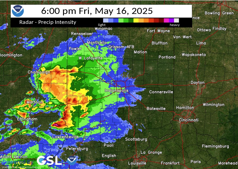
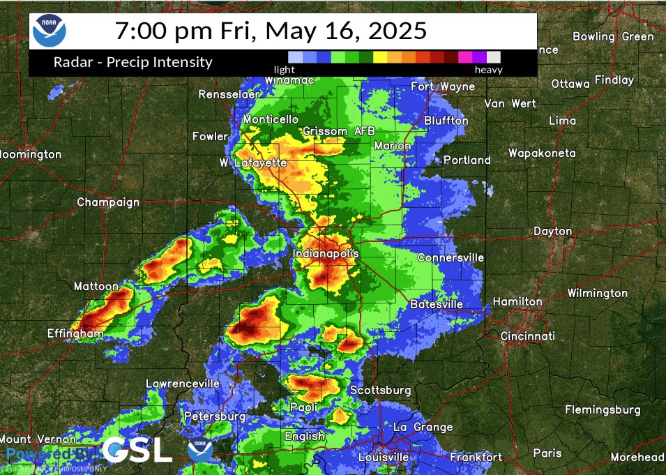
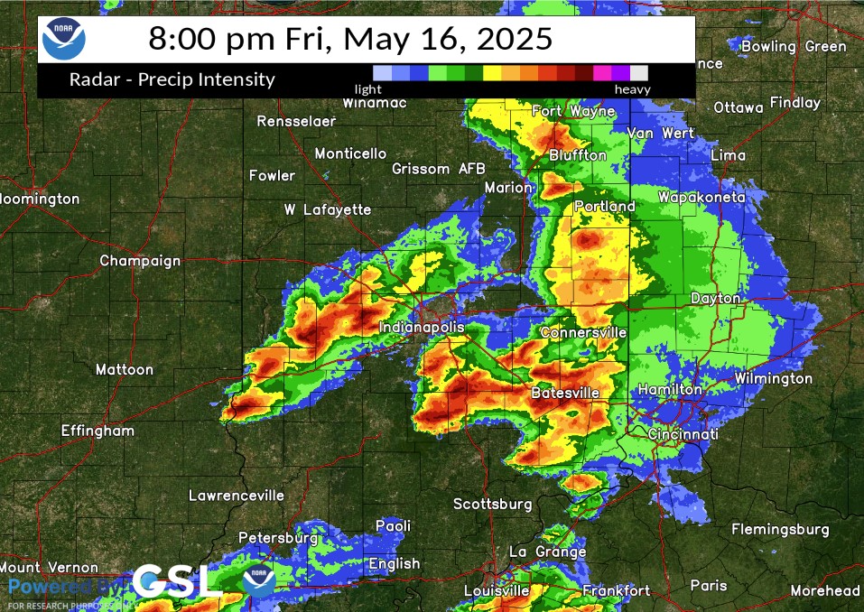
Radar
Selected overview images from the event. A loop is available.
 |
 |
 |
 |
| Radar at 6:00 PM EDT | Radar at 7:00 PM EDT | Radar at 8:00 PM EDT | Radar at 9:00 PM EDT |
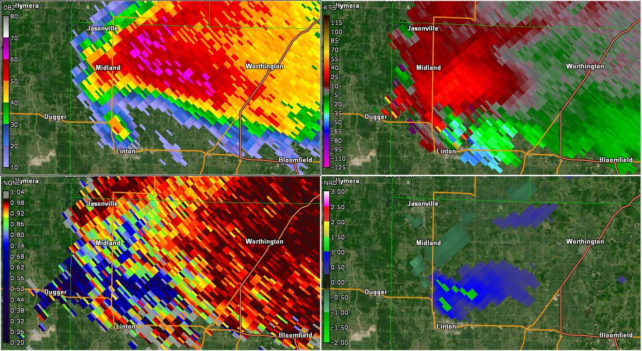
Selected Zoomed-In Radar Images
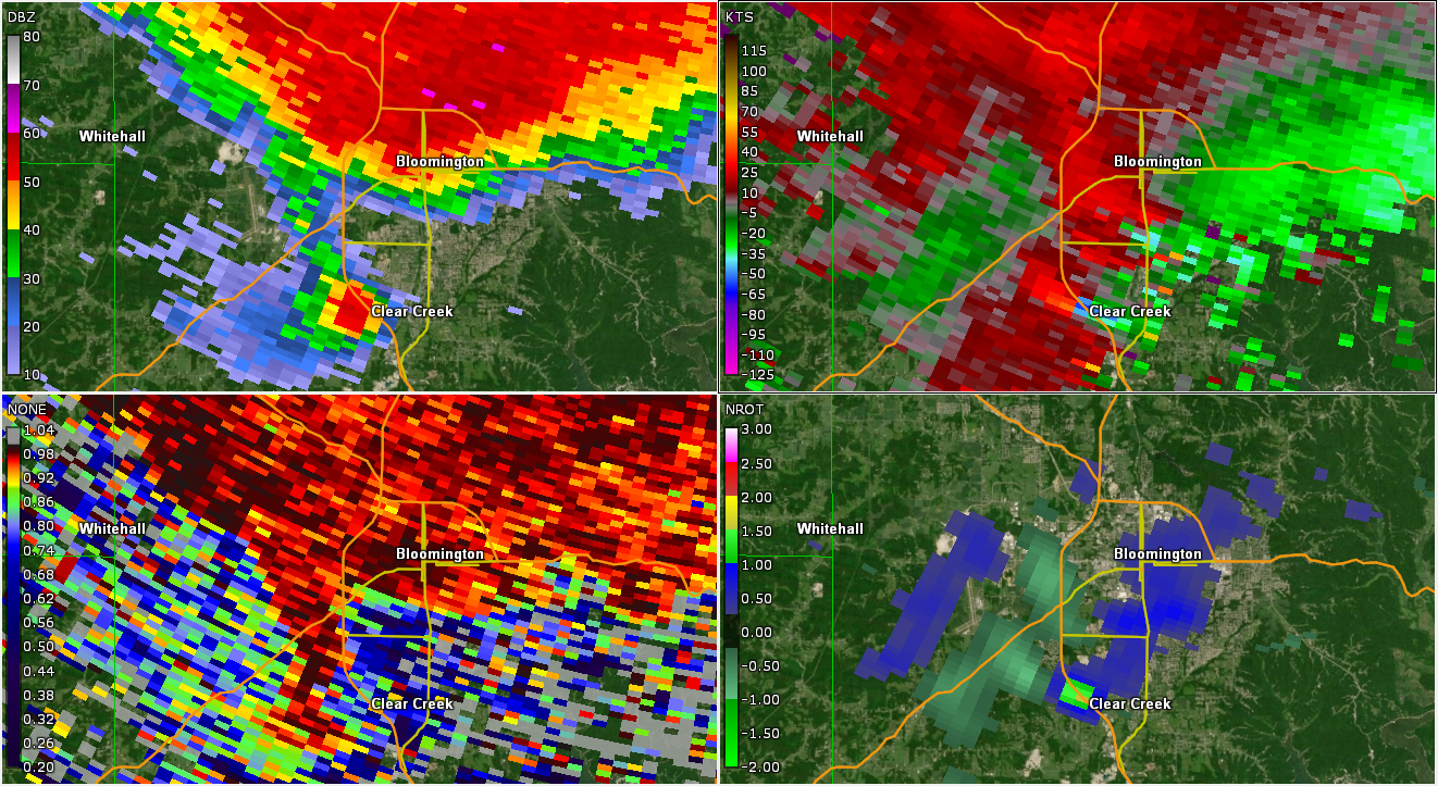
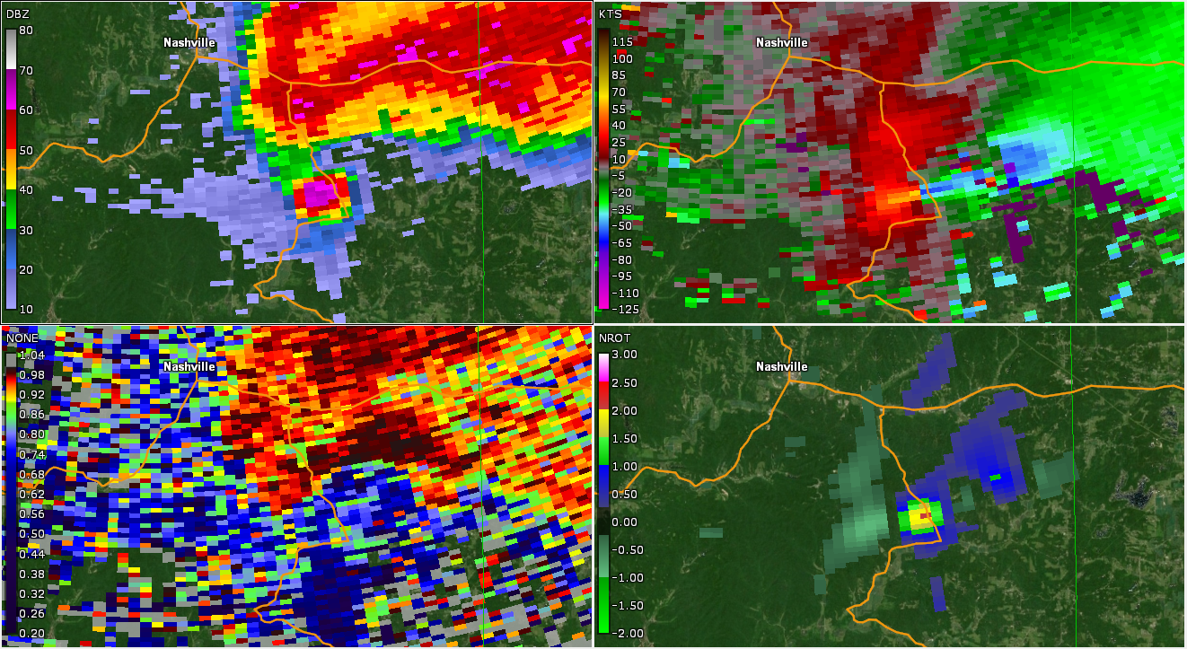
All images: Clockwise from Upper Left: Radar, Storm Relative Velocity, Normalized Rotation, Correlation Coefficient
 |
 |
 |
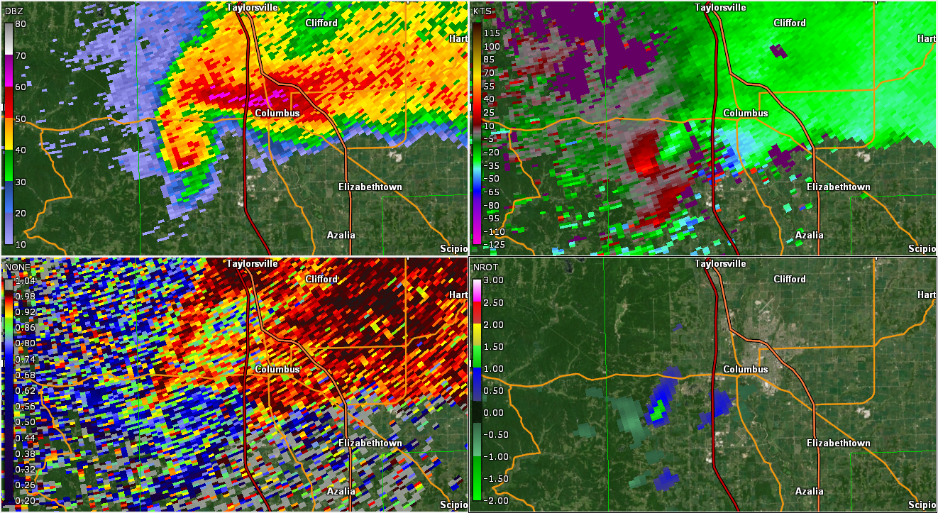 |
| Near Linton | Near Bloomington | Near Nashville | Near Columbus |
Environment
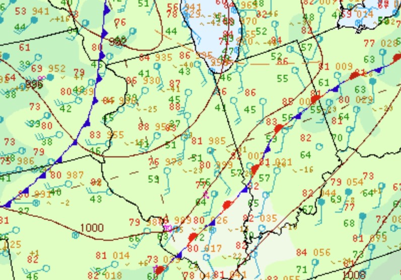
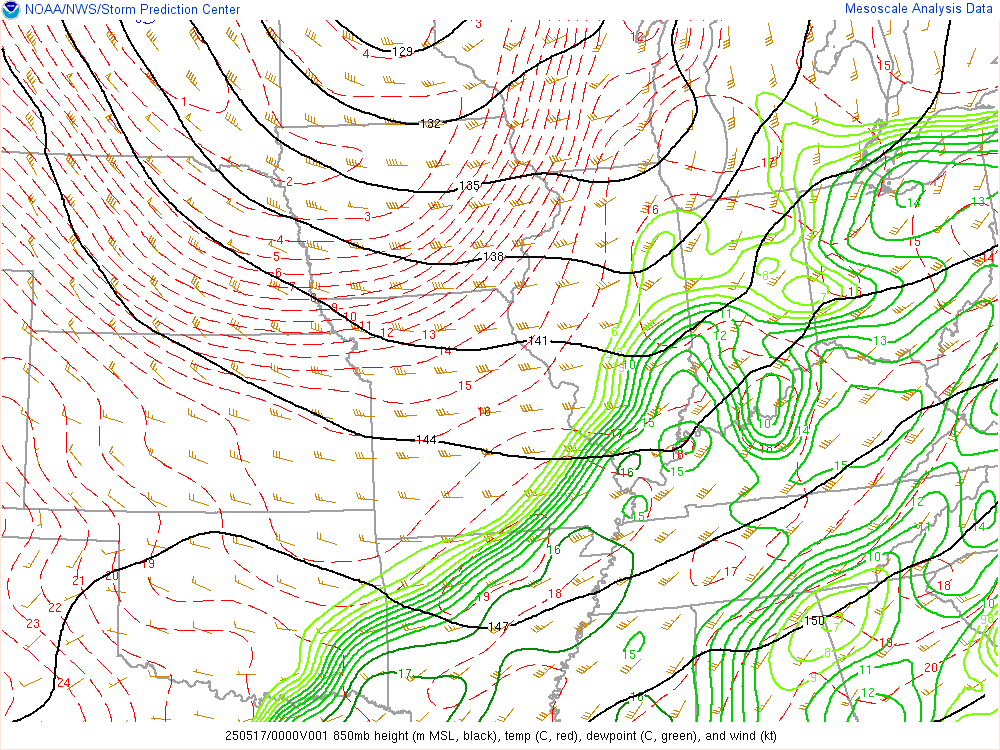
Storms developed near a surface boundary and ahead of an upper trough. An increasing 850mb jet brought in better moisture for the storms.
 |
 |
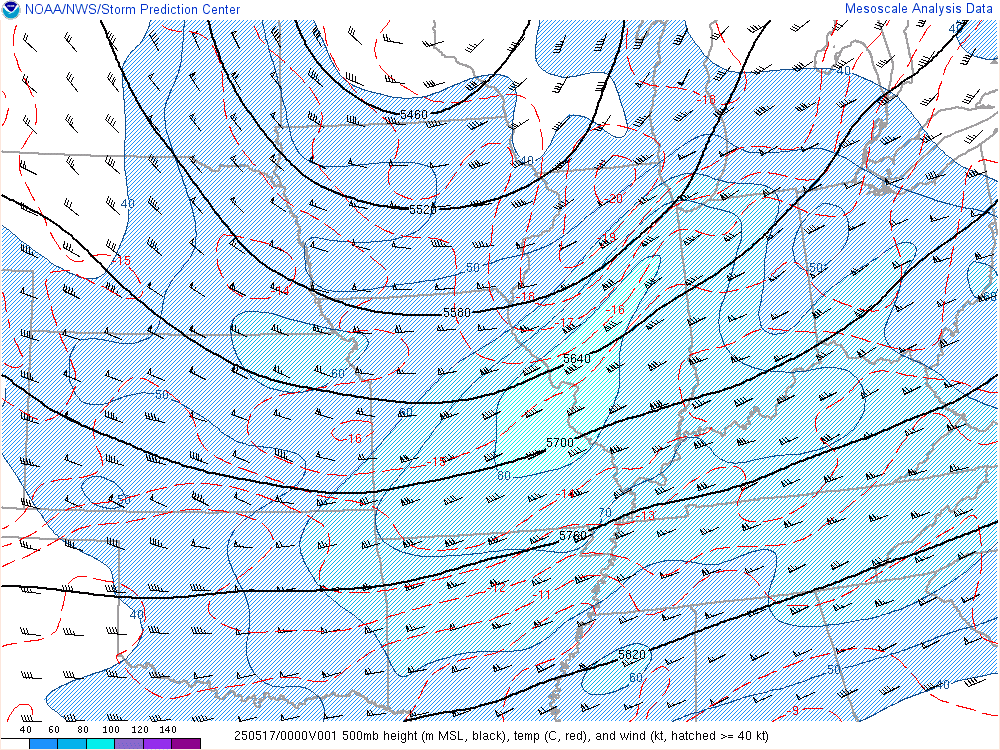 |
| Figure 1: Zoomed-in Surface Map at 5:00 PM EDT | Figure 2: 850mb Analysis at 8:00 PM EDT | Figure 3: 500mb Analysis at 8:00 PM EDT |
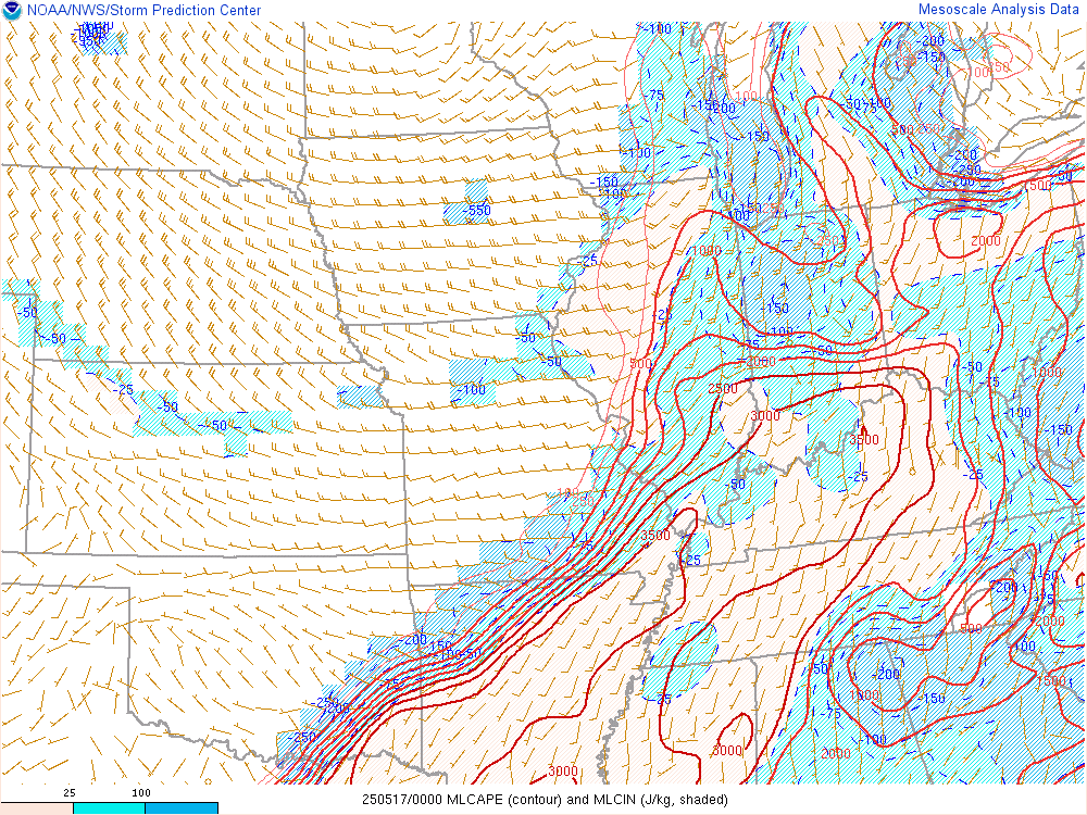
Near-storm environment summary.
 |
 |
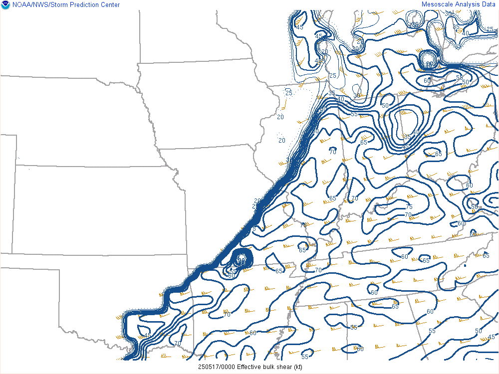 |
| Figure 4: 3 Hour Dewpoint Change at 7 PM EDT | Figure 5: Mixed Layer CAPE at 8 PM EDT | Figure 6: Effective Shear at 8 PM EDT |
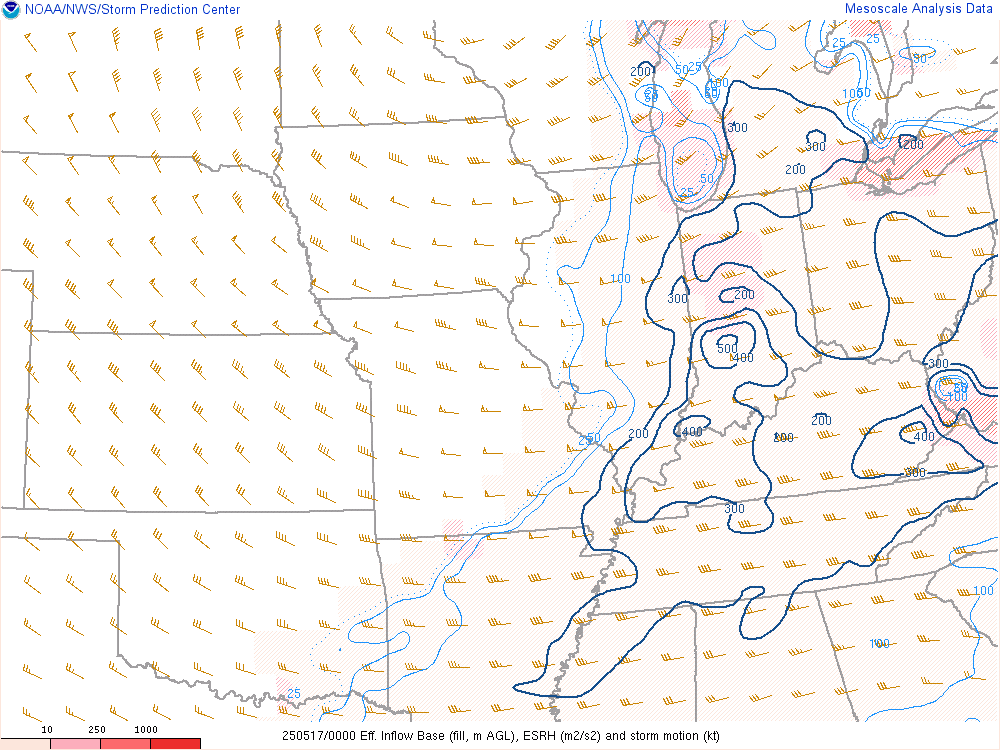
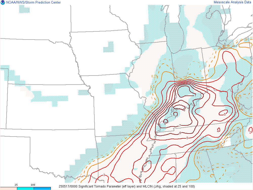
Additional environmental data.
 |
 |
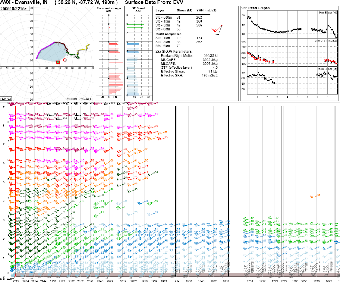 |
| Figure 7: Effective Storm Relative Helicity at 8 PM EDT | Figure 8: Significant Tornado Parameter at 8 PM EDT | Figure 9: Wind Profile/Hodograph from the Evansville Radar (KVWX) at 6:15 PM EDT |
Additional
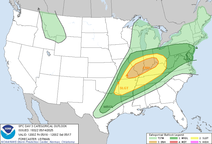
The Forecast
 |
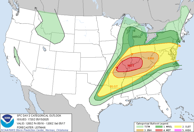 |
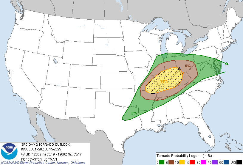 |
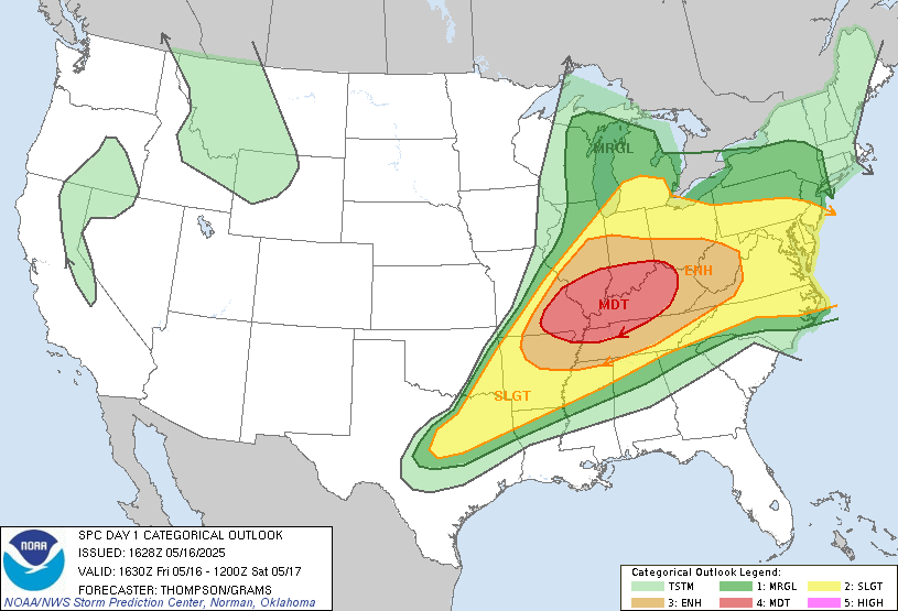 |
| SPC Day 3 Outlook | SPC Day 2 Outlook | SPC Day 2 Probabilistic Outlook | SPC Day 1 Outlook |
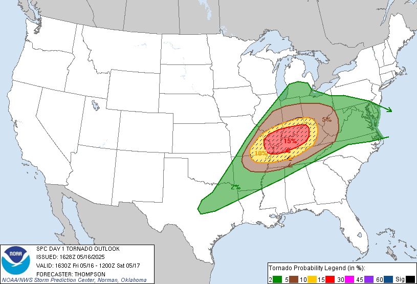 |
 |
 |
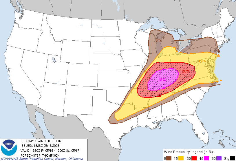
 |
| SPC Day 1 Tornado Outlook | SPC Day1 Wind Outlook | SPC Day1 Hail Outlook | Slide from NWS Indianapolis Packet issued Afternoon of May 15 |
Summaries from other NWS Offices
 |
Media use of NWS Web News Stories is encouraged! Please acknowledge the NWS as the source of any news information accessed from this site. |
|

