Tropical Depression Two is expected to gradually strengthen and could bring tropical storm conditions to the Florida Panhandle beginning late Monday. Areas of flash flooding will be possible through Thursday along the eastern and central Gulf Coast. Severe thunderstorms will develop and move along a cold front crossing the Upper Midwest Monday, and through the Ohio Valley/Mid-Atlantic on Tuesday. Read More >
|
|
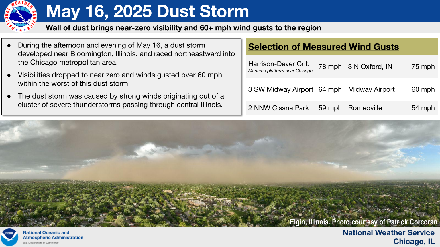
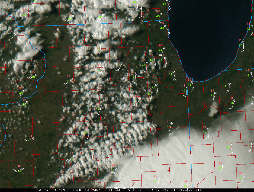
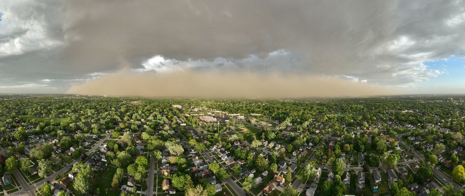
(Click to enlarge loop) GOES-19 Visible "True Color" satellite imagery loop of the dust storm (courtesy of the College of DuPage: https://weather.cod.edu/satrad). |
Overview
For detailed information about this event, see The Midwest Dust Storm of 16 May 2025, a NWS Technical Paper which details the progression of the dust storm, observed weather conditions, and impacts.
Warnings and Additional Items
 |
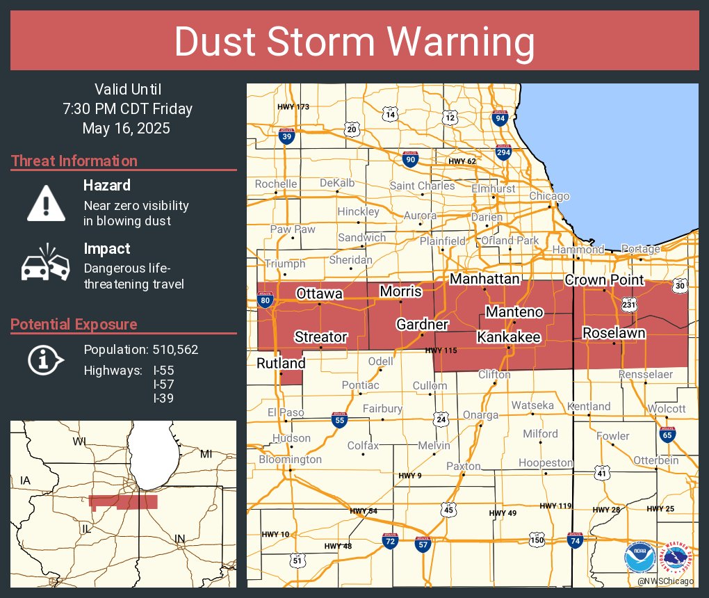 |
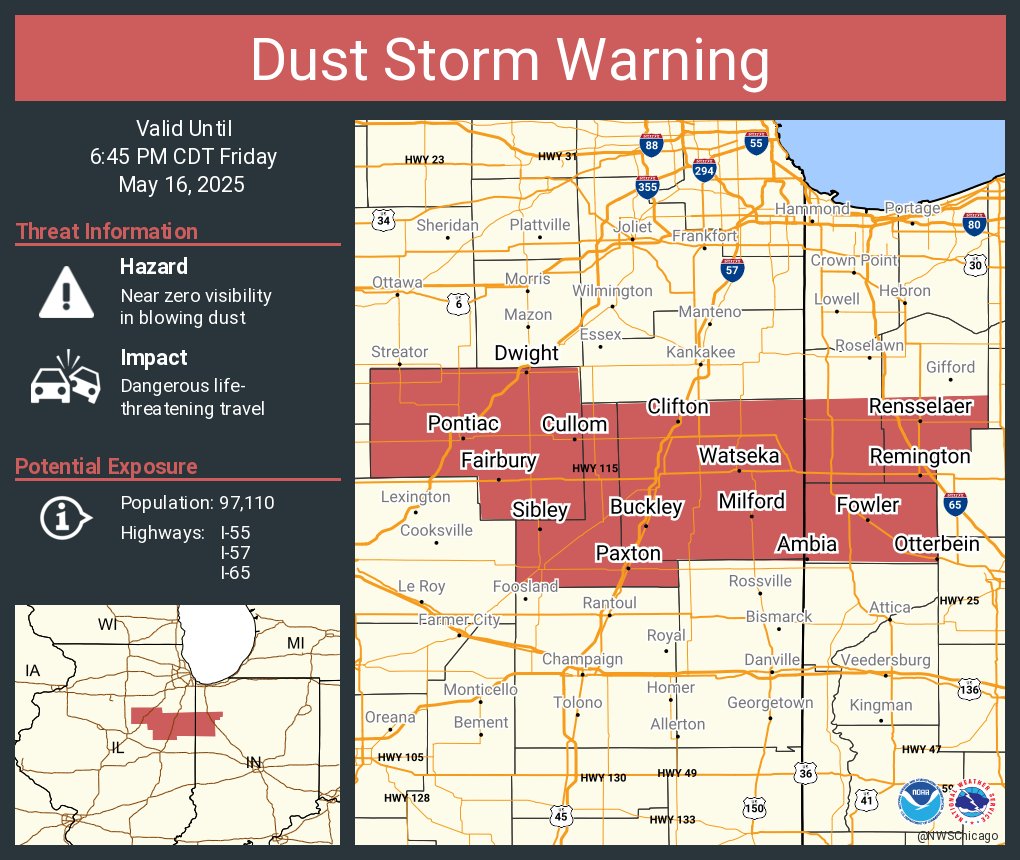
| First Dust Storm Warning issued at 4:48 PM CDT | Second Dust Storm Warning issued at 5:32 PM CDT |
 |
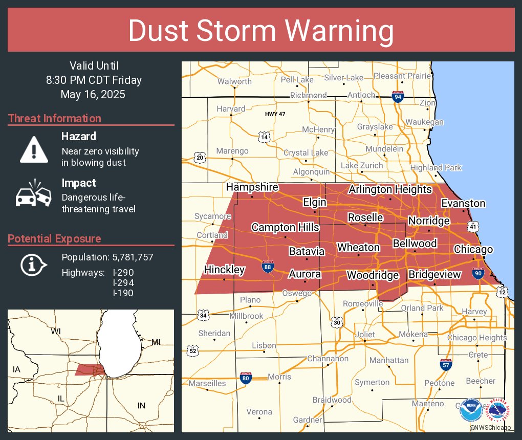 |
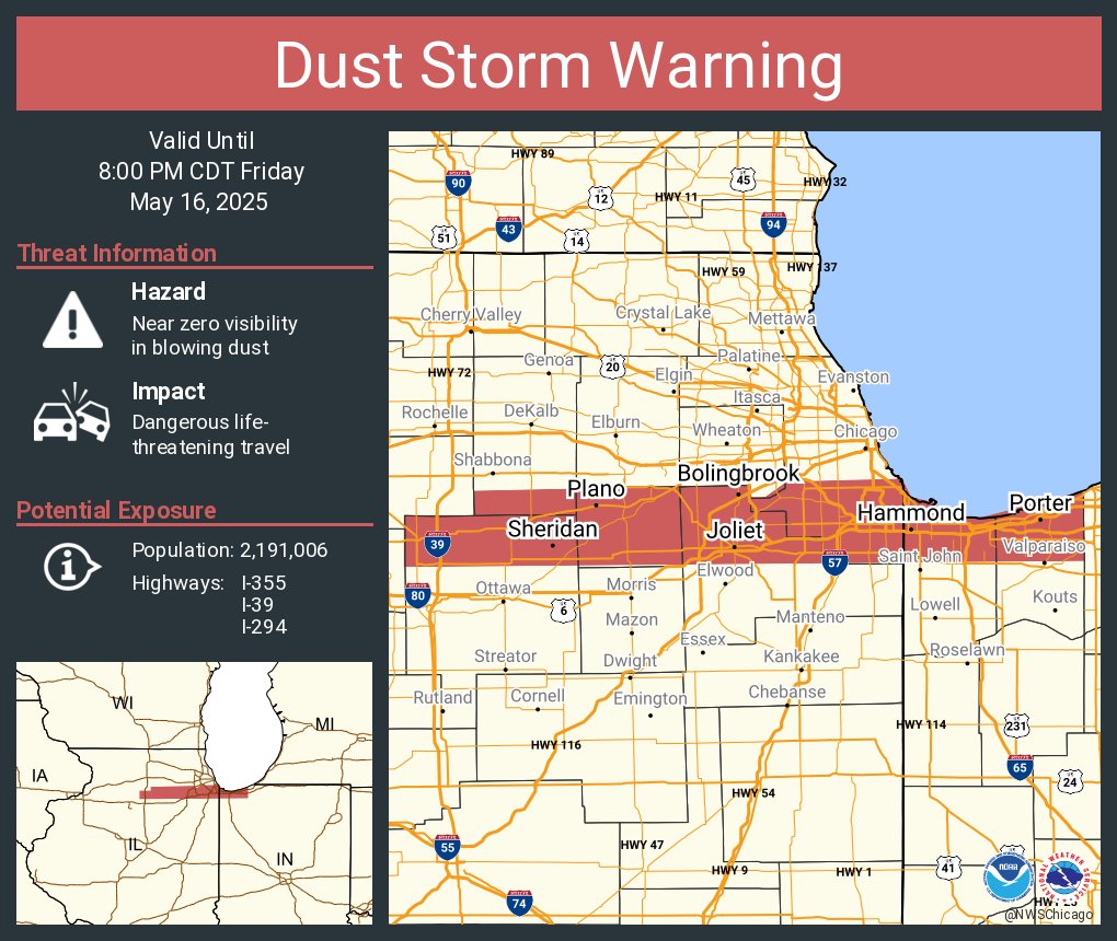
| Third Dust Storm Warning issued at 6:00 PM CDT | Fourth (and final) Dust Storm Warning issued at 6:23 PM CDT |
 |
| An unusual surface observation taken at O'Hare Airport at 7:05 PM CDT. This observation indicates a southwest wind gusting to 43 knots (50 mph) and 1/2 mile visibility with both a dust storm and thunderstorm ongoing at the same time! |
Storm Reports
|
Map showing the observed and estimated minimum visibilities observed during the May 16, 2025, dust storm. |
|
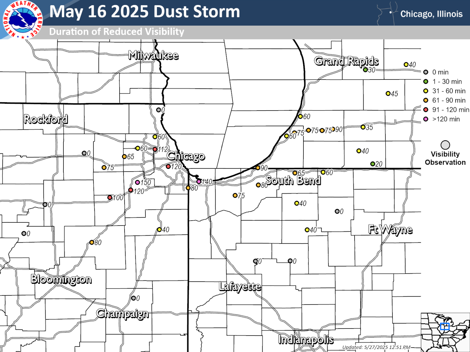
Map showing the duration of time that visibilities were reduced due to the May 16, 2025, dust storm event. |
Preliminary Local Storm Report...Summary
National Weather Service Chicago IL
852 PM CDT Sat May 17 2025
..TIME... ...EVENT... ...CITY LOCATION... ...LAT.LON...
..DATE... ....MAG.... ..COUNTY LOCATION..ST.. ...SOURCE....
..REMARKS..
0505 PM Tstm Wnd Gst 5 SW Clarence 40.40N 88.02W
05/16/2025 M54 MPH Ford IL Public
Private weather station reported 54 mph gust
southeast of Paxton.
0510 PM Tstm Wnd Dmg Paxton 40.46N 88.09W
05/16/2025 Ford IL Emergency Mngr
Power lines downed on East Patton Street in
Paxton. Time estimated.
0513 PM Tstm Wnd Dmg 1 NE Gibson City 40.47N 88.37W
05/16/2025 Ford IL Emergency Mngr
Emergency manager reports tree in roadway
near Melvin Street and 15th Street in Gibson
City.
0514 PM Dust Storm 3 W Sibley 40.59N 88.44W
05/16/2025 Ford IL Emergency Mngr
3 vehicle accident at IL-165 and 100 E Road
west of Sibley due to dust storm. Zero
visibility at time of report.
0516 PM Tstm Wnd Gst 2 NNW Cissna Park 40.59N 87.91W
05/16/2025 M59 MPH Iroquois IL Public
Private weather station reported 59 mph gust
near Cissna Park.
0520 PM Dust Storm Ambia 40.49N 87.52W
05/16/2025 Benton IN Emergency Mngr
Emergency management reports zero visibility
in Ambia due to dust storm.
0520 PM Dust Storm 2 S Boswell 40.48N 87.38W
05/16/2025 Benton IN Emergency Mngr
Emergency management reports zero visibility
along US-41 near 850 South Road south of
Boswell due to dust storm.
0520 PM Tstm Wnd Gst Ambia 40.49N 87.52W
05/16/2025 M65 MPH Benton IN Emergency Mngr
Emergency management reported 65 mph wind
gust with leading edge of dust storm.
0521 PM Blowing Dust 5 NNE Ambia 40.57N 87.49W
05/16/2025 Benton IN Public
Photo shared by Benton County emergency
management shows significantly reduced
visibility due to blowing dust near
Dunnington.
0521 PM Tstm Wnd Gst 5 NNE Ambia 40.56N 87.49W
05/16/2025 M70 MPH Benton IN Emergency Mngr
Corrects previous non-tstm wnd gst report
from 5 NNE Ambia. 70 mph gust measured near
Dunnington. Wind gust occurred along the
leading edge of a dust storm.
0524 PM Tstm Wnd Gst 2 SSW Milford 40.60N 87.72W
05/16/2025 M63 MPH Iroquois IL Public
Private weather station KILMILFO14 reported
63 mph gust near Milford.
0525 PM Tstm Wnd Gst 3 ESE Boswell 40.51N 87.32W
05/16/2025 M57 MPH Benton IN Public
Private weather station reported 57 mph gust
near Boswell.
0526 PM Dust Storm 1 WNW Buckley 40.60N 88.05W
05/16/2025 Iroquois IL Dept of Highways
IL-DOT roadwday camera shows significantly
reduced visibility due to blowing dust along
I-57 at mile marker 287 near Buckley.
0527 PM Non-Tstm Wnd Dmg Piper City 40.76N 88.18W
05/16/2025 Ford IL Emergency Mngr
Emergency management reports tree downed
onto house near Race Street and Vine Street
in Piper City. Wind gusts associated with
arrival of dust storm.
0529 PM Tstm Wnd Gst Pontiac 40.88N 88.63W
05/16/2025 M54 MPH Livingston IL Public
Private weather station KILPONTI24 reported
54 mph gust in Pontiac.
0530 PM Non-Tstm Wnd Dmg 2 N Crescent City 40.80N 87.86W
05/16/2025 Iroquois IL Cocorahs
Roof shingles peeled off and minor tree
damage. Time estimated.
0534 PM Non-Tstm Wnd Gst 3 SW Iroquois 40.80N 87.62W
05/16/2025 M57 MPH Iroquois IL Public
Private weather station KILSHELD3 reported
57 mph gust between Watseka and Iroquois.
Wind gust occurred during leading edge of
dust storm.
0535 PM Blowing Dust 3 N Pontiac 40.92N 88.62W
05/16/2025 Livingston IL AWOS
1/2 mile visibility and peak wind gust of 52
mph reported by KPNT AWOS as dust storm
moved through.
0535 PM Dust Storm 3 E Pontiac 40.89N 88.57W
05/16/2025 Livingston IL Emergency Mngr
Photo shared by Livingston County emergency
management shows near zero visibility east
of Pontiac due to dust storm.
0535 PM Dust Storm 2 W Clarence 40.46N 88.00W
05/16/2025 Ford IL Emergency Mngr
Near-zero visibility on Route 9 east of
Paxton.
0536 PM Tstm Wnd Dmg Oxford 40.52N 87.25W
05/16/2025 Benton IN Emergency Mngr
Updates previous tstm wnd dmg report from
Oxford. Benton County emergency management
reports large limbs and power lines downed
in and near Oxford.
0537 PM Dust Storm Dwight 41.09N 88.43W
05/16/2025 Livingston IL Trained Spotter
Trained spotter reported less than 1/4 mile
visibility in Dwight as dust storm moved
through.
0539 PM Non-Tstm Wnd Gst 1 SE Kentland 40.76N 87.43W
05/16/2025 M63 MPH Newton IN Public
Private weather station KINKENTL5 reported
63 mph gust near Kentland. Gust occurred
with leading edge of dust storm.
0540 PM Dust Storm Fowler 40.62N 87.32W
05/16/2025 Benton IN Public
IN-DOT camera indicates near zero visibility
on US-41 west of Fowler due to dust storm.
0540 PM Dust Storm 1 W Gilman 40.77N 88.00W
05/16/2025 Iroquois IL Emergency Mngr
Multiple reports of near-zero visibility
received in western portions of Iroquois
County as dust storm moved through.
0540 PM Dust Storm 1 ESE Watseka 40.77N 87.72W
05/16/2025 Iroquois IL Emergency Mngr
Updates previous dust storm report from 1
ESE Watseka. 1/4 mile visibility reported at
the Iroquois County Courthouse in Watseka as
dust storm moved through. A peak gust of 52
mph was also measured during the dust storm.
0540 PM Tstm Wnd Gst 3 N Oxford 40.56N 87.24W
05/16/2025 M75 MPH Benton IN Emergency Mngr
Measured wind gust of 75 mph at Benton
Central High School. Time estimated by
radar.
0542 PM Dust Storm 4 SW Dwight 41.06N 88.47W
05/16/2025 Livingston IL Dept of Highways
IL-DOT traffic camera shows significantly
reduced visibility along I-55 near mile
marker 214 southwest of Dwight due to dust
storm.
0544 PM Tstm Wnd Dmg Fowler 40.62N 87.32W
05/16/2025 Benton IN Emergency Mngr
Trees fell onto 3 homes, with one reported
seriously damaged. In addition, there were
numerous trees downed, 15 power poles
snapped, and other reports of roof and
window damage reported across Benton County.
Time estimated by radar.
0545 PM Dust Storm Kankakee 41.12N 87.87W
05/16/2025 Kankakee IL Public
City of Kankakee web cam shows significant
reduced visibility in downtown Kankakee due
to dust storm.
0551 PM Non-Tstm Wnd Gst Remington 40.77N 87.15W
05/16/2025 M60 MPH Jasper IN Cocorahs
Peak measured wind gust.
0551 PM Dust Storm 3 N Remington 40.81N 87.15W
05/16/2025 Jasper IN Public
Public report of near zero visibility near
US-231 and I-65 due to dust storm north of
Remington.
0554 PM Dust Storm 2 ENE Remington 40.77N 87.12W
05/16/2025 Jasper IN Public
IN-DOT traffic camera shows near zero
visibility along I-65 near mile marker 201
east of Remington due to dust storm.
0557 PM Non-Tstm Wnd Gst 2 NW Plainfield 41.63N 88.23W
05/16/2025 M54 MPH Will IL Public
Private weather station reported 54 mph gust
near Plainfield.
0604 PM Blowing Dust 3 E Roselawn 41.14N 87.27W
05/16/2025 Jasper IN Dept of Highways
IN-DOT traffic camera shows reduced
visibility due due to blowing dust along
I-65 near mile marker 230 near Roselawn.
0605 PM Dust Storm 2 S Mazon 41.22N 88.42W
05/16/2025 Grundy IL Emergency Mngr
Grundy County EMA reported 1/10 mile
visibility across southern parts of Grundy
County with gusts of 45 mph as dust storm
moved through.
0606 PM Dust Storm 4 N Carbon Hill 41.35N 88.30W
05/16/2025 Grundy IL CO-OP Observer
1/4 mile visibility reported as dust storm
moved through.
0606 PM Dust Storm 3 NW Wilmington 41.34N 88.19W
05/16/2025 Will IL Public
IL-DOT traffic camera along I-55 near mile
marker 240 indicates significantly reduced
visibility due to dust storm.
0609 PM Non-Tstm Wnd Gst 2 NNW Manhattan 41.45N 88.00W
05/16/2025 M58 MPH Will IL Public
Private weather station KILMANHA55 reported
58 mph gust near Manhattan. Gust occurred
with leading edge of dust storm.
0610 PM Dust Storm 2 SE Preston Heights 41.47N 88.06W
05/16/2025 Will IL Emergency Mngr
Photo shared by Will County emergency
management shows leading edge of near zero
visibility approaching Chicagoland Speedway
near Joliet.
0611 PM Dust Storm Peotone 41.33N 87.79W
05/16/2025 Will IL Local Official
Visibility of 1/2 mile or less reported in
Peotone as dust storm moved through.
0612 PM Dust Storm 2 NNE Peotone 41.35N 87.78W
05/16/2025 Will IL CO-OP Observer
1/4 to 1/8 mile visibility on Peotone Road
and Route 50 as dust storm moved through.
0617 PM Dust Storm Monee 41.42N 87.76W
05/16/2025 Will IL Public
1/8 mile visibility reported on I-57 in
Monee as dust storm moved through.
0618 PM Blowing Dust 4 NNE Mount Ayr 41.01N 87.28W
05/16/2025 Newton IN Trained Spotter
Photo shows reduced visibility due to
blowing dust near Fair Oaks Farm north of Mt
Ayr.
0620 PM Dust Storm 1 E Tinley Park 41.57N 87.79W
05/16/2025 Cook IL Trained Spotter
Public report of nearly zero visibility in
Tinley Park due to dust storm.
0620 PM Dust Storm Burbank 41.74N 87.77W
05/16/2025 Cook IL Trained Spotter
Near zero visibility.
0622 PM Dust Storm 1 NE Shorewood 41.53N 88.18W
05/16/2025 Will IL Dept of Highways
IL-DOT traffic camera shows near zero
visibility along I-55 just north of
Jefferson Street in Shorewood due to dust
storm.
0627 PM Blowing Dust 1 WNW New Lenox 41.52N 87.99W
05/16/2025 Will IL Dept of Highways
IL-DOT traffic camera shows significantly
reduced visibility along I-80 near mile
marker 137 east of Joliet due to blowing
dust.
0629 PM Blowing Dust 1 WNW Country Club Hill 41.57N 87.74W
05/16/2025 Cook IL Dept of Highways
IL-DOT traffic camera shows significantly
reduced visibility near I-80 and I-57 due to
blowing dust.
0629 PM Dust Storm NWS Chicago-Romeoville 41.60N 88.08W
05/16/2025 Will IL Official NWS Obs
1/4 to 1/2 mile visibility observed at NWS
Chicago office in Romeoville as dust storm
moved through. A peak gust of 54 mph was
recorded by the KLOT AWOS while this
occurred.
0630 PM Blowing Dust 3 WSW Winfield 41.39N 87.32W
05/16/2025 Lake IN Dept of Highways
IN-DOT traffic camera shows reduced
visibility along I-65 near mile marker 247
southeast of Crown Point due to blowing
dust.
0630 PM Blowing Dust 2 SW Schererville 41.48N 87.47W
05/16/2025 Lake IN Public
Multiple IN-DOT traffic cameras show reduced
visibilities in St John, Schererville, and
Dyer due to blowing dust.
0630 PM Blowing Dust 1 E Burbank 41.74N 87.76W
05/16/2025 Cook IL Public
Public report of significantly reduced
visibility due to blowing dust in Burbank.
0635 PM Non-Tstm Wnd Gst 1 NE Lynwood 41.53N 87.53W
05/16/2025 M53 MPH Cook IL AWOS
Peak gust recorded by KIGQ AWOS as dust
storm moved through. Lowest reported
visibility was 1.5 miles.
0635 PM Dust Storm Lemont 41.67N 88.00W
05/16/2025 Cook IL Emergency Mngr
Lemont emergency management indicates
visibility around a quarter mile in Lemont
due to a dust storm.
0635 PM Blowing Dust 1 NNE Countryside 41.79N 87.87W
05/16/2025 Cook IL Public
Visibility below 1 mile due to blowing dust.
Time estimated by radar and satellite.
0635 PM Non-Tstm Wnd Dmg 3 SW Warrenville 41.78N 88.22W
05/16/2025 DuPage IL Public
Large uprooted tree.
0635 PM Non-Tstm Wnd Gst 3.0 SW Midway Airport 41.74N 87.78W
05/16/2025 M64 MPH Cook IL CO-OP Observer
Midway cooperative observer in Burbank
reported peak gust 64 mph during arrival of
dust storm. Time estimated by radar and
satellite.
0638 PM Non-Tstm Wnd Dmg 1 N Hometown 41.74N 87.73W
05/16/2025 Cook IL Public
Photo shared showing large tree branch
downed on the southwest side of Chicago near
Burbank. Time estimated based on nearby wind
observations.
0639 PM Non-Tstm Wnd Gst 1 SW Wheeler 41.50N 87.19W
05/16/2025 M55 MPH Porter IN Public
Private weather station KINWHEEL1 reported
55 mph gust near Wheeler. Gust occurred with
leading edge of dust storm.
0640 PM Dust Storm Midway Airport 41.79N 87.75W
05/16/2025 Cook IL ASOS
Updates previous blowing dust report from
Midway Airport. Chicago Midway Airport web
cam shows significantly reduced visibility
due to dust storm. Lowest visibility
reported by KMDW ASOS was 1/4 mile.
0640 PM Dust Storm 1 SSE Alsip 41.66N 87.73W
05/16/2025 Cook IL Emergency Mngr
Visibility around 1/4 mile.
0640 PM Non-Tstm Wnd Gst Midway Airport 41.79N 87.75W
05/16/2025 M60 MPH Cook IL ASOS
Peak gust recorded by MDW ASOS as dust storm
moved through.
0644 PM Non-Tstm Wnd Gst 3 ESE Valparaiso 41.45N 87.01W
05/16/2025 M52 MPH Porter IN ASOS
Peak gust recorded by KVPZ ASOS as dust
storm moved through. Lowest reported
visibility was 1.75 miles.
0650 PM Non-Tstm Wnd Gst DuPage Airport 41.91N 88.25W
05/16/2025 M52 MPH DuPage IL ASOS
Peak gust recorded by KDPA ASOS as dust
storm moved through. Lowest reported
visibility was 2 miles.
0650 PM Blowing Dust 2 WNW Sugar Grove 41.77N 88.47W
05/16/2025 Kane IL ASOS
1 mile visibility reported by KARR ASOS as
dust storm moved through.
0650 PM Dust Storm Berwyn 41.84N 87.79W
05/16/2025 Cook IL Trained Spotter
Trained spotter reports quarter mile
visibility in Berwyn due to dust storm.
0651 PM Hail Rockford Airport 42.20N 89.10W
05/16/2025 M1.00 Inch Winnebago IL Official NWS Obs
0652 PM Marine Tstm Wind 3 NE Navy Pier 41.92N 87.57W
05/16/2025 M78 MPH LMZ741 IL Public
Harrison Dever Crib reported 78 mph gust.
Gust was associated with the leading edge of
a dust storm.
0655 PM Blowing Dust 1 SE Maywood 41.87N 87.83W
05/16/2025 Cook IL Public
IL-DOT traffic camera shows reduced
visibility along I-290 near IL-171 in
Maywood due to blowing dust.
0700 PM Blowing Dust 1 S Chicago Loop 41.87N 87.63W
05/16/2025 Cook IL Public
Photo shared to social media shows
significantly reduced visibility in south
loop of Chicago due to blowing dust.
0700 PM Hail Cherry Valley 42.24N 88.96W
05/16/2025 E1.00 Inch Winnebago IL Public
0700 PM Marine Tstm Wind 3 NE Beverly Shores 41.72N 86.94W
05/16/2025 M51 MPH LMZ745 IN Public
Peak gust of 44.9 kt at Michigan City GLERL
site.
0705 PM Blowing Dust OHare Airport 41.96N 87.93W
05/16/2025 DuPage IL ASOS
1/2 mile visibility and peak wind gust of 46
mph reported by KORD ASOS as dust storm
moved through.
0705 PM Hail 1 W Belvidere 42.26N 88.86W
05/16/2025 M0.70 Inch Boone IL Public
Public report of dime size hail near
Belvidere.
0708 PM Dust Storm Wheaton 41.87N 88.11W
05/16/2025 DuPage IL Public
Around 1/4 mile visibility estimated in
Wheaton as dust storm moved through.
0715 PM Blowing Dust 1 SE Northfield 42.08N 87.76W
05/16/2025 Cook IL Public
Public report of visibility reduced to about
half a mile in Northfield due to blowing
dust. Time estimated by radar and satellite.
0719 PM Blowing Dust Palatine 42.11N 88.03W
05/16/2025 Cook IL Fire Dept/Rescue
3/4 mile visibility and a peak gust of 53
mph reported in Palatine as dust storm moved
through.
&&
$$
|
Photos
 |
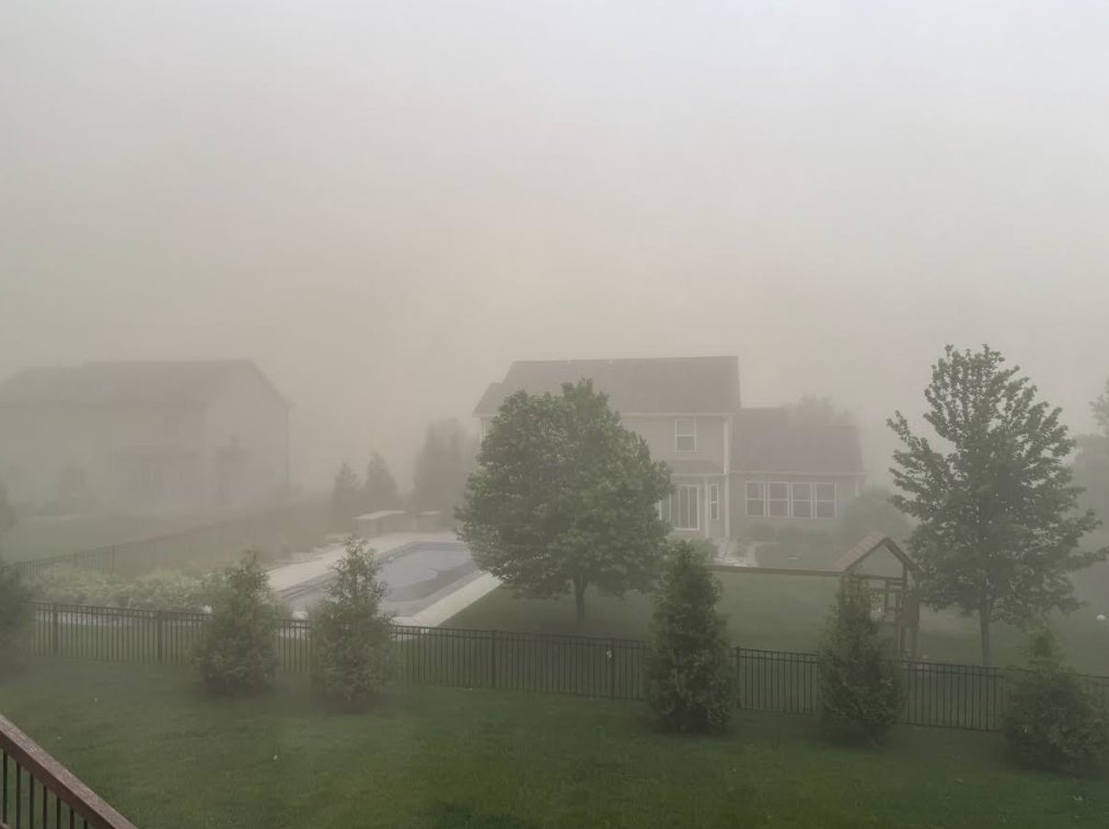
||
| Elgin, Illinois. Photo courtesy of Patrick Corcoran. |
 |
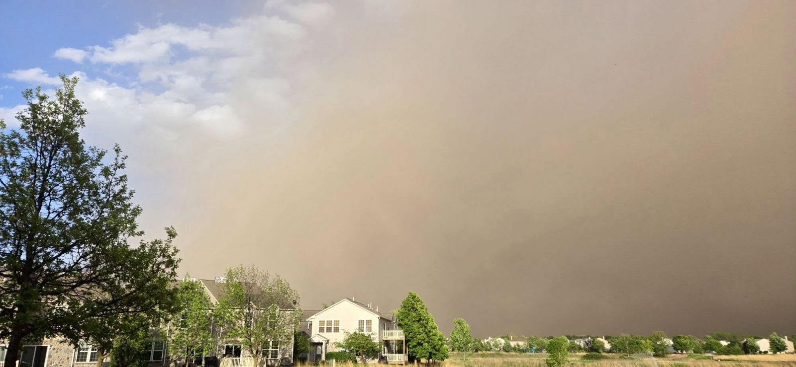
 |
| Dust storm approaching Bloomington, Illinois. Photo courtesy of Jason Borchardt. | Dust storm in Bloomington, Illinois. Photo courtesy of Jason Borchardt. |
|
|
|
|
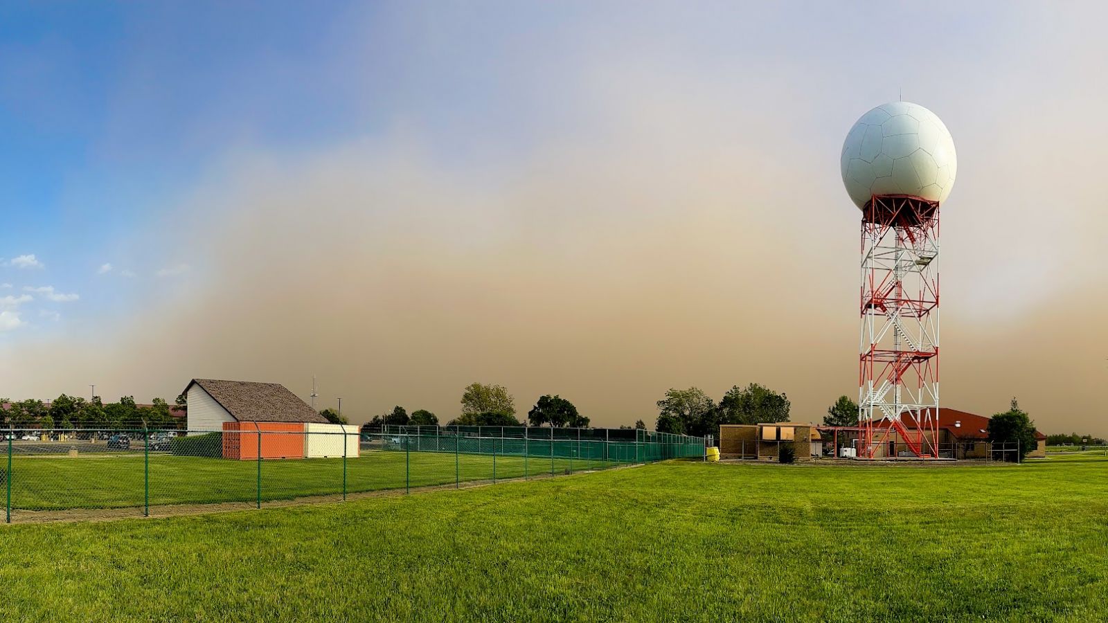
| NWS Chicago Office, Romeoville, Illinois. | Momence, Illinois. Photo courtesy of Kathy Kelly. | |
 |
||
| Lockport, Illinois. Photo courtesy of Stacey Kruse. |
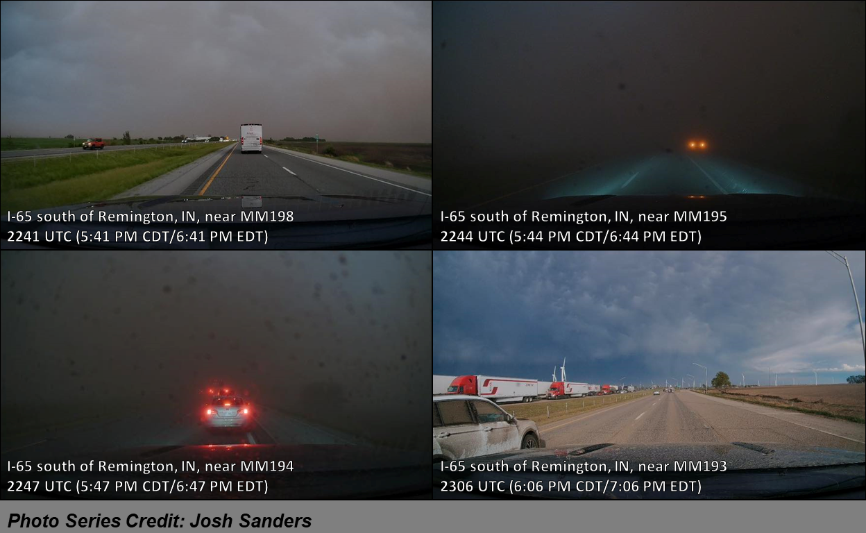 |
||
| Photo series from a dash cam showing near-zero visibility in the dust storm along I-65 south of Remington, Indiana. Photos courtesy of Josh Sanders. |
Additional Information
Links:
 |
Media use of NWS Web News Stories is encouraged! Please acknowledge the NWS as the source of any news information accessed from this site. Additional event recaps can be found on the NWS Chicago Past Events Page |
|