Fast Facts
|
|
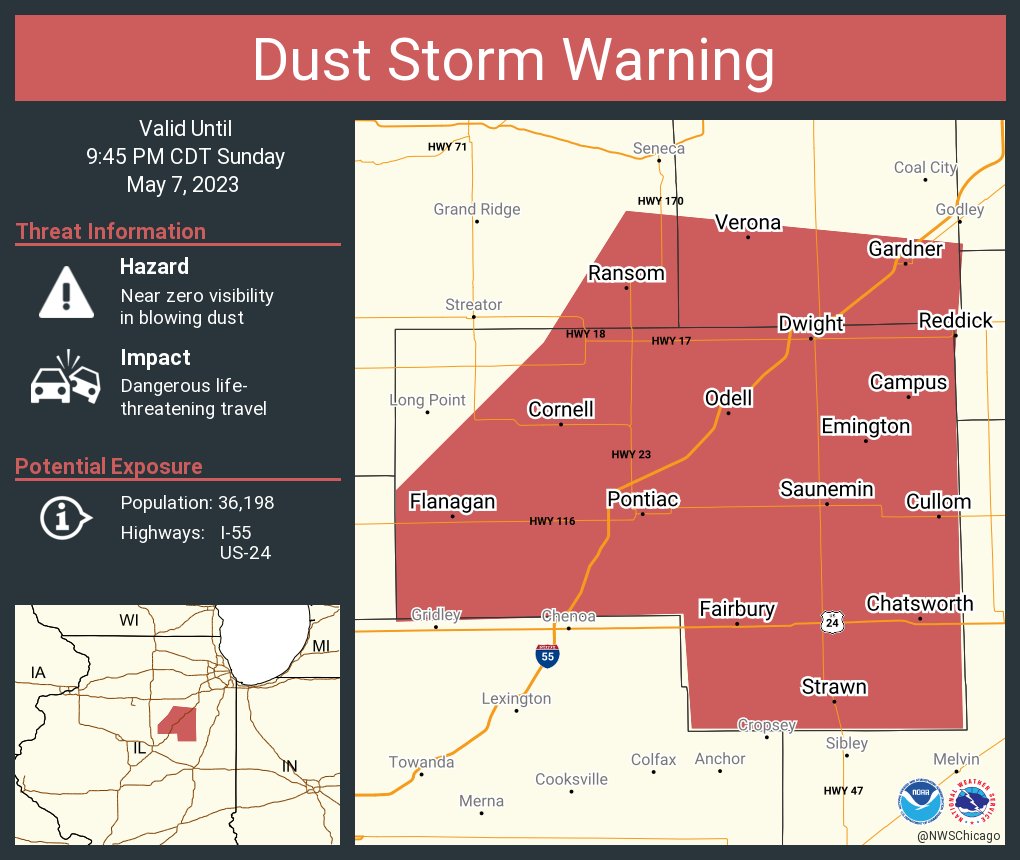
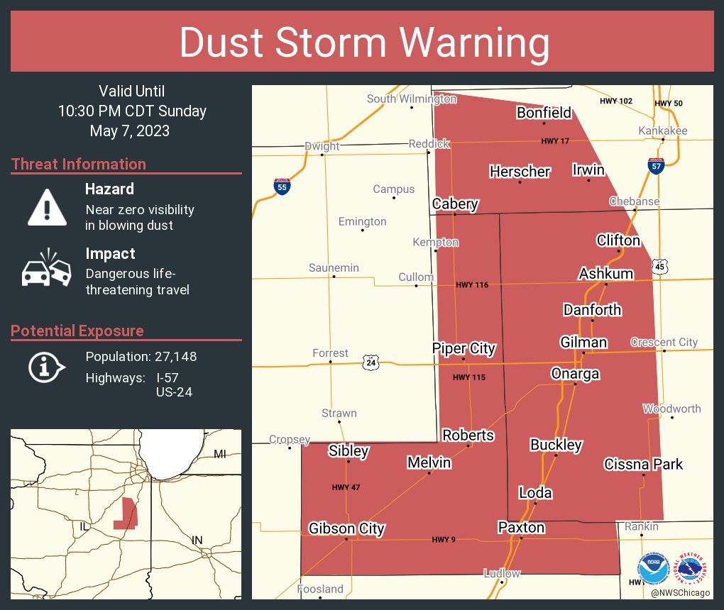
Blowing Dust and Dust Storm Warnings
|
|
 |
|
| First Dust Storm Warning issued at 8:47 PM CDT | Second Dust Storm Warning issued at 9:06 PM CDT |
https://twitter.com/jacobdickeywx/status/1655402842750955520
Photos
 |
 |
 |
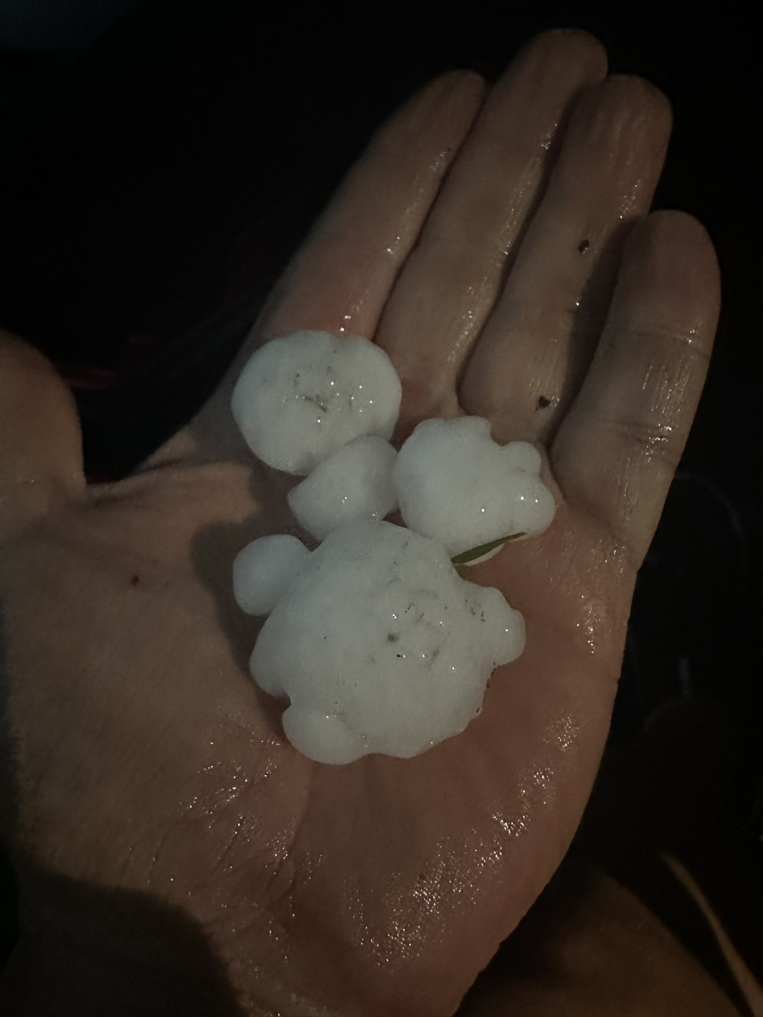
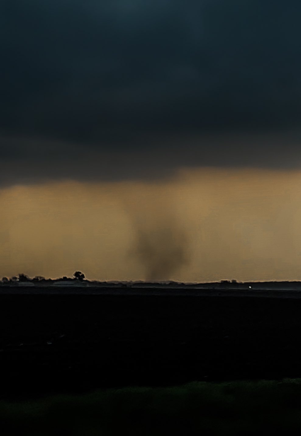
| Large hailstones from near Lisbon, IL. Photo courtesy of Eddie via Twitter. | Photo of a landspout tornado near Serena, IL. Photo courtesy of Landon Moeller. | Wind damage in Chatsworth, IL. Photo courtesy of Bruce Sanders. |
Storm Reports
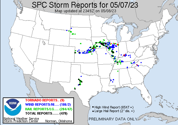 |
PRELIMINARY LOCAL STORM REPORT...SUMMARY
NATIONAL WEATHER SERVICE CHICAGO IL
1122 PM CDT MON MAY 8 2023
..TIME... ...EVENT... ...CITY LOCATION... ...LAT.LON...
..DATE... ....MAG.... ..COUNTY LOCATION..ST.. ...SOURCE....
..REMARKS..
0630 PM Tornado 1 SSE Grant Park 41.23N 87.64W
05/07/2023 Kankakee IL Public
Corrects location of previous tornado report
from 1 SSE Sun River Terrace. Video shared
of landspout-type tornado kicking up dust in
a field southwest of Route 1 and Route 17
near Grant Park.
0645 PM Tornado 3 SW Grant Park 41.21N 87.68W
05/07/2023 Kankakee IL Public
A second landspout tornado touched down in
the Grant Park area between Grant Park and
Momence along Route 1/17. This landspout was
on the ground for about 4 minutes and threw
a vehicle into a ditch but did not cause any
known damage to structures or trees.
0700 PM Hail 1 N Mendota 41.56N 89.12W
05/07/2023 M1.00 inch La Salle IL Public
Relayed by off-duty meteorologist. Time
estimated.
0705 PM Hail Lake Village 41.14N 87.45W
05/07/2023 M1.75 inch Newton IN Public
Corrects previous hail report from Lake
Village.
0709 PM Tornado 3 SW Serena 41.47N 88.75W
05/07/2023 La Salle IL Public
Landspout.
0730 PM Hail Manteno 41.25N 87.84W
05/07/2023 E0.70 inch Kankakee IL Trained Spotter
5 minutes of dime hail.
0732 PM Hail 1 S Lisbon 41.46N 88.48W
05/07/2023 E1.75 inch Kendall IL Public
Photo shared on social media. Location
estimated. Time based on phone timestamp.
0739 PM Hail 1 N Momence 41.17N 87.66W
05/07/2023 U1.00 inch Kankakee IL Public
Report from mPING: Quarter (1.00 in.).
0801 PM Hail 2 N Morris 41.38N 88.43W
05/07/2023 U0.75 inch Grundy IL Public
Report from mPING: Dime (0.75 in.).
0824 PM Tstm Wnd Gst 3 ENE Lostant 41.16N 89.02W
05/07/2023 E62 MPH La Salle IL Public
Private weather station gusting 55-60 mph
for more than 10 minutes. Peak of 62 mph.
Winds were just out ahead of the main line
of storms.
0824 PM Tstm Wnd Dmg Lostant 41.14N 89.07W
05/07/2023 La Salle IL Fire Dept/Rescue
Power lines and large tree limbs downed in
and near Lostant. Also shingle and siding
damage reported to some homes.
0830 PM Tstm Wnd Dmg 1 N Streator 41.14N 88.84W
05/07/2023 La Salle IL Trained Spotter
Along North Bloomington Road, railroad
crossing gates snapped and some trees down.
0830 PM Dust Storm 2 SSW Lostant 41.12N 89.08W
05/07/2023 La Salle IL Law Enforcement
Reports of near-0 visibility due to blowing
dust at I-39 by Route 18 between
approximately mile posts 40 to 43. Relayed
by Pontiac Comms Center/ISP. Time estimated
based on radar.
0835 PM Tstm Wnd Dmg 2 E Kangley 41.15N 88.83W
05/07/2023 La Salle IL Trained Spotter
Reports of multiple road and parking signs
bent at nearly 45 degree angles. Time
estimated based on radar.
0839 PM Tstm Wnd Gst 1 N Rutland 41.00N 89.04W
05/07/2023 M58 MPH La Salle IL Public
Gust measured at a private weather station.
0845 PM Dust Storm 2 E Kangley 41.15N 88.84W
05/07/2023 La Salle IL Emergency Mngr
Multiple reports of near 0 or 0 visibility
just north of Streator. Reports replayed by
La Salle EM. Time estimated.
0849 PM Tstm Wnd Gst 5 ENE Streator 41.15N 88.75W
05/07/2023 M51 MPH La Salle IL Public
Measured by personal weather station
KILSTREA21.
0854 PM Tstm Wnd Gst 6 E Grand Ridge 41.24N 88.72W
05/07/2023 M56 MPH La Salle IL Public
Measured by personal weather station
KILGRAND10.
0857 PM Hail 4 NW Wilmington 41.34N 88.19W
05/07/2023 E1.00 inch Will IL Trained Spotter
Multiple hailstones at least quarter sized.
Also standing water several inches deep on
SE Frontage Road.
0900 PM Flood 4 NNE Wedron 41.49N 88.75W
05/07/2023 La Salle IL Emergency Mngr
A few inches of standing water reported on
the westbound lane of US Route 52 near
Serena.
0914 PM Tstm Wnd Gst 3 NW Verona 41.25N 88.55W
05/07/2023 M53 MPH Grundy IL Public
Measured from personal weather station
KILVERON5, gusting from the east just prior
to thunderstorms.
0936 PM Hail 1 N Morocco 40.96N 87.45W
05/07/2023 U1.25 inch Newton IN Public
Report from mPING: Half Dollar (1.25 in.).
0937 PM Hail 4 NNW Morocco 41.00N 87.49W
05/07/2023 M1.00 inch Newton IN Public
0957 PM Tstm Wnd Dmg 4 E Saunemin 40.89N 88.34W
05/07/2023 Livingston IL Broadcast Media
Multiple power lines down and a damaged shed
between Saunemin and Cullom. Location and
time estimated from radar.
1000 PM Tstm Wnd Dmg Cullom 40.88N 88.27W
05/07/2023 Livingston IL Law Enforcement
Pontiac Comms Center relayed tree damage in
the town of Cullom on Route 116.
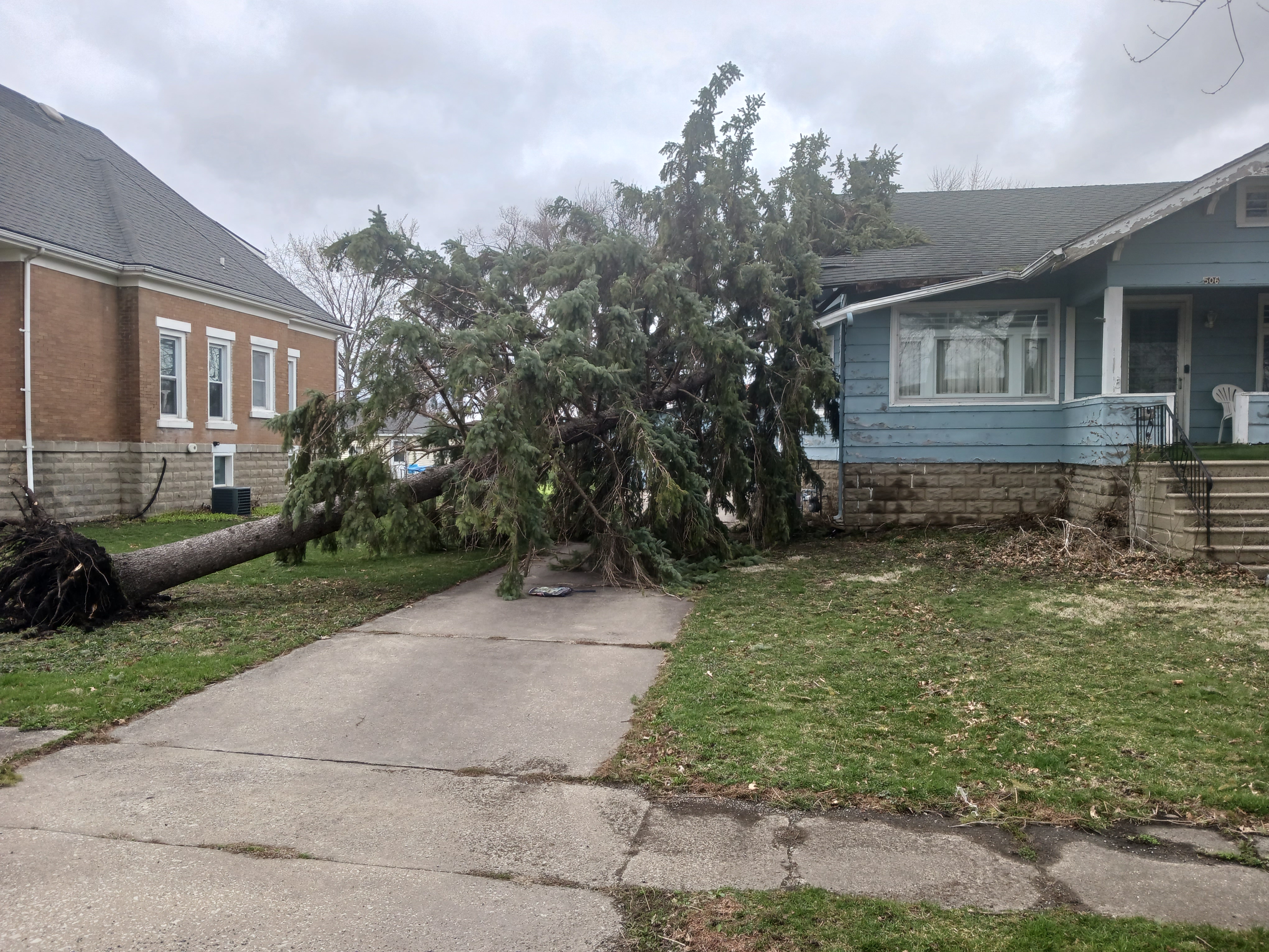
1014 PM Tstm Wnd Dmg Chatsworth 40.75N 88.29W
05/07/2023 Livingston IL Trained Spotter
Multiple live trees downed on Locust and N
5th street in Chatsworth. Time estimated
based on radar.
1014 PM Non-Tstm Wnd Gst 4 SSW Dixon 41.78N 89.50W
05/07/2023 M54 MPH Lee IL Public
Corrects previous report from 4 SSW Dixon.
Winds behind the thunderstorms, measured by
KILDIXON41.
1015 PM Tstm Wnd Gst Chatsworth 40.75N 88.29W
05/07/2023 M65 MPH Livingston IL CO-OP Observer
Time estimated. Numerous limbs down, one 4-5
inch diameter limb downed onto a car.
1018 PM Tstm Wnd Dmg Piper City 40.76N 88.19W
05/07/2023 Ford IL Emergency Mngr
Numerous trees downed in and near Piper
City, including one onto a house. Time
estimated from radar.
1020 PM Non-Tstm Wnd Dmg Dixon 41.84N 89.48W
05/07/2023 Lee IL Emergency Mngr
Multiple reports of trees downed by
non-thunderstorm winds in Dixon roughly
between 10 and 11 PM.
1050 PM Tstm Wnd Dmg Paxton 40.46N 88.10W
05/07/2023 Ford IL Broadcast Media
Tree snapped about halfway up and downed
onto power lines. Relayed by WCIA. Time
estimated based on peak winds at nearby
personal weather stations.
1059 PM Non-Tstm Wnd Gst 4 S Compton 41.64N 89.09W
05/07/2023 M48 MPH Lee IL Mesonet
Southeast winds associated with wake low.
1119 PM Non-Tstm Wnd Gst 3 NNW Sheridan 41.57N 88.71W
05/07/2023 M45 MPH La Salle IL Mesonet
Southeasterly winds associated with wake
low.
1126 PM Non-Tstm Wnd Gst 2 WNW Sugar Grove 41.77N 88.48W
05/07/2023 M46 MPH Kane IL ASOS
Southeast winds associated with wake low.
Measured at KARR.
1154 PM Non-Tstm Wnd Gst 4 S Dixon 41.78N 89.50W
05/07/2023 M58 MPH Lee IL Public
Personal weather station KILDIXON41 reported
a second peak non-thunderstorm wind gust of
58 mph at 11:54 PM CDT.
|
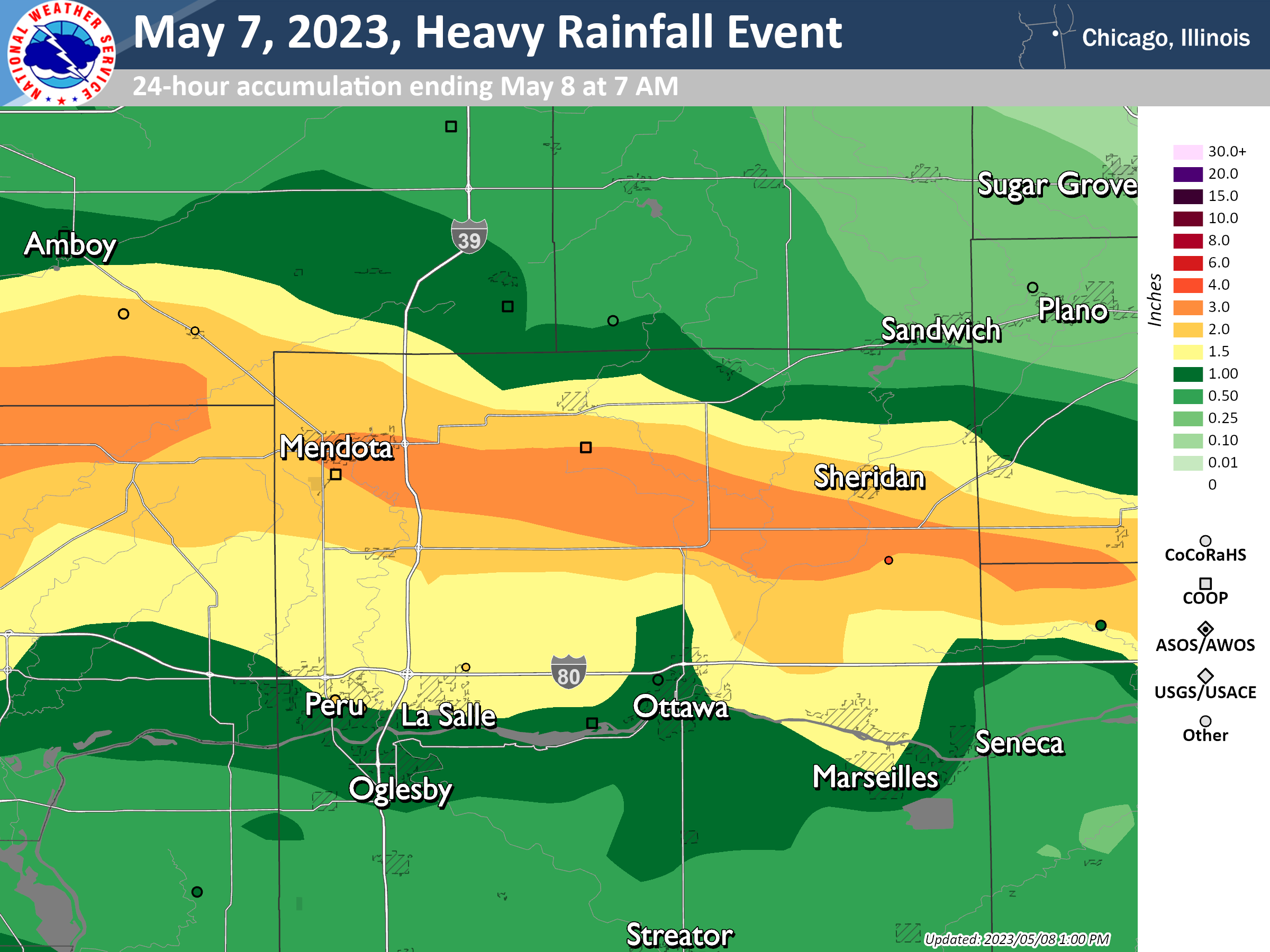
Rain Totals
 |
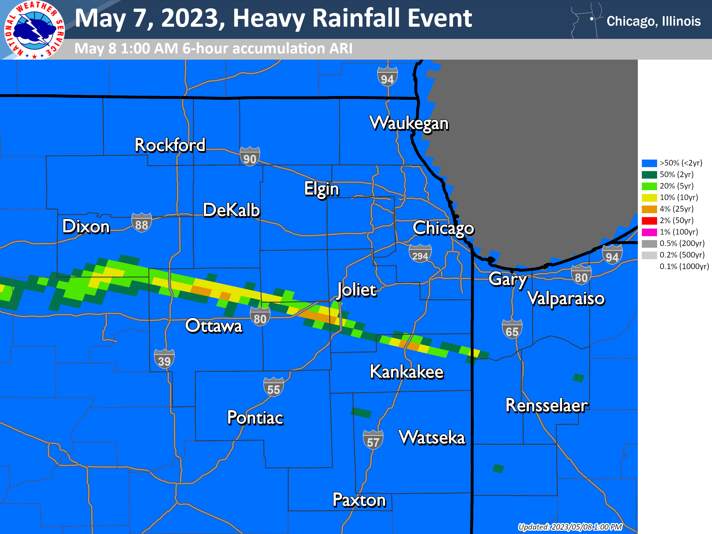 |
| Radar-estimated rainfall totals between 7 AM CDT on May 7 and 7 AM CDT on May 8 | Radar-estimated Average Recurrence Interval (ARI) during the period of heaviest rainfall (7 PM to 1 AM). |
 |
 |
| Zoomed-in view of 24-hour radar-estimated rainfall totals | Zoomed-in view of 24-hour radar-estimated rainfall totals |
        PUBLIC INFORMATION STATEMENT
        NATIONAL WEATHER SERVICE CHICAGO IL
        1148 AM CDT MON MAY 8 2023

        ...OBSERVED RAINFALL ACCUMULATIONS FOR 5/7/2023-5/8/2023...

        BELOW IS A LISTING OF HEAVY RAINFALL REPORTS FROM NORTHERN ILLINOIS
        AND NORTHWEST INDIANA FROM THE AFTERNOON OF SUNDAY, MAY 7TH THROUGH
        THE MORNING OF MONDAY, MAY 8TH AS RELAYED TO THE NATIONAL WEATHER
        SERVICE FROM A VARIETY OF SOURCES.


        ...PRECIPITATION REPORTS...

        LOCATION                     AMOUNT    TIME/DATE       PROVIDER

        ...ILLINOIS...

        ...GRUNDY COUNTY...
        CHANNAHON 4 SSW              4.72 IN   1134 PM 05/07   PUBLIC
        COAL CITY 4 NNW              2.80 IN   0700 AM 05/08   UCOOP
        MORRIS AIRPORT               2.62 IN   0655 AM 05/08   AWOS
        MORRIS 5 NNW                 2.60 IN   0530 AM 05/08   COCORAHS
        CARBON HILL 3 N              2.35 IN   0920 PM 05/07   COOP
        CARBON HILL 3 NNW            2.22 IN   0700 AM 05/08   COCORAHS
        CARBON HILL 3 NE             2.10 IN   0700 AM 05/08   COCORAHS
        MORRIS 1 NW                  1.45 IN   0800 AM 05/08   COOP
        MINOOKA                      1.04 IN   0800 AM 05/08   COCORAHS
        MORRIS 5 NW                  1.02 IN   0800 AM 05/08   COCORAHS

        ...IROQUOIS COUNTY...
        CRESCENT CITY 2 N            2.19 IN   0600 AM 05/08   COCORAHS
        WATSEKA                      1.77 IN   1100 AM 05/08   CWOP
        ASHKUM 6 E                   1.22 IN   0500 AM 05/08   COCORAHS

        ...KANKAKEE COUNTY...
        MANTENO 1 SSW                3.68 IN   1144 PM 05/07   PUBLIC
        GRANT PARK                   3.66 IN   1100 AM 05/08   CWOP
        MOMENCE 3 NNE                3.46 IN   0930 PM 05/07   PUBLIC
        ST. ANNE                     1.44 IN   0700 AM 05/08   COOP
        ST. ANNE 3 NNE               1.35 IN   0700 AM 05/08   COCORAHS
        AROMA PARK 1 S               1.12 IN   0700 AM 05/08   COCORAHS

        ...LA SALLE COUNTY...
        NORWAY                       4.84 IN   1113 PM 05/07   PUBLIC
        EARLVILLE 3 S                3.52 IN   0600 AM 05/08   COOP
        MENDOTA                      3.20 IN   0700 AM 05/08   COCORAHS
        MENDOTA 1 S                  2.94 IN   0700 AM 05/08   COOP
        DAYTON 1 WSW                 2.39 IN   1019 AM 05/08   PUBLIC
        PERU 1 NNE                   2.35 IN   0700 AM 05/08   COCORAHS
        UTICA                        2.29 IN   1045 AM 05/08   CWOP
        TROY GROVE 4 ESE             2.11 IN   0800 AM 05/08   COCORAHS
        LA SALLE                     2.04 IN   0700 AM 05/08   COCORAHS
        MARSEILLES 2 WSW             1.59 IN   0915 AM 05/08   COCORAHS
        OTTAWA                       1.42 IN   0920 AM 05/08   COCORAHS
        OTTAWA                       1.29 IN   0654 AM 05/08   COCORAHS
        OTTAWA - BUFFALO ROCK SP     1.14 IN   0727 AM 05/08   COOP
        STREATOR                     1.03 IN   1100 AM 05/08   CWOP

        ...LEE COUNTY...
        SUBLETTE                     2.39 IN   1058 AM 05/08   CWOP
        SUBLETTE 3 WNW               2.23 IN   0700 AM 05/08   COCORAHS
        AMBOY 1 WSW                  1.22 IN   0614 AM 05/08   COCORAHS
        PAW PAW 2 S                  1.18 IN   0700 AM 05/08   COOP
        NELSON 3 NNW                 1.03 IN   0800 AM 05/08   COCORAHS

        ...LIVINGSTON COUNTY...
        EMINGTON 2 SSE               1.91 IN   0600 AM 05/08   COCORAHS
        DWIGHT 2 SSE                 1.28 IN   0700 AM 05/08   COCORAHS
        FAIRBURY                     1.15 IN   0700 AM 05/08   COOP

        ...OGLE COUNTY...
        MOUNT MORRIS                 1.08 IN   1045 AM 05/08   CWOP
        POLO                         1.00 IN   0855 AM 05/08   PUBLIC

        ...WILL COUNTY...
        CHANNAHON 2 SSW              3.76 IN   0934 PM 05/07   PUBLIC
        CHANNAHON 5 S                3.60 IN   0700 AM 05/08   COCORAHS
        WILMINGTON - KANKAKEE R.     3.23 IN   0900 AM 05/08   HADS
        CHANNAHON 3 SE               2.43 IN   0700 AM 05/08   COCORAHS
        WILMINGTON                   2.14 IN   0700 AM 05/08   COCORAHS
        MIDEWIN RAWS                 2.14 IN   1005 AM 05/08   RAWS
        BONFIELD 6 NNE               1.61 IN   1100 AM 05/08   AWS
        LAKEWOOD SHORES 1 SE         1.14 IN   0630 AM 05/08   COCORAHS


        ...INDIANA...

        ...NEWTON COUNTY...
        MOROCCO                      2.47 IN   0600 AM 05/08   COOP
        KENTLAND 2 SSE               1.63 IN   0700 AM 05/08   COCORAHS

        OBSERVATIONS ARE COLLECTED FROM A VARIETY OF SOURCES WITH VARYING
        EQUIPMENT AND EXPOSURES. WE THANK ALL VOLUNTEER WEATHER OBSERVERS
        FOR THEIR DEDICATION. NOT ALL DATA LISTED ARE CONSIDERED OFFICIAL.
|
 |
Media use of NWS Web News Stories is encouraged! Please acknowledge the NWS as the source of any news information accessed from this site. Additional recaps can be found on the NWS Chicago Past Events Page |
|


.png)