Overview
|
An intense storm system pivoting northeastward through the lower Mississippi Valley on the evening of April 12th sparked a severe weather outbreak throughout the southeastern states on April 12th and 13th. As this storm system lifted through the Tennessee and Ohio Valleys on April 13th, an associated frontal boundary moved slowly through our region, resulting in widespread heavy rainfall and several rounds of strong to severe thunderstorms on April 14th and 15th. |
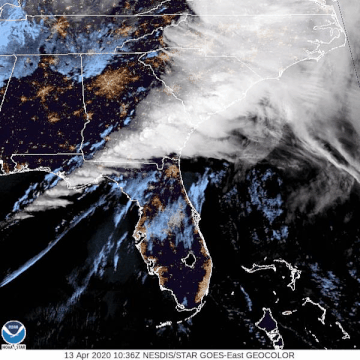 Geocolor visible satellite imagery from April 13, 2020. |
 |
 |
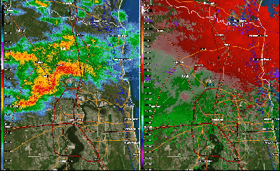 |
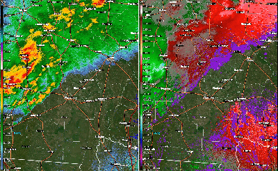
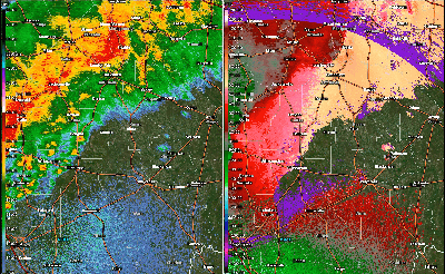
| Loop of KJAX reflectivity and velocity data from Odum, GA EF-1 tornado. | Loop of KVAX reflectivity and velocity data from Ambrose, GA EF-0 tornado. | Loop of KJAX reflectivity and velocity data from Duval-Nassau County, FL EF-0 tornado. |
Tornadoes:
|
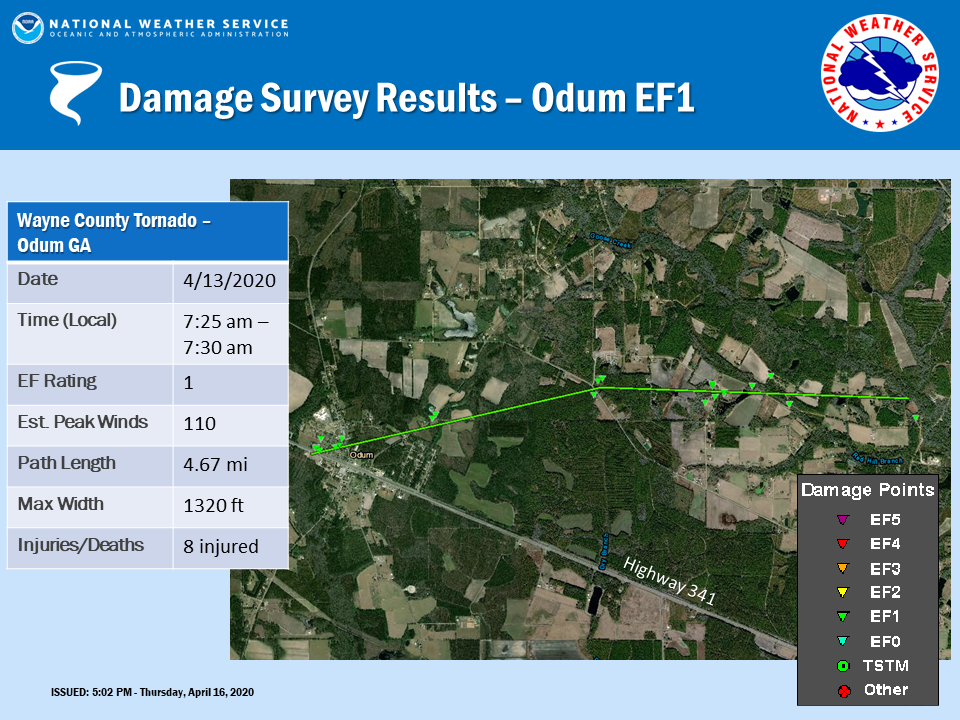
Tornado #1 - Odum, GA
|
||||||||||||||||
|
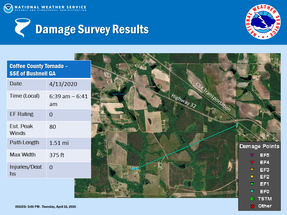
Tornado #2 - Ambrose, GA
|
||||||||||||||||
|
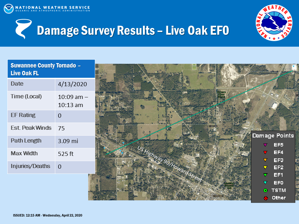
Tornado #3 - Live Oak, FL
|
||||||||||||||||
|
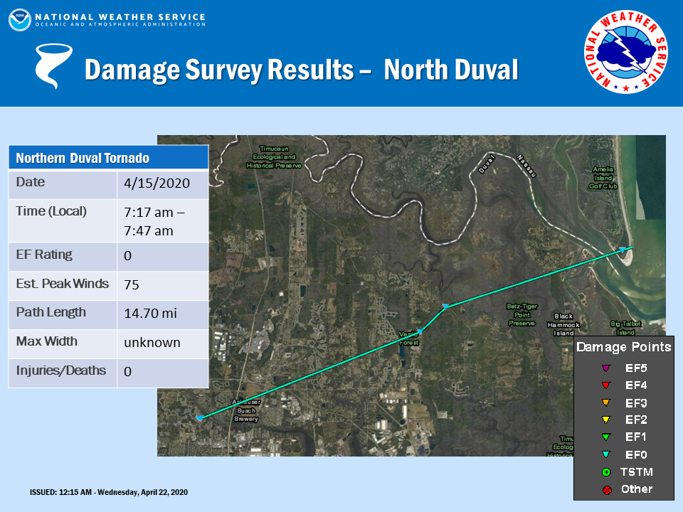
Tornado #4 - North Duval County, FL
|
||||||||||||||||
The Enhanced Fujita (EF) Scale classifies tornadoes into the following categories:
| EF0 Weak 65-85 mph |
EF1 Moderate 86-110 mph |
EF2 Significant 111-135 mph |
EF3 Severe 136-165 mph |
EF4 Extreme 166-200 mph |
EF5 Catastrophic 200+ mph |
 |
|||||
Photos & Video
Collection of Tweets from April 13, 2020
April 13, 2020 Svr Wx - Curated tweets by NWSJacksonvilleCollection of Tweets from April 15, 2020
April 15, 2020 Svr Wx - Curated tweets by NWSJacksonvilleStorm Reports
PRELIMINARY LOCAL STORM REPORT...SUMMARY
National Weather Service Jacksonville FL

..TIME...   ...EVENT...      ...CITY LOCATION...     ...LAT.LON...
..DATE...   ....MAG....      ..COUNTY LOCATION..ST.. ...SOURCE....
            ..REMARKS..

0624 AM     TSTM WND DMG     5 WNW DOUGLAS           31.54N 82.93W
04/13/2020                   Coffee             GA   EMERGENCY MNGR

            EMERGENCY MANAGER REPORTS WIND DAMAGE TO A VACATE MOBILE
            HOME NEAR CHANEY ROAD AND HIGHWAY 32. TIME ESTIMATED
            BASED ON RADAR.

0627 AM     TSTM WND DMG     5 WNW DOUGLAS           31.54N 82.92W
04/13/2020                   Coffee             GA   EMERGENCY MNGR

            NUMEROUS TREES AND POWER LINES WERE KNOCKED DOWN
            THROUGHOUT COFFEE COUNTY PER EMA AND 911.

0632 AM     TSTM WND DMG     7 S DOUGLAS             31.41N 82.85W
04/13/2020                   Coffee             GA   PUBLIC

            NEAR COFFEE COUNTY / AND ATKINSON COUNTY ALONG U.S.221
            NUMEROUS TREES, POWER LINES AND A POTENTIAL HOUSE ROOF
            WERE REPORTED BLOWN OFF.

0632 AM     TSTM WND DMG     2 E DOUGLAS             31.51N 82.82W
04/13/2020                   Coffee             GA   EMERGENCY MNGR

            TREES AND POWER LINES DOWN ACROSS COFFEE COUNTY. ROOF ON
            HOME COLLAPSED ON SLEEPY HALLOW FARM ROAD.

0639 AM     TORNADO          5 SE AMBROSE            31.55N 82.96W
04/13/2020                   COFFEE             GA   NWS STORM SURVEY

            IN THE EARLY MORNING HOURS OF APRIL 13TH, AN
            EF-O TORNADO WITH MAX WINDS OF 80 MPH
            TOUCHED DOWN ABOUT 5 MILES SE OF AMBROSE,
            GA. THE TORNADO WAS APPROXIMATELY 125 YARDS
            WIDE AND TRAVELED ABOUT 1.5 MILES BEFORE
            LIFTING NEAR HWY 32.

0640 AM     TSTM WND GST     DOUGLAS                 31.51N 82.85W
04/13/2020  M55.00 MPH       COFFEE             GA   ASOS

            DOUGLASS MUNICIPAL AIRPORT REPORTED A THUNDERSTORM WIND
            GUST OF 55 MPH AT 640 AM ET.

0640 AM     TSTM WND DMG     5 SE AMBROSE            31.54N 82.96W
04/13/2020                   Coffee             GA   EMERGENCY MNGR

            COFFEE COUNTY EMERGENCY MANAGEMENT SHARED PICTURES OF
            SIGNFICANT DAMAGE TO MOBILE HOMES AND AN EIGHTEEN WHEEL
            TRUCK OVERTURNED IN THE VICINTIY OF BUSHNELL.

0654 AM     TSTM WND GST     ALMA                    31.54N 82.48W
04/13/2020  M49.00 MPH       BACON              GA   ASOS

            ALMA ASOS MEASURED A PEAK GUST TO 49 MPH.

0710 AM     TSTM WND DMG     10 N PATTERSON          31.52N 82.15W
04/13/2020                   Appling            GA   EMERGENCY MNGR

            APPLING COUNTY EMERGENCY MANAGEMENT REPORTS TREES DOWNED
            ALONG STATE ROAD 203 AT THE WAYNE COUNTY LINE, A BUILDING
            DAMAGED ALONG LAKE GRIFFIS ROAD, AND TREES DOWNED ALONG
            LAKE CHAPEL ROAD NEAR THE INTERSECTION WITH DASHER ROAD.


0725 AM     TORNADO          WNW ODUM                31.67N 82.03W
04/13/2020                   Wayne              GA   EMERGENCY MNGR

            WAYNE COUNTY EMERGENCY MANAGEMENT SHARED PHOTOS OF A
            HOUSE RAISED ON CINDER BLOCK FOUNDATION THAT WAS SPUN OFF
            THE FOUNDATION IN ODUM. MAGNITUDE OF TORNADO WILL BE
            DETERMINED BY STORM SURVEY.

0725 AM     TSTM WND DMG     ODUM                    31.67N 82.03W
04/13/2020                   WAYNE              GA   LAW ENFORCEMENT

            WAYNE COUNTY SHERIFFS OFFICE REPORTS MULTIPLE HOUSES
            DAMAGED IN THE VICINITY OF ODUM.

0725 AM     TSTM WND DMG     2 ENE ODUM              31.67N 82.00W
04/13/2020                   Wayne              GA   PUBLIC

            *** 8 INJ *** ROOF AND WINDOW DAMAGE TO APPROXIMATELY 35
            HOMES IN THE VICINITY OF ODUM,WITH POWER LINES AND TREES
            KNOCKED DOWN ALONG WALTER GRIFFIS ROAD, HIRES AVENUE,
            HYMA POPPELL LOOP AND TANK ROAD. 8 INJURIES REPORTED WITH
            3 OF THOSE REQUIRING TRANSPORT TO THE HOSPITAL.

0725 AM     TORNADO          ODUM                    31.67N 82.03W
04/13/2020                   WAYNE              GA   NWS STORM SURVEY

            *** 8 INJ ***
            NWS STORM SURVEY FOUND EVIDENCE OF A
            HIGH-END EF-1 TORNADO WITH PEAK WINDS OF 110
            MPH TOUCHED DOWN IN THE CITY OF ODUM, GA AND
            TRAVELED EAST-NORTHEASTWARD FOR 4.67 MILES
            BEFORE LIFTING UP. THE PATH WIDTH WAS
            APPROXIMATELY 1/4 MILES AT ITS WIDEST.

0727 AM     TORNADO          2 ENE ODUM              31.68N 81.99W
04/13/2020                   Wayne              GA   EMERGENCY MNGR

            A TORNADO LIFTED A MANUFACTURED HOME OFF THE GROUND AND
            OVERTOP OF POWERLINES, WHERE IT THEN CRASHED TO THE
            GROUND IN A FIELD ADJACENT TO HYMA POPPELL LOOP NEAR
            POPPELL FARMS TO THE NORTHEAST OF ODOM. THE INTENSITY OF
            THIS TORNADO WILL BE DETERMINED BY A STORM SURVEY THAT
            WILL BE CONDUCTED THIS AFTERNOON. TIME OF DAMAGE BASED ON
            RADAR DATA.

0738 AM     TSTM WND GST     JESUP                   31.60N 81.89W
04/13/2020  M41.00 MPH       Wayne              GA   AWOS

            JESUP GEORGIA AWOS STATION KJES MEASURED A GUST TO 41
            MPH.

0740 AM     TSTM WND DMG     3 WNW DOCTORTOWN        31.67N 81.88W
04/13/2020                   WAYNE              GA   TRAINED SPOTTER

            SNAPPED TREES, DAMAGE TO PORCH ROOF AND
            TOTALED GREENHOUSE. NEIGHBOR SINGLE-WIDE
            TRAILER BLOWN OFF FOUNDATION.

0910 AM     TSTM WND GST     11 NNW STEPHEN FOSTER S 30.98N 82.40W
04/13/2020  M41.00 MPH       Charlton           GA   MESONET

            THE REMOTE AUTOMATIC WEATHER STATION IN THE NORTHWESTERN
            PORTION OF THE OKEFENOKEE SWAMP MEASURED A PEAK WIND GUST
            OF 41 MPH.

0940 AM     TSTM WND DMG     5 WNW KINGSLAND         30.81N 81.75W
04/13/2020                   Camden             GA   DEPT OF HIGHWAYS

            THE CITY OF KINGSLAND POSTED INFORMATION ON SOCIAL MEDIA
            REGARDING A TREE DOWNED BY STRONG WIND GUSTS NEAR THE
            INTERSECTION OF GEORGIA HIGHWAY 40 AND COLERAIN ROAD.
            TIME OF DAMAGE BASED ON RADAR DATA.

1009 AM     TORNADO          1 WNW LIVE OAK          30.30N 83.01W
04/13/2020                   Suwannee           FL   EMERGENCY MNGR

            AN EF-0 TORNADO TOUCHED DOWN JUST NORTHEAST OF THE
            SUWANNEE COUNTY AIRPORT AND MOVED EAST-NORTHASTWARD
            ACROSS U.S. HIGHWAY 90, DAMAGING THREE BUILDINGS ADJACENT
            TO GOLDKIST BOULEVARD, INCLUDING PARTIALLY PEELING THE
            ROOF OFF OF THE FARMERS COOPERATIVE BUILDING. THE TORNADO
            CONTINUED EAST-NORTHEASTWARD WITH SPORADIC DAMAGE NEAR
            NOBLES FERRY ROAD AND HOUSTON AVENUE AND THEN LIFTED NEAR
            THE WALMART SUPERCENTER ADJACENT TO U.S. HIGHWAY 129.

1009 AM     TORNADO          2 NW LIVE OAK           30.31N 83.01W
04/13/2020                   SUWANNEE           FL   NWS STORM SURVEY

            ON THE MORNING OF APRIL 13TH, AN EF-O
            TORNADO WITH MAX WINDS OF 75 MPH TOUCHED
            DOWN ON THE NW SIDE OF LIVE OAK, GA NEAR THE
            FARMERS COOP. THE TORNADO WAS APPROXIMATELY
            175 YARDS WIDE AND TRAVELED A SPOTTY 3 MILE
            PATH (LIFTING UP AND TOUCHING BACK DOWN
            AGAIN A FEW TIMES) BEFORE FINALLY LIFTING ON
            THE NE SIDE OF TOWN, JUST SOUTH OF THE
            WALMART.

1010 AM     TSTM WND DMG     2 WNW LIVE OAK          30.31N 83.01W
04/13/2020                   Suwannee           FL   EMERGENCY MNGR

            SUWANNEE COUNTY EMERGENCY MANAGEMENT REPORTS THREE
            DAMAGED ALONG U.S. HIGHWAY 90 JUST WEST OF DOWNTOWN LIVE
            OAK ALONG GOLDKIST BOULEVARD. THE ROOF OF THE FARMERS
            COOPERATIVE BUILDING WAS AT LEAST PARTIALLY TORN OFF.
            TIME OF DAMAGE BASED ON RADAR DATA.

1010 AM     HEAVY RAIN       5 ESE NAHUNTA           31.17N 81.90W
04/13/2020  M2.43 INCH       Brantley           GA   PUBLIC

            FORMER NWS EMPLOYEE REPORTED 2.43 INCHES OF RAINFALL IN
            ABOUT 100 MINUTES ABOUT 6 MILES TO THE SOUTHEAST OF
            NAHUNTA.

1016 AM     TSTM WND DMG     LIVE OAK                30.29N 82.99W
04/13/2020                   SUWANNEE           FL   911 CALL CENTER

            WIDESPREAD REPORTS OF TREES AND POWERLINES REPORTED
            ACROSS SUWANNEE COUNTY, FLORIDA.

0845 AM     TSTM WND DMG     10 SW LIVE OAK          30.19N 83.10W
04/14/2020                   Suwannee           FL   911 CALL CENTER

            SUWANNEE COUNTY 911/DISPATCH REPORTED TREES AND
            POWERLINES DOWN ALONG 144TH STREET NEAR LURAVILLE. TIME
            OF DAMAGE BASED ON RADAR DATA.

0850 AM     TSTM WND DMG     4 NNW LURAVILLE         30.17N 83.20W
04/14/2020                   Suwannee           FL   EMERGENCY MNGR

            SUWANNEE COUNTY EMERGENCY MANAGEMENT RELAYED PHOTOS OF
            PLAYGROUND EQUIPMENT AND A METAL SHED DAMAGED BY
            SUB-SEVERE WIND GUSTS. TIME OF DAMAGE BASED ON RADAR
            DATA.

1007 AM     TSTM WND GST     MAYPORT                 30.38N 81.42W
04/14/2020  M43 MPH          DUVAL              FL   AWOS

            AWOS STATION KNRB MAYPORT NAVAL STATION.

1010 AM     TSTM WND GST     2 N MAYPORT             30.42N 81.41W
04/14/2020  M41 MPH          AMZ452             FL   MESONET

            MESONET STATION XHUP HUGUENOT PARK.

1255 PM     TSTM WND DMG     1 ESE MANNVILLE         29.62N 81.85W
04/14/2020                   PUTNAM             FL   911 CALL CENTER

            TREE DOWN ON POWER LINE NEAR INTERLACHEN.

0258 AM     TSTM WND DMG     4 NNE COLUMBIA          30.13N 82.66W
04/15/2020                   COLUMBIA           FL   EMERGENCY MNGR

            SNAPPED TREE FELL ON MOBILE HOME AND SHED
            CAUSING ROOFS TO CAVE IN. RADAR ESTIMATED
            TIME.

0717 AM     TORNADO          4 SSE JACKSONVILLE INTE 30.44N 81.67W
04/15/2020                   Duval              FL   NWS STORM SURVEY

            DURING THE EARLY MORNING HOURS ON APRIL 15TH, AN EF-0
            TORNADO TOUCHED DOWN IN THE BISCAYNE DOWNS SUBDIVISION
            NEAR THE BROWARD RIVER JUST EAST OF INTERSTATE 95,
            DESTROYING A SUNROOM AND KNOCKING DOWN TREES ALONG
            SARASOTA LANE, RIVA RIDGE DRIVE AND SECRETARIAT DRIVE
            NORTH. THE TORNADO LIKELY LIFTED BEFORE CROSSING THE
            BROWARD RIVER, WITH SPORADIC DAMAGE THROUGH OCEANWAY
            BEFORE THE TORNADO CAUSED FURTHER TREE DAMAGE ALONG
            GROVER ROAD, BONEY ROAD AND STARRATT ROAD THROUGH BLACK
            HAMMOCK ISLAND.

0718 AM     TSTM WND DMG     3 SW OCEANWAY           30.44N 81.67W
04/15/2020                   DUVAL              FL   EMERGENCY MNGR

            MULTIPLE TREES DOWN NEAR SECRETARIAT LANE
            NORTH. RADAR ESTIMATED TIME.

0718 AM     TSTM WND DMG     3 SW OCEANWAY           30.44N 81.67W
04/15/2020                   DUVAL              FL   BROADCAST MEDIA

            SNAPPED TREE FELL ON HOUSE NEAR SARASOTA
            LANE. RADAR ESTIMATED TIME.

0736 AM     TSTM WND DMG     5 ENE OCEANWAY          30.50N 81.55W
04/15/2020                   DUVAL              FL   BROADCAST MEDIA

            UPROOTED TREES AND BROKEN TREE LIMBS ON
            PROPERTY NEAR GROVER ROAD AND STARATT ROAD.
            RADAR ESTIMATED TIME.

0738 AM     TSTM WND DMG     6 ENE OCEANWAY          30.50N 81.54W
04/15/2020                   DUVAL              FL   BROADCAST MEDIA

            SNAPPED TREE FELL ON A TRUCK AND UPROOTED
            TREES FELL ACROSS BONEY ROAD. RADAR
            ESTIMATED TIME.

0746 AM     WATER SPOUT      4 NNW TALBOT ISLAND     30.52N 81.45W
04/15/2020                   AMZ452             FL   BROADCAST MEDIA

            VIDEO OF WATER SPOUT NEAR THE A1A BRIDGE
            FROM BIG TALBOT ISLAND TO AMELIA ISLAND.
            RADAR ESTIMATED TIME.


&&

$$
Environment
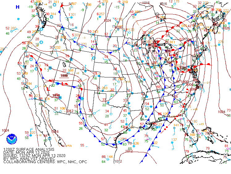
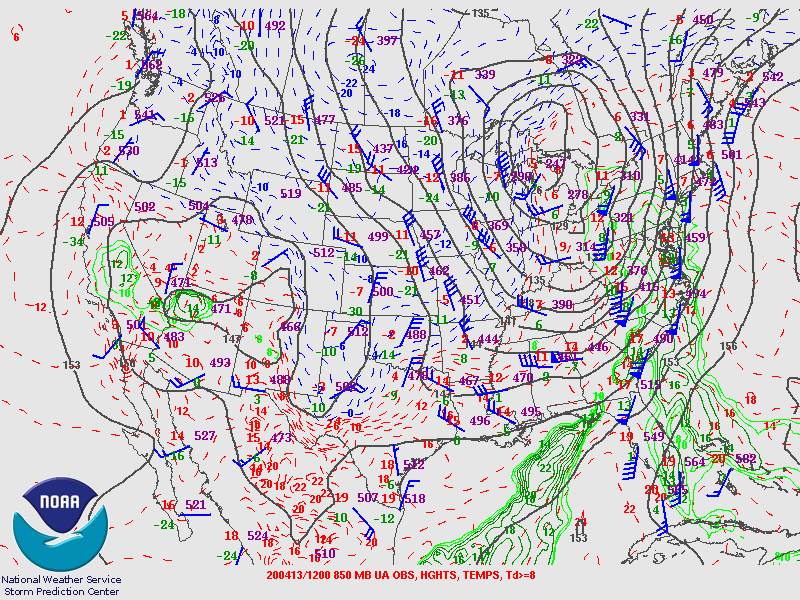
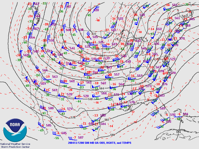
A potent shortwave trough was aloft of the southeast, enhancing divergence aloft as a strong cold front approached southeast Georgia and northeast Florida in the morning hours of April 13th. This piece of energy would lift northeastward, swinging off the mid-Atlantic coast later that day, causing the front to stall out over the area. The stalled frontal boundary would waver back and forth April 14th-15th. The jets at 500 mb and 300 mb both featured 90 kt winds aloft of JAX and even at 850 mb, winds were 65 kts.
 |
 |
 |
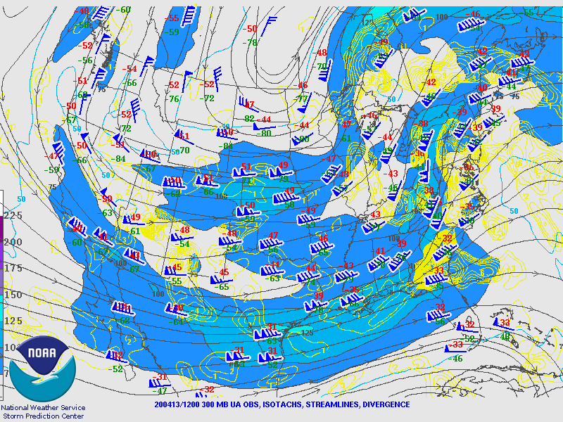 |
| 4/13 12Z Surface Analysis | 4/13 12Z 850 mb Analysis | 4/13 12Z 500 mb Analysis | 4/13 12Z 300 mb Analysis |
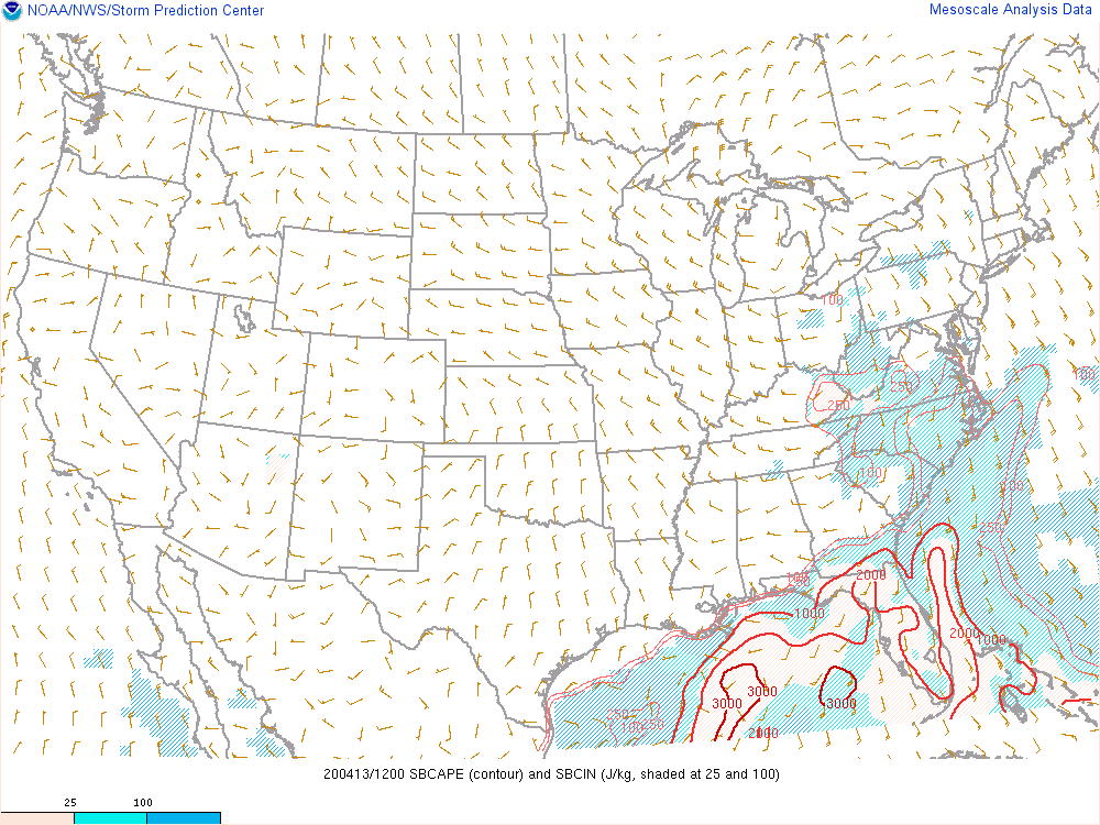
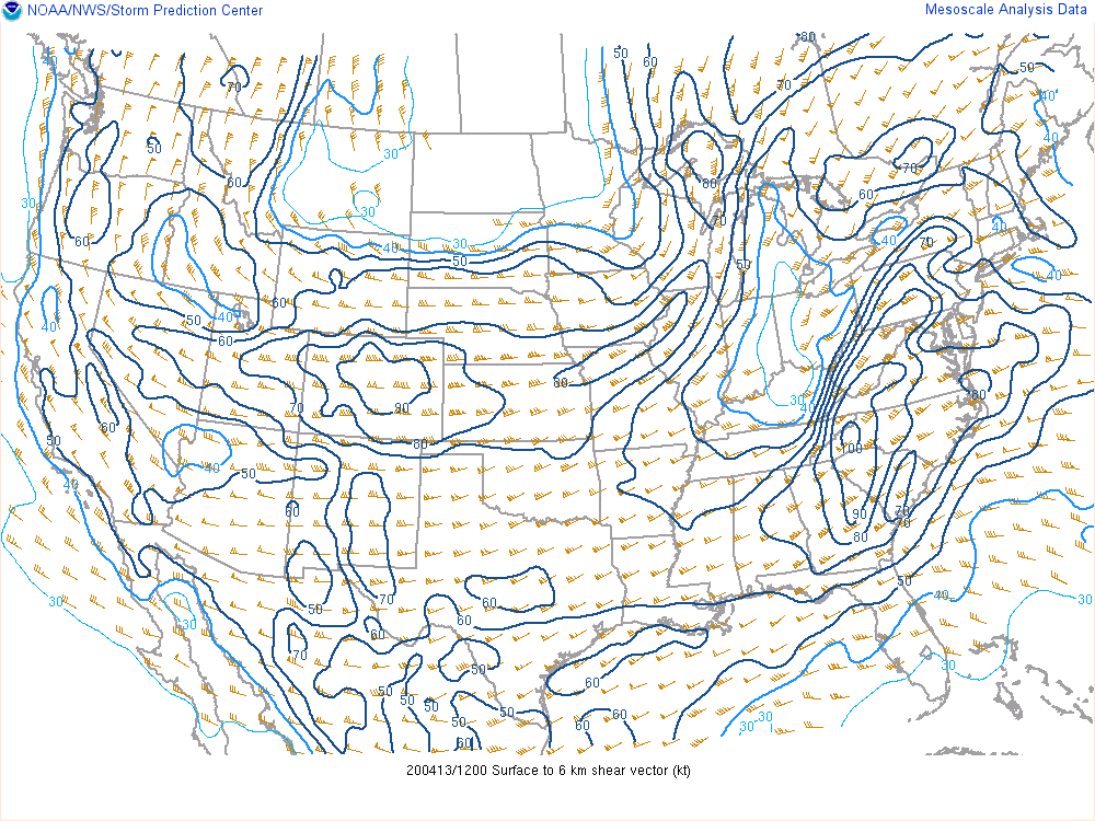
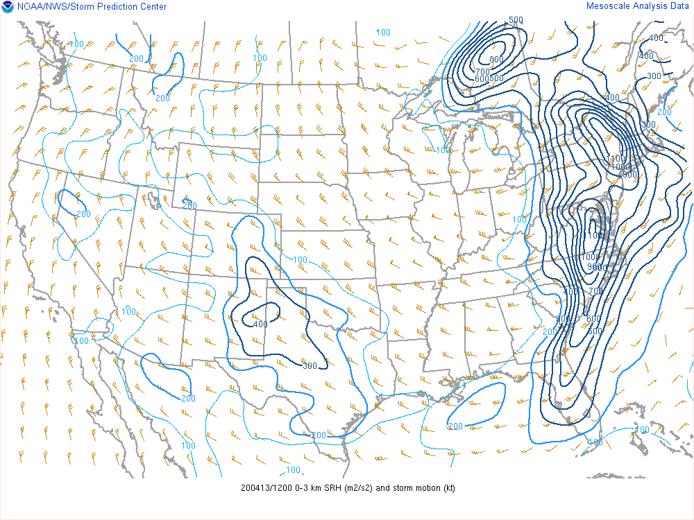
Instability and shear were both available to be tapped into the morning of April 13th. 12Z RAP analysis showed 1000-2000 J/kg SBCAPE across southeast Georgia and northeast Florida, with over 2000 J/kg SBCAPE over the lower Suwannee Valley. Deep layer shear may have peaked over the Tennessee Valley at 90-100 kts, but there was still plenty available across our local area- about 50-60 kts across northeast Florida, 60-70 kts across southeast Georgia. Similarly, 12Z RAP analysis sowed low level (0-3 km) SRH peaked to our north across the mid-Atlantic at a whopping 1000 m2/s2, but 300-500 m2/s2 SRH was available locally. At KJAX, the 12Z sounding actually showed 546 m2/s2 0-1 km SRH and 771 m2/s2 0-3 km SRH with about 1300 J/kg SBCAPE and 63 kts effective shear. The Significant Tornado Parameter for the effective layer was 5.1, showing the environment was very favorable for not only the development of tornadoes, but of significant tornadoes (EF2 or greater).
 |
 |
 |
 |
| 4/13 12Z Surface Based CAPE | 4/13 12Z 0-6 km Shear | 4/13 12Z 0-3 km SRH | 4/13 12Z KJAX Sounding |
 |
Media use of NWS Web News Stories is encouraged! Please acknowledge the NWS as the source of any news information accessed from this site. |
|