Overview
|
A squall line ahead of a strong cold front moved across southeast Georgia and northeast Florida in the afternoon and evening hours of Christmas Eve. This squall line produced 3 EF1 tornadoes in the areas of Starke, FL, Fruit Cove, FL, and Jacksonville, FL in addition to widespread wind damage from gusts in both SE GA and NE FL. |
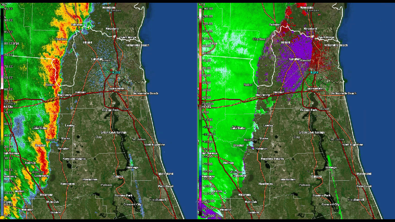 Squall Line Animation (Base Reflectivity and Velocity Data from KJAX Dec 24th) |
Tornadoes:
|
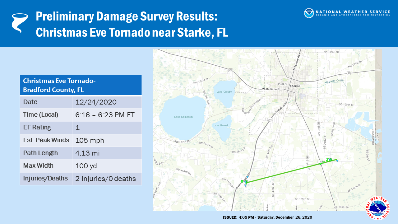
EF1 Tornado - Starke, FL
|
||||||||||||||||
|
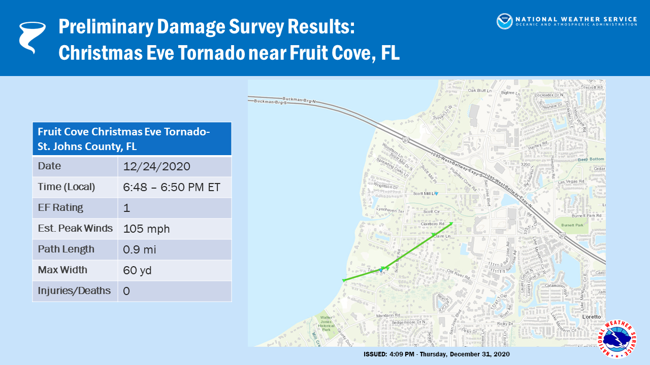
EF1 Tornado - Fruit Cove, FL
|
||||||||||||||||
|
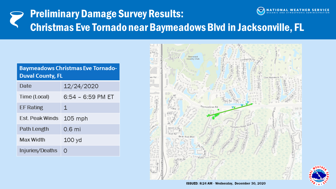
EF1 Tornado - Jacksonville, FL (Baymeadows)
|
||||||||||||||||
The Enhanced Fujita (EF) Scale classifies tornadoes into the following categories:
| EF0 Weak 65-85 mph |
EF1 Moderate 86-110 mph |
EF2 Significant 111-135 mph |
EF3 Severe 136-165 mph |
EF4 Extreme 166-200 mph |
EF5 Catastrophic 200+ mph |
 |
|||||
Photos & Video
Collection of Twitter Reports from the Christmas Eve Squall Line Event
Christmas Eve 2020 Squall - Curated tweets by NWSJacksonvilleStorm Reports
PRELIMINARY LOCAL STORM REPORT...SUMMARY
NATIONAL WEATHER SERVICE JACKSONVILLE FL
830 PM EST FRI DEC 25 2020

..TIME...   ...EVENT...      ...CITY LOCATION...     ...LAT.LON...
..DATE...   ....MAG....      ..COUNTY LOCATION..ST.. ...SOURCE....
            ..REMARKS..

1210 PM     NON-TSTM WND GST GAINESVILLE             29.67N 82.34W
12/24/2020  M41.00 MPH       ALACHUA            FL   MESONET

            ELEVATED MESONET OBSERVATION ON THE UNIVERSITY OF FLORIDA
            CAMPUS REPORTED WIND GUST TO 41 MPH FROM THE SOUTH.

1223 PM     NON-TSTM WND GST MAYPORT                 30.38N 81.41W
12/24/2020  M41.00 MPH       DUVAL              FL   ASOS

            MAYPORT NAVAL STATION ASOS MEASURED A WIND GUST OF 41 MPH
            FROM THE SOUTH.

0320 PM     NON-TSTM WND GST 2 SSW GAINESVILLE       29.65N 82.35W
12/24/2020  M42.00 MPH       ALACHUA            FL   MESONET

            THE WEATHERFLOW SENSOR AT UF ON THE STADIUM MEASURED A
            GRADIENT WIND GUST OF 42 MPH.

0527 PM     TSTM WND DMG     3 NNE WELLBORN          30.26N 82.80W
12/24/2020                   SUWANNEE           FL   BROADCAST MEDIA

            STRONG WINDS DROPPED A TREE ONTO A HOUSE RESULTING IN
            MAJOR DAMAGE. NO INJURIES REPORTED.

0530 PM     TSTM WND DMG     4 S BELL                29.70N 82.86W
12/24/2020                   GILCHRIST          FL   EMERGENCY MNGR

            NUMEROUS TREES REPORTED DOWN JUST SOUTH OF HIGHWAY 232.
            TIME ESTIMATED BY RADAR.

0545 PM     TSTM WND DMG     1 NNE JESUP             31.61N 81.88W
12/24/2020                   WAYNE              GA   911 CALL CENTER

            SEVERAL TREES REPORTED DOWN IN JESUP. TIME ESTIMATED BY
            RADAR.

0556 PM     TSTM WND DMG     LAKE BUTLER             30.02N 82.34W
12/24/2020                   UNION              FL   PUBLIC

            TREE BRANCH BREACHED WALL OF HOME DUE TO STRONG WINDS IN
            THE AREA OF LAKE BUTLER. NO INJURIES REPORTED.

0611 PM     TSTM WND GST     GAINESVILLE AIRPORT     29.69N 82.28W
12/24/2020  M55.00 MPH       ALACHUA            FL   ASOS

0635 PM     TSTM WND GST     KEYSTONE HEIGHTS        29.78N 82.03W
12/24/2020  M45.00 MPH       CLAY               FL   AWOS

            THE KEYSTONE HEIGHTS AIRPORT MEASURED A WIND GUST TO 45
            MPH.

0638 PM     TSTM WND GST     BRUNSWICK               31.14N 81.47W
12/24/2020  M59.00 MPH       GLYNN              GA   ASOS

            THE BRUNSWICK GLYCO AIRPORT ASOS MEASURED A WIND GUST TO
            59 MPH.

0651 PM     TSTM WND GST     1 NE JACKSONVILLE INTER 30.49N 81.70W
12/24/2020  M46.00 MPH       DUVAL              FL   ASOS

0654 PM     TSTM WND GST     5 NNW ARLINGTON         30.40N 81.63W
12/24/2020  M52.00 MPH       DUVAL              FL   C-MAN STATION

            NOAA PORTS STATION NFDF1 MEASURED A PEAK GUST TO 52 MPH.

0655 PM     TSTM WND DMG     6 ENE MANDARIN          30.18N 81.56W
12/24/2020                   DUVAL              FL   BROADCAST MEDIA

            TREE OF 3 TO 4 INCH DIAMETER KNOCKED DOWN NEAR SOUTHSIDE
            AND INTERSTATE 95.

0655 PM     TSTM WND DMG     3 S GREEN COVE SPRINGS  29.95N 81.68W
12/24/2020                   CLAY               FL   NWS EMPLOYEE

            POWER LINE DOWNED ACROSS ROAD SOUTH OF GREEN COVE
            SPRINGS.

0658 PM     TSTM WND GST     5 NNE ORANGE PARK       30.24N 81.68W
12/24/2020  M54.00 MPH       DUVAL              FL   AWOS

            A WIND GUST TO 54 MPH WAS MEASURED AT NAS JACKSONVILLE.

0700 PM     TSTM WND DMG     4 S UNF                 30.22N 81.52W
12/24/2020                   DUVAL              FL   BROADCAST MEDIA

            LIGHT POLE BLOWN KNOCKED DOWN IN WINN DIXIE PARKING IN
            BAYMEADOWS.

0703 PM     TSTM WND GST     5 E ARLINGTON           30.33N 81.52W
12/24/2020  M50.00 MPH       DUVAL              FL   ASOS

            CRAIG MUNICIPAL AIRPORT REPORTED A 50 MPH WIND GUST.

0709 PM     TSTM WND GST     2 N MAYPORT             30.42N 81.41W
12/24/2020  M64.00 MPH       AMZ452             FL   MESONET

            WEATHERFLOW SITE AT HUGUENOT PARK MEASURED PEAK GUST OF
            64 MPH/56 KNOTS FROM THE SOUTHWEST.

0715 PM     TSTM WND GST     FERNANDINA BEACH        30.66N 81.45W
12/24/2020  M47.00 MPH       NASSAU             FL   AWOS

            FERNANDINA BEACH AIRPORT AWOS MEASURED A GUST TO 47 MPH.

0720 PM     TSTM WND DMG     2 SSE STARKE            29.93N 82.10W
12/24/2020                   BRADFORD           FL   EMERGENCY MNGR

            *** 2 INJ *** SEVERE WEATHER DAMAGES REPORTED TO THREE
            HOMES IN THE STARKE AREA DUE TO A POSSIBLE TORNADO
            TOUCHDOWN. TWO OF THE HOME4S HAVE SUSTAINED MODERATE
            DAMAGE AND ONE WAS REPORTED WITH HEAVY DAMAGE. A TOTAL OF
            FOUR PEOPLE HAVE BEEN DISPLACED, TWO FROM THE HOME WITH
            HEAVT DAMAGE AND ONE FROM EACH HOME WITH MODERATE DAMAGE.
            TWO PEOPLE WERE TRANSPORTED TO THE HOSPITAL AS A
            PRECAUTION AND WERE LATER RELEASED.

0722 PM     TSTM WND GST     ELKTON                  29.78N 81.43W
12/24/2020  E50.00 MPH       ST. JOHNS          FL   TRAINED SPOTTER

            A SPOTTER NEAR ELKTON ESTIMATED WIND GUST OF 50 MPH.

0728 PM     TSTM WND GST     4 SE SAINT AUGUSTINE    29.86N 81.26W
12/24/2020  M49.00 MPH       AMZ454             FL   C-MAN STATION

            CMAN SAUF1 MEASURED A GUST TO 49 MPH/43 KNOTS FROM THE
            SOUTH-SOUTHWEST.

0745 PM     TSTM WND DMG     5 S MARINELAND          29.59N 81.23W
12/24/2020                   FLAGLER            FL   EMERGENCY MNGR

            TREE DOWN ON A POWER LINE ON FELLOWSHIP DRIVE. TIME
            ESTIMATED BY RADAR
Environment
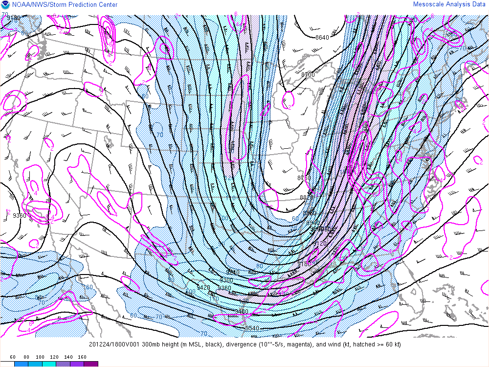
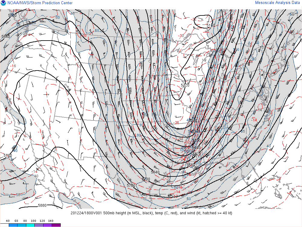
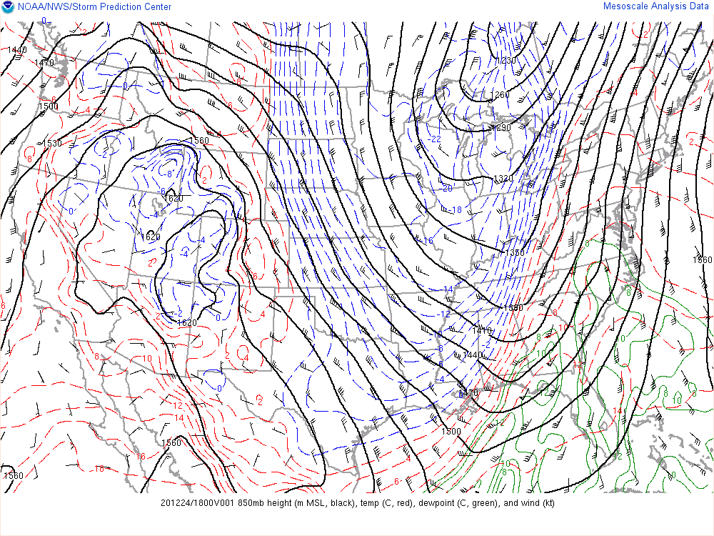
At 18Z (1 PM EST) on Christmas Eve 2020, a broad upper level trough was in place over the eastern CONUS, with the positively tilted trough axis stretching from the western Great Lakes down through the ArkLaTex. Strong upper level divergence was aloft of north Florida and south Georgia, enhancing vertical motion over the region. At 500 mb, the trough axis was ever so slightly further east, stretching from the central Great Lakes down to the lower Mississippi Valley. The 500mb jet featured 100-120 kt winds over Mississippi and western Alabama, with 80-100 kt winds aloft our our area of responsibility. At 850 mb, the large trough was even further east, stretching down the Ohio Valley and into the southeastern US, with a shortwave at the base of the axis enhancing low level pressure drops. Dew points over our area of responsibility were generally 8-10C, with strong south-southwesterly winds of 40-50 kts. At the surface, the nearest low pressure system was analyzed near the Alabama/Georgia border, with the corresponding cold front stretching south then southwest down the state line and over the Florida Panhandle. Surface winds were generally south-southeasterly around 20 kts over the local area.
 |
 |
 |
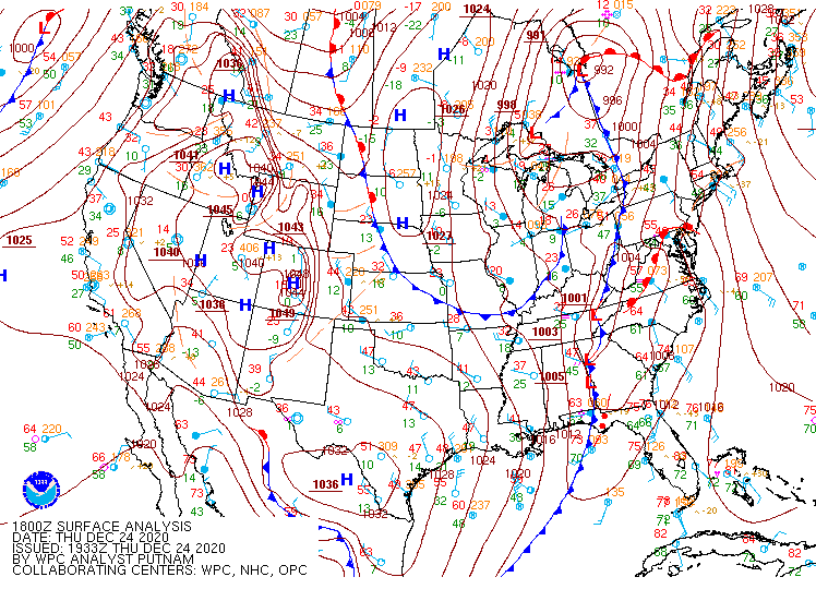 |
| 300 mb analysis from 18Z on 12/24/2020 | 500 mb analysis from 18Z on 12/24/2020 | 850 mb analysis from 18Z on 12/24/2020 | Surface analysis from 18Z on 12/24/2020 |
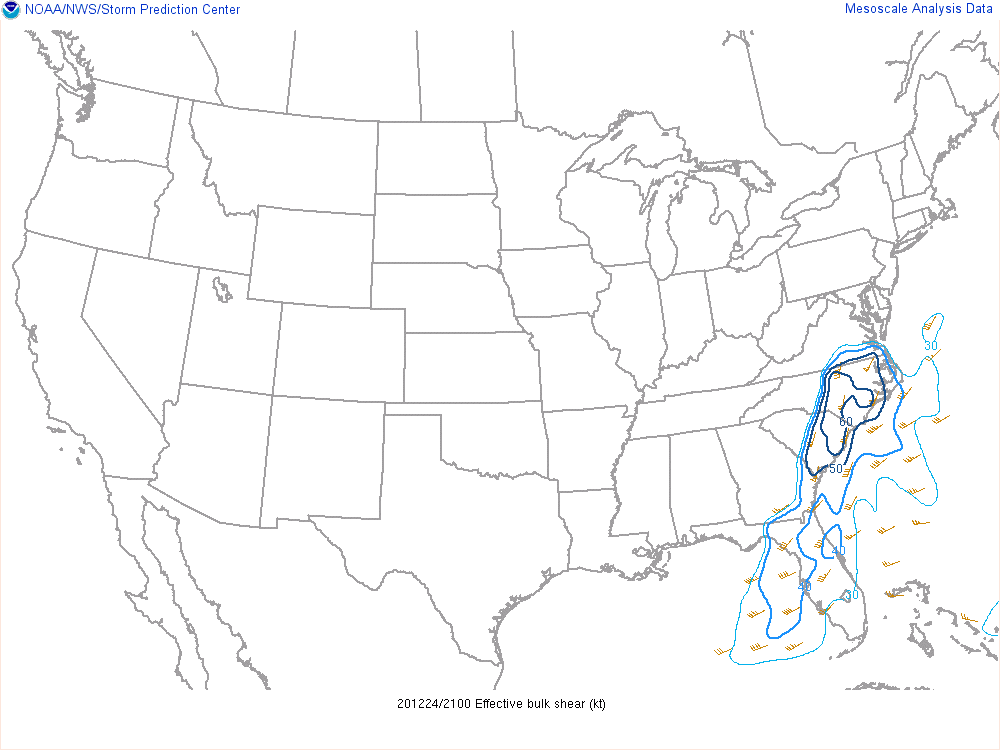
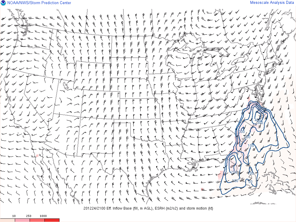
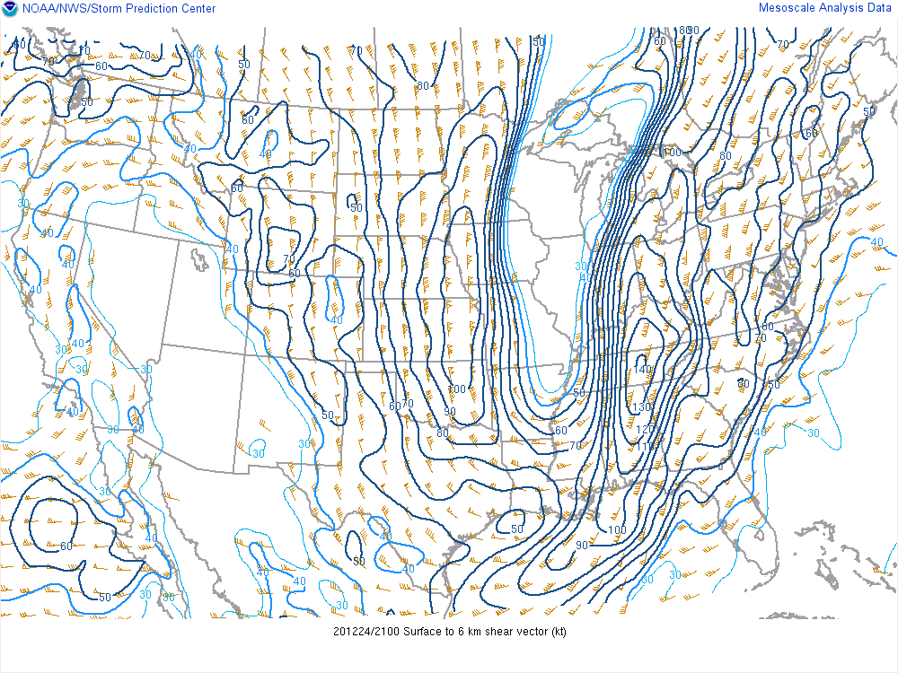
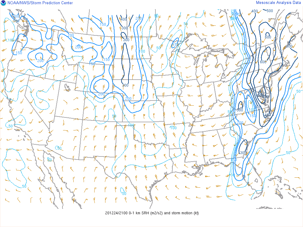
By 21Z (4 PM EST), the line of storms was beginning to move into our forecast area. Effective bulk shear along/ahead of the approaching line was around 40 kts, with effective storm-relative helicity values of around 200 m2/s2. While these values indicate potential for organized storms that could produce wind damage or tornadoes, the MLCAPE was relatively low, generally around 250 J/kg or less. Dialing down to more specific shear levels, the 0-6 km wind shear was from the southwest at 40-60 kts and the 0-1 km storm relative helicity was 150-300 m2/s2. If you had looked at the 12Z KJAX sounding from that morning, you might have noticed that even the forecast parcel had no CAPE at all, despite the high shear in place.
The environment in place was what we would consider a high-shear and low-CAPE environment. This type of environment can produce tornadoes and damaging straight-line winds, but it's a little less straight forward in terms of determining the main threats than other environments. One factor that made all the difference in this event was the orientation of the shear vectors relative to the storms as they evolved. In the case of the 3 tornadoes that developed, they formed along a bowing segment of the line which means that portion of the line had a more NW-SE orientation versus the N-S orientation of other sections of the line, making it more orthogonal to the shear vectors and therefore more favorable for the development of tornadoes.
 |
 |
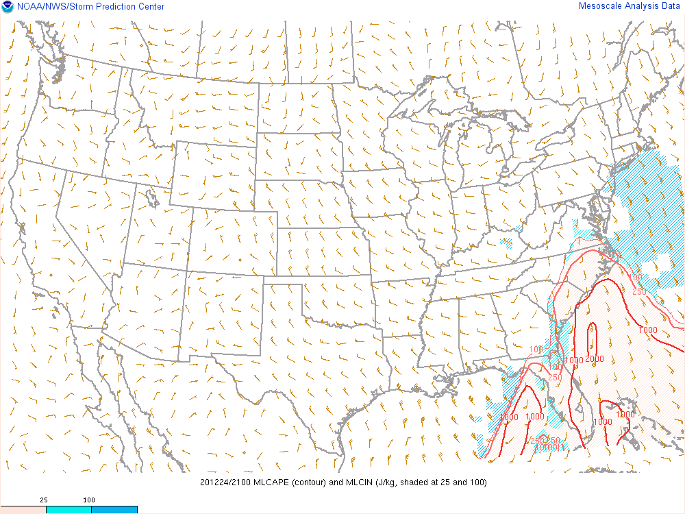 |
| Effective bulk shear at 21Z on 12/24/2020 | Effective storm relative helicity (SRH) at 21Z on 12/24/2020 | MLCAPE at 21Z on 12/24/2020 |
 |
 |
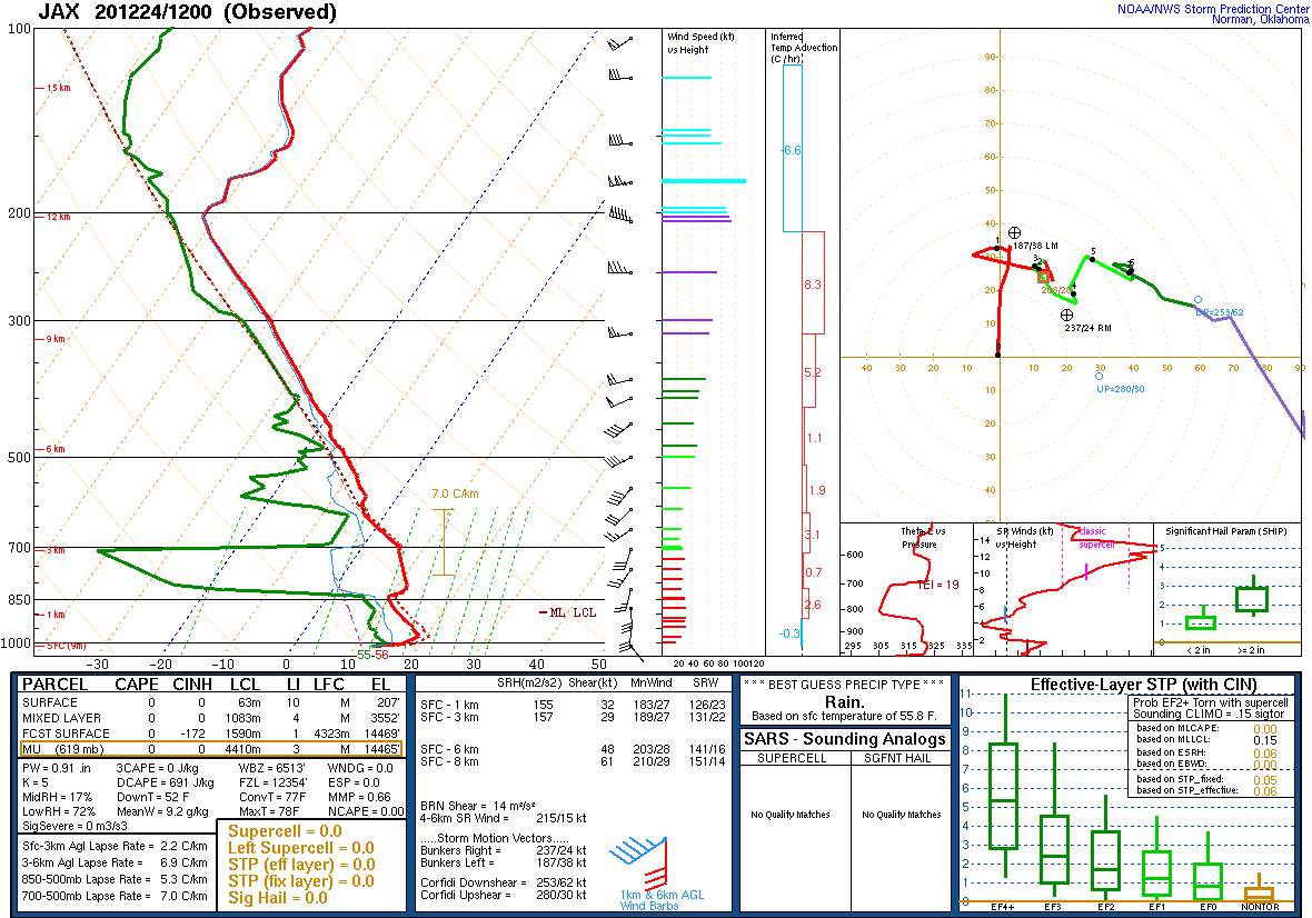 |
| 0-6 km shear at 21Z on 12/24/2020 | 0-1 km SRH at 21Z on 12/24/2020 | KJAX 12Z sounding on 12/24/2020 |
 |
Media use of NWS Web News Stories is encouraged! Please acknowledge the NWS as the source of any news information accessed from this site. |
|