Overview
|
An intense merger of thunderstorms occurred along the I-95 corridor over and near the Jacksonville metro area on the evening of August 10, 2020. These thunderstorms produced excessive lightning, gusty winds, and heavy downpours leading to flash flooding. A swath of rainfall ranging from 2 to 5 inches fell from the Florida/Georgia border to downtown Jacksonville to Fruit Cove in about a 2 hour time frame. The most intense flash flooding occurred in downtown Jacksonville in the Riverside, Avondale, Murray Hill, and Ortega areas. Numerous streets were flooded and multiple cars were stranded with potentially about one foot of water on the roads. |
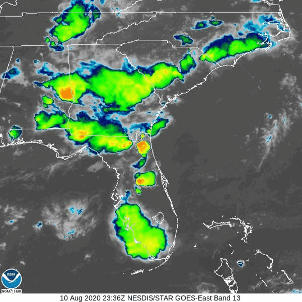 Loop of IR satellite imagery on August 10, 2020. |
Rain Reports
PUBLIC INFORMATION STATEMENT
NATIONAL WEATHER SERVICE JACKSONVILLE FL
1209 AM EDT TUE AUG 11 2020

...PRECIPITATION REPORTS...

LOCATION                     AMOUNT    TIME/DATE       LAT/LON
JACKSONVILLE                 5.94 IN   1204 AM 08/11   30.31N/81.69W
JACKSONVILLE                 3.52 IN   1046 PM 08/10   30.21N/81.60W
JACKSONVILLE INTL AIRPORT    3.50 IN   1156 PM 08/10   30.50N/81.68W
JACKSONVILLE                 3.21 IN   1202 AM 08/11   30.16N/81.63W
FRUIT COVE                   2.66 IN   1202 AM 08/11   30.11N/81.64W
SAINT JOHNS                  2.54 IN   1201 AM 08/11   30.12N/81.62W
SAINT JOHNS                  2.50 IN   1203 AM 08/11   30.11N/81.61W
FERNANDINA BEACH             2.29 IN   1155 PM 08/10   30.62N/81.47W
JACKSONVILLE NAS             2.25 IN   1153 PM 08/10   30.22N/81.67W
SAINT AUGUSTINE              2.13 IN   1204 AM 08/11   29.95N/81.48W
2 NNE FRUIT COVE             2.06 IN   1200 AM 08/11   30.13N/81.60W
3.2 SW SCREVEN               2.06 IN   1015 PM 08/10   31.45N/82.05W
JACKSONVILLE                 2.05 IN   1200 AM 08/11   30.38N/81.52W
JACKSONVILLE                 2.00 IN   1205 AM 08/11   30.49N/81.57W
2 SE ORTEGA                  1.85 IN   0904 PM 08/10   30.24N/81.69W
SAINT JOHNS                  1.74 IN   1202 AM 08/11   30.06N/81.61W
JACKSONVILLE                 1.61 IN   1203 AM 08/11   30.26N/81.70W
0.9 N JACKSONVILLE BEACH     1.52 IN   0500 PM 08/10   30.29N/81.39W
JACKSONVILLE                 1.49 IN   1200 AM 08/11   30.27N/81.65W
YULEE                        1.45 IN   1200 AM 08/11   30.66N/81.58W
JACKSONVILLE                 1.44 IN   1204 AM 08/11   30.50N/81.57W
JACKSONVILLE                 1.41 IN   1203 AM 08/11   30.25N/81.69W
BAXLEY                       1.40 IN   1104 PM 08/10   31.71N/82.39W
3.9 N HOUSTON                1.35 IN   1100 PM 08/10   30.31N/82.90W
1 SSE BUTLER BEACH           1.32 IN   1200 AM 08/11   29.78N/81.26W
JACKSONVILLE                 1.22 IN   1203 AM 08/11   30.28N/81.48W
KINGSLAND                    1.11 IN   0815 PM 08/10   30.77N/81.73W

OBSERVATIONS ARE COLLECTED FROM A VARIETY OF SOURCES WITH VARYING
EQUIPMENT AND EXPOSURES. WE THANK ALL VOLUNTEER WEATHER OBSERVERS
FOR THEIR DEDICATION. NOT ALL DATA LISTED ARE CONSIDERED OFFICIAL.
KVAX Radar Loop
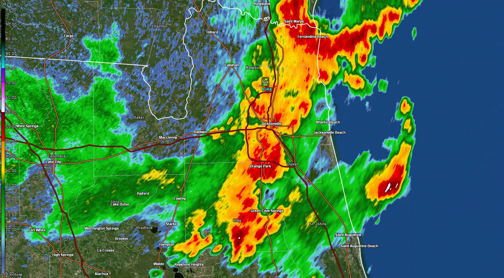
Note: KJAX radar went down just before the event started.
Environment
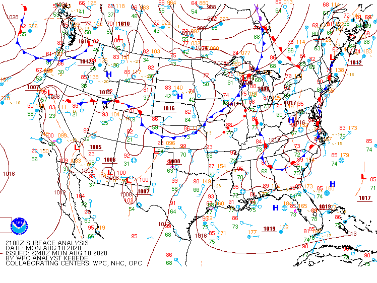
The region was in between high pressure to the east and a trough to the northwest. Westerly steering flow and deep tropical moisture with Precipitable Water Amounts (PWATs) over 2 inches were in place leading to an active afternoon and evening. A series of upper level shortwaves also moved across the region providing additional instability and lift for daytime thunderstorm development. Thunderstorms first developed over our northern southeast Georgia counties and moved southeastward through the afternoon. Meanwhile, the Atlantic sea breeze was pinned to the I-95 corridor. In the evening hours, the boundary leftover from the Georgia storms collided with the Atlantic sea breeze resulting in rapidly developing thunderstorms along the I-95 corridor from the Georgia/Florida state border to Clay county. The heavy downpours from the stronger thunderstorms resulted in areas receiving about 2 to 5 inches of rain.
 |
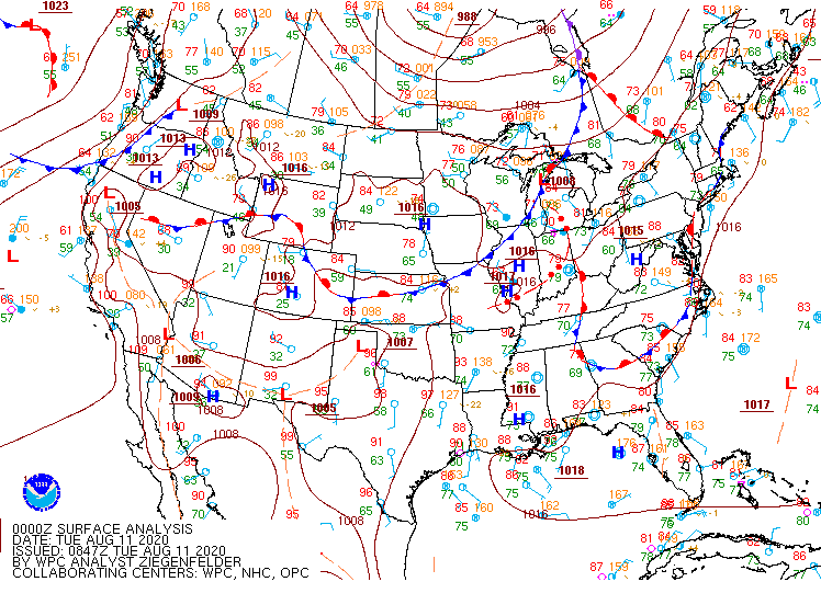 |
| Figure 1: WPC Surface Analysis 08/10/20 21Z | Figure 2: WPC Surface Analysis 08/11/20 00Z |
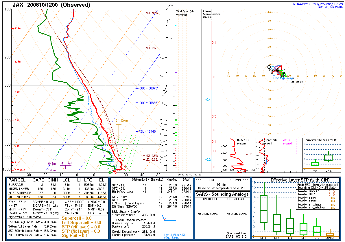
Upper Air Soundings at JAX
 |
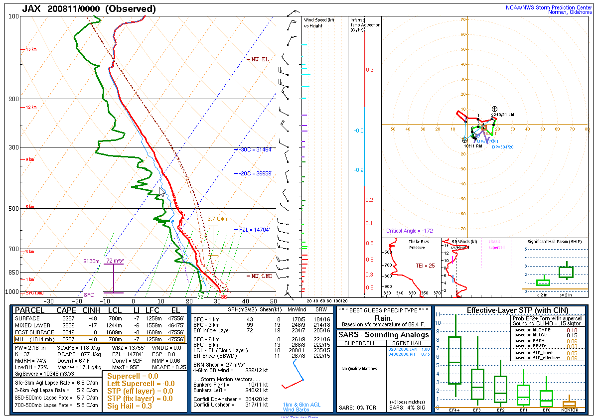 |
| Figure 4: JAX sounding at 08/10 12Z | Figure 5: JAX sounding at 08/11 00Z |
Records
...DAILY RECORD HIGH PEAK WIND GUST SET AT JACKSONVILLE FL...

...9TH HIGHEST WIND GUST ON RECORD FOR THE MONTH OF AUGUST...

...HIGHEST WIND GUST IN AUGUST SINCE TROPICAL STORM FAY IN 2008...

A DAILY RECORD HIGH PEAK WIND GUST OF 55 MPH FROM THE NORTHEAST WAS
SET AT THE JACKSONVILLE AIRPORT DURING A HEAVY THUNDERSTORM AT 749
PM EDT THIS EVENING. THIS BROKE THE PREVIOUS RECORD OF 45 MPH SET
ON 08-10-1918. DAILY WIND RECORDS DATE BACK TO 1871 AT JACKSONVILLE.

THIS WAS THE 9TH HIGHEST WIND GUST ON RECORD FOR THE MONTH OF
AUGUST. THE AUGUST PEAK WIND GUST RECORD IS 85 MPH SET ON 08-27-1949.
THIS WAS THE STRONGEST WIND GUST AT THE JACKSONVILLE AIRPORT SINCE
TROPICAL STORM FAY IN AUGUST OF 2008.

$$

...RECORD DAILY MAXIMUM RAINFALL SET AT JACKSONVILLE FL...

A RECORD RAINFALL OF 3.5" WAS SET AT JACKSONVILLE FL FOR
AUGUST 10. THIS BREAKS THE OLD RECORD OF 1.92" SET IN 1894.


$$

...RECORD DAILY MAXIMUM RAINFALL SET AT CRAIG MUNI ARPT FL...

A RECORD RAINFALL OF 0.9" WAS SET AT CRAIG MUNI ARPT FL FOR
AUGUST 10. THIS BREAKS THE OLD RECORD OF 0.75" SET IN 2014.


$$
 |
Media use of NWS Web News Stories is encouraged! Please acknowledge the NWS as the source of any news information accessed from this site. |
|

