Overview
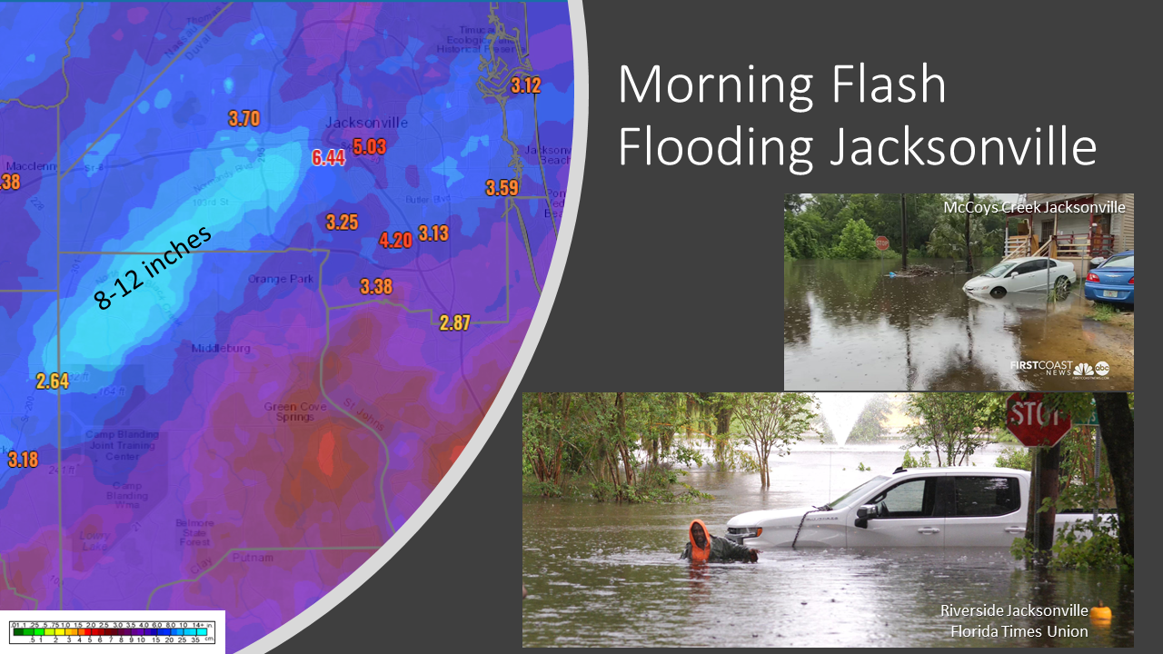
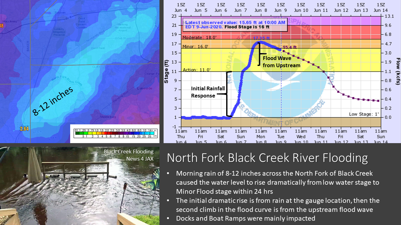
A band of heavy rainfall lifted north across NE Florida during the pre-dawn hours dropping 5-10" of rain in 6 hours across parts of NE Florida, including Clay and Duval counties. Flash flooding occurred across the Jacksonville Westside near I-295 to McCoys Creek in Downtown Jacksonville. This band stalled and lingered just north of the I-10 corridor of North Florida through the day. Strong low level winds on the east side of TS Cristobal near the LA Gulf Coast pumped very high moisture across NE Florida. Flash flooding rainfall of 8-15" occurred across parts of NE Florida along this stalled band of rainfall with area rivers rapidly rising from near low water stages to flooding within 24 hours.
As the rain deluge continued into the afternoon over Echols, Hamilton, and Suwannee counties, isolated tornadoes occurred just south of the I-10 corrdor due to strong low level dynamics and instability. The tornado threat decreased into the evening, but flood waters continued to rise, especially in drainages and main stem rivers.
 |
 |
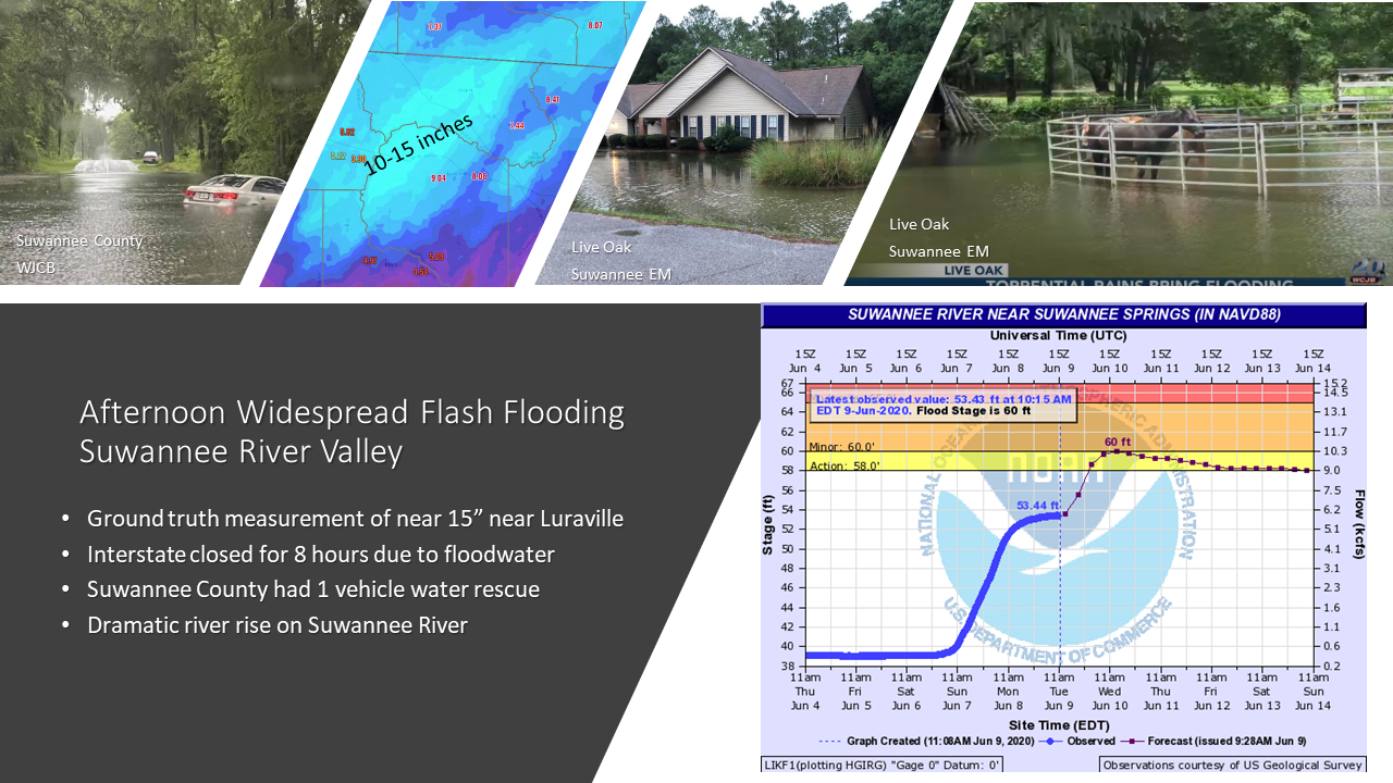 |
| Images of Jacksonville flash flooding in McCoys Creek and Riverside courtesy of First Coast News and the Florida Times Union respectively. | Image of flooding at Black Creek courtesy of News | Images of flooding in Suwannee County via WJCB and in Live Oak via the Suwannee County EM. |
Tornadoes:
|
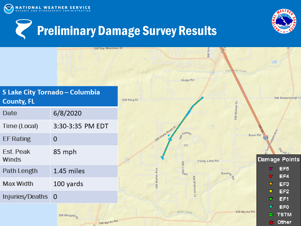
Tornado - S Lake City, FL
|
||||||||||||||||
|
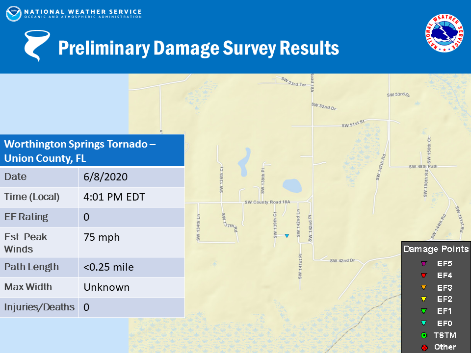
Tornado - Worthington Springs, FL
|
||||||||||||||||
The Enhanced Fujita (EF) Scale classifies tornadoes into the following categories:
| EF0 Weak 65-85 mph |
EF1 Moderate 86-110 mph |
EF2 Significant 111-135 mph |
EF3 Severe 136-165 mph |
EF4 Extreme 166-200 mph |
EF5 Catastrophic 200+ mph |
 |
|||||
Rain Reports
Public Information Statement
National Weather Service Jacksonville FL
238 PM EDT Mon Jun 8 2020

...SELECTED 48 HOUR PRECIPITATION REPORTS...

Location                     Amount    Time/Date       Lat/Lon

...Florida...

...Alachua County...
Gainesville                  6.08 in   0225 PM 06/08   29.67N/82.39W
Gainesville 8.1 SW           5.99 in   0730 AM 06/08   29.59N/82.43W
Gainesville 7.5 WSW          5.49 in   0700 AM 06/08   29.65N/82.46W
Gainesville 3.0 WNW          5.47 in   0726 AM 06/08   29.68N/82.38W
5.7 S High Springs           5.24 in   0200 PM 06/08   29.74N/82.61W
Gainesville 5.4 W            5.20 in   0700 AM 06/08   29.68N/82.43W
Archer 5.5 E                 5.02 in   0830 AM 06/08   29.53N/82.43W
Gainesville 6.5 NW           4.91 in   0730 AM 06/08   29.74N/82.42W
Gainesville 8.5 SW           4.88 in   0700 AM 06/08   29.58N/82.43W
Gainesville 6.5 NW           4.85 in   0630 AM 06/08   29.74N/82.42W
Gainesville 2.4 SW           4.82 in   0644 AM 06/08   29.65N/82.36W
Brooker 6.6 SSE              4.79 in   0900 AM 06/08   29.80N/82.28W
Gainesville 0.6 NE           4.46 in   0700 AM 06/08   29.68N/82.33W
Gainesville 1.7 SE           4.26 in   0700 AM 06/08   29.66N/82.32W
Alachua                      4.21 in   0227 PM 06/08   29.79N/82.51W
Gainesville                  4.08 in   0226 PM 06/08   29.66N/82.33W
Gainesville                  4.07 in   0215 PM 06/08   29.73N/82.42W
Gainesville 3.9 S            3.79 in   0600 AM 06/08   29.62N/82.34W
Hawthorne 5.0 WNW            3.78 in   0730 AM 06/08   29.62N/82.17W
Gainesville                  3.69 in   0216 PM 06/08   29.81N/82.30W
Gainesville 5.1 S            3.68 in   0800 AM 06/08   29.60N/82.35W
Gainesville                  3.47 in   0153 PM 06/08   29.70N/82.28W
High Springs                 3.42 in   0226 PM 06/08   29.74N/82.62W
Micanopy 2.1 NNE             3.28 in   0700 AM 06/08   29.53N/82.27W
Gainesville                  3.22 in   0215 PM 06/08   29.66N/82.32W
Micanopy 2.1 WNW             2.85 in   0700 AM 06/08   29.52N/82.31W
3.0 NE Orange Heights        2.76 in   0200 PM 06/08   29.75N/82.10W

...Baker County...
Eddy Tower                   7.10 in   0204 PM 06/08   30.54N/82.34W
Glen St. Mary 4.4 SW         6.72 in   0700 AM 06/08   30.24N/82.22W
1.5 W Glen Saint Mary        5.81 in   0800 AM 06/08   30.27N/82.19W
Glen St. Mary 1.7 N          5.68 in   0800 AM 06/08   30.30N/82.16W
Olustee                      5.33 in   0204 PM 06/08   30.25N/82.42W
Glen St Mary                 4.94 in   0201 PM 06/08   30.36N/82.23W

...Clay County...
Orange Park 0.5 SSW          4.81 in   0600 AM 06/08   30.16N/81.71W
Keystone Heights 7.6 ENE     4.72 in   0700 AM 06/08   29.84N/81.92W
Keystone Heights 9.7 ENE     4.70 in   0800 AM 06/08   29.85N/81.89W
Orange Park 4.1 WSW          4.51 in   0700 AM 06/08   30.14N/81.77W
Keystone Heights 10.0 NE     4.45 in   0800 AM 06/08   29.86N/81.90W
Keystone Heights 3.5 ENE     4.29 in   0800 AM 06/08   29.80N/81.98W
Keystone Heights 9.1 NE      4.00 in   0800 AM 06/08   29.87N/81.92W
Fleming Island 2.2 S         3.99 in   0700 AM 06/08   30.06N/81.71W
Fleming Island 1.3 NE        3.89 in   0700 AM 06/08   30.11N/81.70W
Keystone Heights 1.0 E       3.85 in   0700 AM 06/08   29.78N/82.02W
2 W Switzerland              3.71 in   0800 AM 06/08   30.08N/81.70W
Fleming Island 2.0 SE        3.67 in   0800 AM 06/08   30.08N/81.69W
Penney Farms 0.1 E           3.28 in   0745 AM 06/08   29.98N/81.81W
Green Cove Springs 2.6 WNW   2.40 in   0700 AM 06/08   30.01N/81.72W

...Columbia County...
White Springs 1.0 SSE        10.06 in  0700 AM 06/08   30.32N/82.75W
White Springs 1.0 SSE        9.79 in   0700 AM 06/08   30.32N/82.75W
Benton 2nnw                  8.66 in   0200 PM 06/08   30.51N/82.67W
Watertown                    6.12 in   0700 AM 06/08   30.18N/82.59W
Mikesville 3 SE              5.82 in   0100 PM 06/08   29.92N/82.61W
Lake City 7.9 SSW            5.79 in   0700 AM 06/08   30.08N/82.67W
Lake City 8.7 S              5.63 in   0700 AM 06/08   30.07N/82.62W
1.6 NE Ichetucknee Spring    3.54 in   0100 PM 06/08   29.98N/82.75W
Fort White                   0.02 in   0225 PM 06/08   29.88N/82.66W

...Duval County...
Jacksonville                 7.89 in   0226 PM 06/08   30.31N/81.69W
Jacksonville 5.0 WSW         7.86 in   0905 AM 06/08   30.32N/81.74W
Jacksonville 7.8 SW          7.78 in   0900 AM 06/08   30.26N/81.75W
Jacksonville 5.9 SW          7.42 in   0700 AM 06/08   30.28N/81.73W
Jacksonville                 7.11 in   0228 PM 06/08   30.36N/81.81W
Jacksonville 4.1 SW          6.54 in   0700 AM 06/08   30.30N/81.71W
Jacksonville 11.4 ESE        6.23 in   0800 AM 06/08   30.31N/81.47W
Jacksonville 9.6 SE          6.00 in   0740 AM 06/08   30.23N/81.56W
Jacksonville 8.8 E           5.50 in   0640 AM 06/08   30.36N/81.51W
Jacksonville 3.8 ESE         5.46 in   0700 AM 06/08   30.32N/81.60W
Jacksonville Beach 1.6 NNW   5.29 in   0700 AM 06/08   30.30N/81.39W
Jacksonville                 5.25 in   0217 PM 06/08   30.21N/81.60W
Jacksonville 4.2 ESE         5.17 in   0800 AM 06/08   30.30N/81.60W
Jacksonville                 5.13 in   0218 PM 06/08   30.26N/81.70W
Jacksonville                 5.10 in   0218 PM 06/08   30.25N/81.69W
Jacksonville                 4.94 in   0228 PM 06/08   30.16N/81.63W
Neptune Beach 0.5 NNW        4.85 in   0800 AM 06/08   30.32N/81.40W
Jacksonville 4.2 NE          4.55 in   0700 AM 06/08   30.38N/81.60W
Jacksonville                 4.52 in   0226 PM 06/08   30.49N/81.57W
Jacksonville                 4.38 in   0225 PM 06/08   30.27N/81.65W
Jacksonville Nas             4.33 in   0153 PM 06/08   30.22N/81.67W
Mayport Naval Station        4.18 in   0152 PM 06/08   30.38N/81.42W
Jacksonville Beach           4.11 in   0131 PM 06/08   30.27N/81.46W
Jacksonville 12.0 SSE        3.87 in   0700 AM 06/08   30.17N/81.58W
Jacksonville                 3.57 in   0226 PM 06/08   30.11N/81.52W
Jacksonville Intl Airport    3.53 in   0156 PM 06/08   30.50N/81.68W
Jacksonville                 3.32 in   0222 PM 06/08   30.50N/81.57W
Fruit Cove 5.9 E             2.27 in   0954 AM 06/08   30.11N/81.52W
Jacksonvil Craig             2.22 in   0153 PM 06/08   30.33N/81.52W

...Flagler County...
Flagler Beach 1.3 SE         3.62 in   0800 AM 06/08   29.46N/81.12W
Palm Coast 2.1 NNE           2.85 in   0700 AM 06/08   29.60N/81.20W
2.1 S Marineland             2.57 in   0730 AM 06/08   29.63N/81.21W
Palm Coast 0.8 NNW           2.35 in   0700 AM 06/08   29.58N/81.22W
Palm Coast 8.3 S             2.32 in   0800 AM 06/08   29.45N/81.22W
Palm Coast                   2.28 in   0216 PM 06/08   29.58N/81.23W
Palm Coast 0.6 ESE           2.18 in   0700 AM 06/08   29.57N/81.21W
Palm Coast 4.2 SSW           2.01 in   0756 AM 06/08   29.52N/81.25W
Palm Coast                   1.95 in   0225 PM 06/08   29.57N/81.17W
Palm Coast 4.5 SSW           1.89 in   0800 AM 06/08   29.51N/81.25W
Palm Coast 3.9 SSW           1.77 in   0700 AM 06/08   29.52N/81.23W
Palm Coast                   1.68 in   0230 PM 06/08   29.57N/81.21W
Palm Coast 1.9 S             1.68 in   0700 AM 06/08   29.54N/81.22W
Palm Coast                   1.64 in   0230 PM 06/08   29.51N/81.25W
Flagler Cnty                 0.77 in   0205 PM 06/08   29.47N/81.20W

...Gilchrist County...
Newberry 4.0 WNW             4.91 in   0800 AM 06/08   29.68N/82.67W
Trenton 8.0 ENE              3.53 in   0803 AM 06/08   29.67N/82.70W
Bell 3n                      3.19 in   0100 PM 06/08   29.80N/82.87W
Trenton                      2.98 in   0230 PM 06/08   29.67N/82.70W
Trenton 4.0 NW               2.94 in   0700 AM 06/08   29.66N/82.86W

...Hamilton County...
Alapaha Tower                10.60 in  0200 PM 06/08   30.53N/83.04W
White Springs 0.3 NW         10.35 in  0700 AM 06/08   30.33N/82.76W
4.9 SW Belmont               7.39 in   0200 PM 06/08   30.44N/82.78W

...Marion County...
Belleview 1.6 E              7.28 in   0700 AM 06/08   29.06N/82.03W
Belleview 3.3 SSW            6.77 in   0700 AM 06/08   29.02N/82.08W
Lake George                  6.22 in   0204 PM 06/08   29.40N/81.81W
Belleview 4.8 E              6.11 in   0700 AM 06/08   29.06N/81.98W
Summerfield 3.0 NE           5.97 in   0700 AM 06/08   29.04N/82.00W
Belleview 6.0 SSE            5.60 in   0700 AM 06/08   28.98N/82.02W
Interlachen 8.8 S            5.54 in   0800 AM 06/08   29.49N/81.90W
Candler                      4.44 in   0230 PM 06/08   29.06N/81.98W
Micanopy 3.6 SSW             4.09 in   0700 AM 06/08   29.46N/82.30W
Lady Lake 4.8 WNW            3.97 in   0700 AM 06/08   28.96N/82.00W
Reddick                      3.84 in   0225 PM 06/08   29.35N/82.24W
Micanopy 4.6 SSE             3.65 in   0700 AM 06/08   29.45N/82.25W
Ocala 3.2 ENE                3.65 in   0700 AM 06/08   29.21N/82.08W
Ocala 10.7 WSW               3.58 in   0700 AM 06/08   29.11N/82.28W
Ocala                        3.35 in   0225 PM 06/08   29.22N/82.19W
Ocala 11.2 SW                3.20 in   0800 AM 06/08   29.07N/82.26W
Clermont                     3.17 in   0215 PM 06/08   29.07N/82.23W
Ocala 1.1 SE                 3.12 in   0700 AM 06/08   29.18N/82.12W
Ocala 2.8 SSE                2.84 in   0700 AM 06/08   29.15N/82.11W
Ocala                        2.81 in   0225 PM 06/08   29.13N/82.28W
Ocala 4.6 N                  2.65 in   0712 AM 06/08   29.25N/82.13W
Weirsdale                    2.41 in   0228 PM 06/08   29.00N/81.92W
Ocala Airport - Jim Taylor F 2.06 in   0158 PM 06/08   29.17N/82.22W

...Nassau County...
Fernandina Beach 0.6 S       4.13 in   0706 AM 06/08   30.65N/81.45W
Yulee                        4.09 in   0222 PM 06/08   30.66N/81.54W
Fernandina Beach 2.3 S       4.04 in   0700 AM 06/08   30.62N/81.44W
Fernandina Beach 2.4 S       3.94 in   0700 AM 06/08   30.62N/81.45W
Hedges 0.3 ESE               3.75 in   0800 AM 06/08   30.60N/81.59W
0.9 W Fernandina Beach       3.75 in   0740 AM 06/08   30.66N/81.46W
Fernandina Beach             2.50 in   0215 PM 06/08   30.62N/81.47W
Yulee                        2.34 in   0217 PM 06/08   30.66N/81.58W

...Putnam County...
Palatka                      2.92 in   0229 PM 06/08   29.64N/81.65W
Hawthorne                    2.75 in   0215 PM 06/08   29.67N/81.95W
Crescent City                2.61 in   0227 PM 06/08   29.39N/81.47W
Crescent City 8.6 WSW        2.57 in   0700 AM 06/08   29.40N/81.65W
Satsuma 4.0 NE               2.32 in   0600 AM 06/08   29.59N/81.61W
Satsuma 0.2 WSW              1.99 in   0630 AM 06/08   29.55N/81.66W
Welaka                       1.97 in   0229 PM 06/08   29.44N/81.63W

...St. Johns County...
Sawgrass 0.0 E               4.92 in   0700 AM 06/08   30.19N/81.37W
Fruit Cove 1.8 N             3.79 in   0800 AM 06/08   30.13N/81.62W
Fruit Cove 1.1 NW            3.40 in   0600 AM 06/08   30.11N/81.63W
Saint Johns                  2.94 in   0225 PM 06/08   30.11N/81.61W
Saint Johns                  2.88 in   0225 PM 06/08   30.12N/81.62W
1 NNW Saint Augustine        2.59 in   0230 PM 06/08   29.91N/81.32W
Fruit Cove                   2.31 in   0229 PM 06/08   30.11N/81.64W
St Augustine                 1.97 in   0156 PM 06/08   29.97N/81.32W
Saint Johns                  1.94 in   0225 PM 06/08   30.06N/81.61W
St. Augustine South 2.1 SSW  1.86 in   0500 AM 06/08   29.81N/81.33W
St. Augustine 3.4 SW         1.76 in   0700 AM 06/08   29.85N/81.34W
Saint Augustine              1.72 in   0228 PM 06/08   29.95N/81.48W
St. Augustine 5.3 WNW        1.71 in   0700 AM 06/08   29.93N/81.39W
St. Augustine 5.1 WNW        1.58 in   0700 AM 06/08   29.92N/81.39W
St Augustine 13 SW           1.58 in   0500 AM 06/08   29.75N/81.47W

...Suwannee County...
Live Oak                     17.43 in  0230 PM 06/08   30.38N/83.08W
3.9 N Houston                7.63 in   0200 PM 06/08   30.31N/82.90W
6.2 NE Midway                4.35 in   0200 PM 06/08   30.09N/83.03W

...Union County...
3.6 NW Lake Butler           4.31 in   1200 PM 06/08   30.04N/82.39W

...Georgia...

...Appling County...
Baxley 0.7 NNE               0.36 in   0700 AM 06/08   31.77N/82.35W
Baxley                       0.32 in   0225 PM 06/08   31.79N/82.39W

...Brantley County...
Waynesville                  2.32 in   0228 PM 06/08   31.23N/81.79W
0.7 W Atkinson               1.71 in   0100 PM 06/08   31.22N/81.87W

...Camden County...
Kingsland 2.9 NE             5.14 in   0800 AM 06/08   30.82N/81.63W
St. Marys 2.1 SW             4.98 in   0700 AM 06/08   30.74N/81.60W
Kingsland                    4.67 in   0216 PM 06/08   30.77N/81.73W
Kingsland 1.2 WSW            4.61 in   0700 AM 06/08   30.79N/81.68W
St. Marys 3.0 SE             4.33 in   0700 AM 06/08   30.72N/81.55W

...Charlton County...
1.3 W Steven Foster State Pa 6.90 in   0820 AM 06/08   30.83N/82.36W
Jones Island                 6.02 in   0201 PM 06/08   30.83N/82.36W
Homeland 0.7 N               5.99 in   0700 AM 06/08   30.87N/82.03W
Oke-East                     5.70 in   0147 PM 06/08   30.74N/82.13W
Folkston                     3.97 in   0216 PM 06/08   30.85N/81.99W
Oke-Nw                       3.92 in   0210 PM 06/08   30.98N/82.40W
3.8 S Folkston               3.53 in   1015 AM 06/08   30.78N/82.02W

...Clinch County...
Fargo                        11.65 in  1245 PM 06/08   30.68N/82.56W
2.1 NE Fargo                 8.48 in   0100 PM 06/08   30.71N/82.54W

...Coffee County...
Douglas 2.5 WSW              0.57 in   0700 AM 06/08   31.49N/82.89W
Pridgen                      0.27 in   0630 AM 06/08   31.70N/82.92W

...Echols County...
Statenville                  4.13 in   0100 PM 06/08   30.70N/83.03W

...Glynn County...
St. Simons 2.7 S             3.05 in   0700 AM 06/08   31.14N/81.39W
Sterling                     2.97 in   0204 PM 06/08   31.26N/81.61W
St. Simons 1.1 SW            2.69 in   0700 AM 06/08   31.16N/81.40W
Brunswick                    2.25 in   0226 PM 06/08   31.28N/81.53W
Brunswick                    1.79 in   0153 PM 06/08   31.15N/81.38W
Lewis                        1.39 in   0215 PM 06/08   31.25N/81.47W

...Pierce County...
Blackshear                   2.23 in   0225 PM 06/08   31.24N/82.29W
1.9 NE Sunnyside             2.22 in   0100 PM 06/08   31.25N/82.31W
Blackshear 3.8 WSW           1.54 in   0600 AM 06/08   31.27N/82.30W

...Ware County...
Manor 3.0 NW                 3.33 in   0700 AM 06/08   31.12N/82.62W
Waycross                     1.58 in   0204 PM 06/08   31.25N/82.40W

...Wayne County...
Doctortown                   0.49 in   0200 PM 06/08   31.65N/81.83W

...Florida...

...Maritime Stations...
Ocean View                   0.63 in   0227 PM 06/08   29.59N/81.21W

Observations are collected from a variety of sources with varying
equipment and exposures. We thank all volunteer weather observers
for their dedication. Not all data listed are considered official.

$$
Environment
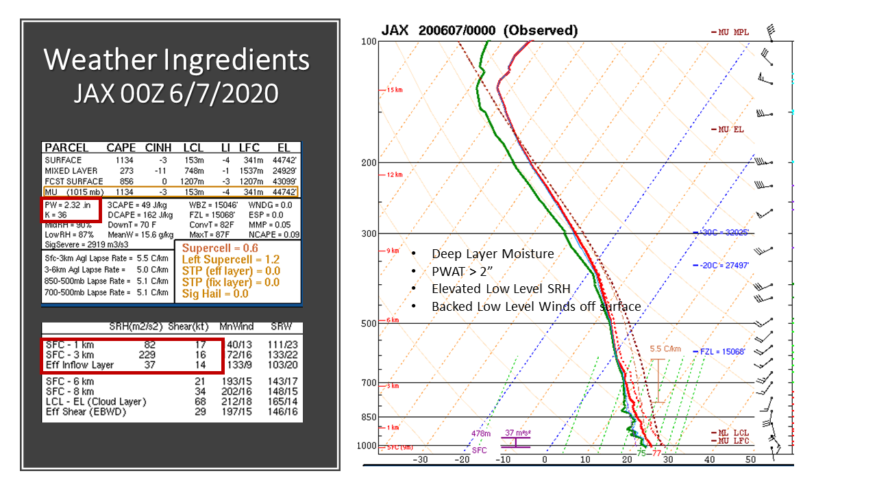
Deep tropical moisture streamed over the region on the east side of TS Cristobal in the Gulf with precipitable water values of 2-2.5 inches across SE Georgia and NE Florida. A surface trough extended east of Cristobal (warm front) and lifted northward over north-central FL overnight June 6th through June 7th.
Convergence between the surface front over Florida and a strengthen high pressure ridge over GA/SC essentially ‘squeezed’ flooding rainfall across the area. This band of flooding rain stalled & meandered just north of the I-10 corridor June 7th as high pressure & dry air nosed south from over eastern GA/SC which ceased the northward progression of the heavy rain shield.
As TS Cristobal neared landfall along the central Gulf Coast over LA in the afternoon June 7th, strong SSW 850 mb jet of 35-40 kts increased over the area and pumped very moist air inland across N FL from the GOMEX, and causing stronger convergence and thus heavier rainfall near the stalled heavy band of rainfall across the Suwannee River Valley. As the SSW winds strengthened through the day June 7th above the surface, low level shear & helicity between the surface and 3 km AGL increased to support multiple shallow rotating cells, two of which produced confirmed tornadoes, over a very unstable low level airmass.
 |
 |
 |
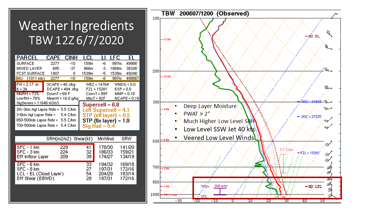 |
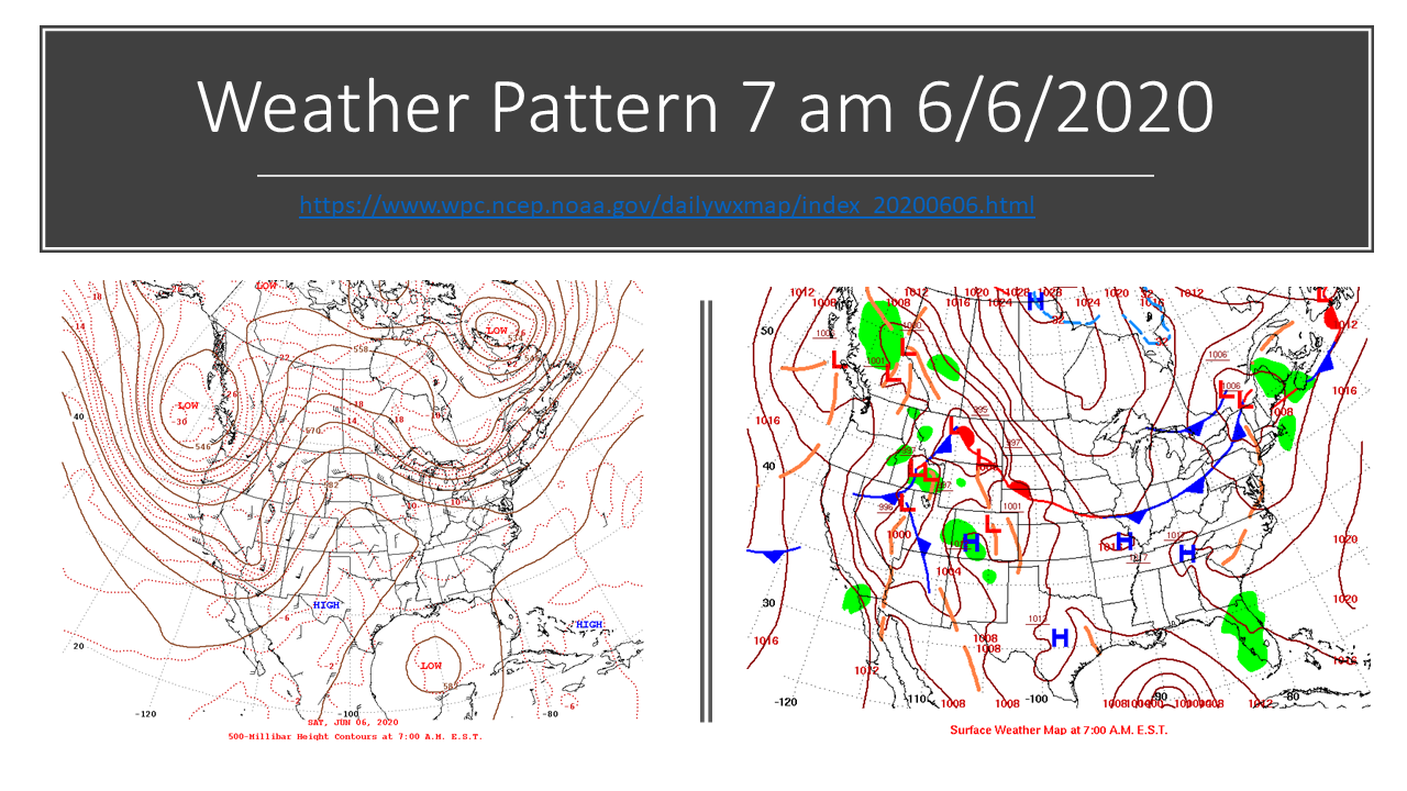
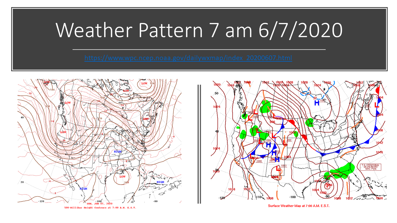
| Figure 1: Weather Pattern at 7 AM on 6/6/2020 | Figure 2: Weather Pattern at 7 AM on 6/7/2020 | Figure 3: KJAX Sounding at 8 PM on 6/6/2020 | Figure 4: KJAX Sounding at 8 AM 6/7/2020 |
National and Local Forecast Products
 |
 |
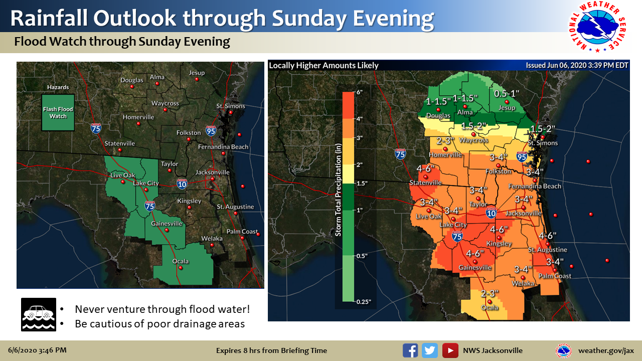 |
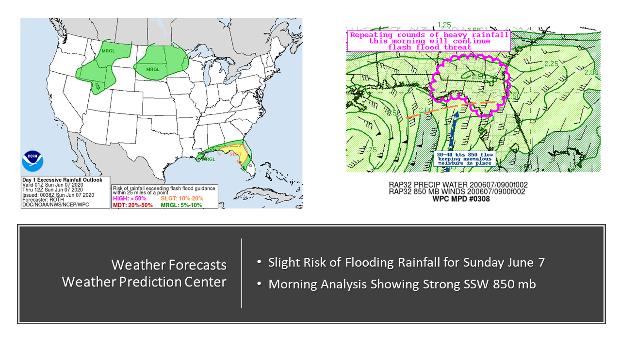
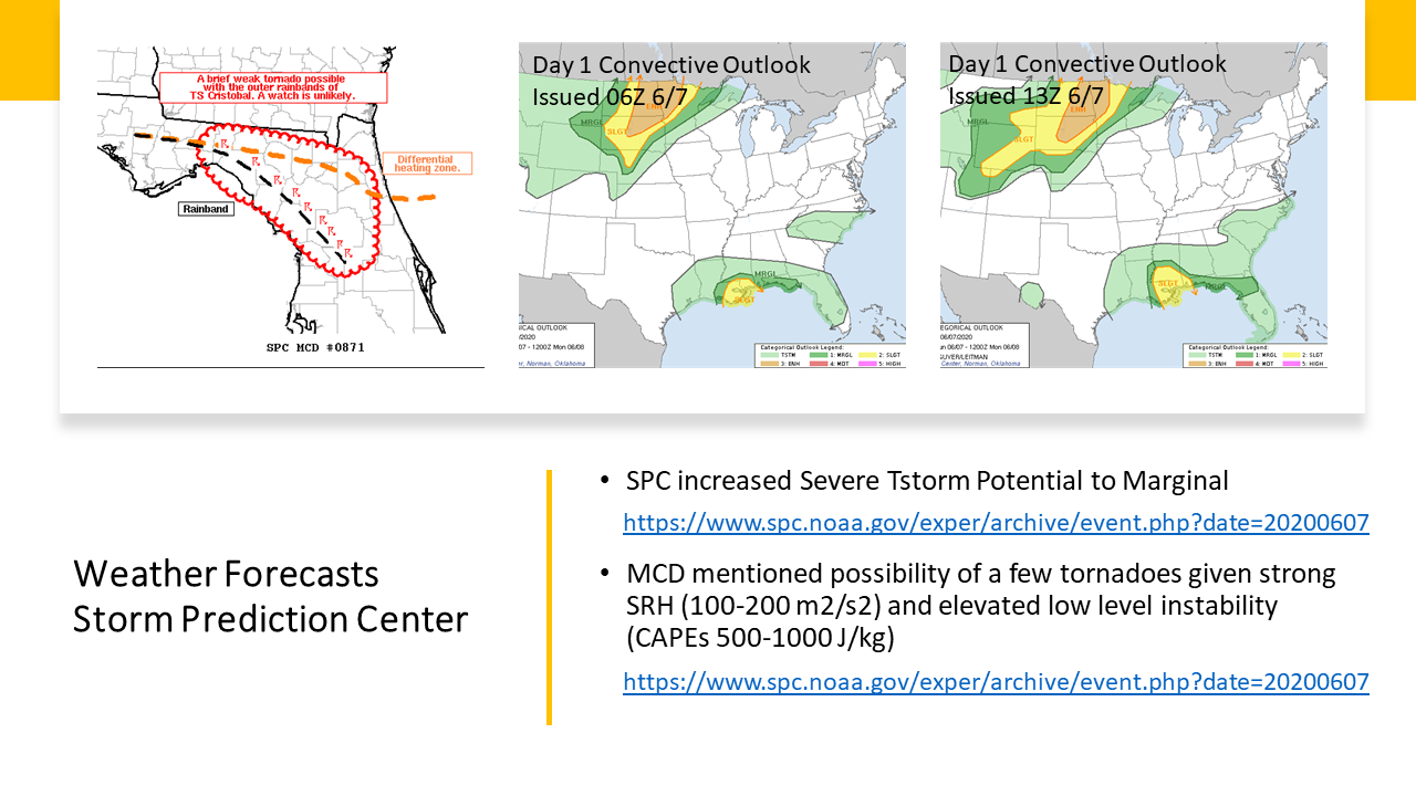
| Figure 5: WPC showed a slight risk for excessive rainfall over the area on 6/7/2020 with their morning analysis showing strong winds from the south-southwest at 850 mb. | Figure 6: SPC upgraded the area from general thunderstorms to a marginal risk for severe weather on the morning of 6/7/2020, mentioning the potential for brief tornadoes in their MCD. | Figure 7: NWS Jacksonville issued a Flash Flood Watch for portions of N Florida on the afternoon of 6/6/2020. |
Photos & Video
Collection of Twitter Reports from June 6-7, 2020
June 6-7, 2020 - Curated tweets by NWSJacksonville |
Media use of NWS Web News Stories is encouraged! Please acknowledge the NWS as the source of any news information accessed from this site. |
|